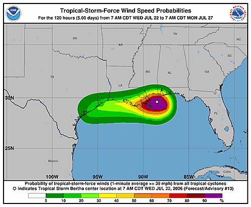

The National Hurricane Center in Miami released Forecast Advisory Number 13 for Tropical Storm Bertha at 3:00 p.m. UTC on Wednesday, July 22, 2026, with the storm’s center pinpointed near coordinates 29.8°N, 88.6°W — a position accurate to within 30 nautical miles.
At the time of the advisory, Bertha was drifting in a west-northwest direction at just 5 knots, roughly equivalent to about 6 miles per hour. The storm’s minimum central pressure was measured at 998 millibars, with maximum sustained winds of 45 knots and gusts climbing to 55 knots. Tropical storm-force winds of 34 knots extended outward up to 90 nautical miles to the southeast of the center.
Looking ahead, forecasters expect the storm to move inland by midnight UTC on July 23, with winds dropping to around 40 knots. By noon on July 23, Bertha is forecast to be back over open water near 29.5°N, 92.7°W, with winds easing further to 35 knots.
The storm is then expected to push inland again by midnight on July 24, maintaining winds of about 35 knots, before weakening significantly into a post-tropical remnant low by noon that day — with winds down to 25 knots and gusts around 35 knots.
By July 25, forecasters expect Bertha to have fully dissipated.
The National Hurricane Center has requested ship reports every three hours from vessels within 300 nautical miles of the storm’s center. The next full advisory was scheduled for 9:00 p.m. UTC Wednesday, with an intermediate public advisory planned for 6:00 p.m. UTC. The advisory was issued by Forecaster Berg.