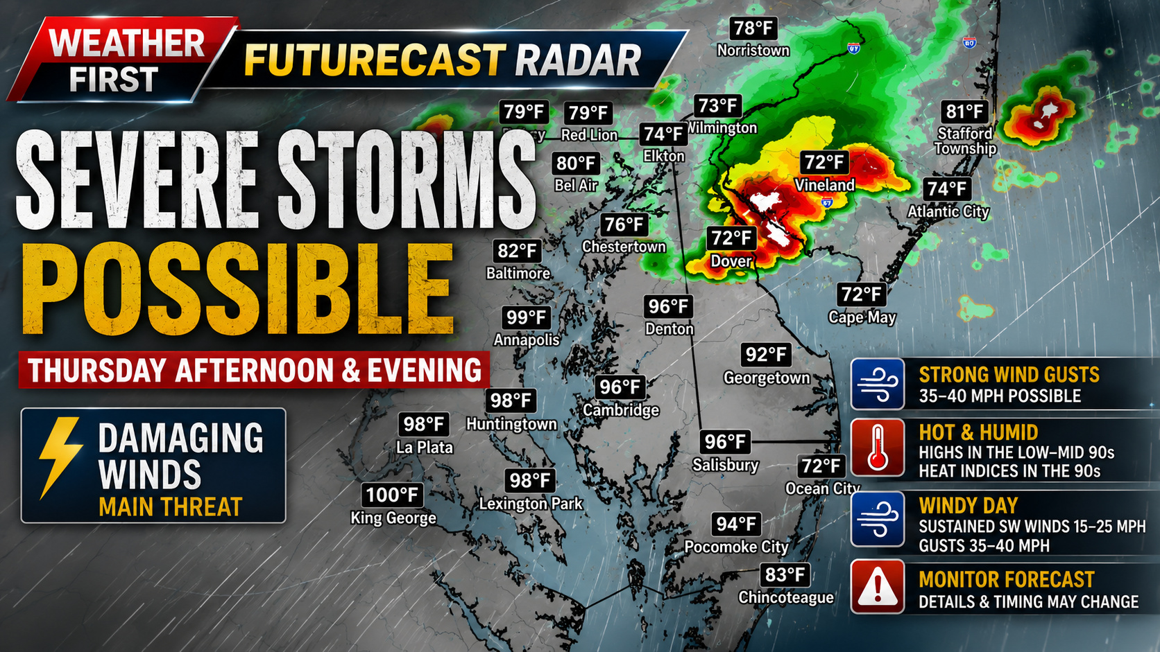

A potentially active weather day is shaping up across the Mid-Atlantic on Thursday as a powerful storm system moves through the Great Lakes and drags a strong cold front toward the region. While some uncertainty remains regarding the exact evolution of the atmosphere, the overall setup is becoming increasingly favorable for severe thunderstorms capable of producing damaging winds.
An upper-level trough will strengthen across the Great Lakes while a deepening area of low pressure tracks into southeastern Canada. In response, very strong southwest winds will develop throughout the atmosphere, transporting increasing heat and humidity into the region during the day Thursday.

The biggest forecast question remains how much instability can develop before thunderstorms arrive. Early morning clouds or showers could limit daytime heating in some locations, while a faster return of moisture and sunshine would allow the atmosphere to become much more unstable. Even if instability remains only modest, we are confident that exceptionally strong wind fields and powerful upper-level dynamics will be more than sufficient to support organized severe thunderstorms.

Wind shear values exceeding 50 knots are forecast across the region, an impressive setup for the middle of June. Combined with strengthening forcing along the approaching cold front, thunderstorms are expected to organize into clusters or line segments capable of producing widespread damaging straight-line winds.
While damaging winds appear to be the primary hazard at this time, the environment will need to be monitored closely for any increase in instability. Should storms become more discrete before evolving into a line, all modes of severe weather, including large hail and even an isolated tornado, could become possible.

Away from the thunderstorms themselves, Thursday is also expected to be unusually windy. Sustained southwest winds of 15 to 25 mph with gusts between 35 and 40 mph are likely throughout the afternoon, making for a very breezy day even before storms develop.

Temperatures will climb into the lower and middle 90s across much of the region, with heat indices reaching the 90s ahead of the approaching front. The combination of hot, humid, and windy conditions will set the stage for potentially intense thunderstorms during the afternoon and evening hours.
While finer details regarding timing and storm intensity will become clearer over the next 24 to 36 hours, residents across Delmarva and the surrounding Mid-Atlantic should closely monitor the latest forecasts. The overall pattern strongly supports the potential for severe weather, with damaging winds currently appearing to be the greatest concern.