
Chinese military forces have been operating surveillance drones over the South China Sea while broadcasting deceptive identification signals, according to new analysis of flight tracking data reported by Reuters.
The large military drone has been conducting routine missions in recent months while transmitting fraudulent transponder codes that disguised it as various other aircraft, including a sanctioned cargo plane from Belarus and a British Typhoon fighter jet.
Defense experts and military officials analyzing these operations believe the flights mark a significant escalation in China’s gray-zone military tactics in the disputed waters and may represent preparation for potential invasion scenarios involving Taiwan.
Flight tracking data reveals that since August, no fewer than 23 missions have been recorded using the call sign YILO4200, identified as a Chinese military drone with extended flight capabilities. However, the aircraft broadcast registration codes belonging to completely different planes during these operations.
The drone’s typical flight routes originate from China’s Hainan province and head eastward toward the Philippines, passing near the contested Paracel Islands and along Vietnam’s coastline.
This represents the first comprehensive reporting on the scope and sophistication of these deceptive operations.
According to regional diplomatic sources, intelligence specialists, and security researchers who have examined the flight information, these missions demonstrate a new level of complexity in China’s expanding military presence throughout the South China Sea and around Taiwan. The operations involve real-time deployment of electronic warfare and deception techniques as China’s military works to enhance combat readiness.
While such masking techniques may not completely fool air traffic control systems or advanced military radar, they could create costly delays and confusion during actual conflict, hide sensitive intelligence gathering, or serve propaganda purposes, according to diplomatic and intelligence sources.
Ben Lewis, who founded the open-source intelligence platform PLATracker, said the operations were unprecedented.
“We’ve not seen anything like this before,” Lewis stated. “It’s … a kind of deception trial being carried out in real time using aircraft that are not exactly low profile. It does not appear to be at all accidental.”
China’s defense ministry has not responded to inquiries about these flights or their intended purpose.
The flights have primarily appeared on flight tracking systems as an Ilyushin-62 cargo aircraft operated by Belarus-based Rada Airlines, though they have also masqueraded as a Royal Air Force Typhoon, a North Korean Il-62 passenger aircraft, and an unidentified Gulfstream business jet.
Since mid-December, the drone designated YILO4200 has also conducted several missions in northwestern China, most recently on February 15 when it transmitted signals identifying it as an anonymous Pilatus PC-12 turboprop passenger plane.
Aircraft identification codes originate from a specialized 24-bit address system managed by the International Civil Aviation Authority. These numbers, transmitted through transponder systems, help determine an aircraft’s location, heading, and velocity.
Though each aircraft receives a unique address, these codes are publicly available, and aviation experts confirm that reprogramming a transponder to broadcast a different registration number is technically feasible.
The U.S. Office of Foreign Assets Control sanctioned Rada Airlines in August 2024 for transporting cargo to and from Africa that included Wagner Group personnel connected to Russian military operations, as well as involvement in illegal wildlife trafficking.
Flight data shows the actual Belarusian Il-62 aircraft remained active during this period using its legitimate call sign and was even airborne simultaneously with the Chinese drone that was impersonating it.
Rada Airlines has not responded to requests for comment, and Britain’s defense ministry declined to provide statements on the matter.
An International Civil Aviation Organization representative said the organization does not comment on issues or speculation regarding specific member nations.
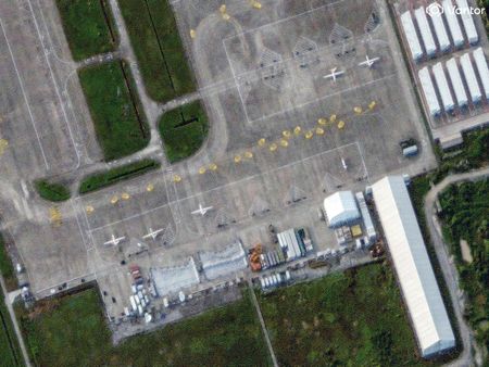
Operating from Qionghai Boao International Airport in Hainan, the aircraft typically remained airborne for extended periods, flying distinctive star-shaped or hourglass patterns over identical areas repeatedly.
These flight characteristics match those commonly associated with large military drones conducting surveillance missions and covered strategically important sections of the South China Sea, including waters frequently used by submarines, according to intelligence analysts reviewing the data.
Chinese military forces typically operate their drones in “dark” mode, transmitting neither call signs nor registration identifiers.
Two missions among the 23 examined were particularly noteworthy: During one flight spanning August 5-6, the drone initially broadcast the RAF Typhoon’s identification code, then switched between three different aircraft signals over approximately 20 minutes before finally landing while transmitting the Rada Airlines identifier.
In another instance on November 18, the drone operated while impersonating the Belarusian aircraft at the same time the genuine Rada Il-62 departed from near Belarus bound for Tehran.
Alexander Neill, a Singapore-based security analyst, described the Hainan operations as representing a novel approach within China’s digital warfare capabilities designed to “muddy the waters” if regional tensions escalate into armed conflict.
“They don’t appear to be exercises as much as the kind of action the U.S. Indo-Pacific Command has described as rehearsals for a confrontation – anything the Chinese can do to sow confusion in the minds of their rivals is to their advantage,” Neill explained. Neill serves as a fellow at Hawaii’s Pacific Forum.
“The U.S. and its allies know that given the realities of highly automated conventional conflict, even milliseconds count along the kill chain of escalation.”
The Pentagon has not responded to requests for comment regarding the Chinese drone operations.
Lewis and three additional open-source intelligence analysts identified the YILO4200 call sign as belonging to an extended-range Wing Loong 2 unmanned aircraft, comparable to the U.S. Reaper drone with a 67-foot wingspan.
The Wing Loong primarily serves surveillance functions but can be configured for additional roles including command and control operations, precision missile attacks, and anti-submarine warfare.
State-connected Chengdu Aircraft Corporation, an AVIC subsidiary, manufactures the aircraft but declined to comment on the matter.
Flight tracking specialist Amelia Smith originally linked the Wing Loong 2 to the call sign through analysis of flight data, official press reports, and government announcements.
Lewis, Smith, and other intelligence analysts said it remains unclear which Chinese agency operates the aircraft from Boao Airport, which serves both commercial and military purposes.
Satellite imagery from July, September, and January obtained show large drones positioned on the airport’s tarmac alongside support facilities in a section currently undergoing expansion.
Ian Petchenik, communications director for Flightradar24, confirmed the tracking service had observed the Hainan flights and had not encountered similar activity previously, apart from apparent accidental miscoding, nonexistent addresses, or data corruption.
“Based on the flight patterns and the kind of usage of these 24-bit addresses, it doesn’t seem like it is a mistake in the programming of the transponders,” Petchenik stated.
It could not be determined whether the flights follow pre-programmed routes or receive ground-based control.
The flight paths traverse areas of significant naval activity, including waters south of Hainan near Chinese submarine installations and eastward toward the Bashi Channel between Taiwan and the Philippines – a critical passage point for China’s navy to reach the Pacific Ocean.
Security analyst Neill suggested the route patterns indicate preparation for operations over Taiwan.
When the 23 flight paths are mapped over Taiwan, they pass numerous military locations of strategic importance, concentrated around Taipei while also extending along the island’s southern coast. The eastward trajectories bring the aircraft near Japanese and U.S. military installations in Okinawa and other Ryukyu chain islands.
“It is a compelling image – extensive rehearsals across the South China Sea to be deployed over Taiwan’s key points,” Neill observed.