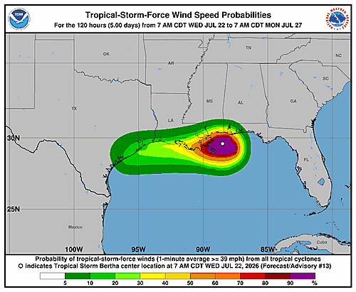

The National Hurricane Center in Miami released Forecast Advisory Number 8 for Tropical Storm Bertha at 9:00 a.m. UTC on Tuesday, July 21, 2026.
As of the advisory, the storm’s center was pinpointed near latitude 28.7 degrees North and longitude 86.4 degrees West, with that position considered accurate within 30 nautical miles. Bertha is drifting to the northwest at a sluggish pace of just 4 knots, or roughly 5 miles per hour.
The storm’s minimum central pressure stands at 998 millibars. Maximum sustained winds are currently at 45 knots — about 52 miles per hour — with gusts climbing to 55 knots. Tropical storm-force winds of 34 knots or greater extend outward up to 70 nautical miles to the southeast and southwest of the center.
Looking ahead, forecasters project Bertha will strengthen slightly by Tuesday evening, with maximum winds reaching 50 knots and gusts up to 60 knots. The storm is then expected to gradually weaken as it continues its slow westward drift.
By early Thursday morning, July 23, the center is forecast to move inland, still carrying winds of 35 knots with gusts to 45 knots. Later that same day, the storm is expected to emerge back over open water before eventually reaching the coast again by early Friday, July 24, with 30-knot winds and 40-knot gusts.
In the extended outlook, Bertha is expected to become a post-tropical remnant low by Saturday, July 25, with winds down to 25 knots. The system is forecast to fully dissipate by Sunday, July 26.
Forecasters note that track errors for days four and five average around 125 and 175 nautical miles respectively, with intensity errors averaging approximately 15 knots per day during that extended period.
The next advisory was scheduled for 3:00 p.m. UTC on Tuesday. Ships within 300 nautical miles of the storm’s center have been asked to submit reports every three hours. The advisory was issued by Forecaster Papin.