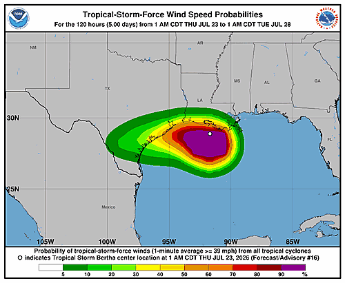

The National Hurricane Center issued its latest forecast discussion on Tropical Storm Bertha at 4:00 AM CDT Thursday, July 23, 2026, with radar data and surface observations confirming that the storm’s center has moved — or possibly re-formed — off the coast of southern Louisiana.
Bertha is generating a large area of heavy thunderstorm activity concentrated in its southwestern quadrant, while the elongated low-level center sits along the northeastern edge of that convection. Surface readings and scatterometer data place maximum sustained winds near 40 knots (about 45 mph), with a minimum central pressure of approximately 1003 millibars.
Doppler radar data from the coast also reveals that the storm’s mid-level center is positioned well to the southwest of the low-level center. A persistent supercell thunderstorm with a rotating mesocyclone has been observed moving westward through Bertha’s southwestern quadrant.
Forecasters describe the storm’s initial motion as a somewhat uncertain westward track at around 11 knots. A large, powerful mid-level high-pressure system sitting over the south-central United States is acting as the main steering force. Bertha is expected to travel along the southern edge of that high-pressure area over the next day or so, with the center making landfall along the upper Texas or southwestern Louisiana coast later today.
After coming ashore, the storm is forecast to continue in a west-southwestward direction before eventually breaking down. The updated track is largely consistent with earlier forecasts, though forecasters warn that some erratic movement is possible ahead of landfall due to potential center shifts driven by bursts of convection.
Significant strengthening before landfall is considered unlikely, as moderate to strong northeasterly wind shear combined with dry air moving into the storm should act as a limiting factor. Weakening is anticipated once Bertha moves inland, with full dissipation forecast between 36 and 48 hours after landfall.
The National Hurricane Center highlighted three key messages for residents in the affected region:
Tropical storm conditions are expected to push westward along the northwestern Gulf Coast, stretching from south-central Louisiana to the upper Texas coast throughout the day. A Coastal Flood Warning is currently in effect for parts of the Mississippi and Louisiana coastlines, where moderate coastal flooding is anticipated. Additionally, isolated flash flooding remains possible along the Texas Gulf Coast and into South Texas through tonight.
Forecast positions show the storm at 29.0°N, 92.2°W at the time of the advisory, moving to an inland position near 29.0°N, 97.0°W by 24 hours out, and degrading to a post-tropical remnant low by the 36-hour mark before dissipating entirely by 48 hours. The forecast was issued by Forecaster Beven.