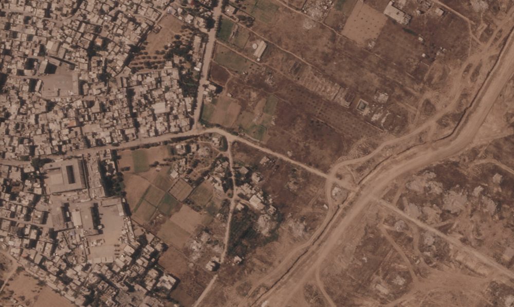

CAIRO — Satellite imagery reveals that the Israeli military has been steadily constructing a massive earthen barrier inside Gaza, carving the territory into two distinct sections — one under Israeli control and the other home to the bulk of the displaced Palestinian population.
More than 23 kilometers, or roughly 14 miles, of the barrier have been built over recent months. That represents more than half the total length of the Gaza Strip, a narrow coastal territory approximately 40 kilometers long and 11 kilometers wide that is home to more than 2 million Palestinians. The barrier cuts through Palestinian communities that have already been demolished by the Israeli military.
When The Associated Press presented the satellite images to the Israeli military, officials confirmed the construction of a physical barrier along what has been called the “yellow line” — the boundary to which Israeli troops pulled back under the ceasefire agreement reached with Hamas in October. That line was originally intended under the U.S.-backed deal as a temporary division of the territory while a broader Israeli withdrawal was negotiated.
However, with the ceasefire largely stalled, concerns are mounting that what was meant to be a temporary boundary is taking on the characteristics of a permanent border. Neither U.S. Central Command, which is responsible for monitoring the ceasefire, nor the Board of Peace — the U.S. President Donald Trump-led body meant to eventually oversee Gaza — agreed to comment on the barrier’s construction.
In addition to the barrier itself, the Israeli military told the AP it has established a “security zone” along the line, outfitted with intelligence-gathering and technological systems. The military declined to specify the barrier’s full planned route or how far it would ultimately extend, saying only that it was designed to stop infiltration and protect Israeli troops and communities near Gaza.
Most Palestinians living in Gaza remain unaware of the growing berm network — largely because approaching the area is too dangerous. Since the ceasefire began, fears have grown among Gaza’s population that Israel has no intention of relinquishing the territory it currently holds.
Satellite images provided by Planet Labs PBC show that one section of the berm network in southern Gaza grew by more than 2 kilometers — about 1.2 miles — in just two weeks this month. On July 1, that segment measured around 500 meters. By July 15, it had grown to approximately 2.4 kilometers, effectively separating Israeli-controlled ruins of the city of Rafah from the Muwasi area, where some of the largest Palestinian tent camps are located.
If construction continues on its current path, this southern section will connect with the longest stretch of the barrier, which runs nearly uninterrupted for approximately 17 kilometers — about 10 miles — from the southern city of Khan Younis to the outskirts of Gaza City in the north. Work on that stretch began in February, and satellite imagery suggests the extension is ongoing. More than a kilometer was added between June 21 and July 7, running close to an Israeli military base built on the ruins of the town of Bani Suheila, near Khan Younis.
In the far north of Gaza, several disconnected berm segments have been observed just outside the largely flattened town of Beit Lahia.
The exact height of the berms is not clear from the imagery. In certain locations, the barriers appear to extend beyond the yellow line itself.
Gaza’s civilian population has been pushed into the coastal area west of the yellow line, with most people living in overcrowded tent camps and relying on humanitarian aid to survive. On the Israeli-controlled eastern side, satellite images show that the military has leveled nearly all structures using bulldozers and explosives, effectively erasing entire towns — including Rafah, which once housed more than a quarter million residents. New road networks and military bases have been built on the ruins, and agricultural land has also been destroyed. The Israeli military says it is dismantling infrastructure used by Hamas.
The yellow line was never precisely defined in the ceasefire agreement or by Israeli or U.S. officials, and it has been inconsistently marked on the ground. The Israeli military told the AP it is working to more clearly mark the route of the line in order to “reduce friction and prevent harm to uninvolved individuals.”
Israeli forces have shot and killed Palestinians who came near or crossed the line. The military says it fires on individuals it believes to be militants posing a threat to troops. However, those killed have included children and civilians who appeared unaware of the boundary. Some soldiers have acknowledged they do not always know who they are shooting at and that orders exist to kill anyone crossing the line.
Since the ceasefire took effect, Israeli forces have killed more than 1,100 Palestinians, with most deaths resulting from airstrikes and drone strikes across Gaza. The military says it is targeting militants. During the same period, militant attacks have killed five Israeli soldiers.
Under the terms of the ceasefire deal, Israel was supposed to eventually pull its forces back to the outer edges of Gaza, with an international security force stepping in to maintain order. But implementation has been frozen for months. A former United Nations diplomat now overseeing ceasefire coordination has attributed the stall to Hamas’ refusal to disarm. Sporadic negotiations over a weapons decommissioning formula have produced little apparent progress, while Hamas accuses Israel of violating the ceasefire.
The current conflict began when Hamas-led militants launched an attack on Israeli communities on October 7, 2023, killing approximately 1,200 people — most of them civilians — and taking 251 others hostage. Israel launched a major military offensive in response, which has since killed more than 73,000 people according to the Gaza Health Ministry. The ministry, formerly part of the Hamas-run government that was recently dissolved, keeps detailed records that United Nations agencies and international organizations generally consider reliable. It does not separate civilian deaths from militant deaths but reports that women and children account for roughly half of all fatalities.