
A series of earthquakes in recent days — striking California, Venezuela, and Japan — sent warnings to millions of people through their mobile phones, giving them critical seconds to protect themselves before the shaking began.
Venezuela was hit by two deadly earthquakes on Wednesday evening and Thursday morning, while significant tremors also rattled Japan’s northern coast. Earlier in the week, a moderate earthquake struck the U.S. state of California. And at the start of June, 37 people in the Philippines lost their lives in a quake near Mindanao.
Many countries around the world have developed systems designed to alert residents seconds before an earthquake’s shaking arrives. And even in nations that lack those systems — like Venezuela — Google’s Android Earthquake Alerts can still deliver life-saving warnings.
Here’s what you need to know about how these systems work:
According to the U.S. Geological Survey, several countries currently operate Early Earthquake Warning systems — often referred to as EEW. Those countries include the United States, Mexico, Japan, Turkey, Romania, China, Italy, and Taiwan.
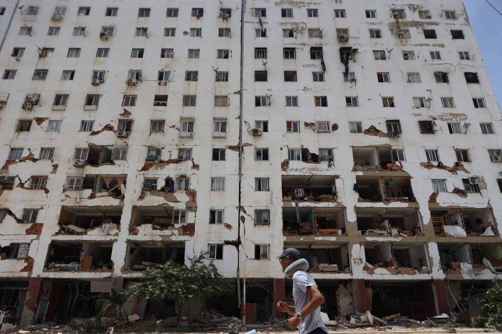
Venezuela is not among them. The back-to-back 7.2- and 7.5-magnitude earthquakes that struck Wednesday evening were among the most powerful to hit the country in over 100 years.
Despite the absence of a national system, some Venezuelans still received advance warnings through Google’s Android Earthquake Alerts platform. That system gathers crowdsourced data from the sensors built into individual smartphones to detect seismic activity and push warnings to nearby users.
Pericles Sánchez, a 39-year-old writer based in Caracas, received a warning on his Android phone several minutes before the earthquake reached his home — giving him enough time to run outside. He said his family’s house was not damaged.
“It wasn’t until we were already outside that we started to feel it,” Sánchez said.
On the U.S. West Coast, the USGS runs a system called ShakeAlert for California, Oregon, and Washington. That system delivers alerts through several channels, including a state-operated app called MyShake. Combined, those platforms notified more than 4 million people ahead of Wednesday’s California earthquake, according to USGS scientist Robert de Groot.
The first public EEW system launched in Mexico back in 1991. Today, Mexicans receive warnings through broadcast stations, mobile apps, and public alarm systems. Mexico City also holds regular earthquake drills so residents know how to respond.
Japan significantly expanded its earthquake warning capabilities following the devastating magnitude 9.0 earthquake and tsunami in 2011, which killed more than 22,000 people and triggered a catastrophic meltdown at the Fukushima Daiichi nuclear power plant. The country built out an underwater monitoring network called the Seafloor Observation Network for Earthquakes and Tsunamis — or S-Net — which uses thousands of miles of undersea cables and sensors to monitor the offshore subduction zone where tectonic plates collide. It is considered the most advanced system in the world, adding roughly 20 seconds to earthquake warning times and making tsunami warnings up to 20 minutes faster.
California’s MyShake app launched in 2019 and has since delivered 6.8 million alerts for 194 separate earthquakes, according to state data.
To understand how these systems work, it helps to know that earthquakes produce several types of seismic waves. P-waves travel the fastest but cause only minor vibrations. S-waves are slower but far more dangerous, producing the intense ground shaking most people associate with earthquakes. L-waves arrive last and are the most destructive of all.
Most EEW systems use seismometers and other sensors to detect these waves, then quickly transmit that data to regional networks. Within seconds, analysts can estimate the earthquake’s location and likely magnitude. If the intensity crosses a certain threshold, alerts are pushed out to areas expected to feel the impact.
In the United States, those alerts go out through the Wireless Emergency Alert system, various apps, and regional warning platforms. Some people may receive multiple alerts for the same event, while others — especially those in rural areas or without phones nearby — may receive none at all.
De Groot of the USGS emphasized the importance of having multiple alert channels in place.
“It’s always good to have more than one way of getting alerts. It’s the reason why you carry a spare tire in your car or carry some small bills in your wallet because the ATM may not work,” he said.
Google’s Android warning system relies on the accelerometers inside smartphones — the same sensors that rotate the screen when you tilt your phone. If a stationary Android device detects a P-wave, it sends a signal to Google’s detection center, which then cross-references data from other phones in the region. That combined data is used to confirm the quake and trigger alerts.
One limitation of these systems is that people closest to an earthquake’s epicenter often receive the shortest warning times — sometimes the shaking has already started before the alert arrives. Those farther from the epicenter may have more time to react, though typically still only seconds.
The reason warnings can outpace earthquakes at all comes down to physics: electronic signals travel at the speed of light, far faster than seismic waves move through the earth. It’s similar to a thunderstorm — the farther you are from a lightning strike, the longer it takes before you hear the thunder.
Wireless Emergency Alerts are capped at 90 characters and are broadcast from cell towers to any compatible mobile device. Alerts from apps like MyShake or those sent through Google devices typically include more detail — such as the distance in miles from the device to the epicenter and the earthquake’s estimated magnitude.
Regardless of the platform, all alerts carry the same core instruction: “Drop, cover, hold on.”