
Federal investigators say military GPS jamming was active across the region when a small medical transport plane slammed into a New Mexico mountainside last month — and while pilots had been warned in advance about the interference, four people lost their lives in the crash.
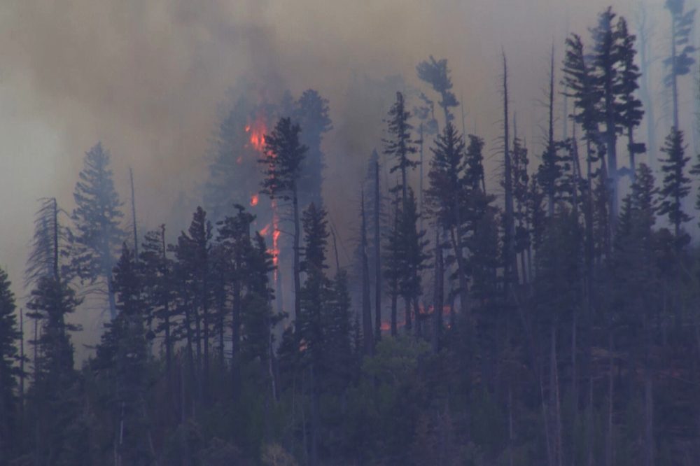
The pre-dawn accident occurred on May 14 in the rugged Capitan Mountains near Ruidoso. The impact triggered a wildfire that scorched the heavily forested area for weeks before it was fully contained on June 12, having burned 48.4 square miles — or 125.4 square kilometers — of terrain.
The National Transportation Safety Board issued a preliminary report on the incident Wednesday, outlining the GPS difficulties the crew experienced. However, investigators say the definitive cause of the crash won’t be established until their final report is completed sometime next year.
Aviation professionals say the pilots had other options available to them and should have been able to land safely without GPS, either by using ground-based navigation systems or by flying visually. Still, GPS has become the go-to tool for pilots because of its exceptional precision.
Retired airline pilot John Cox, who now serves as CEO of Safety Operating Systems, said the GPS failure alone shouldn’t have been fatal. “The loss of GPS should not result in the loss of an airplane, so there’s got to be more to it than that,” he said.
According to the NTSB, when the crew of the plane — operated by Trans Aero MedEvac — began experiencing navigation difficulties, air traffic controllers stepped in and gave them directional headings to help align them for an approach using the airport’s instrument landing system. At least three other aircraft in the area reported similar GPS issues around the same time.
At one point, controllers even reached out to the military and had the jamming temporarily suspended. But shortly before the crash, the pilots radioed that they could see the airport and intended to land visually. Controllers then gave the military clearance to resume jamming.
Cox questioned why the crew flew into the mountain if they had visual contact with the runway. “If you can see the runway, you can see the mountain. Why would you fly into it?” he asked, noting that even with the new details, many questions remain unanswered.
The Federal Aviation Administration had published a Notice to Airmen ahead of time alerting pilots to the planned GPS signal jamming in the area. Aviation safety expert Steve Arroyo said the medevac crew should therefore have been ready to navigate using alternative systems.
Arroyo, a longtime former pilot for United Airlines, acknowledged why pilots prefer GPS in challenging terrain. “GPS can bring you in precisely with a margin of safety that’s required and bring you down for landing. But if you don’t have GPS, you can’t make that approach within those margins and you may drift outside using conventional navigation,” he explained.
He added that once the pilots chose to attempt a visual approach, they assumed full responsibility for avoiding any obstacles between them and the runway.
The NTSB reported that the aircraft descended to 9,400 feet — about 2,865 meters — as it neared the airport, then climbed several hundred feet before striking a mountainside at 9,950 feet, or roughly 3,000 meters. The point of impact was approximately 230 feet below the Capitan Mountains Summit Radio Facility.
Trans Aero MedEvac has been serving southeastern New Mexico and west Texas since 1966. The four victims were identified as pilots Keelan Clark and Ali Kawsara, both with Generation Jets, and flight nurses Jamie Novick and Sarah Clark, both with Trans Aero MedEvac. The plane had been traveling from Roswell Air Center to Sierra Blanca Regional Airport when it went down.
Ruidoso, a mountain community with a year-round population of under 8,000, sits at the foot of south-central New Mexico’s Sierra Blanca range, surrounded by Lincoln National Forest and remote, forested landscape.