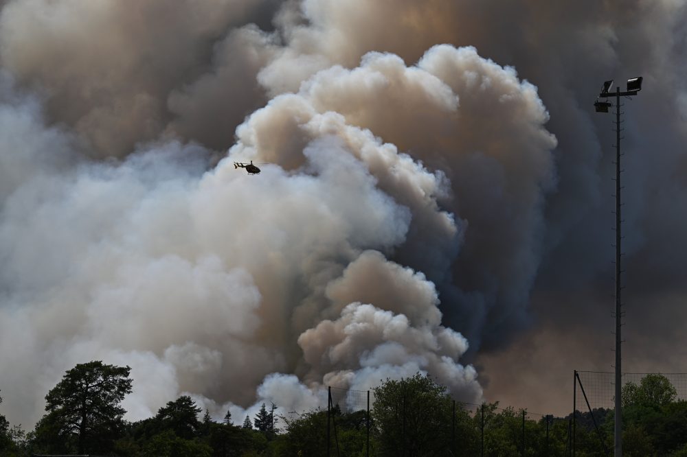

PARIS (AP) — A wildfire raging in southwest France became so ferocious that its towering smoke column transformed into a full-blown thunderstorm, generating lightning bolts that struck the ground and sparked new fires well beyond the original burning area, according to French officials.
In short, the fire was no longer just being driven by the weather — it was creating its own. The massive storm cloud also unleashed violent, unpredictable winds capable of pushing the flames in entirely new directions.
The phenomenon is known as a pyrocumulonimbus, or pyroCb. It is extremely rare in Europe and far more commonly seen in North America and Australia, where it only occurs during the most extreme fire events. France’s national firefighters federation stated it had never documented one within the country before this event.
The fire broke out near Saumos on July 22 and has since scorched more than 420 square kilometers — roughly 162 square miles — of forests and scrubland. More than 240 homes have been damaged or destroyed, and approximately 220,000 residents in the Gironde region have been forced to flee.
About two days after the fire started, at around 6:20 p.m. on Friday, the local fire and rescue service confirmed the formation of a pyrocumulonimbus. The cloud weakened during the overnight hours as humidity increased, but then reformed on several additional occasions.
Time and again, intense heat and smoke surged skyward, building into a massive, dark thundercloud crackling with electricity and glowing from within.
Theodore M. Giannaros, a fire meteorologist at the National Observatory of Athens, offered this explanation: “Imagine a campfire so large and hot that the smoke rising off it turns into a storm-like cloud. That is a pyroCb — a storm cloud born from the intense heat that a wildfire produces.”
But sheer fire size alone isn’t enough to create one. Giannaros explained there is no specific temperature threshold that triggers formation. Instead, the right atmospheric conditions are required — the same kind that produce dry thunderstorms — with extremely hot, dry air at ground level and cooler, more humid air higher up.
Smoke-laden, moisture-filled hot air rises rapidly from the flames. As it climbs and cools, water vapor condenses around ash particles. Higher up, above the freezing point, water droplets turn to ice crystals. When those crystals collide, they separate electrical charges — just like in a regular thunderstorm.
Beneath this self-generated storm sits a landscape already primed to burn. The cloud then amplifies the very disaster that created it. Rising air draws powerful winds toward the fire, while downdrafts send gusts slamming back to the surface. These shifting winds can redirect the flames, split them into multiple fronts, or send them charging off in a completely new direction.
“It’s a feedback loop, not a one-way effect,” Giannaros said. “Once it forms, the cloud becomes its own weather system, sitting on top of the fire and making it harder to predict.”
These systems can also generate spinning columns of flame. Giannaros describes a fire whirl as essentially a dust devil made of fire and heat rather than dust. True fire tornadoes are rarer, though one struck Redding, California, during the 2018 Carr Fire — packing winds equivalent to an EF-3 tornado and killing a fire inspector.
For firefighters on the ground, the dangers are severe. Escape routes can vanish in an instant as new outbreaks flare up behind crews and their equipment. Direct attacks on the fire may become impossible, forcing teams to pull back and focus on protecting communities instead. The greatest danger, Giannaros said, is a fire moving faster than evacuation efforts can keep up with.
Until now, pyroCbs have been largely an Australian and North American occurrence. Canada alone set a record with 142 of them in 2023. Portugal recorded one during its deadly 2017 fire season. France has now been added to that list.
Europe is warming faster than any other continent — at roughly twice the global average rate since the 1980s, according to the EU’s Copernicus Climate Change Service and the World Meteorological Organization. Heat waves are becoming more frequent and severe, and drought is spreading across southern Europe, effectively turning forests into ready fuel. Hotter, drier conditions create more opportunities for extreme fires to generate these storm clouds, Giannaros noted, though scientists still do not have enough long-term data to confirm a clear trend. A European research initiative called ROSETTA is working to fill that knowledge gap.
The most widespread misconception, Giannaros said, is that the cloud is simply a byproduct of the fire. In reality, as long as it hovers above the flames, it is actively influencing where the fire spreads next.