Delaware State Police have identified the victim who was found deceased in Lincoln on July 31, 2022 as Jose Santiago-Zamora Jimenez, 40, of Charlotte, North Carolina.
.
The Delaware State Police Homicide Unit is currently conducting a criminal investigation in the Lincoln area that began on Sunday morning.
.
On July 31, 2022, at approximately 1:30 a.m., troopers responded to the area of Staytonville Road west of North Union Church Road for a report of a subject lying near the roadway. Troopers arrived on-scene and discovered an unknown male subject deceased at this location. The male subject has yet to be identified, and the investigation is still ongoing at this time.
.
The Delaware State Police Homicide Unit is actively investigating this incident. Detectives are asking anyone with information regarding this case to contact Detective A. Bluto by calling 302-741-2859. Information may also be provided by sending a Private Facebook Message to the Delaware State Police, by contacting Delaware Crime Stoppers at 1-800-TIP-3333, or via the internet at www.delawarecrimestoppers.com.
Milton Ellendale Highway approaching the intersection at Mulberry Street
Delaware State Police are investigating a fatal motor vehicle collision that occurred in Milton on Saturday morning.
.
On July 30, 2022, at approximately 7:04 a.m., a silver 2014 Toyota Corolla was traveling eastbound on Milton Ellendale Highway approaching the intersection at Mulberry Street. At the same time, a gray 2016 Chevrolet Colorado was traveling westbound on Milton Ellendale Highway approaching the same intersection. The Colorado began turning left onto southbound Mulberry Street and entered the path of travel of the Corolla. As a result, the front left of the Chevrolet struck the left side of the Toyota in the intersection. This caused both vehicles to rotate counterclockwise, with the Corolla coming to rest in a grassy area off the south edge of the roadway and the Colorado coming to rest in the eastbound lane of Milton Ellendale Highway.
.
The operator of the Colorado, a 24-year-old male from Lewes, DE, was properly restrained and was not injured during the collision. The driver of the Corolla, a 20-year-old female from Woodbridge, Virginia, was properly restrained. She was transported via ambulance to an area hospital where she was later pronounced deceased. Identification of the victim is pending notification to the next of kin. The front-right passenger of the Toyota, a 28-year-old male from Hyattsville, Maryland, was properly restrained and was transported to an area hospital, where he was treated for non-life-threatening injuries. The rear-left passenger of the Corolla, a 19-year-old female from Woodbridge, Virginia, was properly restrained and was airlifted via helicopter to an area hospital in serious but stable condition. The rear-right passenger of the Toyota, a 20-year-old male from Woodbridge, Virginia, was properly restrained and was not injured.
.
No other vehicles were involved in this incident. The roadway was closed for approximately 3.5 hours while the collision was being investigated and cleared.
The Delaware Department of Natural Resources and Environmental Control is hosting the 35th annual Delaware Coastal Cleanup on Saturday, Sept. 17 from 9 a.m. to noon at 41 sites statewide to help keep the state’s beaches and waterways free of trash. Volunteers are encouraged to sign up for the one-day coordinated event when online volunteer registration opens on Monday, Aug. 1.
.
In addition, Delawareans and visitors are invited to join the month-long campaign starting Sept. 1 to clean up neighborhoods, green spaces and waterways throughout the state on days, times and at locations of their choice. The coordinated event and month-long campaign support Governor John Carney’s Keep DE Litter Free initiative.
.
“In 2019, we launched the Keep DE Litter Free initiative with the goal of building stronger communities and working together to keep our state beautiful by keeping our coastlines and outdoor spaces clear of litter,” Governor Carney said. “I thank our other state and local partners who plan and support the Delaware Coastal Cleanup, and I encourage all Delawareans to participate on cleanup day – and all year round.”
.
“DNREC encourages all Delawareans and visitors to make time to help keep our beaches, waterways and wetlands clean and free of trash throughout the year,” said DNREC Secretary Shawn M. Garvin. “The Coastal Cleanup is a great reminder that volunteers of all ages can make a difference, whether they sign up for the Sept. 17 statewide cleanup event or choose their own time, date and place to pick up trash.”
.
For the Sept. 17 coordinated cleanup, volunteers should sign up by Wednesday, Aug. 31 for their choice of sites through the Coastal Cleanup page at de.gov/coastalcleanup. Site captains with supplies will be on site to sign in volunteers and provide trash bags and directions. Although gloves, paper data cards and pencils will be available upon request, volunteers are encouraged to bring their own gloves and to use the online Coastal Cleanup reporting tool, when it goes live Sept. 1, to share their findings. Walkups are not encouraged due to volunteer site capacity limitations.
.
Find ideas about how to get involved in the 2022 Delaware Coastal Cleanup on Facebook and Twitter. Volunteers in both the coordinated event on Sept. 17 and the month-long campaign can post photos on facebook.com/DelawareDNREC for a chance to win a 2023 Delaware State Parks pass and a prize bag. Volunteers can post photos as often as they like throughout the month, with each photo counting as a one entry. All volunteers should also report their findings and are invited to share photos through the Coastal Cleanup page. Results will be updated during all month long and will appear on an interactive map.
.
Last year, nearly 600 volunteers filled about 400 bags, cleaning up 5,500 pounds of trash from waterways, wetlands and other natural areas. The top five trash items collected were: 7,671 cigarette butts; 2,921 plastic and glass beverage bottles and cans; 1,785 food containers; 846 plastic bags; and 381 balloons.
.
Cleaning up locally makes a big difference statewide and keeps trash from entering waterways and making its way to beaches and beyond. DNREC suggests several ways to help make a difference all year long:
Be proactive by picking up trash near your home to keep your neighborhood clean.
Follow a carry-in/carry out plan and take all trash with you when visiting outdoor spaces, like Delaware State Parks, DNREC wildlife areas, Delaware National Estuarine Research Reserve locations, and county or local parks.
Pack a bag and rubber gloves when you take a walk, go for a hike, go hunting or fishing, etc., to collect and carry out trash you find along the way.
Recycle applicable items through in-home recycling or designated drop-off locations. Learn more at de.gov/recycling.
DNREC reminds everyone to wear gloves when picking up trash, wash hands thoroughly after cleanup activities, and follow all recent public area protocols, including the most current COVID-19 guidance.
Delaware State Police are investigating a fatal motor vehicle collision that occurred in the Millsboro area on Wednesday afternoon.
.
On July 27, 2022, at approximately 3:14 p.m., a white 2019 Kia Optima was traveling eastbound on Mount Joy Road approaching a moderate left curve east of Cannon Road. For unknown reasons, the operator of the Kia failed to negotiate the curve, and the Kia exited the south edge of Mount Joy Road and continued traveling eastbound until it struck a utility pole off the roadway. After striking the pole, the Kia overturned onto its roof and caught fire.
.
The operator of the Optima, a 27-year-old male from Milford, DE, was not properly restrained. He was transported by ambulance to an area hospital, where he was treated for non-life-threatening injuries. The passenger of the vehicle sustained extensive thermal injuries and was pronounced deceased at the scene. The victim was turned over to the Office of the Medical Examiner for identification confirmation.
.
No other vehicles were involved in this incident. The roadway was closed for approximately 3.5 hours while the collision was being investigated and cleared.
.
The Delaware State Police Troop 7 Collision Reconstruction Unit continues to investigate this incident. Troopers are asking anyone who witnessed this collision to please contact Corporal J. Smith by calling 302-703-3267. Information may also be provided by sending a Private Facebook Message to the Delaware State Police, by contacting Delaware Crime Stoppers at 1-800-TIP-3333, or via the internet at www.delawarecrimestoppers.com.
Delaware State Police Troop 7 is issuing a Gold Alert for 59-year-old Wendy Kovin of Rehoboth Beach, Delaware. Wendy was last contacted in the early morning hours of July 28, 2022, in the Rehoboth Beach area. Attempts to contact or locate Wendy have been unsuccessful, and there is a concern for her safety and well-being.
.
Wendy is described as a white female, approximately 5’5” tall, 200 lbs., with brown hair and blue eyes. She has an unknown clothing description.
.
Anyone with information regarding Wendy’s whereabouts can contact Delaware State Police Troop 7 by calling 302-644-5020 or dialing 9-1-1. Information may also be provided by sending a Private Facebook Message to the Delaware State Police or contacting Delaware Crime Stoppers at 1-800-TIP-3333 or via the internet at www.delawarecrimestoppers.com.
The Dover Police Department is investigating a shooting that injured a 25-year-old male on Wednesday evening. At approximately 9:58 p.m., officer responded to the Cannon Mills apartment complex on Katrina Way for a report of shots fired. When officers arrived, they located the male victim with a gunshot wound to his leg. The victim was transported by ambulance to Bayhealth Kent Campus for treatment for non-life threatening injuries. The victim advised detectives that he was walking to his vehicle from his apartment when he was approached by an unknown black male that was wearing a black ski mask. The suspect displayed a handgun and fired multiple shots, striking the victim in the back of his leg. The victim stated that the suspect fled in a blue Chevrolet Silverado.
.
If you wish to provide information on this case or other criminal activity, please contact the Dover Police Department at (302)736-7130. Callers may remain anonymous. Tips may also be submitted to law enforcement through Delaware Crime Stoppers at 800-TIP-3333 or online at delaware.crimestoppersweb.com; a cash reward is possible for information leading to an arrest.
Delaware State Police have arrested Francis Phillips (no photograph available), 31, for theft of a motor vehicle following an incident Tuesday night.
.
On May 26, 2022, at approximately 6:04 p.m., troopers responded to Traders Joe’s located at 5605 Concord Pike, Wilmington for a stolen vehicle. Investigation determined the victim dropped her key fob to her 2020 Buick Enclave in the parking lot as she entered the store. Upon returning to her vehicle, it was no longer in the parking space. The suspect located the dropped key fob and fled the parking lot in the stolen vehicle. Through investigative means troopers located the stolen Buick Enclave on Kennett Pike in the area of Valley Way, Wilmington and initiated a traffic stop. The operator and sole occupant identified as Francis Phillips was taken into custody without incident.
.
Phillips was transported back to Troop 1 and charged with the following crimes:
Theft of a Motor Vehicle (Felony)
Phillips was arraigned in Justice of the Peace Court # 11 and released on his own recognizance.
An emergency dredging project is set to begin and be completed by the end of August to restore navigability in the Murderkill River, the Delaware Department of Natural Resources and Environmental Control announced today. Permitted by and with modification approvals from the U.S. Army Corps of Engineers and DNREC regulators, the project calls for removing approximately 52,000 cubic yards of sediment from the river’s navigation channel. DNREC will then make beneficial reuse of the dredged sand to nourish up to 1,000 feet of eroding shoreline at South Bowers Beach.
.
Funding for the $2.3 million project comes from appropriations to DNREC made under fiscal year 2022 and 2023 Bond Bills, both of which named the Murderkill River as a dredging priority.
.
“This important state-funded dredging project in the Murderkill River will restore navigability of the channel while bolstering shoreline resiliency in South Bowers,” said DNREC Secretary Shawn M. Garvin. “It’s a win-win in two critical DNREC areas of responsibility: navigable waterways and infrastructure support. Thanks to our partners – the U.S. Army Corps of Engineers, the town of Bowers and the South Bowers Volunteer Fire Company – for working with us to bring a much-needed dredging project to fruition.”
.
U.S. Senator Tom Carper (D-Del.), chair of the Environment and Public Works Committee, worked with the Army Corps of Engineers to ensure this project could begin.
.
“After working to secure the necessary federal permits from the Army Corps of Engineers, I’m so glad that this project will now be able to begin and restore the Murderkill River to its full potential,” said Senator Carper. “In the Senate, I’m leading the effort to pass bipartisan legislation that would support navigability in our waters for years to come. Enacting this legislation will ensure towns across our state can better access the help they need to maintain their infrastructure.”
.
The Murderkill River is a federally-authorized navigation project that requires periodic dredging to maintain the safety and navigable access to the river, critically important to commercial and emergency vessels as well as recreational boating. The river forms the southern boundary of the Town of Bowers – a popular boating area with its docks, DNREC Division of Fish and Wildlife-owned boat launch and large parking area – before flowing into the Delaware Bay.
.
In early 2022, DNREC removed sand from the Murderkill Inlet’s navigation channel but was limited by having to use a land-based excavator, and navigation continued to be challenge at low tide, especially in the mile-long approach channel to the Inlet. Nautical dredging equipment to be deployed next month will deepen the channel. An onshore staging area, made possible through a temporary construction easement agreement between DNREC and the South Bowers Volunteer Fire Company, will help facilitate the project. Dredging will be carried out by Cottrell Contracting Corp. of Chesapeake, Va., with almost a century-long record of Eastern Seaboard infrastructure dredging.
.
“Nourishing the South Bowers shoreline is a vitally important defense of the coastal community against extreme weather, an impact of climate change,” said Jesse Hayden, DNREC Shoreline and Waterway Management Section administrator. “The beach-quality sand from this latest dredging project will be used to extend the area of an earlier beach replenishment project that also utilized dredged sand from the Murderkill’s navigation channel.”
.
With the project expected to start on or about Aug. 1, the U.S. Coast Guard soon will give notice for mariners to exercise caution and maintain safe distance from the dredging activity – to include floating and submerged pipelines in the Murderkill, and the dredge and support vessels in the area. The USCG also advises that commercial fishing nets, crab pots and other structures removed from the dredging area before work begins.
The Dover Police Department arrested Elyas Tilghman (22) on firearms offenses during a traffic stop on Sunday night. At approximately 11:03 p.m., officers stopped Tilghman in the area of North DuPont Highway and College Road for a motor vehicle violation. During the stop, officers could smell a strong odor of marijuana coming from the vehicle. Tilghman told officers that there was marijuana in the vehicle and later admitted to having a handgun inside of the vehicle as well. During a search of the vehicle, officers located 4.3 grams of marijuana and a .38 caliber revolver under the drivers seat of the vehicle.
.
Tilghman was released on a $6,040 unsecured bond on the following offenses: -Possession of a Firearm by Person Prohibited (drug possession) -Carry Concealed Deadly Weapon -Possession of Marijuana (civil) -Drug Paraphernalia -Traffic Offenses
Governor Carney signed multiple pieces of legislation on Monday related to maternal and infant health aimed at decreasing infant and maternal mortality and expanding services to communities across the state. The series of legislation will improve health outcomes for families and infants throughout Delaware.
.
“This package of legislation is important for our community,” said Governor Carney. “Every child deserves a first chance to succeed and every mother and family should feel supported throughout and after a pregnancy. These bills will help address infant and maternal mortality in our community and expand services to families across the state. Thank you to Representative Minor-Brown, Senator Pinkney and other members of the General Assembly for their leadership on these pieces of legislation. Thank you to the health care providers and the advocates for the work they do every day.”
.
The United States has one of the highest rates of maternal mortality among high-income countries and wide disparities by race that have been documented since rates separated by race were first published in 1935.
.
“As a nurse and a Black woman, I am extremely aware of the maternal and infant health issues affecting Delaware families, particularly Black mothers and babies. I personally experienced preventable complications during both of my pregnancies, as an 18-year-old and as a 30-year-old registered nurse,” said Representative Melissa Minor-Brown, who was the lead House sponsor of all six bills. “Black women made up one of every four women giving birth in Delaware between 2011 and 2018, but they made up half of the mothers who died in childbirth. These are more than statistics; they are mothers and children who leave behind loved ones. These new laws are designed to help all Delaware mothers and infants, to improve their outcomes and increase their chances for a successful and healthy pregnancy, birthing process and postpartum. Taken together, these laws will make a huge impact on Delaware families across the state by breaking down barriers to vital healthcare treatment and removing other obstacles that mothers and families have faced.”
.
“I am incredibly proud of this package of legislation, both as a Black woman and as a social worker. All too often, I see patients without adequate insurance who can’t afford to keep up with their recommended care plans once they are discharged,” said Senator Marie Pinkney. “I have seen patients who have been discriminated against based on their race, their gender identity and their substance use. I have seen the difference in outcomes between birthing mothers who had access to a doula and those who did not. As lawmakers, we must do everything in our power to make it easier for new mothers to focus on birthing healthy children and then to advocate for their prenatal and postpartum needs. These bills will remove barriers and reduce disparities for all future generations of Delaware mothers.”
.
House Bill 340 revamps the Child Death Review Commission to include more focus on maternal concerns. The commission will be renamed the Maternal and Child Death Review Commission to reflect its existing dual focus. The definition of “maternal death” will also be updated and the Commission would reflect diverse membership that would include a midwife and one maternal and one child advocate from statewide non-profit organizations. In an effort to be transparent, the group will be required to publicly post its draft report and accept written public comment.
.
“The Child Death Review Commission is a critical function of our state’s judiciary,” said Senate Majority Leader Bryan Townsend. “By expanding its scope to focus on maternal issues, we may better understand some of the social determinants of health that affect pregnancy and the following months of postpartum recovery.”
.
House Bill 344(S) requires the Delaware Perinatal Quality Collaborative to establish a subcommittee to develop bias and cultural competency training for healthcare employees. The subcommittee will develop training guidelines designed for use in all healthcare fields and shall release the initial guidelines by July 1, 2023. The subcommittee will review data every year thereafter and revise the guidelines as necessary.
.
“Delaware has world class health care providers, but they are also human. The only way to build a health care system that works for everyone is to ensure that our providers are provided the opportunity to grow, to fill knowledge gaps, and to address biases that they may not even be aware they hold,” said Senator Sarah McBride. “I’m proud to have supported the entire Momnibus package, but I’m particularly thrilled to have joined with Rep. Minor-Brown on HB 344 to empower more providers with the information and resources they need to alleviate patient fears and offer the best possible care to every patient no matter their background.”
.
House Bill 342 expands existing restrictions on the use of restraints on women who are giving birth or in labor to include pregnant women and those in the 13-week post-partum period.
.
House Bill 345 ensures pregnant women or women who have given birth within the past six weeks who are subject to the custody of the Department of Corrections at Level IV or V have access to midwifery and doula services by requiring the department to make reasonable accommodations for provision of available midwifery or doula services.
.
House Bill 343 requires the Division of Medicaid and Medical Assistance to present a plan to the General Assembly by November 1 for coverage of doula services by Medicaid providers. The services will be provided by a trained doula designed to provide physical, emotional, and educational support to pregnant and birthing persons before, during, and after childbirth. This will include support and assistance during labor and childbirth, prenatal and postpartum support and education, breastfeeding assistance, and parenting education.
.
House Bill 234 requires the Division of Medicaid and Medical Assistance to extend Medicaid postpartum coverage to 12 months from the end of pregnancy through the state plan amendment option created by the American Rescue Plan Act of 2021.
UPDATE: Delaware State Police have identified the victim who died during a fatal pedestrian crash that occurred on July 24, 2022, in the Dewey Beach area as Sidney Wolf, 43, of Clarksburg, Maryland.
Delaware State Police are investigating a fatal pedestrian crash that occurred early Sunday morning on southbound Coastal Highway (Route 1) in the area of Anchors Way, Dewey Beach, DE.
On July 24, 2022, at approximately 1:44 a.m., the victim and five of his friends hired a “Lyft” driver to pick them up in Dewey Beach and transport them back to their residence in Bethany Beach. As the group was traveling southbound on Coastal Highway all in the same vehicle, a disagreement occurred between the group and the Lyft operator. The Lyft operator terminated the ride and stopped in the middle of the southbound left lane and demanded all six passengers exit the vehicle. At this time, a 2016 Toyota Corolla, operated by a 27-year-old male was traveling southbound on Coastal Highway in the left lane approaching the stopped Lyft vehicle (possibly a white Honda Pilot). As the operator changed lanes to avoid striking the rear of the Lyft vehicle, he failed to see the pedestrian who had just exited the right rear passenger seat and was standing in the roadway. As a result, the left front of Corolla struck the pedestrian. After impact, the Corolla immediately pulled over on the southbound shoulder and came to a controlled stop. The Lyft vehicle fled southbound on Coastal Highway immediately after the crash.
The 43-year-old male pedestrian victim of Clarksburg, MD was pronounced deceased at the scene. Identification of the victim is pending notification to the next of kin.
The other 5 passengers were not injured after exiting the Lyft vehicle.
The roadway was closed for approximately 4 hours while the collision was investigated and roadway cleared.
The operator or the Lyft vehicle has not been identified yet and remains under investigation
West Nile Virus (WNV) has been detected in Delaware the first time for 2022 in a sentinel chicken, the Delaware Department of Natural Resources and Environmental Control announced today. This initial finding was from a sentinel chicken station in southern New Castle County sampled by the DNREC Division of Fish and Wildlife Mosquito Control section and confirmed by the Delaware Public Health Laboratory on July 19. While there have been no reported WNV cases in humans this year in the state, Delawareans are reminded that the possibility of contracting mosquito-transmitted diseases, including WNV and Eastern Equine Encephalitis (EEE), will continue until colder autumn temperatures in mid-October or later.
Blood samples are collected by the Mosquito Control section each week from early July into October from the state’s outdoor-caged sentinel chickens that are humanely housed and handled at 20 monitoring stations statewide. The blood samples are tested for WNV and EEE antibodies by the Delaware Public Health Laboratory. Sentinel chickens bitten by mosquitoes carrying WNV or EEE develop antibodies to these diseases but are otherwise unaffected. Mosquitoes can transmit both WNV and EEE to humans and horses.
Most people infected with WNV do not develop symptoms, but about 20% can develop a mild illness, including fever, body and muscle aches, headache, nausea, vomiting, and rash symptoms. A small number of people can develop serious illness involving neurological problems, paralysis, and possibly death. EEE is not as prevalent as WNV but can present more severe symptoms in humans and horses.
The public is reminded to take common-sense precautions to avoid mosquito bites, including wearing long-sleeved shirts and long pants when outdoors in mosquito-prone areas, applying insect repellent containing 10 to 30% diethyltoluamide (DEET) in accordance with label instructions, and avoiding mosquito-infested areas and at times of peak mosquito activity around dusk, dawn and at night.
According to the Delaware Department of Agriculture (DDA), there were no equine cases of WNV or EEE in 2021. With the detection of WNV in a sentinel chicken this early in the season, the state veterinarian urges horse owners to contact their veterinarians as soon as possible to vaccinate horses and other equines against WNV and EEE. Both vaccines are highly effective in minimizing disease and may be the reason why Delaware had no equine cases in 2021. Horses that have been vaccinated in the past will need an annual booster shot. Neither disease has a specific drug treatment, and infections in horses are fatal in 70 to 90% of EEE cases and 30% of WNV cases.
Spraying to reduce mosquito populations in areas where WNV or EEE is detected may be initiated by the DNREC Mosquito Control section as warranted, based on factors to include mosquito population levels and mosquito species present in affected areas. To reduce mosquito-breeding habitat and chances of disease transmission, residents should drain or remove outdoor items that collect water, such as discarded buckets or containers, uncovered trashcans, stagnant birdbaths, unprotected rain barrels or cisterns, old tires, upright wheelbarrows, flowerpot liners, depressions in boat tarps, clogged rain gutters, corrugated downspout extenders, and unused swimming pools.
Horse owners can take several additional steps in the barn and around the farm to help protect horses from mosquito bites. Horses should be kept inside at dawn and dusk, peak hours for mosquito activity. Topical insect repellents labeled for use on horses may be applied. Wind generated by fans installed in horse stalls can also help deter mosquitoes. Water troughs or buckets should be emptied, cleaned, and refilled every 2-3 days to remove mosquito eggs or larvae.
The Dover Police Department arrested a 25-year-old Dover man for DUI and other offenses after fighting with an officer during a crash investigation. Tony Williams (25) was contacted by a Dover officer in the area of South DuPont Highway and East Division Street at approximately 9:04 p.m. on Thursday, July 21st. Williams was contacted after officers responded to a report of a crash between two vehicles in the area. Williams had attempted to from East Division Street onto the southbound lanes of S. DuPont Highway, when he failed to turn properly and entered the northbound lanes, striking another vehicle that was stopped at a red light. Williams then traveled over a concrete median and drove onto a sidewalk alongside South DuPont Highway (southbound). During the investigation, it was determined that Williams was under the influence of alcohol and was acting belligerent with officers. When an officer attempted to take Williams into custody, he attempted to physically fight with several officers, with one sustaining minor injuries (lacerations) during the incident.
Officers later found three grams of Dilaudid pills, small amount of marijuana, and three grams of opium pills. A blood search warrant was obtained for WIlliams and later executed at Bayhealth Kent Campus. Williams was committed to SCI on an intoxication hold and is pending arraignment on the following offenses:
-Assault 2nd Degree on Law Enforcement -Resisting Arrest with Force/Injure Officer (Felony Resisting) -Possession with Intent to Deliver Controlled Substance -Drug Paraphernalia -DUI -Various traffic offenses
Today, July 21, 2022, at approximately 4:30 a.m., the Delaware City Refining Company experienced an outage at the carbon monoxide boiler on the fluid coking unit at the Delaware City refinery. The Delaware Department of Natural Resources and Environmental Control has learned that the outage caused excess emissions of carbon monoxide (CO), sulfur dioxide, hydrogen sulfide, ammonia, hydrogen cyanide and particulate matter. DNREC continues to monitor the situation at the refinery, and does not expect the release to impact public health and safety.
While the refinery’s excess emissions remain visible into the afternoon, the DNREC Division of Air Quality monitoring station near Delaware City has not shown elevated levels of particulate matter resulting from the CO boiler outage. DNREC is continuing to assess and monitor the situation as the Delaware City facility works to bring the CO boiler back online – projected for early afternoon today.
DNREC also is investigating the refinery’s unpermitted release of pollutants and will take appropriate follow-up action, to include enforcement if warranted.
Governor John Carney announced today that seven women were selected for induction into the Delaware Women’s Hall of Fame for 2022. Out of the more than 50 applicants received by the Office of Women’s Advancement and Advocacy and the Delaware Women’s Hall of Fame Committee, the Committee chose seven of the top nominees who have made significant contributions in Delaware.
This year’s inductees include:
Anne Canby, a pioneer in transportation as the first woman to lead the Delaware Department of Transportation (DELDOT) in 1993 and as Deputy Director of Transportation during the Carter Administration.
Alice Dunbar-Nelson, a late suffragist, poet, activist, and educator at Howard High School in Wilmington.
Carolyn Fredericks, the Executive Director of the Modern Maturity Center and longtime advocate for Delaware seniors.
Teri Quinn Gray, former DuPont scientist, and current Chief Operating Officer at the science-based crop protection company, Provivi, in California.
Ilona Holland, children’s educator with a focus on literacy. Has consulted on children’s educational TV programming, authored numerous children’s books, and is a partner with the Delaware State Library system.
Karyl Rattay, former Director of Delaware’s Division of Public Health, served during the COVID pandemic and holds the longest tenure in the role.
Aida Waserstein, former judge of the Family Court of Delaware. Has also written several books with the goal of helping foster children by telling her own immigrant story.
“It is our honor to recognize these women and their positive impact on our community,” said Governor Carney. “I congratulate them on their selection and thank the Delaware Women’s Hall of Fame Committee for choosing another round of remarkable Delaware women for induction into the Hall of Fame.”
“With an incredible pool of applicants this year, the committee had a difficult time narrowing it down to this year’s class of inductees,” said Kay Keenan, Chair of the Delaware Women’s Hall of Fame Committee. “The diversity of women we’ve selected comprise an amazing group who have done so much for Delaware in so many different ways, and we are so pleased to be able to honor them in the fall.”
The Hall of Fame of Delaware Women was established in 1981 and is the oldest annual celebration of its kind commemorating Delaware women. Eligible women must have been born in Delaware or resided in the state for minimum of ten years.
“As a small state, it’s important to highlight the big achievements and myriad contributions of Delaware women both past and present,” said Melanie Ross Levin, Director of the Office of Women’s Advancement & Advocacy. “We encourage all Delawareans to learn more about the 2022 Delaware Women’s Hall of Fame inductees and consider nominating someone in the future.”
Inductees will be recognized at the 41st Annual Hall of Fame of Delaware Women Induction Ceremony. The event will be held this fall, with all details on the event and other Hall of Fame activities available in the coming months at de.gov/women.
View the biographies of the 2022 Honorees and all 160 inductees of the Delaware Women’s Hall of Fame here.
Delaware State Police have arrested 39-year-old Harry Reed of Wilmington, DE, for felony drug charges following a traffic stop in the Wilmington area on Wednesday night.
On July 20, 2022, at approximately 11:30 p.m., members of the Delaware State Police New Castle County Governor’s Task Force performed a traffic stop on a Buick Park Avenue traveling on S. Heald Street in the area of Peach Street with expired registration. A traffic stop was initiated, and contact was made with the operator and sole occupant, identified as Harry Reed. Upon contact the trooper immediately observed suspected drugs in the lap of Reed and he was taken into custody without incident. A subsequent search of the vehicle led to the discovery of approximately 13.6 grams of crack cocaine and approximately 16.04 grams of marijuana.
Reed was transported back to Troop 6 and charged with the following crimes
Possession With Intent to Distribute a Controlled Substance in Tier 2 Quantity (Felony)
Possession of a Controlled Substance in Tier 2 Quantity (Felony)
Possession of Marijuana
Expired Tags
Reed was arraigned by Justice of the Peace Court # 11 and committed to the Howard R. Young Correctional Institution on $15,002 cash bond.
President Joe Biden tested positive for COVID-19 Thursday morning, his office said.
Biden, who is fully vaccinated and received two boosters, has “very mild symptoms” and is taking Paxlovid, press secretary Karine Jean-Pierre said in a statement.
Jean-Pierre said an update will be provided every day as Biden “continues to carry out the full duties of the office while in isolation” at the White House.
Biden was scheduled to appear in Wilkes-Barre, PA this afternoon.
The Dover Police Department arrested Angelo Albarran (51) for a 3rd offense DUI following a single vehicle collision on Monday night. Officers responded to the 200 Block of West Division Street after Albarran struck a curb, utility pole, and a residence while operating a gold GMC Sierra. Albarran was transported to Bayhealth Kent Campus for treatment of minor injuries sustained in the crash and officers obtained a blood search warrant after Albarran showed signs of intoxication. Upon release from the hospital, Albarran was committed to SCI on a $5,600 secured bond on the following offenses:
-Third Offense DUI -Multiple Traffic Offenses
If you wish to provide information on this case or other criminal activity, please contact the Dover Police Department at (302)736-7130. Callers may remain anonymous. Tips may also be submitted to law enforcement through Delaware Crime Stoppers at 800-TIP-3333 or online at delaware.crimestoppersweb.com; a cash reward is possible for information leading to an arrest.
The Dover Police Department has arrested a suspect in the July 10th arson that occurred at a Target department store. Through the collection and examination of in-store surveillance footage and physical evidence from the store, Desmond Smith (26), was identified as the sole suspect in the arson. Smith set the fire as a diversion to steal a cart full of merchandise from the business. Detectives obtained an arrest warrant for Smith and executed a search warrant at his residence in the 900 Block of Whatcoat Drive at 11:00 a.m. on Monday, July 18th, 2022. Smith was taken into custody without incident and later committed to SCI on a $137,000 cash bond after being arraigned at Justice of the Peace Court #7 on the following offenses:
-Arson 1st Degree -Reckless Endangering 1st Degree (19x) -Criminal Mischief $5,000 or Greater -Shoplifting Under $1,500 -Wearing a Disguise During Commission of Felony
If you wish to provide information on this case or other criminal activity, please contact the Dover Police Department at (302)736-7130. Callers may remain anonymous. Tips may also be submitted to law enforcement through Delaware Crime Stoppers at 800-TIP-3333 or online at delaware.crimestoppersweb.com; a cash reward is possible for information leading to an arrest.
On Sunday, July 17, 2022, at 6:47 p.m., the Emergency Operations Center received a phone call for a shots-fired complaint on the southbound side of I-295, south of US 13. When troopers arrived on the scene, they learned that Kirby Richards was the passenger of a vehicle involved in a minor motor vehicle collision at that location. Kirby exited the vehicle and attempted to block traffic so the vehicles involved in the collision could move to the shoulder of the roadway. The victim, a 58-year-old male from Wilmington, Delaware, traveling in a vehicle not involved in the collision, was passing by the scene while Kirby was standing in the roadway. The victim attempted to drive around Kirby, at which time a verbal argument ensued between the two men. During the argument, Kirby returned to his vehicle and retrieved a firearm. Kirby then fired the weapon at the victim, which struck the victim’s vehicle approximately four times. The victim then fled onto I-495 northbound and contacted 911. Kirby remained on the scene and was taken into custody without incident. He was then transported to Troop 6, where he was charged with the following crimes:
Two counts of Reckless Endangering 1st Degree (F)
Possession of a Firearm During the Commission of a Felony (F)
Criminal Mischief Greater than $1000 (M)
Kirby was arraigned by the Justice of the Peace Court # 11 and committed to Howard R. Young Correctional Institute on a $33,000 secured bond.
Rehoboth Beach- On July 17, 2022, at approximately 11:32 a.m., troopers were dispatched to a wooded area near East Atlantic Apartments in reference to a death investigation. When troopers arrived, they observed the body of a male victim in a wooded area where homeless individuals are known to frequent. The victim was pronounced deceased on the scene, and the body was turned over to the Division of Forensic Science for an autopsy. This incident does not pose a threat to public safety. Next of kin notification is pending, so no additional details can be provided at this time.
If you or someone you know is a victim or witness of a crime or have lost a loved one to a sudden death and need assistance, the Delaware State Police Victim Services Unit/Delaware Victim Center is available to offer you support and resources 24 hours a day through a toll-free hotline 1-800-VICTIM-1. (1-800-842-8461). You may also email the Victim Services Unit at [email protected].
29-year-old Junior Velazquez-Morillo of Newark, DE
Delaware State Police have arrested 29-year-old Junior Velazquez-Morillo of Newark, DE on felony drug charges following a traffic stop that occurred on Thursday evening.
On July 14, 2022, at approximately 7:00 p.m., troopers on patrol observed a silver Hyundai Elantra parked in The Elms apartment complex in Newark. Troopers witnessed a hand-to-hand transaction occur between the operator of the Elantra and another subject in the parking lot. A traffic stop was initiated on the vehicle on Coventry Lane and contact was made with the operator, identified as Junior Velazquez-Morrillo. Troopers observed drug paraphernalia in plain view, and Velazquez-Morrillo was subsequently taken into custody at the scene without incident. A search of the Elantra led to the discovery of approximately 3.2 grams of cocaine and approximately 4.5 grams of suspected heroin and fentanyl.
Velazquez-Morrillo was transported to Troop 6 and charged with the following crimes:
Possession With Intent to Deliver a Controlled Substance in a Tier 2 Quantity (Felony) – 2 counts
Possession With Intent to Deliver a Controlled Substance (Felony) – 2 counts
Velazquez-Morrillo was arraigned by Justice of the Peace Court # 11 and committed to Howard R. Young Correctional Institution on $60,000 cash bond.
Delaware State Police have arrested 40-year-old Jaymes Gimbutas of Wilmington, DE for several criminal charges following two robbery investigations that began earlier this week.
On July 11, 2022, troopers responded to Twin Birds African Market located at 3616 Kirkwood Highway in Wilmington regarding a knife-point robbery. In this incident, an unknown male subject entered the business with a knife and demanded money from the cashier. Later on July 11, 2022, troopers responded to Roselle Liquors located at 2500 Kirkwood Highway in Wilmington regarding another knife-point robbery. In this case, an unknown male subject entered the store with a knife and demanded money from the employee.
Through investigative means, it was determined that Jaymes Gimbutas was the male suspect involved in both robberies. On July 14, 2022, Gimbutas was taken into custody at his residence without incident. Gimbutas was transported to Troop 6 and charged with the following crimes:
Robbery First Degree (Felony) – 2 counts
Possession of a Deadly Weapon During the Commission of a Felony (Felony) – 2 counts
Wearing a Disguise During the Commission of a Felony (Felony) – 2 counts
Gimbutas was arraigned by Justice of the Peace Court # 2 and committed to Howard R. Young Correctional Institution on $210,000 cash bond.
A Milton man has been arrested for felony theft after he allegedly stole hundreds of fishing rods, reels and other equipment from Lewes Harbour Marina over the last several years.
Thomas J. Serbin (51) was a longtime employee at Lewes Harbour Marina, serving the last two years as store manager. On July 2, Lewes Police received a complaint alleging Serbin had stolen a large number of items from the business.
Police obtained a warrant and searched Serbin’s home on July 12, when they found 115 fishing rods, 125 high-end fishing reels, more than 50,000 yards of high-end fishing line, hundreds of saltwater fishing lures and other tackle, and other fishing equipment and merchandise. The estimated value of the items is more than $100,000.
Serbin was charged with felony theft and released on bail.
The Attorney General’s Office is reviewing the case for an upgrade of charges. Police suspect, he was bartering and selling the items.
Lewes Police continue to investigate the case. Anyone who received property from Serbin is asked to contact Lewes Police at 302-645-6264 or Lewes Harbour Marina at 302-645-6227. Police say anything received that Serbin may have said was gifted to him or a promotional item from manufacturers is likely stolen.
The Dover Police Department has made an arrest in connection with the discovery of a body, later identified as Jorge Valladares (30), in the Saint Jones River on July 2nd, 2022. During the investigation, information was obtained that Valladares’ death was possibly the result of a motor vehicle accident. On June 22nd, 2022, officers from the Dover Police Department responded to East Water Street for a single vehicle crash that was approximately 225 off the roadway at 4:17 a.m. The crash involved a red 2013 Jeep Wrangler. While investigating the crash, the driver and a passenger provided conflicting information about the crash, to include the number of persons in the vehicle at the time of the crash, ultimately telling officers there were only two people inside the car. Officers checked the surrounding area and did not locate any additional evidence or persons.
Both the driver (Luis Coello, 30) and the 41-year-old male passenger were both transported to Bayhealth Kent Campus for treatment of non-life threatening injuries from the crash.
During the investigation, it was discovered that the crash had actually occurred on June 21st at 11:21 p.m. The first call to police did not occur until 4:17 a.m., nearly a 5 hour delay.
A review of evidence obtained from the vehicle and surveillance footage from nearby businesses showed that the Jeep Wrangler was traveling eastbound on Water Street, approaching a sharp left curve (in front of Del-One Federal Credit Union). The Jeep did not brake and drove over the curb, traveled down an embankment, turning over multiple times. Evidence obtained from the vehicle shows that none of the three occupants were wearing seatbelts. It is believed that Valladares was ejected from the vehicle and landed in the Saint Jones River. Autopsy results show that Valladares’ had traumatic head injuries as a result of the crash.
During the 5-hours between the crash and the first notification to police, Valladares’ body moved a significant distance as the result of the river’s current. Valladares’ body was located on July 2nd by a group of kayakers, approximately 197 meters from where he likely entered the river.
At no point in the investigation did the driver or passenger of the vehicle advised police that Valladares was also in the vehicle.
During the initial crash investigation, Cuello (30) was charged with Driving Under the Influence and additional traffic offenses.
As a result of the investigation following the discovery of Valladares’ body, Cuello was also charged with Vehicular Homicide 2nd Degree. Cuello was arrested in Newark without incident and committed to SCI on a $7,000 secured bond.
A mugshot of Cuello was not available at the time of release. Cuello is a resident of Newark, DE.
.MIDDLETOWN MICROBURST...

PEAK WIND ESTIMATED:	90 MPH
PATH LENGTH /STATUTE/:  2.5 MILES
PATH WIDTH /MAXIMUM/:   1.5 MILES
FATALITIES:             0
INJURIES:               0

START DATE:             JULY 12, 2022
START TIME:             5:36 PM EDT
START LOCATION:         5 MILES NW MIDDLETOWN, NEW CASTLE COUNTY, DELAWARE
START LAT/LON:          39.51/-75.78

END DATE:               JULY 12, 2022
END TIME:               5:40 PM EDT
END LOCATION:           4 MILES N MIDDLETOWN, NEW CASTLE COUNTY, DELAWARE
END LAT/LON:            39.51/-75.73

A MICROBURST OCCURRED ABOUT 5 MILES NORTHWEST OF MIDDLETOWN, DE IN
NEW CASTLE COUNTY AROUND 5:36 PM EDT. THE AREA OF DAMAGE WAS
CONFINED MAINLY TO A RESIDENTIAL AREA WEST OF US ROUTE 301 ALONG
CHURCHTOWN ROAD. SEVERAL TREES WERE UPROOTED IN THE AREA AND SOME
HOMES SUSTAINED SOME MINOR STRUCTURAL DAMAGE. THE WORST OF THE
STRUCTURAL DAMAGE INCLUDED A GARAGE DOOR BEING BLOWN OUT. IN THE
SAME RESIDENTIAL AREA, A PERSONAL WEATHER STATION MEASURED AN 87 MPH
WIND GUST ON CAZIER DRIVE AT 5:40 PM EDT.

THE STRONGEST WIND GUSTS RESULTING IN THE DAMAGE CAUSED BY THIS
SEVERE THUNDERSTORM HAVE BEEN ESTIMATED TO BE AROUND 90 MPH.
PUBLIC INFORMATION STATEMENT
NATIONAL WEATHER SERVICE MOUNT HOLLY NJ
445 PM EDT THU JUL 14 2022

...NWS DAMAGE ASSESSMENT FOR JULY 12TH, 2022 THUNDERSTORM WIND EVENT...

.DENTON-HOBBS-ANDREWSVILLE-FARMINGTON MACROBURST...

PEAK WIND ESTIMATED:	110 MPH
PATH LENGTH /STATUTE/:  18 MILES
PATH WIDTH /MAXIMUM/:   4 MILES
FATALITIES:             0
INJURIES:               1

START DATE:             JULY 12, 2022
START TIME:             7:22 PM EDT
START LOCATION:         1.5 MILES SW DENTON, CAROLINE COUNTY, MARYLAND
START LAT/LON:          38.86/-75.85

END DATE:               JULY 12, 2022
END TIME:               7:57 PM EDT
END LOCATION:           4 MILES E FARMINGTON, SUSSEX COUNTY, DELAWARE
END LAT/LON:            38.87/-75.50

A MACROBURST BEGAN AROUND 7:22 PM EDT ABOUT 1.5 MILES SOUTHWEST OF
DENTON, MD IN CAROLINE COUNTY ALONG THE CHOPTANK RIVER. THE FIRST
AREA IMPACTED BY THE MACROBURST WAS AT MARTINAK STATE PARK WHERE
NUMEROUS TREES WERE DAMAGED. ONE TREE FELL ONTO A CAMPING TRAILER IN
THE CAMPGROUND RESULTING IN ONE MINOR INJURY TO AN OCCUPANT. A
PERSONAL WEATHER STATION JUST NORTH OF THE STATE PARK MEASURED A 70
MPH WIND GUST. THE PARENT STORM TRAVELED EASTWARD AND IMPACTED THE
HOBBS, MD AREA THEN CROSSED INTO FAR SOUTHWESTERN KENT COUNTY IN
DELAWARE WHERE IT CONTINUED TOWARD THE ANDREWSVILLE, DE AND
FARMINGTON, DE AREAS. ALONG THIS PATH, NUMEROUS AREAS SUSTAINED
CONSIDERABLE TREE AND UTILITY POLE DAMAGE ALONG WITH SOME
STRUCTURAL DAMAGE. NUMEROUS TREES WERE UPROOTED OR SNAPPED AND SOME
UTILITIES POLES WERE SNAPPED. A FEW STRUCTURES SUSTAINED
CONSIDERABLE ROOF MATERIAL AND ROOF STRUCTURE REMOVAL, INCLUDING A
FEW BARNS, FARM OUTHOUSES, AND CHICKEN HOUSES. AN UNUSED GRAIN SILO
AND A RESIDENTIAL TV ANTENNA TOWER WERE COLLAPSED. ONE HOME HAD A
COUPLE WINDOWS BLOWN OUT. THE STORM CONTINUED EASTWARD INTO NORTHERN
SUSSEX COUNTY EAST OF US ROUTE 13 WHERE IT BEGAN TO WEAKEN
CONSIDERABLY BY 7:57 PM EDT.

THE STRONGEST WIND GUSTS RESULTING IN THE DAMAGE CAUSED BY THIS
SEVERE THUNDERSTORM HAVE BEEN ESTIMATED TO BE AROUND 110 MPH.
Delaware State Police Troop 4 is issuing a Gold Alert for 30-year-old Matthew Cornwell of Georgetown, DE. Cornwell was last seen on July 11, 2022 at approximately 9:00 a.m. in the Georgetown, DE area. Attempts to contact or locate Cornwell have been unsuccessful, and there is a concern for his safety and well-being.
Cornwell is described as a white male, approximately 5’09” tall, weighing approximately 140 pounds, with brown hair and blue eyes. Cornwell has the sides of his head buzzed and the rest of his hair pulled into a ponytail.
Anyone with information regarding Matthew Cornwell’s whereabouts is asked to contact Delaware State Police Troop 4 by calling 302-856-5850 or by dialing 9-1-1. Information may also be provided by sending a Private Facebook Message to the Delaware State Police, contacting Delaware Crime Stoppers at 1-800-TIP-3333, or via the internet at www.delawarecrimestoppers.com.
Delaware State Police have identified the victims who died during a fatal motor vehicle collision that occurred on July 11, 2022 in the New Castle area as Caitlyn Wilson, 16, of New Castle, DE; Beverly Weaver, 69, of Sun City, Florida; and Dennis Smith, 36, of Newark, DE.
The Delaware State Police Troop 2 Collision Reconstruction Unit continues to investigate this collision. Troopers are asking anyone who witnessed this collision to please contact Master Corporal J. Forester by calling 302-365-8485. Information may also be provided by sending a Private Facebook Message to the Delaware State Police, by contacting Delaware Crime Stoppers at 1-800-TIP-3333, or via the internet at www.delawarecrimestoppers.com.
Delaware State Police have arrested Calvin Samuels, 39, of Valley Stream, NY, for robbery following an incident in June.
On June 17, 2022, at approximately 1:43 p.m., troopers responded to the Wells Fargo bank located at 2450 Glasgow Avenue for an alarm activation. Upon their arrival it was discovered that the bank had just been robbed and the suspect had fled the scene. The ensuing investigation revealed that the suspect had entered the bank and presented a teller with a demand note. The teller surrendered money to the suspect, and the suspect exited the building and departed from the area in an unknown direction towards an unknown destination. No one was injured in this incident.
On July 12, 2022, the Newark Police Department located and arrested Calvin Samuels after a bank robbery at the TD Bank, located at 230 East Delaware Avenue, Newark. Through investigative means officers connected Samuels to a total of 8 bank robberies that occurred throughout New Castle and Kent Counties beginning in May 2022 within the city limits of Wilmington, Newark, Dover, and Middletown.
Samuels was transported to Newark police station where he was charged with the following crimes:
Robbery 2nd Degree (Felony) – 2 counts
Samuels was arraigned in the Justice of the Peace Court #2 and committed to the Howard R. Young Correctional Institution on $12,000 cash bond.
Delaware State Police are investigating a fatal motorcycle collision that occurred Tuesday night on Newport Gap Pike (Route 41) in Wilmington area.
On July 12, 2022, at approximately 9:17 p.m., a black 2016 Harley Davidson motorcycle was traveling southbound on Newport Gap Pike (Route 41). At this time, a white 2014 Ford F250 was traveling northbound on Newport Gap Pike approaching the driveway to a private residence. The Ford turned left attempting to enter the driveway, and directly into the path of the Harley. The motorcycle applied its brakes in an attempt to avoid the collision, but ultimately struck the right-side rear of the Ford. As a result of this collision the Harley traveled out of control into the northbound lane. A white 2015 Subaru Outback that was traveling northbound on Newport Gap Pike behind the Ford, struck the motorcycle causing it to be logged underneath it.
The operator of the Harley, a 30-year-old male of Cochranville, PA was ejected from the motorcycle and pronounced deceased at the scene. Identification of the victim is pending notification to the next of kin.
The operator of the Ford, a 58-year-old male of Wilmington, DE appeared to be under the influence of alcohol and a DUI investigation ensued. A preliminary state police investigation suggests alcohol was involved. The operator of the Ford and the operator of the Subaru were not injured in the collision.
Newport Gap Pike was closed in both directions between Loveville Road and Millcreek Road for approximately 4 hours while the crash was investigated, and the roadway cleared.
Governor Carney Announces Changes to Leadership Team
WILMINGTON, Del. — Governor John Carney on Wednesday announced changes to his leadership team in the Office of the Governor:
Sheila Grant, who has served as chief of staff since 2019, will leave the Governor’s office in August to serve in the White House as Special Assistant to the President and Senior Presidential Speechwriter. Before her tenure as chief of staff, Grant served as the Governor’s deputy chief of staff, and as chief of staff in Governor Carney’s congressional office and has been his primary speechwriter over the past decade. She was previously an aide for Senator Tom Carper.
Jonathan Starkey, who served for five years as the Governor’s deputy chief of staff for communications, will replace Grant as chief of staff. Starkey has recently worked as director of corporate communications for Sallie Mae, and previously as director of public relations for the Delaware State Housing Authority. A native Delawarean and Dover High School graduate, he also covered business and politics for five years at The News Journal in Wilmington and Dover.
“Sheila’s judgment, leadership skills, and work ethic were critical to helping us get through an unprecedented period for our state and country,” said Governor Carney. “She has helped guide our Administration’s efforts since day 1, and before that, led our team in Congress. Sheila’s impact on our work over the past five and half years can’t be overstated, and she won’t be easily replaced. I am grateful for Jon’s willingness to step up and take on this challenge. I’m confident he’ll be a strong and effective leader of our team.”
Albert Shields, who has served as the Governor’s deputy chief of staff for policy for five-and-a-half years, will leave the Governor’s office in August to serve as Director of Business and Economic Development at the University of Delaware. Shields served in various roles during Governor Carney’s time in Congress and as Lieutenant Governor. He also served as legislative aide to former Delaware House Speaker Bob Gilligan.
Jessica Borcky Weinberg has been named Deputy Chief of Staff. Borcky Weinberg is currently director of digital government and senior advisor to the governor. She has been a member of the Governor’s team in various capacities since 2014. She is a graduate of Padua Academy and the University of Delaware.
“I’ve worked with Albert for almost my entire career as an elected official,” said Governor Carney. “I trust and respect him immensely, and the same is true for everyone who interacts with him. He is smart, thorough, and calm under pressure. I am incredibly thankful that he dedicated so much of his career to helping me serve the people of our state. Jess has also been a critical part of our team for years. She is an extremely hard worker who gets things done and keeps things running smoothly. Jess’ organizational abilities and focused approach will help ensure we continue to make progress on the issues facing our state.”
Delaware State Police have arrested 38-year-old Robert Lecates of Laurel, DE for felony DUI and narcotics offenses following an investigation that began in the Laurel area on Tuesday morning.
On July 12, 2022, at approximately 12:04 a.m., troopers responded to the Oasis Travel Plaza located at 30759 Sussex Highway regarding a suspicious vehicle. Officers were informed that a car had been idling at a gas pump for approximately 45 minutes without anyone exiting or entering the vehicle. Upon arrival troopers contacted Robert Lecates, who was seated and unconscious in the driver’s seat of a gray 2017 Honda Civic. Lecates displayed signs of impairment and a DUI investigation ensued. Lecates was subsequently taken into custody at the scene without incident. A search of the vehicle led to the discovery of approximately 0.686 grams of suspected heroin, approximately 3.87 grams of methamphetamine, approximately 1.70 grams of MDMA, approximately 0.61 grams of an unknown white powdery substance, and drug paraphernalia. Computer checks of Lecates revealed that he has a suspended driver’s license and two prior convictions for DUI.
Lecates was transported to Troop 5 and charged with the following offenses:
Possession With Intent to Deliver a Controlled Substance (Felony) – 4 counts
3rd Offense Driving a Vehicle Under the Influence (Felony)
Possession of Drug Paraphernalia
Driving While Suspended / Revoked
Lecates was arraigned by Justice of the Peace Court # 3 and committed to Sussex Correctional Institution on $22,750 secured bond.
2022 Severe Weather Season on Delmarva keeps delivering more and more destructive thunderstorms as the year goes on. From freak destructive hail across Dorchester and Wicomico counties back in May, Tornadoes in Western Maryland, to now one of the most destructive high wind events in several years across Caroline, Kent, and Sussex Counties.
Radar Loop From KDOX radar 7-8pm
So let’s dig into the atmosphere across the region on Tuesday. On Monday models where not handling the environment well what so ever with only a few isolated strong storms. It took until Tuesday morning to understand the environment was very conductive of a localized severe weather outbreak. If there was a checklist of what ingredients are needed to support destructive downburst winds, we had all the boxes checked for yesterday. We had very steep mid and low level lapse rates which is a combination alone supports great mixing of the atmosphere. A lapse rate is the rate of temperature change with height. The faster the temperature decreases with height, the “steeper” the lapse rate and the more “unstable” the atmosphere becomes. Plenty of moisture to work with the atmosphere with PWAT values exceeding 2 inches region wide. Precipitable water is the amount of water potentially available in the atmosphere for precipitation, usually measured in a vertical column that extends from the Earth’s surface to the upper edge of the troposphere.
Steep Mid Level Lapse Rates 700-500mb
Steep Low Level Lapse Rates – SFC – 700mb
High PWATS Exceeding 2 Inches
Unstable Enviroment of 1500 j/kg MLCAPE
30-50 KTS Wind Shear
High moisture content within thunderstorm increases the chances for wet microbursts. A microburst is a localized column of sinking air (downdraft) within a thunderstorm and is usually less than or equal to 2.5 miles in diameter. Microbursts can cause extensive damage at the surface, and in some instances, can be life-threatening. We had enough instability in the atmosphere both at the surface level and into the mid portions of the atmosphere. CAPE values (Convective Available Potential Energy) were on the order of 1500 j/kg in the mid portions of the atmosphere and surface based CAPE on the order of 3000 j/kg. Those values indicate we have a modestly unstable airmass in place for vigorous thunderstorm development. And finally we have wind shear. With a trough digging in across the region we had sufficient wind shear up to 50kts to help sculpt and give these storms structure, as well as a source of stronger winds to tap into.
Diagram of Downbursts/Microbursts
Now that we got the environment sampled from yesterday, lets dive into the storm that caused prolific damage from Denton to Farmington.
Radar around 7:24pm Near Denton, MD
Our damage path started when we had a well defined line of storms started moving across Talbot county before moving into Caroline County around 7pm. Watching from the radar perspective, I started to notice a big increase in radar returns using Base Velocity. This tool is used to sample wind speeds within storms and they were accelerating very quickly southwest of Denton. I knew at that moment we got some major issues on our hands. I sent out a alert to residents from Denton to Farmington to seek a sturdy shelter immediately knowing we have significant Microburst in progress. At this moment only a base level Severe Thunderstorm Warning was issues for the region for winds of 60 mph. Which at this point, radar return showing surging winds of 80-90 mph around 1000 feet above the ground. Significant wind damage was already in progress with power poles snapped, large trees uprooted and some structural damage. Even one confirmed injury with a gentlemen suffering a concussion when taking shelter in a Camper in Denton. Where he was thrown with his camper from the strong winds and a tree falling on it. He is in stable condition which is great news.
Radar View From Andrewsville On The MD/DE Line
Our storm begins to gain intensity as it crosses over the MD/DE line into Andrewsville. Radar signatures still holding steady with 80-90 MPH winds roughly at 800ft above the surface. Many reports out that way of power poles being snapped, significant tree damage with several roofs being blown off from chicken houses and outbuildings. Consistent with ongoing radar returns, significant straight line winds were continuing to rip across the county in Kent & Sussex counties.
Radar Snapshot ~ 7:38PM – Radar Returns Reaching 100 MPH Around 700ft In Harrington / Farmington
Now we enter I would say the max intensity of this destructive wind even near the Harrington region where I have seen some of the worst damage. With radar coverage so close to where this storm occurred, it was a blessing to have such incredible radar data to judge the strength of these winds. At this point when a rare “Destructive Severe Thunderstorm Warning” was issued for areas of Kent and Sussex Counties.
These are new type of warning from the National Weather Service to be issued to give greater threats to thunderstorms who are capable of destructive winds or hail. Winds need to be at least 80 MPH or hail greater than the size of baseballs. These warnings will trigger mobile phones similar to how you would receive a Tornado Warning for your area. This is our second SVRD to the Delmarva region this year with the last one occurring in May across Ocean City Maryland. Damage across Harrington include several structures losing roofs and one pole barn suffered a full collapse on the rear side. Debris were thrown hundreds of feet into other homes and opens fields. Several power poles snapped along Route 14.
Slaughter Neck, DE 2021 – EF1 90 MPHTiffany Clarie – Harrington, DE
A resident with a TV antenna tower folded under the power of the winds yesterday. Now those take some very strong winds to topple over. Last year in Milford through Slaughter beach, a EF-1 tornado caused similar wind speeds of at least 90 mph to topple one of these. The only difference the one in Slaughter Neck was twisted at the point of the failure where as Tiffany had in Harrington was folded in the same direction of the wind. 90-100 MPH of Straight Line Winds appear likely through this region in reference to radar data to support it. Goes to show that you do not need a tornado to create significant damage. Straight lines of this magnitude are similar to a EF-1 tornado and can cause significant threat to lives and property.
A big thank to everyone who sent us photos and information for this case study of the destructive winds across our region.
DOVER, Del. (July 12, 2022) — Five years after the first confirmed spotted lanternfly was found in New Castle County in 2017, the spotted lanternfly has made its way to Sussex County, creating a statewide quarantine for this invasive pest.
The spotted lanternfly is a destructive invasive planthopper that attacks many hosts, including trees, shrubs, orchards, grapes, and hops. The insect is detrimental to Delaware’s agricultural industry, forests, and residential areas.
Effective July 12, the Delaware Department of Agriculture (DDA) will expand the quarantine to include Sussex County due to established populations of spotted lanternfly found in Georgetown, Milford, Seaford, Ocean View, and Rehoboth. Quarantine means that residents, businesses, or municipalities cannot move any material or object that could harbor the pest without taking precautions to prevent the spread. Adults can fly, hop, or drop onto a vehicle – meaning that this pest can be easily transported to new areas where it can create another infestation.
“It is practically impossible to eradicate the spotted lanternfly because of its status as a hitchhiker bug,” said Deputy Secretary of Agriculture Nikko Brady. “For a small state, our Spotted Lanternfly Program has done an excellent job in fending off the spread of this invasive insect for five years and are just now finding it in Sussex County.”
Since the initial population of spotted lanternfly was found in 2018, DDA has partnered with USDA to conduct surveys and assessments. Overall, the Spotted Lanternfly Program has treated 23,721 acres with insecticides or herbicides to reduce Delaware’s spotted lanternfly population. Once the females began laying egg masses this past fall, the team scraped 90,147 egg masses with 30-50 eggs in each, significantly reducing this year’s population.
Due to quarantines in other states, interstate commerce will be impacted if the pest is transported out of the Delaware quarantine area. Therefore, DDA’s Spotted Lanternfly Program is focused on priority properties that are pathways for the movement of spotted lanternfly, including highways, railways, public transportation, and distribution centers. The Program’s inspectors use the tree of heaven, an invasive necessary for spotted lanternfly to reproduce, to search for the insect.
Managing Spotted Lanternfly Homeowners are encouraged to visit Delaware’s spotted lanternfly website at https://de.gov/hitchhikerbug to learn what the quarantine means and how to manage this invasive pest. The Delaware Homeowner Spotted Lanternfly and Treatment Fact Sheet lists pesticides labeled for planthoppers or leafhoppers sold at local home and garden stores, which can be used to kill the insect. Residents can do their part by treating nymphs and adults from May to November and scraping and destroying egg masses from December to May. Homeowners can also hire a commercially licensed turf and ornamental pesticide applicator to treat their properties for these insects.
In Delaware, spotted lanternfly nymphs are in the third and fourth instar stages and will metamorphize into adults before the end of July. From now until early September, trees are actively moving phloem from the trunk into the branches, which feed the tree’s growth. At this time, using a systemic insecticide is preferred because it is absorbed by tree roots, bark, or leaves and is moved through its vascular system to other parts of the tree. This means that no matter what area the spotted lanternfly feeds on, it will ingest the insecticide and die.
Eliminating the tree of heaven helps decrease the spotted lanternfly population. The tree of heaven is found in industrial parks, unmanaged areas, or vacant lots, and along highways and railways. Municipalities and businesses should prioritize destroying the female tree of heaven while leaving some male specimens as trap trees. The average homeowner does not have tree of heaven on their properties, but the homeowner should remove it if identified.
Delaware Spotted Lanternfly Quarantine and Permitting The general public is encouraged to download and print the Delaware Resident Spotted Lanternfly Compliance Checklist, indicating that you inspected and know that no living life stage of the spotted lanternfly is present on regulated articles before moving them. The checklist is available online at https://de.gov/hitchhikerbug. DDA recommends keeping the checklist in each vehicle’s glove box and noting the date when specific items on the list are inspected before transport.
Examples of regulated articles include: • Any living life stage of the spotted lanternfly • Landscaping, remodeling, or construction materials • Firewood of any species • Packing materials (e.g., wood crates, boxes) • All plants and plant parts, including all live and dead trees, perennial and annual plants, and mulch • Outdoor household articles like RVs, lawnmowers, chairs, grills, tarps, tile, stone, deck boards, and other vehicles not stored indoors.
Any person conducting business for a commercial company, a municipality, or a government agency that requires movement of any regulated item within or from the quarantine area must have a permit, available through the DDA spotted lanternfly website. To obtain a permit, a designated individual from an organization must receive training and pass an online test to demonstrate a working knowledge and understanding of the pest and quarantine requirements. This individual is then required to train other employees to inspect vehicles and products and remove any spotted lanternfly life stages. The permit demonstrates that the individual understands how to identify the pest and ensure the items transported are not carrying the insect.
Reporting Spotted Lanternfly Residents who live near the Dover Air Force Base or in Sussex County are encouraged to report sightings of the spotted lanternfly. Citizen reports help DDA inspectors determine how these insects move and which transportation pathways they utilize. These reports also allow DDA to notify agricultural operations with plants vulnerable to this insect. Residents can make a report by using the online form at https://de.gov/hitchhikerbug or emailing [email protected] and including the location of the find in the subject line. Due to the high level of reporting, DDA inspectors will not respond to emails but will use the information provided to determine if a new spotted lanternfly population is present.
The Dover Police Department is proud to announce the launch of the Behavioral Health Unit. After months of research, planning, and program development with the contracted vendor (Dover Behavioral Health), the Unit officially hit the streets of Dover on May 24th with two Behavioral Health Clinicians partnered with two Dover Police Officers. The teams work 12-hour shifts, on opposite days, to ensure 365-day service.
.
After getting acclimated to the police department and the City of Dover, the Clinician and Officer teams have been responding to calls for service and initiating proactive support to individuals throughout the city. The primary responsibility of the Behavioral Health Unit (BHU) is to provide an opportunity for any person suffering from a mental health or substance abuse related issue, or both, the chance to be connected to services to help them. The behavioral health specialists, working under the title of Clinical Field Partners, are supported and protected by Dover Officers. They provide definitive care at initial contact when it is more likely the person needing help in that moment will accept it.
More often than not, the police are the first to respond to a disturbance or criminal incident that may be the result of a behavioral health related issue. The BHU provides the department, and more importantly the person needing assistance, with the opportunity to be connected to necessary services without a criminal arrest. Officers and their Clinical Field Partners will then follow-up with those contacted, as necessary, to ensure they are on the right path to improvement or recovery.
Patrolman First Class Michael Simpkiss, a four-year veteran, volunteered to take part in the program. He is joined by Patrolman First Class Thomas Rivera, a six-year veteran of the Department and former Dover Police Cadet. Both are full-time Community Policing Officers. Their Clinical Field Partners are Watara Heath and Vasile Mihai Rus, both of whom work with the Dover Behavioral Health (DBH) System and competed for the assignment. The Officers and Clinicians were formally introduced at a City Council Meeting on June 13th.
.
Chief Johnson would like to thank all of the individuals who came together to implement this project. “The Criminal Justice Council facilitated the Grant application. The State of Delaware provided additional program funds. The University of Delaware offered the same support software they supplied to the New Castle County PD ‘Hero Help’ initiative. Hero Help is a similar program and the New Castle County Officers were a great resource for us. I wanted to make sure that our program was sustainable for the long haul and had the best chance for success. In the end, great collaboration brought together great service providers to try and help some of our most at-risk members of the community. I know that this will save lives and be another step towards a better Dover.”
DOVER, DE (JULY 12, 2022) – The Delaware Division of Public Health’s (DPH) is announcing the state’s first case of the monkeypox virus (MPX). This week, DPH received test results showing a 41-year-old New Castle County man tested positive for MPX. This positive case is considered probable pending confirmatory testing by the Centers for Disease Control and Prevention (CDC). The Delaware man did not report any travel or exposure to someone known to have MPX but is believed to have been exposed to the virus after close intimate contact with an individual in early July.
The individual is self-isolating and DPH is working with him to identify any possible close contacts. Currently, DPH is working with the CDC to confirm the course of treatment for this individual.
“The Delaware Division of Public Health has prepared to respond to MPX cases,” said DPH Interim Director Dr. Rick Hong. “As we work to confirm our first case in the state, we encourage Delawareans to be aware of being in close intimate contact with individuals who have rashes or flu-like symptoms. We will continue to monitor this situation closely.”
MPX is a rare disease caused through infection with the monkeypox virus. It can make you sick, causing a rash, which may look like pimples or blisters, often with an earlier flu-like illness. Transmission of MPX occurs when a person encounters the virus from an animal, human, or materials contaminated with the virus. The virus enters the body through broken skin (even if not visible), respiratory tract, or the mucous membranes (eyes, nose, or mouth).
The overall risk of MPX is low, generally caused by close intimate contact. However there are other ways it can spread including:
direct contact with the infectious rash, scabs, or body fluids
respiratory secretions during prolonged, face-to-face contact, or during intimate physical contact, such as kissing, cuddling, or sex
touching items (such as clothing or linens) that previously touched the infectious rash or body fluids
pregnant people can spread the virus to their fetus through the placenta
It’s also possible for people to get MPX from infected animals, either by being scratched or bitten by the animal or by preparing or eating meat or using products from an infected animal.
The incubation period of the illness (time from infection to symptoms) is typically seven to 14 days but can as long as 21 days. The illness itself typically lasts two to four weeks and is rarely fatal. People who do not have symptoms cannot spread the virus to others.
Signs and Symptoms
The symptoms of MPX are similar to, but milder than, the symptoms of smallpox. Symptoms usually start within 3 weeks of exposure to the virus. Most people who contract MPX will develop a rash, and some will develop flu-like symptoms beforehand. The flu-like symptoms may include fever, headache, muscle aches and backache, sore throat, cough, swollen lymph nodes, chills, or exhaustion. If someone has flu-like symptoms, they will usually develop a rash one to four days later.
If you suspect you are experiencing any symptoms associated with MPX you should immediately:
Contact your health care provider – mention your concerns
Self-isolate until all lesions have resolved, the scabs have fallen off, and a fresh layer of intact skin has formed
Avoid being intimate with others
Make a list of your close and intimate contacts in the last 21 days
Currently, there is no specific treatment for monkeypox virus infection. Instead, smallpox vaccine, antivirals, and vaccinia immune globulin (VIG) can be used. CDC recommends vaccination for people who have been diagnosed with or exposed to MPX and people who are at higher risk of being exposed to the virus, including:
People who have been identified as a contact of someone with MPX
People who are aware that one of their sexual partners in the past 2 weeks has been diagnosed with MPX
People who had multiple sexual partners in the past 2 weeks in an area with known MPX
People whose jobs may expose them to MPX such as laboratory, and some health care or public health workers
To prevent infection with MPX:
Avoid close, skin-to-skin contact with people who have a rash that looks like MPX.
Do not touch the rash or scabs of a person with MPX.
Do not kiss, hug, cuddle or have sex with someone with MPX.
Do not share eating utensils or cups with a person with MPX.
Do not handle or touch the bedding, towels, or clothing of a person with MPX.
Wash your hands often with soap and water or use an alcohol-based hand sanitizer.
Delaware State Police are investigating a fatal motorcycle collision that occurred Monday night on Christiana Road (Route 273) in New Castle.
On July 11, 2022, at approximately 8:39 p.m., a 2017 Chrysler Pacifica was traveling westbound on Route 273 at the intersection of Prangs Lane. The Chrysler was in the left turn lane attempting to make a left turn onto Prangs Lane. At this time, a 2020 Kawasaki Zx6 motorcycle was traveling eastbound of Route 273 in the left lane approaching Prangs Lane at a high rate of speed. The Chrysler began its left turn for Prangs Lane across the eastbound lanes of Route 273 and into the path of the motorcycle. As a result, the front of Kawasaki struck right side of the Chrysler.
The operator of the motorcycle a 36-year-old male from Newark, DE was ejected and pronounced deceased at the scene. Identification of the victim is pending notification to the next of kin.
The operator of the Chrysler, a 47-year-old female of New Castle, was transported to an area hospital with serious injuries. The front seat passenger a 69-year-old female from Sun City, FL was pronounced deceased at the scene. The rear seat passenger a 16-year-old female of New Castle was transported to an area hospital where she was pronounced deceased. Identification of both victims is pending notification to the next of kin.
Route 273 was closed in both directions for approximately 4 hours while the crash was investigated, and the roadway cleared.
The Delaware State Police Collision Reconstruction Unit are continuing to investigate this fatal collision. Anyone who witnessed this collision is asked to contact Cpl/3 Forester at 302.365.8485. Information may also be provided by sending a Private Facebook Message to the Delaware State Police or contacting Delaware Crime Stoppers at 1-800-TIP-3333 or via the internet at www.delawarecrimestoppers.com
The Dover Police Department and City of Dover Fire Marshals Office is investigating an arson that occurred inside of the Target store located at 148 John Hunn Brown Road. Multiple agencies responded to assist in suppressing the fire and ventilating the building, to include fire departments from the following regions: Dover, Little Creek, Leipsic, Camden-Wyoming, Dover Air Force Base, Hartly, Cheswold, South Bowers Beach, St. Francis EMS and Kent County Paramedics. The fire was under control and crews were able to leave the scene by 12:30am, July, 11. Citizen’s Hose Company (Smyrna) covered the City of Dover during the incident.
Evidence obtained at this point in the investigation has shown the fire was intentionally set in the linen section, near the center of the store. The store was quickly evacuated of customers and employees with no injuries reported. Preliminary damage estimates range between $3 – $4 million dollars in merchandise damage from the fire, smoke, and Estimated damages to the structure were not readily available.
If you wish to provide information on this case or other criminal activity, please contact the Dover Police Department at (302)736-7130. Callers may remain anonymous. Tips may also be submitted to law enforcement through Delaware Crime Stoppers at 800-TIP-3333 or online at delaware.crimestoppersweb.com; a cash reward is possible for information leading to an arrest.
If you or someone you know is a victim or witness of crime or have lost a loved one to a sudden death and are in need of assistance, the Dover Police Victim Services Unit is available to provide help and guidance. You can contact the Victim Services Unit at 302-736-7134 or by email at: [email protected]
Delaware State Police have arrested 55-year-old Harry Anderson of Wilmington, DE on numerous criminal charges following a theft investigation that began on Monday morning.
On July 11, 2022, at approximately 3:00 a.m., troopers observed a male subject walking away from Gaz Auto Repair, located at 3400 Old Capitol Trail in Wilmington. The business was closed at this time and the male subject was carrying a reciprocating saw. When troopers attempted to contact the subject, he discarded the saw and began fleeing from the area on foot. Troopers gave chase and soon afterwards took the fleeing individual, identified as Harry Anderson, into custody without further incident. The ensuing investigation revealed that Anderson had utilized the saw to cut catalytic converters off several vehicles at Gaz Auto Repair. It was also determined that Anderson was the suspect who had committed four other commercial burglaries in the Wilmington area throughout June and July.
Anderson was transported to Troop 6 and charged with the following crimes:
Burglary Third Degree (Felony) – 4 counts
Possession of Burglar Tools (Felony)
Theft Under $1,500 – 5 counts
Resisting Arrest
Criminal Mischief – 5 counts
Breach of Release
Criminal Trespass Third Degree
Anderson was arraigned by Justice of the Peace Court # 2 and released on $20,700 unsecured bond.
Delaware State Police have arrested 32-year-old Maurice Howell of Wilmington, DE for several criminal charges following an investigation into a commercial burglary that began on Sunday morning.
On July 10, 2022, at approximately 12:20 a.m., troopers responded to the Shell gas station located at 3001 New Castle Avenue in New Castle regarding a burglary in progress. The store alarm had been activated after the front door had been shattered, and the owner was able to see a male suspect inside of the closed business through remote camera access. Troopers arrived and gave numerous verbal commands for the suspect to exit the store, but he refused to do so. A Delaware State Police canine was deployed into the building, and the suspect was apprehended inside. The suspect, identified as Maurice Howell, was in possession of several items of merchandise when he was taken into custody.
Howell was transported to an area hospital for treatment of an injury sustained while being apprehended by the police canine. He was later released from the hospital, transported to Troop 6, and charged with the following crimes:
Burglary Third Degree (Felony)
Attempted Theft Under $1,500
Criminal Mischief Over $1,000
Resisting Arrest
Howell was arraigned by Justice of the Peace Court # 11 and released on his own recognizance.
The Dover Police Department arrested Julius Powell (34) on drug and gun charges on Friday morning. Powell was known to have two active capias and was located in the Unit Block of South Governors Avenue. When officers contacted Powell and took him into custody without incident for the capias. Powell was then found to be in possession of a loaded revolver and 52 bags of heroin.
Powell will be charged with the following offenses (bond unavailable at time of release): -Possession of Firearm During Commission of Felony -Possession of Firearm/Ammo by Person Prohibited (3x) -Carry Concealed Deadly Weapon -Possession with Intent to Deliver Heroin -Drug Paraphernalia
On July 4, 2022, at about 0311 hours, Newark Police were notified by an area hospital that a female victim arrived suffering from multiple injuries caused by a knife. Newark Police located the crime scene in the unit block of O’Daniel Avenue.
The investigation at the scene determined that a female victim arrived at a residence to meet with Chakeir Ford-Hopkins, 22, of Bear. Ford-Hopkins and the victim are known to each other. An altercation occurred between the victim, Ford-Hopkins and a female resident identified as Dymesha Gary, 23.
During the course of the altercation, Ford-Hopkins punched the victim in the head. Gary then introduced a knife and cut the victim multiple times in the head, arms and hand. The victim was transported to an area hospital by private automobile suffering from serious physical injuries. The victim has since been released from the hospital.
After completion of the investigation by Newark Police detectives, warrants were obtained for the arrest of Ford-Hopkins and Gary.
On July 7, 2022, Newark Police executed a search warrant at Gary’s residence. Both Ford-Hopkins and Gary were taken into custody without incident. During the course of the search, two firearms and ammunition were located in the residence. Ford-Hopkins is prohibited by law from possessing a firearm or ammunition. They were both transported to Newark Police headquarters where they were charged with:
Gary Assault First Degree Possession of a Deadly Weapon During the Commission of a Felony Aggravated Menacing
Ford-Hopkins Possession of a Firearm By a Person Prohibited (2 counts) Possession of Ammunition by a Person Prohibited (2 counts) Offensive Touching
Both suspects appeared before Justice of the Peace Court #2 by video. Gary was ordered to be held in default of $41,000 cash bail. She was turned over to the custody of the Delores J. Baylor Women’s Correctional Institution in New Castle.
Ford-Hopkins was ordered to be held in default of $10,000 secured bail. He was released after posting bond.
Teliam J. Austin, 20, of Millsboro, Del. was arrested Saturday afternoon after displaying what appeared to be a firearm to employees of Claws Seafood House while demanding a bushel of crabs.
On Saturday, July 2nd just before 3:00pm, Austin approached three female employees of Claws Seafood House, located in the second block of Rehoboth Avenue, and asked for a free bushel of crabs. One of the female employees was familiar with Austin as he had done this in the past; however, on this occasion Austin lifted his shirt displaying what appeared to be the handle of a firearm in his waistband while demanding the crabs. Nothing was given to Austin and he walked away laughing; however, the victims were left in fear of injury believing that the firearm was real. Police were able to later locate and identify Austin at which time they located in his front waistband a black and red “splat gun”, which is made to resemble a pistol.
No injuries resulted from the incident and no property was taken.
Austin was charged with three felony counts of aggravated menacing.
Austin has since pled guilty to a lesser offense of misdemeanor menacing in the Sussex County Court of Common Pleas receiving probation before judgement and fines.
Governor Carney Announces American Rescue Plan Act Housing Initiatives
New programs will strengthen communities statewide
WILMINGTON, Del. – Governor John Carney and the Delaware State Housing Authority (DSHA) on Thursday announced affordable housing and housing development initiatives to strengthen communities throughout Delaware.
DSHA will use American Rescue Plan Act (ARPA) funding to develop a multitiered approach to address the affordable housing crisis across the state. DSHA will create the following programs as part of this initiative, and will administer the programs through 2026:
Catalyst Fund (Expected launch: Summer 2022) – Creating and preserving affordable homeownership opportunities through the acquisition and rehabilitation of vacant homes in Delaware’s neighborhoods. These funds will be administered in partnership with Cinnaire, a certified Community Development Financial Institution that offers lending options for community development construction.
Cinnaire will offer construction lending by leveraging ARPA funds to incentivize for-profit and nonprofit developers to purchase, renovate, or replace vacant and blighted properties. The for-profit or nonprofit developer will receive ARPA funding as part of their construction project financing so that the cost of the new or rehabilitated home remains affordable to low-income residents.
Market Pressure Relief Fund (Expected launch: Summer 2022) – Relieving economic cost pressures on Delaware’s affordable housing development community. This will provide additional financing to owners of affordable multifamily rental projects currently under construction that have faced construction cost increases due to supply chain disruptions and inflation to ensure these projects are completed.
Accelerator Fund (Expected launch: Fall 2022) – Leveraging once-in-a generation funding available to unlock Delaware’s development potential. The Accelerator Fund will provide an incentive to market-rate rental developers with planned construction projects to provide affordable rental units in their new or renovated properties. The developer will receive an upfront payment from DSHA, funded by ARPA, which will offset construction costs. As part of the funding agreement, the developer will commit to an affordable monthly rent for a specified number of units in a project that would otherwise be exclusively market-rate. This new program will also provide additional funds for traditional affordable rental developers that qualify for the federal Low-Income Housing Tax Credit.
Preservation Fund (Expected launch: Spring 2023) – Ensuring enduring affordability in Delaware’s existing affordable housing stock. These fundswill offer financial incentives to ensure nearly 1,000 existing affordable rental units eligible to convert to market rate instead remain in the affordable rental inventory.
“We are investing in affordable housing development across our state so that more Delaware families have access to safe, affordable housing,” said GovernorCarney. “We are using ARPA funds to make sure these affordable housing construction projects get through the finish line, support more Delawareans in becoming homeowners, and revitalize communities that were hit hard by the COVID-19 pandemic. Thank you to members of our federal delegation and President Biden for providing these important resources through the American Rescue Plan Act.”
DSHA and its partners will host public meetings to gather feedback from the community and stakeholders before launching these new programs. The first meeting will focus on the Catalyst Fund and will take place the week of July 25. The purpose of the meetings is to ensure that the programs are designed to best meet the goal of increasing the availability of affordable housing in Delaware. More information, including upcoming meeting dates and program details, will be posted on destatehousing.com.
“DSHA is committed to stewarding these funds efficiently and transparently. With these historic investments, our state is firmly positioned to meet the critical needs of Delawareans across the state,” said Eugene Young Jr., Director of DSHA. “Whether you’re looking to rent, buy, or develop, we look forward to working in partnership with you to make Delaware a better place to live.”
Governor Carney on Thursday also announced over $28 million in ARPA-funded housing initiatives that will help improve current properties through rehabilitation, expand homeownership opportunities, and secure property for additional affordable housing development for low-income Delawareans.
Below are the projects included in the announcement:
Sussex County – $9.9 million
NCALL Land Bank – $4 million to purchase property in Sussex and Kent counties for future affordable housing development.
NCALL – $2.9 million to leverage $5 million in funding from the U.S. Department of Agriculture for the development of 40 affordable rental housing units for poultry industry workers.
Sussex Habitat for Humanity – $3 million to assist with Kimmeytown Revitalization in Georgetown, develop an Affordable Homeownership Creation project that will construct approximately 27 new affordable homes, and additional smaller projects.
Kent County – $6.9 million
Dover Interfaith Mission for Housing – $5 million to acquire and develop three properties in Dover to address blight and homelessness.
Milford Housing Development Corporation – $1.9 million to assist nearly 70 individuals in achieving homeownership through their homeownership programs and projects.
New Castle County – $11.5 million
Todmorden Foundation/Woodlawn Trustees – $4.5 million to provide seniors in the City of Wilmington with additional affordable housing options.
Wilmington Neighborhood Conservancy Land Bank – $4.5 million to address blight and provide revitalization to the houses around the new Bancroft School.
Wilmington Housing Authority – $1.5 million to rehabilitate homes in the City of Wilmington and address blight.
Southbridge Beautification – $1 million to address blight and provide repairs to more than 50 homes.
“Access to affordable housing is vital to a person’s health and well-being,” said Lt. Governor Bethany Hall-Long. “The impacts of COVID-19 on our economy have made the dream of safe and affordable housing a more distant reality for many Delawareans. This ARPA investment will expand access to affordable housing options in communities that need it most, and make Delaware a stronger, healthier, more equitable state.”
“I applaud Governor Carney for addressing the affordable housing shortage in Delaware, a problem only made worse by the pandemic,” said U.S. Senator Tom Carper. “When Senator Coons, Congresswoman Blunt Rochester and I were crafting the American Rescue Plan, this is just the kind of program we had in mind to help folks in need and strengthen our communities across the state.”
“I’m proud to have worked with President Biden to maximize the amount of housing money in the American Rescue Plan to give Delaware’s renters and homeowners access to the safe neighborhoods and affordable housing that they deserve,” said U.S. Senator Chris Coons. “The lack of housing options for working Delawareans has pushed homeowners and renters to pay more than their fair share to find a decent place to live, and Governor Carney’s embrace of this federal money will create much needed housing all across our state that stays within the budgets of working Delawareans. I look forward to working with the governor and the rest of our state’s representatives in Washington to continue finding long-term solutions to our housing shortage.”
“We know that one of the most pressing needs in our state throughout the pandemic and during our recovery is the need for affordable housing,” said U.S. Representative Lisa Blunt Rochester.“That’s why I was so proud to help secure millions of dollars for Delaware through the American Rescue Plan Act to do just that. I commend Governor Carney and the State for deploying these resources as part of our mission to ensure that every Delawarean has access to safe and affordable housing.”
DSHA announced last week the launch of the Delaware Mortgage Relief Program, which can provide up to $40,000 in financial assistance to eligible households who experienced a COVID-19-related financial hardship that resulted in mortgage delinquency or forbearance. This program is supported by the federal Homeowners Assistance Fund, which was created under ARPA and distributed to states to provide relief for homeowners. Delaware received $50 million. Homeowners can apply for the program by visiting demortgagehelp.com.
In addition to the new projects announced on Thursday, Governor Carney previously announced a $26.4 million ARPA investment in housing funding for the purpose-built community in northeast Wilmington to accelerate the development of 350 affordable homes to completion.
ARPA was championed in Congress by members of Delaware’s congressional delegation – Senators Tom Carper and Chris Coons, and Representative Lisa Blunt Rochester – and signed into law by President Joe Biden in 2021.
The Dover Police Department has identified the male subject that was located in the Saint Jones River on July 2nd as 27-year-old Jorge Valladares of Dover. The cause of death is still under investigation, but does not appear to be the result of foul play at this time.
On Saturday, July 2nd, 2022, officers from the Dover Police Department were called to the area of the Saint Jones River, behind Capitol Green for a report of a body being found in the river. A group of kayakers located the body on the shoreline of the river and notified police. With the assistance from the Dover Fire Department, the body was able to be removed from the water. The subject was a male, but additional details are unknown due to the advanced state of decomposition. No obvious signs of trauma were noticed on scene, but the cause of death is unknown. The cause of death and identification of the subject is pending further examination by the medical examiners office.
Jaden Jenkins of Dover, DEDaniel Fears of Dover, DE
The Dover Police Department arrested four people following a shooting incident on Wednesday afternoon. Officers responded to the area of White Oak Road and Stevenson Drive for a report of multiple shots fired at a vehicle that also resulted in two homes being struck. Upon arrival, officers located residences on Starboard Court and Fairwind Place that were struck by gunfire and checked to ensure that no occupants were injured. An occupied vehicle was struck by gunfire and was located on East Wind Drive after fleeing the area.
During the initial investigation, surveillance footage showed a black Hyundai with New Jersey tags turn onto Stevenson Drive from the east. The rear passenger exited the vehicle and fired multiple rounds at a vehicle, striking it at least twice before it fled onto East Wind Drive. The rear passenger/shooter was a tall and skinny black male that was wearing a black hooded sweatshirt with a gray bottom, black jogger style pants with a white stripe in the knee area, white socks over top of the pants, and black/gray sneakers with a white emblem. While the suspect was firing rounds, the operator of the suspect vehicle made a u-turn on Stevenson Drive and struck a curb, causing front end damage.
While searching the area for the vehicle and suspects, an officer located a black 2012 Hyundai Sonata with New Jersey tags in the area of Long Point Road and North Little Creek Road. The vehicle was disabled and had heavy front end damage from striking the curb, but was unoccupied. The vehicle has previously been reported stolen.
Officers then reviewed surveillance footage of city cameras and observed a suspect matching the shooters description leaving a residence in the 200 Block of West Reed Street jut over an hour prior to the shooting. At 3:12 p.m., officers watching the same cameras observed the suspect wearing the same clothing as the shooter return to the home in the 200 Block of West Reed Street. Officers were able to identify the suspect as Jaden Jenkins (20). Officers were also able to identify a 12-year-old juvenile and a 17-year-old juvenile that were with Jenkins.
As a result of this information, officers obtained a search warrant for the residence in the 200 Block of West Reed Street and executed it at approximately 7:30 p.m. During the search warrant, officers took Jenkins, both juveniles suspects, and Daniel Fears (24) into custody. Officers also located the clothing worn by Jenkins during the shooting and a 9mm Taurus handgun.
As the investigation continued, it was determined that Jenkins fired at the vehicle that was occupied by four people and that the 17-year-old juvenile was the driver of the vehicle, and the 12-year-old juvenile was the front seat passenger of the vehicle at the time of the incident.
No injuries resulted from this incident.
Jaden Jenkins (20) was committed to SCI on a $120,500 cash bond on the following offenses: -Possession of a Firearm by Person Prohibited (2x) -Reckless Endangering 1st Degree (5x) -Criminal Mischief (3x) -Possession of Firearm During Commission of Felony -Receiving Stolen Property -Conspiracy 2nd Degree (2x)
A 17-year-old Juvenile from Dover was committed to Stevenson House on a $16,000 secured bond on the following offenses: -Possession of Firearm by Person Prohibited (2x) -Conspiracy 2nd Degree (2x) -Receiving Stolen Property
A 12-year-old Juvenile from Camden, DE was committed to Stevenson House on a $13,000 secured bond on the following offenses: -Possession of Firearm by Person Prohibited (2x) -Conspiracy 2nd Degree (2x) -Receiving Stolen Property
Daniel Fears (24) was committed to SCI on a $20,000 secured bond on a single charge of Possession of a Firearm by Person Prohibited.
The Dover Police Department is issuing a Gold Alert for a missing 71-year-old Dover man. Mark O’Brien was last seen leaving his residence at approximately 8:00 a.m. on Tuesday, July 5th, 2022. O’Brien is a white male, 6’2″ in height, approximately 265 pounds, and was last seen wearing all black clothing. O’Brien suffers from multiple conditions that may pose a risk to his health and safety if not properly monitored or treated.
If you have any information on Taylor’s whereabouts, please call 302-736-7111.
END DATE: JUL 5 2022 END TIME: 556 PM EDT END LOCATION: 1 N HARWOOD MD END LAT/LON: 38.895/-76.597
A SUPERCELL THUNDERSTORM SPAWNED A BRIEF TORNADO JUST NORTH OF HARWOOD, MD (4 SOUTHWEST OF LONDONTOWNE) IN ANNE ARUNDEL COUNTY LATE TUESDAY AFTERNOON JULY 5, 2022, BETWEEN 5:55 AND 5:56 PM EDT.
THIS SUPERCELL ORIGINALLY DEVELOPED ALONG THE HOWARD/MONTGOMERY COUNTY LINE AS A RESULT OF A REMNANT MESOSCALE CONVECTIVE VORTEX (MCV) MOVING THROUGH THE REGION WHICH HAD EARLIER MOVED THROUGH THE OHIO VALLEY EARLIER IN THE DAY. IT EVOLVED INTO A CLUSTER OF CELLS INITIALLY BEFORE SPLITTING OFF INTO AN INDIVIDUAL SUPERCELL THAT WOULD DEVELOP ROTATION AS IT MOVED OUT OF SOUTHEASTERN MONTGOMERY COUNTY INTO NORTHWESTERN PRINCE GEORGES COUNTY. THE CELL DROPPED A TORNADO EARLIER IN THE AFTERNOON NEAR BOWIE, AND WOULD THEN CYCLE TO PRODUCE THE SECOND TORNADO IN HARWOOD.
A BROADCAST MEDIA PARTNER PROVIDED VIDEO AND EYEWITNESS EVIDENCE OF A BRIEF SPIN-UP TORNADO WHILE LOCATED AT THE INTERSECTION OF BIRDSVILLE RD AND SOLOMONS ISLAND RD. THIS INDIVIDUAL NOTED THAT THE TORNADO WAS LOCATED JUST TO THEIR NORTH IN AN OPEN FIELD AND WAS ON THE GROUND FOR ABOUT ONE MINUTE.
KLWX WSR-88D DOPPLER RADAR IN STERLING VA DEPICTED A BRIEF VELOCITY COUPLET THAT CORRESPONDED TO THE LOCATION OF THE VIDEO DESCRIBED ABOVE.
THE BALTIMORE/WASHINGTON WEATHER FORECAST OFFICE IN STERLING, THANKS OUR BROADCATST MEDIA PARTNERS WHO WERE ABLE TO PROVIDE EVIDENCE OF A TORNADO ON THE GROUND.
EF SCALE: THE ENHANCED FUJITA SCALE CLASSIFIES TORNADOES INTO THE FOLLOWING CATEGORIES:
EFU.........UNKNOWN WIND SPEED EF0.........65 TO 85 MPH EF1.........86 TO 110 MPH EF2.........111 TO 135 MPH EF3.........136 TO 165 MPH EF4.........166 TO 200 MPH EF5.........>200 MPH
...NWS Damage Survey for Bowie MD Tornado Event Wednesday
July 5 2022...

Rating: EF1
Estimated Peak Wind: 90 mph
Path Length: 1.0 mile
Path Width: 125 yards
Fatalities: 0
Injuries: 0

Start Date: Jul 5 2022
Start Time: 531 PM EDT
Start Location: 1 NW Bowie MD
Start Lat/Lon: 38.9710/-76.7470

End Date: Jun 5 2022
End Time: 534 PM EDT
End Location: 1 NE Bowie MD
End Lat/Lon: 38.9697/-76.7281

A supercell thunderstorm spawned a brief EF0 tornado just north
of Bowie, MD in Prince Georges County late on Wednesday afternoon
July 5 2022 between 5:31 and 5:34 PM EDT. This supercell spawned
along the Howard/Montgomery County line as a result of a remnant
mesoscale convective vortex moving through the region which had
moved through the Ohio Valley earlier in the day. It evolved into
a cluster of cells initially before splitting off into an
individual supercell that would develop rotation as it moved out
of southeastern Montgomery County into northwestern Prince Georges
County.

The tornado caused extensive tree damage in the Somerset
subdivision just north of Bowie, MD. There was also once incidence
where a tree had fallen on top of residence on Stafford Ln. The
most concentrated areas of damage occurred between Stafford Ln.
and Saber Ln. However, there were several other trees down in the
area outside of the more concentrated tornadic damage,
particularly along Buckingham Drive perpendicular to White Marsh
Branch. At this location along Buckingham Drive, trees fell upon
power lines, snapping several supporting utility poles.

The tornado initially touched down around Tarragon Ln. and tracked
eastward over the Bowie High School Annex before tracking into the
Somerset subdivision, where the majority of the damage was
observed. The tornado would then lift just before reaching
southern portions of Whitemarsh Park.

KLWX WSR-88D Doppler Radar in Sterling VA depicted a tight
velocity couplet that corresponded to the location of the damage
described above. Residents in the area noted that they received
the wireless emergency alert disseminating the Tornado Warning
issued by the National Weather Service Baltimore/Washington
Weather Forecast Office prior to the damage occurring, and took
appropriate action to reduce their risk of injury from the
tornado.

The Baltimore/Washington Weather Forecast Office in Sterling,
thanks the City of Bowie and the Prince Georges County Department
of Emergency Services for their assistance in this survey, along
with the residents of Prince Georges County that were witness to
this tornado event.

EF Scale: The Enhanced Fujita Scale classifies tornadoes into the
following categories:

EF0.........65 to 85 mph
EF1.........86 to 110 mph
EF2.........111 to 135 mph
EF3.........136 to 165 mph
EF4.........166 to 200 mph
EF5.........>200 mph
The Dover Police Department has arrested three juveniles after a brief pursuit of a stolen vehicle on Wednesday morning. At approximately 5:41 a.m., officers responded to a home in the 100 Block of Thames Drive for a report of a stolen 2017 Hyundai Sonata. The investigating officer announced details of the stolen vehicle over the police radio while at the scene. An officer on patrol in the area of Route 8 and Dover High Drive observed the stolen vehicle traveling westbound. Officers attempted to stop the vehicle and the suspects fled, resulting in a brief vehicle pursuit that ended when the vehicle crashed into a parked car in the Cannon Mills neighborhood. Three suspects (one white male and two black males) fled the vehicle on foot and were all apprehended without incident. All three suspects are juveniles.
The Dover Police Department issued an alert on July 3rd, 2022 to Hyundai Sonata and Elantra owners following a string of thefts in the area. At this time, it is unknown if the arrested suspects were involved in previous incidents. Those cases remain under investigation with additional charges pending if the suspects are linked to those prior incidents.
The suspects were charged as follows:
A 15-year-old white male from Dover was charged with: -Receiving Stolen Property -Conspiracy 2nd Degree -Resisting Arrest -Reckless Driving -Disregard Police Officer Signal -Additional traffic violations
A 15-year-old black male from Dover was charged with: -Receiving Stolen Property -Conspiracy 2nd Degree -Resisting Arrest
A 15-year-old black male from Dover was charged with: -Receiving Stolen Property -Conspiracy 2nd Degree -Resisting Arrest
Delaware State Police have arrested 34-year-old Misty Gleason of Camden, DE for burglary and other related charges following an investigation that began in the Hartly area on Tuesday morning.
On June 28, 2022, at approximately 6:21 a.m., troopers responded to the 1800 block of Slaughter Station Road regarding a theft complaint. The ensuing investigation revealed that a female subject had trespassed onto the property and stolen items from a vehicle parked in the driveway. Troopers also discovered that the same female had trespassed onto additional nearby properties, stolen other articles from parked vehicles, and burglarized a residential garage. Troopers canvassed the surrounding area and located Misty Gleason outside of a residence on Slaughter Station Road. Through investigative measures, it was determined that Gleason was the suspect involved in the thefts, and she was taken into custody at the scene without incident. A search of Gleason led to the discovery of approximately 274 prescription-only pills that did not belong to her.
Gleason was transported to Troop 3 and charged with the following crimes:
Burglary Second Degree (Felony)
Possession of a Non-Controlled Prescription Drug – 2 counts
Theft Under $1,500 – 4 counts
Criminal Mischief
Criminal Trespass Second Degree – 3 counts
Criminal Trespass Third Degree
Gleason was arraigned by Justice of the Peace Court # 7 and committed to Delores J. Baylor Women’s Correctional Institution on $5,110 secured bond.
The Delaware Division of Public Health (DPH) is advising Kent County residents who live or spend time near the area of Smyrna Landing Road in Smyrna that a positive case of rabies in a stray cat has been reported. Two individuals were potentially exposed to the stray cat in the residential neighborhood. The cat was tested for rabies, which returned positive results on Tuesday, June 28, 2022. The exposed individuals have been contacted and advised to begin post-exposure prophylaxis treatment (PEP).
Since Jan. 1, 2022, DPH has performed rabies tests on 118 animals, eight of which were confirmed to be rabid, which includes two raccoons, three foxes, and three cats including this positive case. DPH only announces those rabies cases for which it is possible the animal had unknown contact with additional humans or pets. In 2021, DPH performed rabies tests on 188 animals, nineteen of which were confirmed to be rabid, which includes one dog, one deer, one fox, one cow, two skunks, three cats, four raccoons, and six bats.
Anyone who thinks they might have been bitten, scratched, or have encountered a cat in this area should immediately contact their health care provider or call the DPH Rabies Program at 302-744-4995. An epidemiologist is available 24/7. Anyone in the area who thinks a cat may have bitten their pet should call their private veterinarian to have their pet examined and treated, and the exposure reported to the Delaware Department of Agriculture.
...AIR QUALITY ALERT IS IN EFFECT FOR SATURDAY JUNE 25...

The Delaware Department of Natural Resources and Environmental
Control has issued a code orange air quality alert Saturday
for Delaware.

A code orange air quality alert means that air pollution
concentrations within the region may become unhealthy for
sensitive groups. Sensitive groups include children...people
suffering from asthma... heart disease or other lung
diseases...and the elderly. The effects of air pollution can
be minimized by avoiding strenuous activity or exercise outdoors.

For more information on ground-level ozone and fine
particles...visit http://www.dnrec.delaware.gov
I will start off to say we for sure had a unicorn of hail storm here across areas of Delmarva. I’ve been studying a lot of storms over the years across Delmarva and this one was in the top tier of hail storms for the sure because of the damage it caused just from the hail alone.
Cloud Phase Distinction Satellite Of The Supercell
Let’s start off with the elephant in the room that this was a long tracked supercell thunderstorm as discrete as you could possibility get. Didn’t have to share resources with other storms in the environment. And I’m going to be real with you, the environment this storm was in for what it produced is actually astonishing. Storms of this magnitude producing widespread 2in diameter hail or greater for this long duration is something you would normally see out in the central plains. With the very cold air aloft and the very unstable atmosphere. Our supercell yesterday was only under 1500 j/kg of MLCAPE where storms I’ve normally seen with this kind of hail has at least twice that if not more. This one lone supercell took advantage of a disturbed free environment all to itself and used the maximum instability the region had. Not to mention tapping in the the 50kt bulk shear in the region to keep supercellular characteristics
Hail Streak Across Western Shore Of Maryland & Central Delmarva
This storm first developed just the west of Washington D.C as a single cluster before taking off as a HP Supercell throughout Prince Georges and Calvert County. Confirmed multiple locations with > 2in diameter hail with a single report of 3in in Diameter in Chesapeake Beach in Calvert County. Before moving across the Chesapeake keeping the same intensity across Delmarva.
Cross Section & SFC Radar In Dorchester County
Here’s what took me by surprise. Normally getting large hail of this size, you need a storm that is very tall in the atmosphere. On radar estimates, we had on average 40-45 kft (40-45,000 feet) cloud tops with one singular overshooting top to 45 kft. Normally seeing 2in hail you need very cold cloud tops closer to 50-55kft and cold temperatures aloft which is something we do not get here in the warmer seasons. Looking at radar from KDOX and GOES-16 Satellite we had one persistent updraft on the southern side of the storm. The hail core was astonishing. We had the updraft all the way to the very top of the storm at 40kft which is amazing for how small of an area it covered.
Keep in mind I want to share with you the logistics of how strong of a updraft is needed to suspend >2in hail in a storm. For the reported 2 to 3 in Diameter hail you need a updraft speed of 70-85 MPH upward velocity. Looking at some the hail sizes and shapes we have a mixture of round and spikey hail meaning there has been some warmer air with some melting on the way up. Even more evidence that there was some strong upward forcing of water molecules in this small but potent updraft.
James Phillips Jr / East New MarketCory Polidore / Linkwood, MDMegan Elzey / Linkwood, MDLianne Hosmer / Laurel, DE
Impressive damage across areas of Dorchester and Western Sussex County from this one storm yesterday. Severe damage to vehicles, windows blown out, siding a complete loss. Not to mention reports of a hail accumulations for areas around Cambridge. Very common for hail sizes around baseballs causing significant damage to property.
Average of >2in Hail Events In The US. Delmarva Is At The Bottom Of The Scale
Goes to show you, Delmarva can defy the odds of getting Central Plains type of storms. Whether it’s a tornado outbreak, a derecho or in our case this time around, a severe hail event. Always remember, it can only take one storm to make a disaster. We had a very rare event happen yesterday that unfortunately had some devastating consequences. Luckily nobody was hurt and property can be rebuilt.
Top Stories: Delaware State Police are looking for a Delmar, Delaware man wanted on numerous charges. The Delaware House of Representatives voted for the second time this session to legalize marijuana, and this time it passed. And First Lady Jill Biden was in Slovakia over the weekend meeting with displaced Ukrainians.
Weather: it may be sunny and all the rain is gone, for now, we are still dealing with the issues with this late-season coastal storm here on Delmarva. Clouds will return a little bit tonight with more cooler days ahead. Not to mention more rounds of coastal flooding with each high tide this week. But the good news is warmer weather is finally on the way later this week.
Governor John Carney has proclaimed May 9 through 13 Delaware Flood Awareness Week to inform residents about flood risk, likelihood of flooding from extreme weather events brought on by climate change, the importance of having a flood insurance policy, and flood remediation for property damage or loss. “Every Delawarean should make sure that they are prepared for unexpected flood events,” said Governor Carney. “Flood Awareness Week allows for federal, state and local emergency agencies to increase public awareness of flood risks. Explore the Delaware Department of Natural Resources and Environmental Control’s resources to make sure that you’re prepared.”
Throughout next week DNREC and the Department of Safety and Homeland Security’s Delaware Emergency Management Agency (DEMA) will highlight numerous resources for flood awareness in Delaware, to include an interactive quiz, webinar and floodplain mapping tool.
“Delaware is the lowest-lying state and has the lowest average land elevation in the country – we are already susceptible to flooding and becoming more at risk from sea level rise,” said DNREC Secretary Shawn M. Garvin. “With climate change spawning more extreme weather events, including hurricanes and tornadoes, flooding is an issue that we must confront with greater urgency. It’s imperative to get word out on flooding and flood risk management.”
“Delaware is experiencing significant flooding with increasing frequency in areas that have not previously experienced flood events. We encourage residents to be proactive to understand how flooding could affect them and take the appropriate precautions to protect their property and families,” said Department of Safety and Homeland Security Secretary Nathaniel McQueen Jr.
Much of the impetus behind Delaware Flood Awareness Week is helping the public become better informed about flood insurance, which provides policy holders with financial security and ensures quick recovery of personal property from flood damage. Delawareans can learn how much they know with a new interactive online flood quiz, available on Monday, May 9 from @DelawareDNREC social media pages. The quiz and much more information about flood awareness also can be found at de.gov/floodrisk.
Much of the focus for Flood Awareness Week is on the tools and resources available to help Delawareans understand flood risk and be proactive addressing it on a personal property level. DNREC and DEMA staff will be on hand virtually and via social media during the week to explain flood insurance issues, to help residents access a flood insurance policy, and to advise on mitigation assistance resources in Delaware.
On Tuesday, May 10, DNREC and the Federal Emergency Management Agency (FEMA) will host a flood insurance virtual open house, with two hour-long discussions, in the morning from 10 to 11 a.m. and an evening session from 6 to 7 p.m. The open house offers expert commentary from the state and federal level, and the private sector on flood insurance and Risk Rating 2.0, the National Flood Insurance Program’s (NFIP) new risk rating and pricing methodology. At the end of each open house, the panel will address general questions from attendees via Zoom chat. More information, including Zoom registration, can be found at de.gov/floodrisk.
DNREC’s Floodplain Management program will drive more flood insurance and flood awareness outreach later this month, with a DART bus traveling Sussex County routes outfitted with a graphic depiction of a flooded Delaware community under the heading “FLOODS. Are You Prepared?”
The flood awareness theme for Thursday, May 12 is “Know Your Flood Risk,” with a goal of encouraging Delawareans to research flood risk for their property. DNREC supports this effort by providing the Delaware Flood Planning Tool app, which can be found at de.gov/floodplanning. DNREC’s social media awareness message for the day is “Anywhere it rains, it can flood. Know your flood risk. Use the Delaware Flood Planning Tool to view other flood risk information for your property.”
For the Friday, May 13, and the flood awareness theme of “Remediation and Mitigation,” DEMA will turn to social media for explaining how actions taken now can reduce Delaware’s vulnerability to future disasters – how, on average, $1 spent on hazard mitigation provides Delawareans $4 in future benefits. The theme extends to helping Delawareans understand the benefits of mitigating at the local level, including how they can apply for mitigation grants through their local communities.
The finale for flood awareness week outreach efforts is a bonus for the next generation of Delaware property owners. DNREC’s Floodplain Management Program will unveil a working model of a floodplain Saturday, May 14 at the DNREC Division of Watershed Stewardship’s “Water Family Fest” at the James Farm Ecological Reserve that helps young people understand flooding and its impacts. The Enviroscape tabletop is a hands-on way to demonstrate flooding and floodplain management concepts – along with showing how flooding on the floodplain can be caused by unplanned development, and the role wetlands play in helping mitigate flooding impacts.
Top Stories: Dover Police arrest suspect in Irish Mike’s shooting. Two charges in boating equipment thefts in Sussex County. Millsboro man arrested on drug & weapons charges.
Weather: Showers and a few isolated thunderstorms are possible for the rest of this afternoon into the early evening hours. We get a break from the wet weather for your Thursday with slightly cooler conditions. But the big story is a late season nor’easter that will be battering the coastlines during the holiday weekend.
The Visitor Center at NASA’s Wallops Flight Facility is reopening to the public beginning May 6, 2022, after being closed for more than two years due to the COVID-19 pandemic.
The center will be open from 10 a.m. to 4 p.m. EDT on Fridays and Saturdays through June 4. Beginning June 7, the center will be open to the public 10 a.m. to 4 p.m. on Tuesdays through Saturdays.
Photos of the new sounding rocket display at NASA Wallops Flight Facility Visitor Center.
“We are looking forward to welcoming visitors back to the Visitor Center! While we have enjoyed our busy virtual schedule, we’re so excited to introduce visitors to our new in-person pop-up programs and activities!” said Amy Barra, Visitor Center director.
The Visitor Center staff has brought the excitement of NASA research to the public virtually for the past two years. During this time, over 539 programs have been conducted, reaching more than 28,315 people from 46 states and 16 countries across five continents.
Photos of the new sounding rocket display at NASA Wallops Flight Facility Visitor Center.
“The virtual field trips have been enthusiastically received by the public,” Bara said. “These will continue and will be available to groups on Tuesdays once the Visitor Center returns to normal operations in June. In-person programs also will resume this summer.”
The Visitor Center is open to the public with no admission fee. The center showcases the research activities at Wallops and throughout NASA through exhibits, full-scale rocket displays, and hands-on activities.
A Virginia man has died following a serious crash with a tractor trailer near Bridgeville.
According to Delaware State Police, the crash occurred just before 2 p.m., Wednesday as a 2022 Freightliner Truck Tractor towing a 2012 Viking Trailer was traveling westbound on Seashore Highway approaching the intersection of Scotts Store Road.
A 2021 Nissan Altima was stopped at the stop sign on at the intersection.
For unknown reasons, police say the driver of the Altima failed to remain stopped as the Freightliner approached and pulled into its path while turning left onto Seashore Highway.
The Freightliner tried to brake and swerve to avoid striking the Nissan, but was unable to resulting in the front right side of the Freightliner striking the left side of the Altima.
The driver and sole occupant of the Freightliner, a 64-year-old Milford man, was properly restrained and was not injured.
The driver of the Nissan, an 80-year-old Alexandria, VA man, was properly restrained and was transported to an area hospital by helicopter in critical condition.
Unfortunately, on Thursday, he passed away as a result of his injuries.
A 77-year-old Alexandria, VA, woman was properly restrained in the front passenger seat. She was transported to an area hospital and admitted with serious injuries.
The road was closed for about 3 and a half hours while the crash was investigated and later cleared.
Top Stories: Legislation introduced to treat bills equally regardless of the party in Delaware. Governor announces a $16 million dollar investment for vulnerable Delawareans. Millsboro man arrested on vehicle theft charges in Dagsboro.
Weather: Sunny and breezy conditions will continue throughout the rest of the afternoon hours as an area of high pressure begins to settle in for the rest of this week. we are in store for a rather chilly night similar to what we would see during the winter months. more sunny skies for Thursday with more in the way of windy conditions before a nice warm-up on the way this weekend.
Geneva, 27 April 2022 (WMO) – The World Meteorological Organization (WMO) Hurricane Committee has retired Ida from the rotating lists of Atlantic tropical cyclone names because of the death and destruction caused by the category 4 hurricane in the United States of America in 2021.
The naming convention – whilst attracting the most public attention – is only a small part of the life-saving work of the Hurricane Committee, which focuses on operational priorities including the provision of forecasts and warnings for wind, storm surge and flooding hazards, as well as impact assessments.
The Hurricane Committee consists of experts from National Meteorological and Hydrological Services and serves North America, Central America and the Caribbean (WMO Regional Association IV). It reviewed the unusually active 2021 Atlantic season and fine-tuned preparations for 2022 at its annual session, held virtually from 25 to 28 April.
The Atlantic hurricane season officially lasts from 1 June to 30 November. Named storms have formed prior to the official start of the hurricane season in about half of the past 10-15 years, including each of the past seven years (2015-2021). Pending the outcome of a technical study by the U.S. National Weather Service, the Hurricane Committee did not discuss any resolution to bring forward the official season date.
2021 Tropical Cyclones
2021 was the third most active year on record in terms of named storms, according to the U.S. National Oceanic and Atmospheric Administration. It marked the sixth consecutive above-normal Atlantic hurricane season. For the second straight year, it exhausted the regular names from WMO’s rotating list (the first time this has ever happened).
Ida was the most devastating storm of the season. It peaked as a category 4 hurricane (on the Saffir-Simpson Hurricane Wind Scale) that caused severe to catastrophic damage in southeastern Louisiana. Ida later became an extratropical low that caused heavy rain and deadly flooding in the northeastern United States. Ida is responsible for 55 direct fatalities and 32 indirect fatalities in the United States. NOAA’s National Centers for Environmental Information (NCEI) estimated that Ida’s wind, rain, storm surge and tornadoes caused a total of $75 billion in damage in the United States.
Another damaging storm was Elsa, which formed as was an early-season category 1 hurricane over the central tropical Atlantic. It was the first hurricane to directly impact Barbados since Hurricane Janet in 1955 and it also affected other Caribbean countries as well as the USA.
In total, there were 21 named storms with winds of 64 km/h (39 mph) or greater, including seven hurricanes (winds of 118 km/h (74 mph) or greater) of which four were major hurricanes (hurricanes reaching category 3 and above according to the Saffir-Simpson Scale which is a 1 to 5 rating, with winds of 178 km/h (111) mph or greater).
Climate factors, including La Niña, above-normal sea surface temperatures earlier in the season, and above-average West African Monsoon rainfall were the primary contributors for the above-average 2021 season. Another contributing factor is a phenomenon known as the Atlantic Multidecadal Oscillation, which entered a warm phase in 1995 which favors more, stronger, and longer-lasting storms.
NOAA will issue its outlook for the 2022 season on 24 May.
In 2021, the National Weather Service assembled a team to determine quantitative thresholds for adding or removing dates from the official Atlantic hurricane season, along with an examination of potential ramifications of moving the beginning of hurricane season to May 15. While this team continues its work, no changes to the start of the Atlantic hurricane season will occur in 2022.
Delaware State Police are investigating a fatal single motor vehicle crash that occurred early Wednesday morning in the Newark area.
On April 27th, 2022, at approximately 1:09 a.m., a silver Buick LeSabre was traveling westbound on Chestnut Hill Road (Delaware Route 4) west of Salem Church Road. For unknown reasons, the driver veered left off of the roadway and continued traveling in a southwestern direction before the car struck a steel overhead street sign support and a guardrail. The Buick then overturned onto its right side in the center median.
The driver, a 31-year-old Newark female, was not properly restrained and unfortunately was pronounced deceased at the scene due to her injuries. Identification is pending notification to the next-of-kin.
There were no passengers in the Buick, and no one else was reported injured.
The roadway was closed for approximately 2.5 hours while the collision was being investigated. The Delaware State Police Troop 2 Collision Reconstruction Unit continues to investigate this incident. Anyone who witnessed this collision is asked to contact Master Corporal J. Forester by calling 302-365-8485. Information may also be provided by sending a Private Facebook Message to the Delaware State Police or contacting Delaware Crime Stoppers at 1-800-TIP-3333 or via the internet at www.delawarecrimestoppers.com.
6-year-old Shawn Taylor of Houtzdale, PA and 25-year-old Naim Abdullah of Aston, PA.
Delaware State Police have arrested two subjects for weapons and drug charges following a traffic stop that occurred on Sunday evening.
On April 24th, 2022 at approximately 8:51 p.m., a trooper on patrol in the Wilmington, DE area observed a black Dodge Challenger traveling at a high rate of speed on southbound Interstate 495 in the area of Cauffiel Parkway. A traffic stop was initiated and the trooper made contact with the occupants, which included 26-year-old Shawn Taylor of Houtzdale, PA and 25-year-old Naim Abdullah of Aston, PA. Upon contacting the occupants, a strong odor of marijuana was detected emitting from the vehicle’s interior. A subsequent search of the Challenger led to the discovery of approximately 0.68 grams of marijuana and a loaded Springfield handgun. Computer checks of Taylor and Abdullah revealed that both subjects were convicted felons prohibited from possessing a firearm.
Taylor and Abdullah were taken into custody without incident and transported to Troop 1, where they were both charged with the following crimes:
Possession of a Firearm by a Person Prohibited (Felony)
Possession of a Firearm While Possessing a Controlled Substance (Felony)
Carrying a Concealed Deadly Weapon (Felony)
Possession of Marijuana
Both Taylor and Abdullah were arraigned by Justice of the Peace Court # 11 and committed to Howard R. Young Correctional Institution on $30,001 cash bond.
Delaware State Police have arrested 26-year-old Devon McCray of Frankford, DE on drug charges following a traffic stop on Sunday afternoon.
On April 24th, 2022 at approximately 3:04 p.m., a trooper on patrol in the Millsboro, DE area observed a motorcycle stopped on the east side of Cannon Road just north of Devon Road. The motorcycle did not have a registration plate displayed, and the operator was observed standing on the roadside. The trooper attempted to contact the individual, but the operator attempted to flee the scene on the motorcycle and then on foot. A foot chase ensued and the operator, identified as Devon McCray, was taken into custody without incident. A search of McCray led to the discovery of approximately 1.743 grams of suspected heroin and approximately 12.22 grams of cocaine.
McCray was transported to Troop 4 and charged with the following offenses:
Possession With Intent to Deliver a Controlled Substance in a Tier 2 Quantity (Felony)
Possession With Intent to Deliver a Controlled Substance (Felony)
Resisting Arrest
Numerous traffic charges
McCray was arraigned by Justice of the Peace Court # 3 and released on $31,350 unsecured bond.
Delaware State Police have arrested 30-year-old Arkeem Adkins of Millsboro, DE for theft of a motor vehicle and other charges following a traffic stop that occurred on Saturday afternoon.
On April 23rd, 2022 at approximately 3:32 p.m., a trooper on patrol in the Dagsboro, DE area observed a black Mercedes C300 traveling at a high rate of speed northbound on Iron Branch Road in the area of Bunting Road. The trooper initiated a traffic stop on the vehicle on Colonial Estates Avenue east of Iron Branch Road and made contact with the operator, identified as Arkeem Adkins. Upon contacting Adkins, a strong odor of marijuana was detected emitting from the vehicle’s interior. A subsequent search of the Mercedes led to the discovery of approximately 0.078 grams of marijuana. A computer inquiry of Adkins showed that he had a suspended driver’s license and an active warrant for his arrest. Computer checks also revealed that the Mercedes C300 had been reported as stolen by Delaware State Police Troop 4 on April 21st, 2022.
Adkins was transported to Troop 4 and charged with the following offenses:
Theft of a Motor Vehicle (Felony)
Theft Under $1,500
Possession of Marijuana
Driving While Suspended / Revoked
Speeding
Adkins was arraigned by Justice of the Peace Court # 3 and committed to Sussex Correctional Institution on $500 secured bond.
Delaware State Police have arrested 19-year-old Dyquan Snead of Harrington, DE following a traffic stop that occurred on Thursday night.
On April 21st, 2022 at approximately 11:45 p.m., a trooper on patrol in the Lewes, DE area observed a white Nissan Altima traveling northbound on Coastal Highway in the area of Nassau Road. A computer inquiry of the vehicle’s registration revealed that the owner of the Altima, who was listed as Dyquan Snead, had a suspended driver’s license and an active warrant for his arrest. The trooper confirmed Snead was the operator, and a traffic stop was initiated. Upon contacting Snead, a strong odor of marijuana was detected emitting from the vehicle’s interior. Snead was taken into custody without incident, and a subsequent search of the Altima led to the discovery of approximately 90.19 grams of marijuana, drug paraphernalia, over $380 in suspected drug proceeds, and a Smith & Wesson handgun with an obliterated serial number.
Snead was transported to Troop 7 and charged with the following offenses:
Possession With Intent to Deliver a Controlled Substance (Felony)
Possession of a Firearm While Possessing a Controlled Substance (Felony)
Possession of a Firearm During the Commission of a Felony (Felony)
Possession of a Weapon With an Obliterated Serial Number (Felony)
Carrying a Concealed Deadly Weapon (Felony)
Possession of Drug Paraphernalia – 2 counts
Driving While Suspended or Revoked
Failure to Have Insurance Identification in Possession
Snead was arraigned by Justice of the Peace Court # 3 and committed to Sussex Correctional Institution on $70,500 cash bond.
Delaware State Police have arrested 23-year-old Kyree Robinson of Dover, DE for murder and other related charges following a shooting incident that occurred in Dover in May 2021.
On May 15th, 2021, at approximately 5:42 p.m., troopers responded to Uplift Barber Shop located at 1534 Governors Avenue, Dover, DE for a shooting incident. The investigation determined 23-year-old Javon D. Jones of Dover was a patron in the barbershop when an unknown male suspect entered through the front door of the business and fired multiple shots at Jones, striking him in the upper torso before fleeing on foot. Jones was transported to a nearby hospital, where he was pronounced deceased.
Through investigative measures, the Delaware State Police Homicide Unit identified Kyree Robinson as the suspect and obtained warrants for his arrest. On April 20th, 2022, Robinson was charged with the following crimes:
Murder First Degree (Felony)
Possession of a Firearm During the Commission of a Felony (Felony)
Possession of a Firearm by a Person Prohibited (Felony)
He was arraigned by the Justice of the Peace Court # 2 and issued a $1,070,000 cash bond. Robinson, who was incarcerated at Howard R. Young Correctional Institution at the time of his arraignment, remained in the custody of the Department of Corrections.
Anyone with information regarding this incident is asked to contact Detective M. Ryde of the Delaware State Police Homicide Unit by calling 302-698-8557. Information may also be provided by calling Delaware crime stoppers at 1-800-TIP-3333 or via the internet at http://www.delaware.crimestoppers.com.
Top Stories: $300 rebate payment for Delaware taxpayers signed into law. 51 arrested, 4 wanted in a large-scale drug investigation. Dover man arrested following a police chase, crashes in Wyoming.
Weather: Warm, sunny, and mild conditions will continue this evening before more clouds arrive tonight. Saturday will be filled with clouds, mild temperatures, and some isolated rain chances in the evening hours. And a dry Easter Sunday is ahead!
38-year-old Tara Madden, of Selbyville, DE – Delaware State Police Dept.
A Selbyville woman was arrested on several warrants following a traffic stop in Greenwood.
According to the Delaware State Police Department, the incident occurred around 3:56 p.m., Thursday as an officer with the Greenwood Police Department witnessed a tan Chevrolet Cruze traveling southbound on Sussex Highway in the area of Market Street.
The driver of the Cruze failed to stop at the red light and a traffic stop was initiated. The officer made contact with the driver and owner of the vehicle, 38-year-old Tara Madden. A computer check revealed she had four active criminal warrants for her arrest, stemming from numerous incidents that occurred throughout March and April in the Frankford, Millville, and Millsboro areas.
Madden was taken into custody without incident and transported to Troop 5 where she was charged with Theft of a Controlled Substance (Felony), Theft Greater Than $1,500 (Felony), Theft From a Senior (Felony) – 2 counts, Criminal Mischief, and Offensive Touching. She was arraigned and released on $4,500 unsecured bond.
Dozens were arrested and Delaware State Police are searching for others wanted in connection with a large-scale drug investigation on Delmarva.
In November 2020, Delaware State Police began a large-scale drug investigation named “Operation Dawg House.”
Operation Dawg House targeted the George Johnson Drug Trafficking Organization, where George Johnson, 40, of Bridgeville, was identified as the organization head. Johnson’s organization was targeted due to the increase of heroin overdoses and Clenbuterol profile possession of heroin cases occurring in Sussex County and Worcester County, Maryland.
JohnsonReedWashingtonWhite
In Delaware, 16 overdose cases were reported, four being fatal. Additionally, two overdose deaths occurred in Worcester and Wicomico County, Maryland.
The year-long investigation involved local and state agencies in Delaware, Maryland and Pennsylvania working together to combat the heroin and opioid drug distribution.
During the investigation, numerous members of Johnson’s organization were identified, and a hierarchy of distribution was established. In total, 55 individuals were indicted or arrested on street warrants.
Currently, 51 individuals have been arrested and four individuals are still wanted, including George Johnson.
Anyone with information about the whereabouts of these wanted individuals is asked to contact Delaware State Police Troop 4 by calling 302-856-5850 or Delaware Crime Stoppers at 1-800-TIP-3333.
Top Stories: DelDOT continues to ignore our inquiries as hundreds receive false toll violations. Webinar held to discuss broadband expansion in Kent & Sussex counties. DPH asks parents to test children for COVID before returning to school.
Weather: As we head into the afternoon and evening hours. we are watching for the chance of some isolated thunderstorms with a cool down on the way this weekend.
Delaware State Police have arrested 27-year-old Arthur Darden of Dover, DE for weapons and drug offenses following a traffic stop on Monday afternoon.
On April 11th, 2022, at approximately 12:41 p.m., a trooper on patrol in Laurel, DE observed a black Kia Sportage speeding and changing lanes without signaling on Sussex Highway south of Gordy Road. A traffic stop was initiated on Sussex Highway at Dorothy Road and contact was made with the operator, identified as Arthur Darden. Troopers observed signs of impairment on Darden and opened alcohol containers inside the vehicle. A subsequent DUI investigation ensued and Darden was taken into custody without incident. A search of the vehicle led to the discovery of approximately 13.79 grams of marijuana, a pair of brass knuckles, and a 9-millimeter handgun. A computer inquiry revealed Darden is a convicted felon prohibited from possessing a firearm.
Darden was transported to Troop 5 and charged with the following offenses:
Possession of a Firearm by a Person Prohibited (Felony)
Possession of a Firearm While Possessing a Controlled Substance (Felony)
Possession of Marijuana
Carrying a Concealed Dangerous Instrument
Possession of a Firearm While Under the Influence
Driving a Vehicle Under the Influence of Alcohol and Drugs
Speeding
Improper Lane Change
Darden was arraigned by Justice of the Peace Court # 2 and committed to Sussex Correctional Institution on $11,300 cash bond.
Delaware State Police arrested 50-year-old Richard Cook of Lincoln, DE for 8th-offense DUI and other charges following a crash investigation on Monday afternoon.
On April 11th, 2022, at approximately 2:57 p.m., troopers responded to the intersection of southbound Dupont Boulevard and Redden Road, Georgetown, DE regarding a motor vehicle collision. Upon their arrival, troopers contacted Richard Cook, the operator of a black Nissan Quest. The Quest had overturned onto its side in the wooded area west of Dupont Boulevard, and the two passengers, a 49-year-old female victim, and a 45-year-old male victim had sustained non-life-threatening injuries. The victims were transported to Bayhealth Sussex Hospital for medical treatment. Troopers observed signs of impairment on Cook and a DUI investigation ensued. Cook was subsequently taken into custody without incident at the scene. A search of Cook’s vehicle led to the discovery of approximately 2.04 grams of marijuana, suspected liquid heroin, drug paraphernalia, two fixed-blade knives, and a Hopkins & Allen Arms Co. revolver. Cook is a convicted felon who is prohibited from possessing firearms and/or deadly weapons.
A computer inquiry revealed that Cook’s driver’s license was suspended and he had been convicted for seven prior DUI offenses. Cook was transported to Troop 5 and charged with the following offenses:
Driving a Vehicle Under the Influence of Drugs (Felony)
Carrying a Concealed Firearm (Felony)
Possession of a Firearm by a Person Prohibited (Felony)
Carrying a Concealed Deadly Weapon (Felony) – 2 counts
Vehicular Assault Second Degree – 2 counts
Possession of a Controlled Substance
Possession of Drug Paraphernalia
Driving While Suspended or Revoked
Possession of Marijuana
Cook was arraigned by Justice of the Peace Court # 3 and committed to Sussex Correctional Institution on $39,501 cash bond.
Top Stories: Delawareans continue to speak out on DelDOT toll scandal. $300 rebate bill passes House, now heads to the Senate in Delaware.
Weather: Sunny skies will lead to mostly cloudy skies tonight. More rain showers are possible tomorrow morning before temperatures soar into the 70’s this week.
EXCLUSIVE: Delawareans speak out after they were sent false toll violations.
Top Stories: Cracker Jack launches new brand “Cracker Jill.” Dover Man wanted in Laurel for felony theft & forgery.
Weather: Misty/Foggy conditions will continue into the overnight hours. More rain is on the way for Thursday with the chance of some thunderstorms as well.
Top Stories: Two bills were introduced to legalize marijuana in Delaware. Dover Police arrested a man with eight warrants on his record. And a tinted windows violation leads to drug and weapons charges arrest.
Weather: Rain, rain, and more rain is on the way tonight. Some of which will be quite heavy at times. And a major warm-up is expected going into next week.
As we head into the middle portions of April, we could be looking at some very warm temperatures across the Eastern third of the Nation. A large trough will begin digging into the Western US starting this coming weekend. This will help lift the Jetstream into Canada as a Sub-Tropical Ridge develops off the Southeast US coastlines pumping warm air all the way into New England.
Temperatures could be running 10-20 degrees above normal during the mid and late portions of next week with this warm southerly flow. High temperatures are expected to be well into the 70’s with some low 80’s not out of the question. The average temperature for this time of year here on Delmarva is around 60 degrees during the daytime hours. I’m sure many will not be complaining about the welcomed warmth ahead.
Top Stories: Early morning fire destroys home in Milford. Millsboro man charged with his 10th DUI. Millsboro man arrested on drug, weapon charges in Georgetown. Navy service member identified in the Chincoteague plane crash last week.
Weather: Increasing clouds will be on the way tonight before the rain will be developing for Tuesday. Some of which could be heavy at times.
Top Stories: Lincoln pastor was indicted for unlawful sexual contact. Magnolia man arrested on drug, weapons charges in Dover. Fox tests positive for rabies in Frankford.
Weather: Rain showers will begin to die out once we get to sundown with clearing skies. More rain is in the forecast for this weekend and even more rain chances going into next week.
Top Stories: Delaware bill introduced to protect parental rights in schools. Dover Police arrest West Virginian women on murder charges. And a Navy aircraft crashed near Wallops Island killing a crew member.
Weather: Strong to severe storms are in the forecast tonight with a Severe Thunderstorm Watch and a Tornado Watch until this evening.
The US Navy reports that a plane went down in the Chincoteague Bay just outside of the NASA Wallops Island Flight around 7:30PM on Wednesday. A Navy E2-D Hawkeye was conducting normal routine flight operations when, for unknown reasons, the aircraft went down into the waters of the Chincoteague Bay.
Upon arrival of the Coast Guard, the Ocean City Dive Team, Accomack County VA’s, and Wicomico County first responders found two individuals who escaped to the top of the aircraft.
TV Delmarva News has learned that a third person was still inside the aircraft at the time of the crash and was pronounced dead at the scene. The two other crew members sustained non-life threatening injuries.
Navy E2-D Hawkeye Aircraft
An investigation remains ongoing at this time to determine what caused the crash of the E2-D Hawkeye. The names of the crew members and pilot are being withheld at this time.
Top Stories: Sussex County woman speaks out after her dog was stolen in Rehoboth. La Baguette in Dover had flower plants stolen. And a great white shark was pinged off the Delaware coast.
Weather: A warm front will be moving through today setting the stage for some thunderstorm action on Thursday. Some of which could be on the severe side.
While we are now in the short term model guidance, we had a big shift in the timing of this event. On Tuesday many of the medium range model guidance showed this event to be extremely underwhelming and much later into the night. Now into Wednesday, we have pushed the timing up about 6-8 hours into the afternoon and evening hours on Thursday. That big shift in timing boosted our chances to match with the SPC’s Slight Risk of Severe Weather they had all week.
A good agreement between the HRRR/RAP as well as the CAMS showing ample thunderstorm development across the Mid-Atlantic States. An increase in instability as well with dew points going into the lower 60’s. Storms should be developing from west to east from 2-10pm.
With the main threat being wind damage within these storms. No surprise with the strong winds aloft and in the lower level Jetstream. Strong winds at 5000 feet of 60-70 kts giving ample speed shear for storms to produce some gusty downbursts. Using TEHI for the tornadic threat and the good news is once more, fairly low probabilities. TEHI values under 2 (20%) chance of these storms producing a tornado in this environment. Also when we take a look at the Updraft Helicity Streaks, there is very little if any which is good news for shows storms with potential rotation on the models.
Top Stories: Chuck Welch withdraws from AG race amid health concerns. FDA authorizes a second COVID booster for those aged 50 or older. President Biden pressed on Putin, Ukraine comments.
Weather: Another cooler night in-store with a warm front expected to push through tomorrow with some isolated rain chances. Thunderstorms are possible on Thursday with much warmer temperatures.
Top Stories: $300 rebate, gas tax holiday proposed by lawmakers to ease the pain at the pump in Delaware. Delaware State Police conducting a homicide investigation in Dover.
Weather: The sunshine has returned but much colder air is moving into the region this weekend. More showers in the forecast for Saturday with some small hail? Could very well be!
Delaware State Police Homicide Unit is currently conducting a homicide investigation that took place Thursday afternoon in the Capitol Park community in Dover.
On March 24, 2022, at approximately 3:50 p.m., troopers responded to Senator Avenue for a reported shooting. The investigation determined a 33-year-old Dover man was seated in the driver seat of a vehicle parked on Senator Avenue when an unknown male entered the backseat of the car. The male engaged in a conversation with the victim before demanding the victim’s property. At some point during the encounter, the victim was shot in the upper torso. The unknown male suspect then fled the vehicle in an unknown direction of travel.
The victim was pronounced deceased at the scene. Identification is pending notification to next of kin.
At this time, there is no suspect information available. Delaware State Police Homicide Unit asks anyone who witnessed or has information regarding this incident to contact Det. Mark Csapo by calling 302-741-2729. Information may also be provided by sending a Private Facebook Message to the Delaware State Police or contacting Delaware Crime Stoppers at 1-800-TIP-3333 or via the internet at www.delawarecrimestoppers.com
BREAKING NEWS | Delaware bill introduced to suspend gas tax. Meanwhile, Sen. Coons praises Biden’s Supreme Court pick, and Surf Bagel is coming to Milford!
Weather: Rain will continue to overspread the region tonight and pick up in intensity. Rain will be heavy times throughout the night into the morning hours Thursday. Don’t be surprised to hear a couple of rumbles of thunder as well.
Top Stories: Kim Petters officially files to run for State Senate. Attorney General candidate Chuck Welch crime plan for Delaware.
Weather: Clouds will be on the increase tonight with rain chances for Wednesday into Thursday. Not to mention a big cool-down expected towards the weekend.
A two-stage suborbital sounding rocket is scheduled for launch March 21, 2022, for a mission managed by the Air Force Research Laboratory/Air Force Office of Scientific Research, from NASA’s launch range at the Wallops Flight Facility in Virginia.
The launch of the Terrier-Improved Malemute rocket is scheduled between 7-10 p.m. EDT, March 21. The backup launch dates are March 22 through April 1.
The purpose of the mission, called Boundary Layer Turbulence 2, or BOLT-2, is to increase the understanding of boundary layer transition, turbulent heating, and drag on vehicles flying at hypersonic conditions. Boundary layer transition to turbulence is the process where smooth, laminar flow becomes unstable after which turbulence dominates and significantly increases heating and drag on high-speed vehicles.
Live coverage of the mission is scheduled to begin at 6:40 p.m. EDT on the Wallops YouTube site. Launch updates will be available on the Wallops Facebook and Twitter pages.
The rocket launch is expected to be visible from the Chesapeake Bay region. The NASA Visitor Center at Wallops will not be open for viewing the launch.
We are getting closer and closer to our typical Severe Weather Season here on the shore. And we get a bit of a taste for it on Saturday. Now here’s the setup we are looking at.
Low Pressure system Over The Great Lakes Driving A Cold Front Through The Eastern US
First off we have a fairly strong area of low pressure moving across the Great Lakes region with a strengthening mid level Jetstream across the Mid-Atlantic States. That’s the first set of ingredients for the storm setup for tomorrow.
Futurecast With Forecasted Dew Points | Sufficient for Storm Development
Now storm formation will be isolated in nature based on the latest high resolution model guidance. One thing is for sure we got the warmer temperatures and bit of surface moistures with dew points getting into the 60’s. So it’s going to be a little bit muggy out there by the early afternoon hours.
Model Outputs Regarding Instability and Wind Shear
Now we will see ample instability and wind shear across the region before our cold front arrives during the evening hours. MLCAPE (a product used to measure instability) showing values in the moderate instability category which is very crucial for thunderstorm development. Not to mention with the decent amount of instabilty, mid level lapse rates are fairly steep as well. Anytime we get Lapse Rates in the mid levels over 7C/km, that increases our hail threat just a bit with the colder air higher into the atmosphere. This is why we have a bit of a higher threat for seeing quarter size hail in storms that may develop. Not to mention we have some decent bulk shear (wind shear in a storm environment). 50-60kts is more than plenty to get a mix of line segments or even a couple of isolated supercell thunderstorms.
Brand New Product To Help Forecast Tornado Threats | Forecast Slice Through The Atmosphere
Now in production for a little while, we have been working very hard at developing to really narrow down tornado threats in a 0-10 scale (0-100%). We are testing the waters on this one since there is a little bit of a tornado threat going into tomorrow. our TEHI product showing a level 1-2 threat out of 10 for tornadoes here on the shore. meaning storms will have a 10-20% chance of producing a tornado. Low level environment showing sufficient turning in the lowest levels which is very important for tornadogenisis.
One limiting factor for storms tomorrow is the time of year we are in. Our coastal water temperatures do play a role in our storm threats with them being in the upper 40’s. This can create some stable air near the surface and cause storms to climb upscale and scrapping any tornado threat all together.
Model trends today have a uptick in the snow department with that surge of cold air moving in much quicker. This will allow a change over of heavy rain to snow just before noon Saturday across the northern portions of Delmarva and northern Maryland. The heaviest accumulations will occur the closer you get to the Appalachian mountains near Frederick and Westminster Maryland. A band of 1-3 inches is possible through Cecil and New Castle counties here on Delmarva. While other locations here on the shore will see some minor accumulations under 1 inch on grassy surfaces.
...WIND ADVISORY IN EFFECT FROM 10 AM SATURDAY TO 1 AM EST
SUNDAY...

* WHAT...Northwest winds 20 to 30 mph with gusts up to 50 mph
  expected.

* WHERE...Portions of New Jersey, southeast Pennsylvania, the
  eastern shores of Maryland and Delaware.

* WHEN...From 10 AM Saturday to 1 AM EST Sunday.

* IMPACTS...Gusty winds could blow around unsecured objects.
  Tree limbs could be blown down and a few power outages may
  result.

* ADDITIONAL DETAILS...Strong winds develop late Saturday morning
  and continue into the afternoon. There may be a lull Saturday
  evening before increasing once again.

----------------------------------------------------------------
...WINTER WEATHER ADVISORY IN EFFECT FROM 6 AM TO 7 PM EST
SATURDAY...

* WHAT...Snow expected. Total snow accumulations of 1 to 3
  inches. Winds gusting as high as 45 mph.

* WHERE...Portions of northern New Jersey, southeast Pennsylvania
  and northern Delaware.

* WHEN...From 6 AM to 7 PM EST Saturday.

* IMPACTS...Plan on slippery road conditions. Gusty winds could
  bring down tree branches.
High Res Window Model Showing Major Coastal Low Over Delmarva
We have been talking about this scenario throughout the week about a major storm system will be developing in the Eastern half of the nation. An area of low pressure will be rapidly developing from the Gulf States and runs parallel through the Mid-Atlantic states during the morning hours on Saturday.
Large Trough In the Eastern US
Phasing of the Northern Jet and the Sub-Tropical Jet will set the stages of a potential Bomb Cyclone (air pressure that drops more than 24mb’s in 24 hours) to develop. By the time this storm system moves north of New England we could be looking at some serious low pressures by Greenland.
Low Location Will Be Key
Depending on the placement of this area of low pressure will determine if we are in the path of the powerful low level Jetstream to setup. The blend solution has the area of low pressure going right over the Delmarva region keeping those powerful winds off of our coasts. But if the low positions further west, this will allow for a short term duration of strong winds exceeding 50 mph at times.
Low Level Jetstream 90-100kts offshore
To add more dynamics to the mix, cold air will be crashing on the northwest side of the storm which we may see a burst of snow on the backside during the evening hours. Any snow that does fall will have a extremely difficult time accumulating here on the shore. It’s a matter of how quickly can those temperatures crash on that backside of the storm. And the position of the low. If we have a further east solution like the NAM3km, then our chances are high but I have that one as my outlier as of now. I’m leaning more with the HRW-ARW with the further west solution overall.
Model Solutions Regarding The Backside Snow Threat
This is going to be the week for heavy rain that is for sure here on Delmarva. Once again we are in the sights of another storm system coming in from the south during the morning hours of Wednesday. An area of low pressure will be developing along the southern jet stream and moving right over top of the Mid-Atlantic States. Areas in PA that saw 70 degree temperatures yesterday will now be seeing some accumulating snowfall.
Although here on the shore we will see all rain, we will get some beneficial amounts to say the least. Latest high resolution guidance showing up to a half inch of precipitation for areas north of Dover. Areas in Central Delmarva up to about an inch of rainfall. And the southern tip of the shore will likely see the greatest amounts between 1- 1.50″ before tapering off Wednesday Afternoon.
With the extremely warm temperatures on this March day here on the shore, we have a strong cold front on the move this evening. With barely any instability in place today, this storm threat is strong shear dominate. We have the chance of some storms that could reach severe limits during the evening hours today. Computer guidance has been hinting at a thin squall line to develop along the front with already very strong surface winds expected today.
Slight Risk of Severe Weather For Northern Delmarva and Northern Maryland
The biggest driver for today’s Slight Risk of Severe Weather is the very strong low level shear and steep lapse rates. With strong winds fairly close to the surface and with a strengthening low level jet to 60 knots, when that front arrives some of those stronger winds aloft will be brought down to the surface.
Steep Low Level Lapse Rates indicating some great mixing of the stronger winds aloft to be brought down to the surface.
Anytime you see Lapse Rates greater that 7.5 in the lowest levels, that’s the perfect case scenario for a damaging wind potential. Damaging winds are really the only threat with today’s setup. Tornado threat is very low today because the wind direction throughout the atmosphere is very linear. Tornadoes need turning wind form the surface on up.
NASA’s Wallops Flight Facility in Virginia was selected by Rocket Lab as the home for its new Neutron rocket’s first launch pad and production facility, further supporting the growth of commercial space capabilities in Virginia.
The Neutron Production Complex will include a rocket production, assembly, and integration facility just outside the NASA gate to Wallops Island. The dedicated launch pad will be located on the south end of Wallops Island.
“NASA’s only owned and operated launch range at Wallops Flight Facility supports small- and medium-class orbital rocket launches, which are key contributors to a growing space economy,” said Wallops Director David Pierce. “The high-tech jobs created by this move are vital for the Wallops region, and I’m excited we’re bringing more of the agency’s expertise to Rocket Lab, Virginia Space, and all our partners on the Eastern Shore.”
Rocket Lab has targeted the first Neutron medium class orbital rocket launch for no earlier than 2024.
“We congratulate the Commonwealth of Virginia, Virginia Space and Accomack County working with Rocket Lab to bring this next chapter of commercial space operations to Wallops,” said Pierce. “We welcome Rocket Lab’s expansion on the Shore and look forward to working with them in bringing this new launch capability to reality.”
Wallops is a multi-user/multi-tenant facility in a geographic location ideal for supporting satellite tracking and commanding, military operations and training, scientific investigations, technology development and testing, as well as commercial aerospace. The facility’s diverse mission sets and on-site partners, including the U.S. Navy, National Oceanic and Atmospheric Administration, the United States Coast Guard, and Virginia Space’s Mid-Atlantic Regional Spaceport, are a model for leveraging and optimizing multi-organizational capabilities and support services.
A robust and competitive low-Earth orbit economy is vital to continued progress in space. The United States is committed to encouraging and facilitating the growth of the U.S. commercial space sector that supports America’s needs, is globally competitive, and advances U.S. leadership in the next generation of new markets and innovation-driven entrepreneurship. NASA has developed a long-term vision to achieve this goal where, one day, NASA will become one of many customers in low-Earth orbit. This plan builds on, uses the capabilities of, and applies the lessons learned from decades of work and experience with commercial companies.
Written By: Keith Koehler NASA’s Wallops Flight Facility, Virginia
Growing concerns that we may be dealing with a high wind event evolving during the overnight hours on Thursday into the day on Friday. All thanks to a rapidly developing storm system from the Central Plains that will be driving a cold front through the Eastern Half of the nation. Not to mention the very warm temperatures that will be following the upcoming event as well.
850mb Winds: Low Level Jetstream
The main driver for the strong winds we are expecting is the enhancement of the nocturnal low level Jetstream which sits about 5000 feet above the surface. While this area of low pressure continues to strengthen as it crosses into the Great Lakes, the gradient between this area of low pressure and a strong high pressure system off the East Coast will really start enhancing those winds. Forecast models have been quite bold with 70-80kts (80-90 mph) low level jet at 5000 feet which is very strong. Now keep in mind, those winds are pretty high off the ground and unlikely we will see those reaching the surface. With the aid of falling precipitation, we will see some of those stronger winds above he surface to mix down.
With the strong wind energy with that low level jet, no surprise we can see wind gusts 40-55 mph at the surface during the nighttime hours as the cold front edges closer. Winds of this speed can knock down some tree limbs and cause some sporadic power outages at times. Gusty winds will continue throughout the day on Friday even behind the front.
Delaware State Police Troop 7 has issued a Gold Alert for Benjamin F. Williams Jr., 49, of Milton. Williams was last seen on February 14, 2022, at approximately 4:00 a.m., in the area of Harbeson Road, Milton. Attempts to contact or locate Williams have been unsuccessful and there is a concern for his health and safety.
Williams is described as a white male, 5’7”, and weighs 227 lbs. He was last seen wearing jeans, a gray shirt, and black jacket. Williams is currently traveling on foot to an unknown destination.
Anyone with information regarding Williams’ whereabouts is asked to contact Delaware State Police Troop 7, by calling 302-644-5020, 9-1-1, or messaging the Delaware State Police through Facebook Messenger.
Get ready for another extreme weather day here on Delmarva where we are going from spring like warmth straight back to winter in a matter of 12-24 hours. Although snow is in the forecast, we are not expecting anything substantial at all to ruin those holiday plans on Sunday.
With temperatures rising into the mid 60’s on Saturday, a strong arctic front will be moving into the region during the overnight hours allowing temperatures to plummet down to sub-freezing by 7am Sunday. With the interaction of the front, a strong jet stream, and an area of low pressure developing well off the coast will cause a round of snow to develop in the Mid-Atlantic. Depending on the speed and intensity of the precipitation, a Dusting to an inch isn’t out of the question. Now some areas may get 2 inches if they are lucky. By the afternoon hours, snow will move out of the picture with even colder conditions that night.
Surprisingly, we have decent agreement among the model guidance showing rain transitioning over to a period of snow Sunday morning. Some a little heavier solutions but given the warmer ground we will see a little bit of melting. Regardless, we will keep adding to our above average snowfall totals for the season.
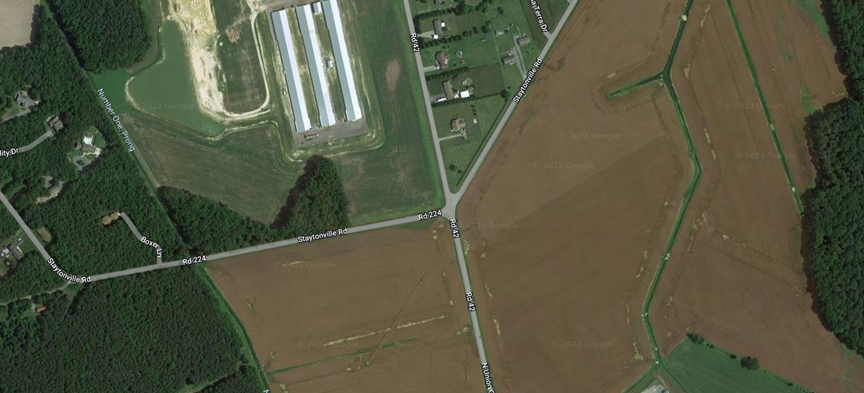

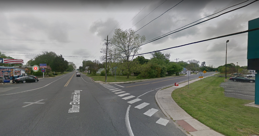


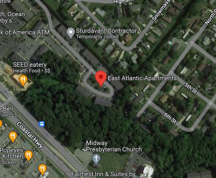


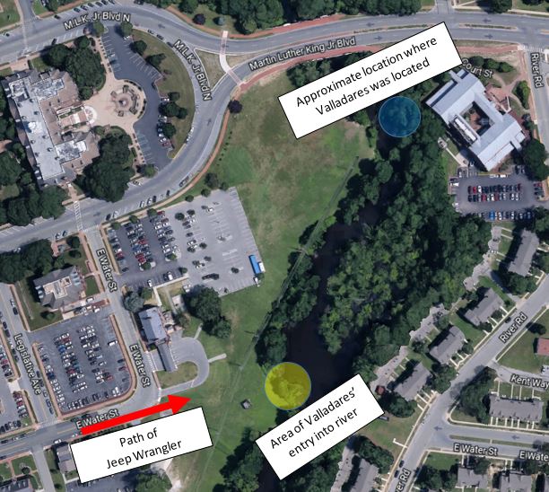


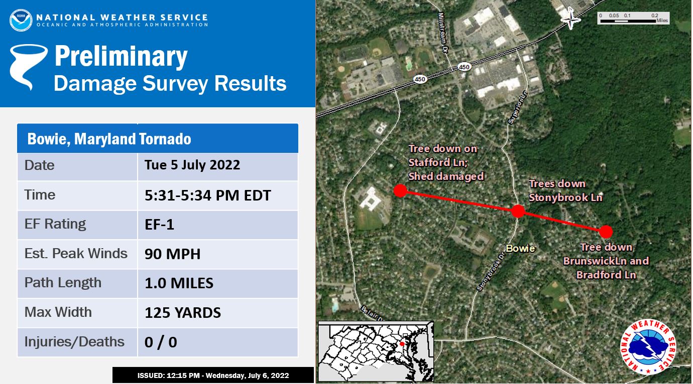


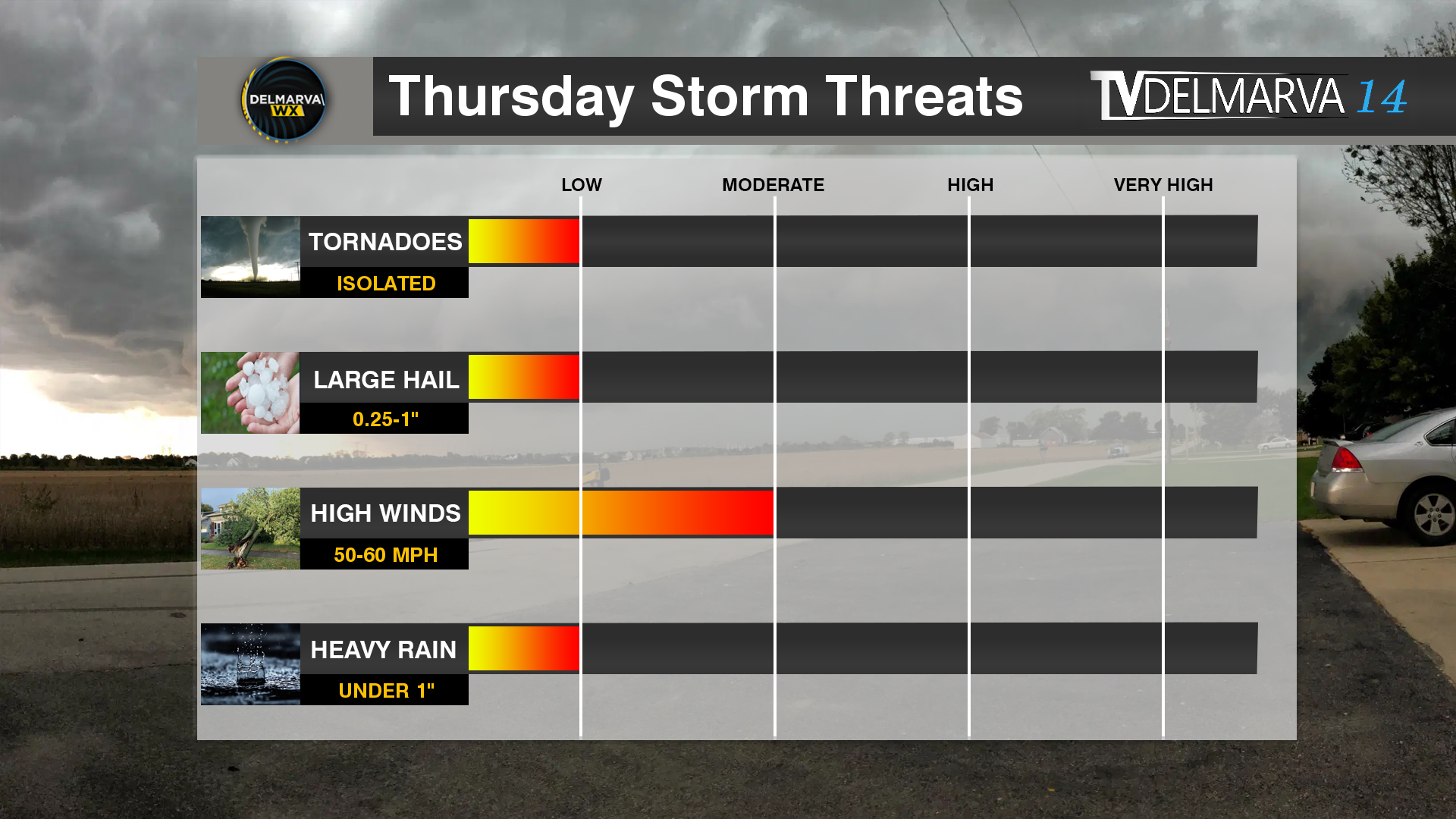


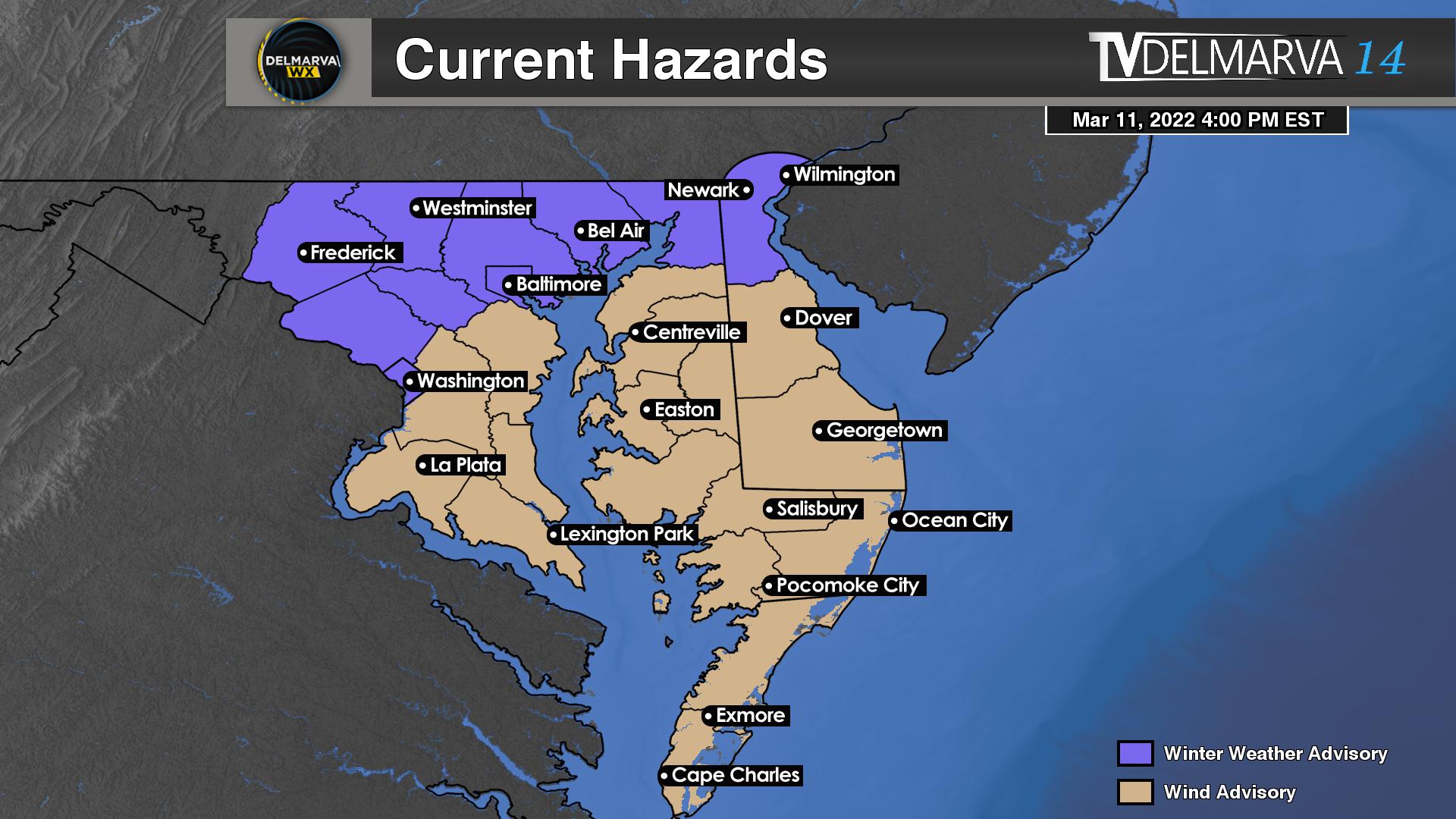

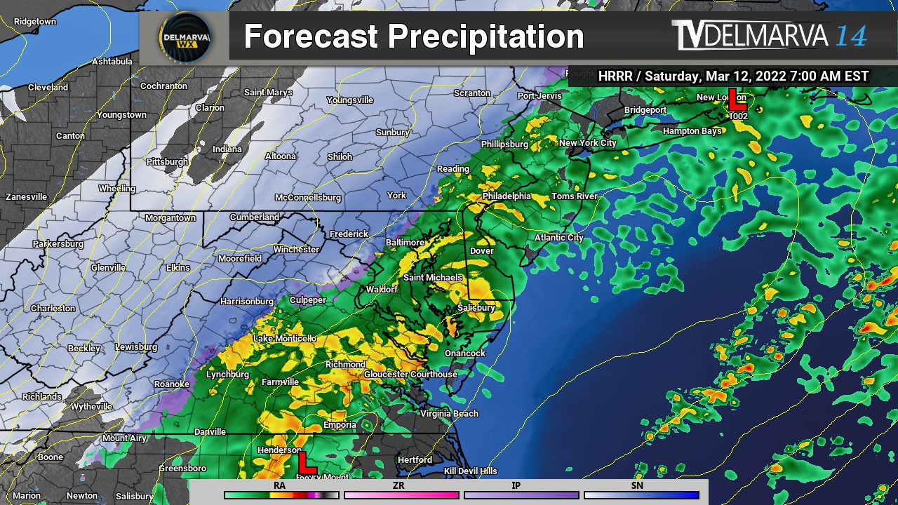


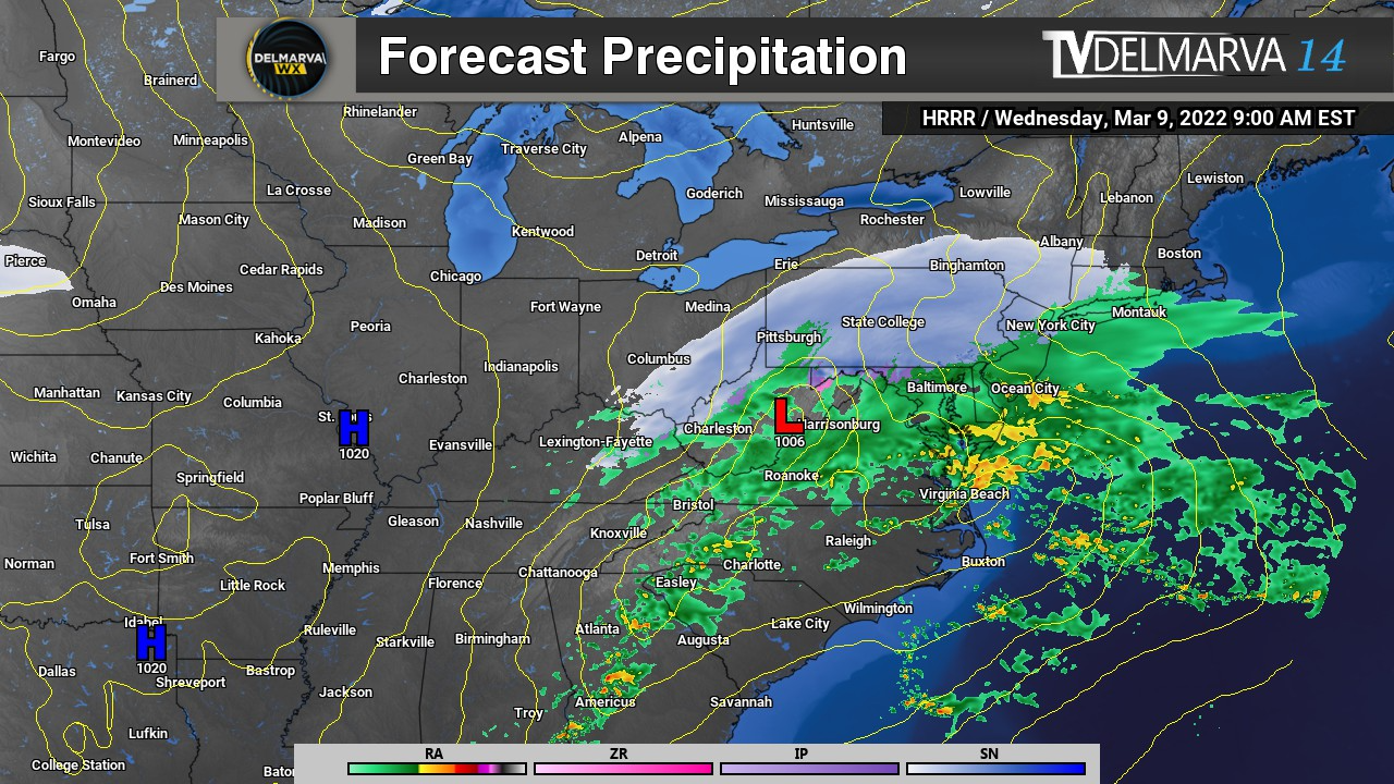


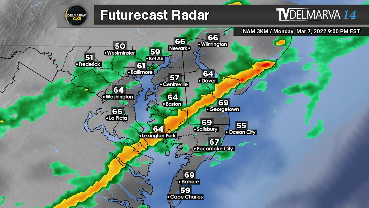


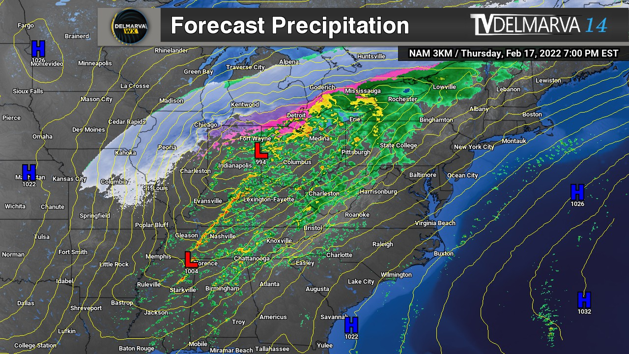


