
ALBUQUERQUE, N.M. — The legendary highway that inspired countless songs and road trip dreams reaches a major milestone this year as Route 66 celebrates its centennial anniversary.
Known as the Mother Road after author John Steinbeck gave it that nickname, this iconic stretch of asphalt has transformed from a lifeline for Depression-era farmers escaping dust bowl devastation into America’s most famous road trip destination.
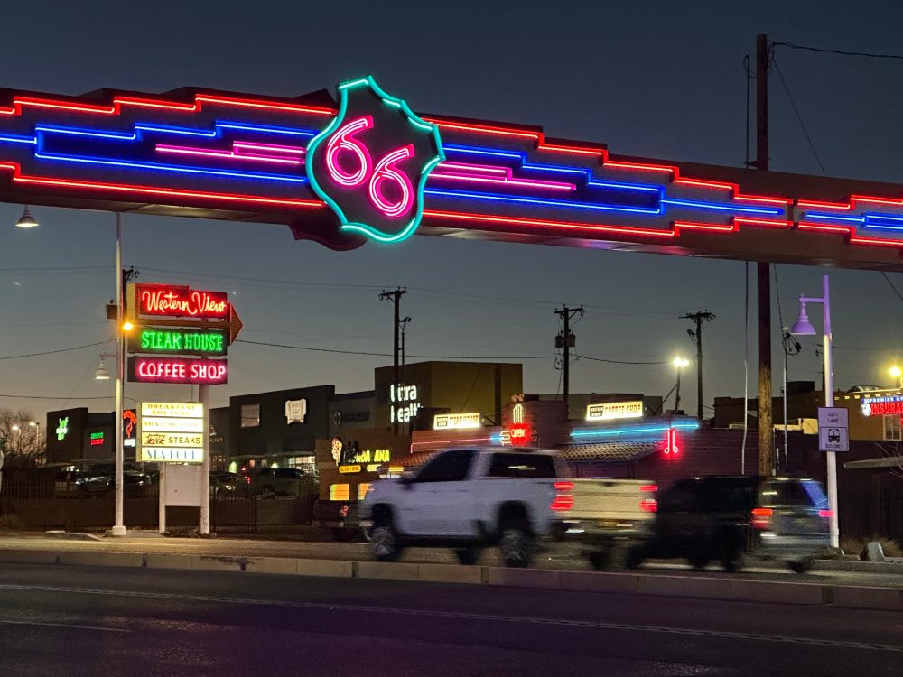
While faster interstate highways now connect Chicago and Los Angeles more efficiently, Route 66’s glowing neon signs and weathered billboards continue drawing adventurers to classic motor courts, old-fashioned diners, and bizarre roadside stops.
Every destination along the route sparks curiosity about the generations of travelers and communities that have kept this highway alive through the decades.
Chicago’s position as a major economic hub with Great Lakes shipping access and cross-country rail connections made it the logical starting point for Oklahoma entrepreneur Cyrus Avery’s vision in the 1920s. Avery, later called the Father of Route 66, recognized that automobiles would soon revolutionize American transportation.
Serving on the federal commission tasked with designing the national highway network, Avery deliberately selected the number 66, understanding that those matching digits would stick in drivers’ memories and prove perfect for promotion.
Many Route 66 enthusiasts find themselves motivated more by culinary discoveries than scenic vistas, with options ranging from fresh-baked pies and creamy milkshakes to juicy burgers and various deep-fried specialties.
Springfield’s Cozy Dog Drive In represents one of many establishments that emerged alongside Route 66, where corn-battered hot dogs on sticks remain popular decades later. Current third-generation proprietor Josh Waldmire keeps his family’s preparation method confidential.
Josh’s grandfather Ed recognized the potential for this portable creation as ideal highway fare and invented a vertical frying technique for the corn dogs.
The winding highway naturally features unexpected curves, so it makes sense that a road celebrated for unusual attractions would span America’s greatest river via one of engineering’s more distinctive spans.
Approaching St. Louis, the mile-long Chain of Rocks Bridge stretches more than 60 feet above the Mississippi River’s waters.
Transportation officials eventually constructed a more direct, faster replacement, and poor demolition economics saved the original structure. The historic bridge now serves exclusively pedestrians and bicycle riders.
Missouri’s St. Robert Route 66 Neon Park displays rescued illuminated signs that once guided motorists to various highway businesses and destinations. These often handmade creations functioned not just as advertisements for lodging, restaurants and fuel stops, but as genuine folk art representing local character.
Kansas contains only a brief Route 66 segment, but delivers memorable experiences at Galena’s Kan-O-Tex Service Station. This perfect example of roadside architecture inspired elements of Pixar’s 2006 animated feature “Cars.”
Director John Lasseter and his team traveled the highway extensively, researching historical details and seeking inspiration for their project. In Galena, they discovered the vintage tow truck that became the model for character Tow Mater. The storyline reflected reality, as many thriving communities — like fictional Radiator Springs — nearly disappeared after interstate bypasses.
Kansas also preserves the Brush Creek Bridge, known locally as the Rainbow Bridge. This National Register of Historic Places structure represents one of the few surviving concrete arch bridges designed by engineer James Barney Marsh.
Serious hazards awaited certain travelers, especially Black motorists navigating hostile, segregated regions during Jim Crow segregation. The Green Book — initially published in 1936 by Victor Hugo Green — identified lodging, dining and fuel establishments willing to serve African American customers.
The Threatt Filling Station near Luther wasn’t featured in The Green Book, but provided sanctuary for fuel, barbecue and baseball. This National Register of Historic Places site was the only documented Black-owned gas station operating along Route 66.
Abandoned structures and fading signage dot Route 66, but Sapulpa’s restored Tee Pee Drive-In Theater near Tulsa demonstrates the highway’s enduring appeal. This 1950s throwback recalls the era when automobile culture spawned thousands of outdoor movie venues nationwide.
Constructed in 1949, the drive-in premiered in spring 1950 with John Wayne’s “Tycoon.” It featured unusual paved walkways for its time. The facility survived tornado damage, concession stand fires and break-ins before closing for over two decades, finally reopening in 2023.
Amarillo’s Cadillac Ranch demands attention during any Route 66 journey. For generations, visitors have spray-painted the ten buried vintage Cadillacs while contemplating time’s passage, much like Bruce Springsteen did in his 1980 song sharing the site’s name.
This isn’t an actual ranch but a public art installation created in 1974 by the Ant Farm collective. Initially, the half-buried cars angled at 60 degrees served as shooting targets, with people carving initials into the metal before spray painting became the tradition.
Adrian marks the journey’s halfway point, where a white line designates Route 66’s center near the Midway Cafe, famous for “ugly pies” that taste far better than their name suggests.
Still hungry travelers can return to Amarillo for The Big Texan’s 72-ounce steak challenge with full accompaniments — finish everything within an hour and the meal costs nothing.
Over half of Route 66 crosses sovereign tribal territories, often following paths used by Native Americans long before European settlement. Like 19th-century railroads, the highway created new commercial opportunities while unfortunately promoting cultural stereotypes.
Faded references to tipis and feathered headdresses still appear at some highway stops. These symbols were easily borrowed for marketing purposes by roadside vendors but didn’t represent the distinct Native American cultures actually present in these areas.
Today, tribal communities share their authentic stories and showcase their own creations, including pottery, fruit pies and poetry.
Albuquerque features Route 66’s longest continuous urban section. These 18 miles wind through multiple neighborhoods and commercial areas, from historic Old Town to the Nob Hill district.
Several vintage motor lodges and neon signs along present-day Central Avenue have undergone restoration. Other signs receive creative makeovers using hubcaps, elaborate lowrider-style paint schemes and New Mexico’s distinctive yellow and red license plates, celebrating the city’s ongoing automotive culture.
Musician Jackson Browne experienced car trouble in Winslow during an early 1970s road trip, inspiring lyrics for the Eagles’ hit “Take it Easy.” However, this represents just one essential track for any Route 66 playlist.
Bobby Troup composed a timeless American driving anthem in the 1940s with “(Get Your Kicks on) Route 66.” Artists including Nat King Cole, Chuck Berry, The Rolling Stones and Depeche Mode have recorded their own versions across the decades.
While standing on Winslow’s famous corner, don’t be surprised when someone approaches with a guitar to perform favorites from their personal road trip collection.
Before departing Arizona, the former gold mining settlement of Oatman provides Wild West atmosphere with daily gunfight reenactments and friendly burros. Oatman was accessible via an original Route 66 alignment through the dangerous Black Mountains passage, but later improvements in the 1950s created a bypass.
Roy’s Motel & Café in Amboy once served as a desert oasis and remains a quintessential Route 66 landmark. The towering neon sign ranks among the highway’s most photographed locations. Inside, international currency left by global visitors covers one wall. Across the street, a clothing post decorated with shoes, shirts and miscellaneous items rises from the desert floor.
This Mojave Desert highway section provides unique solitude. The pavement becomes rough in places while the landscape dominates, showcasing Joshua trees, vast open spaces and evidence of ancient volcanic activity.
Much of this area remains undeveloped, appearing largely unchanged since Route 66’s 1926 designation.
After navigating frequently congested Los Angeles traffic, the famous Santa Monica Pier signals journey’s end with continuous celebration featuring steady streams of spectators and entertainers. While many Route 66 segments have deteriorated, the spectacular Pacific Ocean views remind travelers of the opportunities this highway has provided over the past century.