Tag: weather

  • Extreme Heat Risk Expands Across Eastern U.S.; Mid-Atlantic Faces Highest Threat Entering July

    Extreme Heat Risk Expands Across Eastern U.S.; Mid-Atlantic Faces Highest Threat Entering July

    June 22, 2026

    A potentially dangerous and prolonged heat wave could impact millions of Americans heading into the start of July, according to the latest outlook from the National Weather Service’s Climate Prediction Center (CPC).

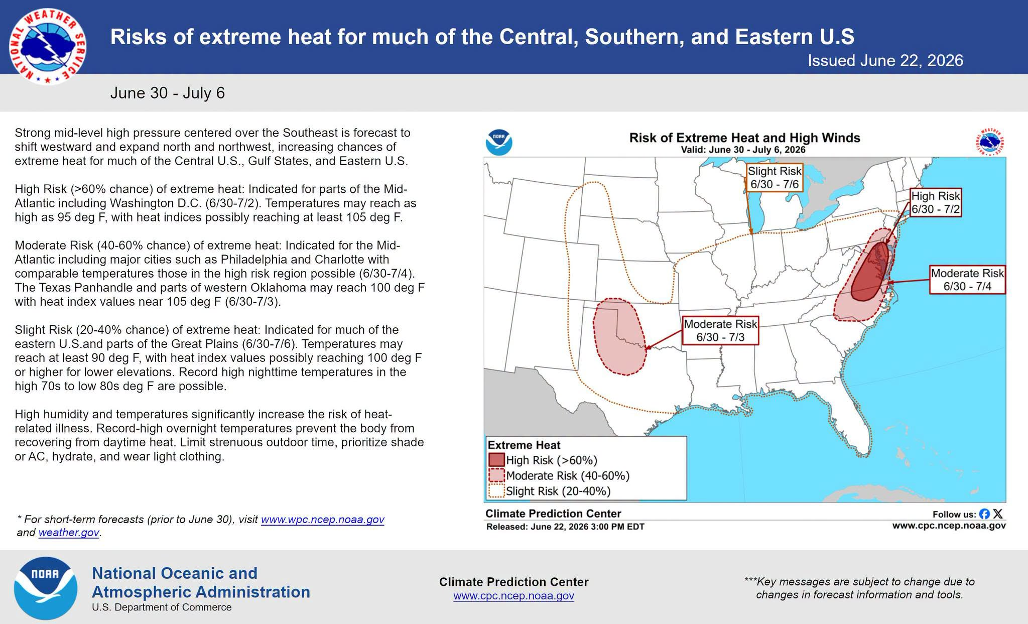
    A strong area of high pressure centered over the southeastern United States is expected to strengthen and expand northward and westward between June 30 and July 6, increasing the likelihood of extreme heat across much of the Central, Southern, and Eastern United States.

    The greatest concern exists across portions of the Mid-Atlantic, where a High Risk (greater than 60% chance) of extreme heat has been highlighted from June 30 through July 2. Areas including the Washington, D.C. metropolitan region could experience afternoon temperatures climbing into the mid-90s, while heat index values may soar above 105 degrees.

    A broader Moderate Risk (40-60% chance) area extends across much of the Mid-Atlantic and parts of the southern Plains. Major cities such as Philadelphia and Charlotte could experience several consecutive days of oppressive heat and humidity. Across western Oklahoma and the Texas Panhandle, temperatures may approach 100 degrees, with heat index values nearing 105 degrees.

    Meanwhile, a Slight Risk (20-40% chance) for extreme heat covers a large portion of the eastern United States and parts of the Great Plains through July 6. Many locations within this area could see temperatures exceed 90 degrees, with heat index values reaching 100 degrees or higher.

    In addition to the daytime heat, forecasters are increasingly concerned about warm overnight temperatures. Nighttime lows may remain in the upper 70s to lower 80s, limiting the body’s ability to recover from the daytime heat and increasing the risk of heat-related illnesses.

    The CPC notes that high humidity levels combined with persistent heat can create dangerous conditions, particularly for vulnerable populations, outdoor workers, and those without reliable air conditioning.

    Residents are encouraged to stay hydrated, limit strenuous outdoor activities during the hottest parts of the day, wear lightweight clothing, and seek air-conditioned environments whenever possible.

    While forecast details may continue to evolve over the coming days, confidence is growing that a significant heat event will affect much of the eastern half of the nation as July begins. Communities across the Mid-Atlantic should closely monitor future forecasts and prepare for the possibility of several days of dangerous heat and humidity.

  • Strong Thunderstorms Possible Across the Mid Atlantic This Afternoon

    Strong Thunderstorms Possible Across the Mid Atlantic This Afternoon

    A more active weather pattern is expected to unfold across the Mid Atlantic today as a disturbance moving out of the Great Lakes pushes toward the Ohio Valley and East Coast. Forecasters are monitoring the potential for scattered strong to severe thunderstorms this afternoon and evening, especially across portions of Maryland, Delaware, Virginia, and southern Pennsylvania.

    An upper level trough currently swinging southeast through the Great Lakes will help provide the energy needed for thunderstorm development later today. Early morning satellite and water vapor imagery already showed a lead disturbance tracking across southern Ohio into the central Appalachians, helping to spark areas of showers and thunderstorms ahead of the main system.

    At the surface, a frontal boundary draped across the region has been reshaped by ongoing morning rainfall and thunderstorms. As this boundary gradually slides southeast through the day, warm and humid air ahead of it will continue building instability across the Mid Atlantic. Dewpoints climbing into the upper 60s and lower 70s will create a very moisture rich atmosphere capable of supporting stronger storms by this afternoon.

    Clusters of thunderstorms to develop and move east southeastward later today. The primary threat with the strongest storms will be damaging wind gusts ranging from 50 to 65 mph, capable of bringing down tree limbs and causing isolated power outages. Some of the more intense storm cores may also produce small to marginally severe hail.

    While widespread severe weather is not expected, scattered strong storms could become locally intense during the peak heating hours this afternoon into early evening. Residents across the region should stay alert for rapidly changing weather conditions and be prepared for possible severe thunderstorm warnings later today.

    In addition to the wind threat, locally heavy rainfall may also accompany stronger storms given the humid environment already in place across the region.

  • Unsettled Pattern Brings Multiple Rounds of Rain to Delmarva This Week

    Unsettled Pattern Brings Multiple Rounds of Rain to Delmarva This Week

    After a prolonged stretch of cold and limited rainfall, a much more unsettled weather pattern is taking shape across the Delmarva Peninsula this week. Several low pressure systems are expected to move through the Mid-Atlantic, bringing multiple opportunities for measurable rain through the weekend.

    First Round: Wednesday into Wednesday Night

    The first system arrives Wednesday afternoon into Wednesday night as a warm front lifts northward ahead of low pressure tracking through the Midwest.

    For Delmarva, this system is expected to bring mainly light rain, with recent model trends pointing toward an all-rain event. Rainfall amounts look modest overall, with:

    • Low probability of totals exceeding 1 inch
    • Most locations likely seeing light to moderate rainfall
    • Rain chances highest Wednesday afternoon and evening

    While rainfall amounts do not appear heavy, this system could deliver the first measurable rainfall in several weeks for parts of the region, as recent precipitation events have largely fallen as snow due to persistent cold temperatures.

    Thursday: Spotty Showers Possible

    Delmarva remains in the warmer sector of the system Thursday into Thursday night. That means temperatures stay milder, and while widespread rain is not expected, isolated showers may pass through at times.

    Second System: Friday into Saturday

    Another low pressure system moves toward the region late Friday into Saturday. Much like the midweek system, this one also appears to favor primarily rain across Delmarva.

    Current projections suggest:

    • Rain likely late Friday into early Saturday
    • Lower probabilities of heavy rainfall
    • No significant winter weather concerns for the Peninsula

    At this time, forecast guidance does not indicate any moderate or major impacts from this system.

    Watching the Weekend

    Looking ahead to late weekend, there are signals of yet another potential system. However, forecast models vary significantly on its strength and track. It is too early to determine specific impacts or precipitation types, but it is something forecasters will continue monitoring.


    Overall Impact for Delmarva

    For the Delmarva Peninsula, this upcoming pattern looks to bring beneficial rainfall rather than disruptive weather. After weeks of colder conditions and limited liquid precipitation, this stretch of rain could help recharge soils and provide needed moisture without significant flooding concerns.

  • Will It Storm Or Will It Be Another Dud? The Talk About Sun-Mon Storm Signal

    Will It Storm Or Will It Be Another Dud? The Talk About Sun-Mon Storm Signal

    We are gearing up to be in a fairly hostile pattern with many pieces of energy to play with here over the next 2 weeks as a large long wave trough sits over the eastern US. The biggest issue right now is do they interact with each other or will they remain strung out wasting the potential for snow lovers out there.

    While the overall risk of impactful wintry weather remains low heading into early next week, colder temperatures mean even small changes in the forecast could introduce a chance for snow.

    A brief warm up to near seasonal levels is expected Saturday ahead of a passing cold front. Behind it, a colder pattern looks likely to settle back in and persist through at least the middle of next week, with temperatures running below normal. During this time, several weak disturbances are forecast to move through the region. While none of these systems appear particularly strong on their own, there is a possibility they could interact in a way that brings a wintry weather threat late Sunday into Monday.

    At this time, the most likely outcome would be flurries or light snow, with limited or no accumulation. However, if the shortwave has more of a interaction with the Jetstream, that can bring larger impacts. Forecast confidence remains low, with precipitation chances generally in the 20 to 30 percent range.

    Given the cold air in place, this period will need to be monitored closely for any changes that could increase the wintry weather threat. For now, the risk of a significant winter storm from Sunday into early next week remains low, but not zero.

  • Winter Uncertainty Towards The Late Week; Social Media Hype Is Crazy Right Now

    Winter Uncertainty Towards The Late Week; Social Media Hype Is Crazy Right Now

    Forecast guidance continues to signal the potential for a disruptive winter weather pattern later this week, mainly from Wednesday through Friday, as an upper level low strengthens over the Lower Great Lakes and moves toward the Northeast. This system is expected to bring an increase in wintry precipitation across parts of the Lower Great Lakes, the central Appalachians, and portions of the interior Northeast, with colder air also setting the stage for lake effect snow in typical snowbelt regions.

    However, confidence in the overall setup remains low. Key details such as the exact placement and strength of the upper level low are still uncertain, which will ultimately determine where the heaviest precipitation develops. There is also considerable question surrounding coastal low development, including whether it forms too late, remains weak, or tracks well offshore. Recent trends as of today favor a later developing system that stays farther out to sea, which would significantly limit impacts for much of the I-95 corridor.

    The primary question for Delmarva centers on whether a coastal low is able to develop in time and close enough to influence the region. Current guidance shows large spread in both timing and track, with recent trends favoring a system that forms too late and remains well offshore. If this trend holds, meaningful winter weather impacts across Delaware, eastern Maryland, and Virginia’s Eastern Shore would be limited or possibly avoided altogether.

    Because of these uncertainties, forecast impacts to travel and infrastructure remain unclear at this time. While some wintry weather is possible inland, especially across higher elevations and areas closer to the Great Lakes, any coastal impacts would depend on how quickly and how close a coastal low can organize. Forecast confidence should improve over the next few days as the system comes into better range of higher resolution models.

  • January Thaw Ongoing For Now, Winter Making A Return Towards Next Week

    January Thaw Ongoing For Now, Winter Making A Return Towards Next Week

    With days as of this past week constantly being int he 50’s and even 60’s, many wonder where did winter go? Normally in the winter months across the lower 48 go through a longer duration warming trend as a recharge of the overall pattern and sign are pointing at a return to more winter weather moving back across the eastern half of the US.

    Weather models are all onboard for a bigger shift in the overall weather pattern across the Northern Hemisphere Mainly what’s going on across the Pacific Ocean which is the biggest driver to the Lower 48 weather pattern for supplying the cold air and the active storm track. One thing that is peaking my interests is a significant drop in the Eastern Pacific Oscillation during the time period of the 14th-20th.

    A very large negative Eastern Pacific Oscillation, or EPO, is a significant large scale weather pattern that can strongly influence temperature and storm tracks across the United States, especially during the fall and winter months.

    When the EPO is strongly negative, a powerful ridge of high pressure builds over the eastern Pacific, often near Alaska and the Gulf of Alaska. This ridge acts as a blocking feature, forcing the jet stream to buckle sharply northward into Alaska and then dive southward downstream into western and central North America. As a result, Arctic air is displaced south out of Canada and into the United States.

    For the western United States, a negative EPO often brings colder than normal temperatures, particularly to the Pacific Northwest and northern Rockies. The ridge offshore can suppress precipitation along parts of the West Coast, leading to drier conditions in California, while the colder air aloft supports snow in the higher elevations of the Northwest and Intermountain West when storms are able to undercut the ridge.

    Across the central and eastern United States, the downstream response to a negative EPO is often a broad trough, which allows cold air to spill southward. This can lead to below normal temperatures across the Plains, Midwest, and East Coast. When moisture is available, this pattern can be favorable for winter storms, as cold air at the surface can interact with southern stream systems or coastal lows.

    The strength of the negative EPO matters. A weak negative phase may only produce brief or modest cold shots, while a strongly negative EPO can support prolonged cold outbreaks, sometimes reaching deep into the southern United States. This setup can also increase the likelihood of sharp temperature swings if the blocking ridge eventually breaks down.

    Weather across the Eastern US might get very interesting going forward into the mid-month.

  • Periods of Rain Expected Across Delmarva Through the Weekend

    Periods of Rain Expected Across Delmarva Through the Weekend

    Residents across the Delmarva Peninsula should prepare for several rounds of rain as a series of weather systems move through the region from late Friday into early Sunday. While no significant flooding or severe weather is expected, the stretch will bring generally wet and mild conditions.

    The first system arrives late Friday as a weakening cold front moves into the Mid-Atlantic. This front is tied to an area of low pressure lifting north from the Great Lakes toward Quebec. Rain is expected to develop Friday afternoon and continue into Friday night. As the front weakens and gradually dissipates over the region, temperatures are not expected to drop noticeably, with little to no cold air pushing in behind it.

    A second, more impactful system follows on Saturday. A deepening upper-level trough moving south from Canada into the Great Lakes will help spawn a new surface low over the lower Mississippi River Valley. This low will track northeast, pushing a warm front northward across Delmarva on Saturday. As the warm front lifts through the region, rain coverage will increase and milder air will overspread the peninsula.

    Temperatures on Saturday may behave unusually, with some locations seeing their highest readings later in the day or even during the evening hours as warmer air moves in. Overnight temperatures may hold steady or even rise slightly in some areas. Overall, Saturday is expected to be a warm and wet day, with temperatures ranging from the upper 40s to the low 60s.

    Heavier rain is expected to move in later Saturday as an initial cold front crosses the region. While a brief rumble of thunder cannot be ruled out due to some elevated instability in the atmosphere, no severe weather is anticipated. Showers may linger Saturday night until a secondary cold front moves through on Sunday morning. Behind that front, winds will increase, but the chance of wind gusts reaching advisory levels remains low.

    There is higher confidence that Delmarva will see periods of rain from Friday afternoon through Sunday morning, though exact rainfall totals remain uncertain. Most guidance suggests at least a half inch of rain, with some models indicating localized totals between 1.5 and 2 inches. The probability of receiving one inch or more of rain is around 40 to 60 percent, while the chance of exceeding two inches is low.

    Rainfall is expected to fall over a 36 to 48 hour period with breaks between systems, reducing the risk of flooding. With mild temperatures in place leading into the weekend, any remaining ice in streams or rivers should have already melted, allowing water to drain efficiently. Confidence in rainfall totals and timing is expected to improve as the weekend approaches.

  • High Winds And Cooler Temps Follow Behind Cold Front This Weekend

    High Winds And Cooler Temps Follow Behind Cold Front This Weekend

    A strong cold front moving through the Northeast is expected to bring a period of gusty winds through Sunday night, with the highest wind gusts occurring in the wake of the front. Widespread gusts of 40 to 55 mph are likely across much of the Mid-Atlantic and interior Northeast, including Pennsylvania, New Jersey, New York, and New England. Stronger gusts in the 55 to 65 mph range are possible across parts of upstate New York and areas downwind of the Great Lakes, where the pressure gradient will be strongest. Along the coast, especially across New Jersey, Long Island, and southern New England, gusts may exceed 50 mph, increasing the risk for downed trees, power outages, and travel disruptions.

    Here is a break down per state in the region…

    Delaware:
    Strong winds are expected behind the cold front, with peak gusts generally ranging from 45 to 55 mph statewide. The highest gusts are most likely along the coast and across the Delmarva Peninsula, where marine influence and a tighter pressure gradient could push isolated gusts slightly higher. These winds may lead to scattered power outages and difficult travel, especially on bridges and causeways.

    Maryland:
    Widespread gusts of 45 to 55 mph are forecast across much of Maryland, including the I-95 corridor from Baltimore to Washington. Western Maryland could see locally stronger gusts approaching 55 to 60 mph, particularly in higher elevations and along exposed ridgelines. The combination of saturated soils and strong winds may increase the risk for downed trees and power lines.

    Virginia:
    Much of northern and central Virginia can expect wind gusts between 40 and 50 mph, with higher gusts of 50 to 55 mph possible across eastern Virginia and along the Chesapeake Bay. Coastal and tidal areas may experience the strongest winds as colder air surges in behind the front. Impacts may include isolated power outages, difficult travel for high-profile vehicles, and minor coastal concerns.

  • Winter Takes a Break Across The Country But For How Long?

    Winter Takes a Break Across The Country But For How Long?

    The month of December brought well below average temperatures across much of the Mid-Atlantic region. Averaging as much as 4 to 6 degrees below normal. Putting impacts on energy costs already this early into the season but we are looking to see some relief on those heating bills over the next week. starting Tuesday, we flip the switch from being the freezer to being able to thaw out in a big way.

    Throughout the rest of this week, we are about to go from January weather to what i would say be ;ate October weather as we start cranking up to the 50s. Eventually towards the weekend we are even crossing the 60s threshold. Which is going to feel quite nice after being stuck every day in the 30s. But the real question lies, how long will this warm up will last?

    It appears this will be a week long warm up with the warmest time frame appearing closer to the weekend with highs approaching the mid 60s. But also bring the onset of rain chances as a storm system will be lifting up towards the Great Lakes area. But towards the mid-month, signs are pointing to a return of the west coast ridge allowing for troughs to extend east towards the Mid-Atlantic to bring back more seasonable temperatures. Cold air intrusion would be possible after the 15th when this occurs so that’s when any snow chances would return as of now.

    Enjoy the warmth and thaw while it last as we still have a whole lot of winter to get through!

  • Widespread Warmth Expected Across Eastern U.S. in Mid-January Outlook

    Widespread Warmth Expected Across Eastern U.S. in Mid-January Outlook

    A strong signal for above-normal temperatures is shaping up across much of the eastern United States as we head into the January 8–12, 2026 timeframe, according to the latest 6–10 day temperature outlook issued by NOAA on January 2.

    The outlook shows a broad and confident area of above-average temperatures extending from the Mississippi Valley eastward to the Atlantic Coast. This includes the Midwest, Ohio Valley, Southeast, and much of the Mid-Atlantic and Northeast. In these areas, probabilities favoring above-normal temperatures range from 60% to as high as 90%, indicating a strong likelihood that temperatures will trend warmer than what is typical for early January.

    For the Mid-Atlantic region, including Delmarva, Maryland, and Pennsylvania, the signal is particularly robust. Persistent ridging in the upper atmosphere is expected to keep Arctic air bottled up well to the north, allowing milder air to dominate. This pattern would favor daytime highs running several degrees above normal, with fewer opportunities for sustained cold or wintry weather during this period.

    In contrast, below-normal temperatures are favored across portions of the western United States, especially parts of California, the Great Basin, and the Southwest. These regions show a 33–60% probability of cooler-than-average conditions, suggesting a more active Pacific pattern delivering cooler air and potentially unsettled weather.

    Areas of the northern Rockies and portions of the interior West are expected to remain near seasonal averages, lying along the transition zone between the cooler West and warmer East.

    Alaska shows a split pattern, with below-normal temperatures favored across much of the mainland, while parts of the southern coast lean above normal. Hawaii is expected to see above-average temperatures statewide.

    Overall, the pattern supports a continuation of a relatively mild January for large portions of the eastern U.S., potentially limiting snow and ice opportunities while increasing the risk of rapid snowmelt in areas that currently have snowpack.

  • A Lot Of Talk About Wintry Weather Jan 6-8th…

    A Lot Of Talk About Wintry Weather Jan 6-8th…

    There has been a ton of speculation over social media about “Major Winter Storm Signal Jan 6-8th” and different variations for click bait and cash grabs for views. For many who know me over the last 15 years, I tell it like it is. And many of these social media pages need to keep their anticipation in check. I will go through the good and the bad for snow lovers with all this hype being shared around the internet about this timeframe.

    So the big take aways is what’s going on with the North America weather pattern changing a bit from this past week to a more colder one. But the biggest issues that people see on these maps is anytime they see a trough in the east immediately go “MAJOR WINTER SIGNAL, MAJOR STORM AHEAD” but there is so much more that goes into play. Yes we are looking at a trough across the eastern US, that’s only the first step. There is some blocking showing up in the arctic with the ECMWF but much weaker with the GFS. Blocking near Greenland helps slow down the overall weather pattern or for all the technical readers out there a -NAO block. So we have two pieces of the puzzle but there is something way more important in my opinion and its what’s going on the west coast.

    And that’s where my excitement starts going down the tubes as a snow lover. We need ridging in the west coast to get the trifecta ingredients. And this is where things start falling short for my liking. Not only that we have polar opposites in guidance between the two major long range models for this range and the placement is not ideal. Ridging along the west coast not only brings the cold air supply with cross polar flow and helps amplify the trough to its east. With this sitting over the Rockies, not the most ideal to get something off our coastlines. I prefer to have it back right at the coast instead but we also have a trough not too far away to the west side. ECMWF is your friend and the GFS is you enemy with the PNA across the west coast. Hard to say which will be correct until one switches as we get closer in time. This is why I have been thinking it’s so dumb to be stating about a storm is happening in this time frame because of the PNA in itself.

    One thing is for sure, we are looking to see some colder weather over in our neck of the woods going into the New Year. As temp anomalies over the next 1-2 week showing increasing confidence of “Below Average Temperatures” in the Mid-Atlantic & New England. Moral of the story, hold your excitement for now and be wary of pages that post this kind of hype and 384 hour snowfall maps claiming this is what’s ahead. It’s just not good and its a spreading terrible false information. It’s a cash grab for getting views and traffic for all the wrong reason. Trust your reliable sources friends.

  • SNEAKY ICING EVENT ON BOXING DAY DEC 26-27TH?

    SNEAKY ICING EVENT ON BOXING DAY DEC 26-27TH?

    December 26-27th event has been a model guidance nightmare these past few days so that’s why i haven’t really talked much about it. Because at one moment its a 63 degree day with rain and then next minute its a day with accumulating snow and ice. This is very typical back and forth nonsense that happens in the 84-120hr timeframe so i don’t put a whole lot of weight to it. But we are starting to get into the sub 84 timeframe where they begin to get their act together. So here is the setup.

    We will already have a push of arctic air in place out ahead of a weak disturbance with a warm front nosing into the cold air. This is a classic representation of what we call a “Overrunning Event”

    An overrunning event in winter meteorology occurs when warm, moist air is lifted up and over a shallow layer of cold air at the surface. This setup is common ahead of winter storms and often develops north of a warm front. Because cold air is denser, it remains trapped near the ground while warmer air flows over it along sloping isentropic surfaces.

    As the rising warm air cools, clouds and precipitation develop well in advance of the main storm system. In winter, this frequently leads to widespread, long-duration precipitation, often falling as snow, sleet, or freezing rain, depending on the temperature profile of the atmosphere. Overrunning events are typically associated with stratiform precipitation, lower visibility, and steady rather than convective rainfall or snowfall.

    These events can produce significant winter weather impacts, including heavy snow accumulations, ice accretion, and hazardous travel conditions, especially when cold air is reinforced at the surface by high pressure to the north. Overrunning precipitation often marks the initial phase of a winter storm before stronger dynamics and surface low pressure move in.

    With the latest mid day mid range guidance rolling in they are starting to come into light of a icing scenario beginning to unfold across areas of central and northern Delmarva, northern Maryland, and portions of South Jersey. A lot of factors remain in place like will the cold air remain more locked in and keep the warm nose at bay, will the warm nose make it a widespread icing event, or will the warm nose overwhelm the environment and keep it more of a rain threat in the region. Those are the details we need to iron out going later into the week.

  • Nationwide Warm-Up Expected Through Christmas

    Nationwide Warm-Up Expected Through Christmas

    New outlooks from the Climate Prediction Center indicate a pronounced and persistent warm pattern developing across much of the United States over the next one to two weeks, including through the Christmas holiday. Both the 6–10 day and 8–14 day temperature outlooks show above-normal temperatures dominating the central and eastern portions of the country, signaling a sustained break from typical late-December cold.

    A large area of strongly above-average temperatures is forecast to build across the Plains, Midwest, and South, with the warmest anomalies centered from the central Plains into the Lower Mississippi Valley. This warm ridge is expected to expand eastward as we head closer to Christmas.

    Mid-Atlantic Focus

    For the Mid-Atlantic region, including Delmarva, confidence is increasing in a milder-than-normal stretch of weather heading into and through the holiday period. Temperatures are favored to run above seasonal averages, with daytime highs frequently reaching the 50s and potentially near 60 degrees at times, depending on cloud cover and frontal timing. Overnight lows are also expected to remain milder, reducing the risk of prolonged cold snaps.

    While brief cool-downs remain possible as weak fronts pass through, no sustained Arctic air intrusions are currently indicated in the extended outlook. This pattern significantly lowers the chances for a widespread white Christmas across the Mid-Atlantic, with precipitation events more likely falling as rain rather than snow.

    Looking Ahead

    Overall, the pattern supports a quiet and relatively mild end to December for much of the eastern U.S. If this outlook holds, the Mid-Atlantic can expect a holiday season that feels more like late fall than mid-winter, with continued monitoring needed in case pattern shifts develop closer to Christmas.

  • Heavy Rains, Thunder, And High Winds On The Way Tonight Through Friday

    Heavy Rains, Thunder, And High Winds On The Way Tonight Through Friday

    A strong cold front is expected to move through the region later this evening, bringing periods of moderate to heavy rainfall, with the potential for a few embedded thunderstorms. Ahead of the front, a surge of unseasonably warm air continues to advance up the East Coast, allowing afternoon temperatures to rise into the upper 50s to near 60 degrees.

    ...WIND ADVISORY REMAINS IN EFFECT FROM 1 AM FRIDAY TO 1 AM EST
    SATURDAY...
    
    * WHAT...Southwest winds 20 to 30 mph with gusts up to 45 mph
      expected Thursday night through Friday morning. Winds turn to the
      northwest behind a strong cold front Friday afternoon. There may
      be a lull in the strongest wind gusts around midday Friday before
      the cold front passes through the region. Wind gusts in the wake
      of the front up to 50 MPH are possible.
    
    * WHERE...In Delaware, Delaware Beaches County. In New Jersey,
      Eastern Monmouth, Western Monmouth, Atlantic, Atlantic Coastal
      Cape May, Cape May, Coastal Atlantic, Coastal Ocean, Ocean, and
      Southeastern Burlington Counties.
    
    * WHEN...From 1 AM Friday to 1 AM EST Saturday.
    
    * IMPACTS...Gusty winds will blow around unsecured objects. Tree
      limbs could be blown down and a few power outages may result.
    
    PRECAUTIONARY/PREPAREDNESS ACTIONS...
    
    Winds this strong can make driving difficult, especially for high
    profile vehicles. Use extra caution.

    As the frontal boundary approaches, winds will strengthen significantly, with gusts of 40 to 50 mph possible across portions of New England and the Mid-Atlantic. A Wind Advisory is in effect for several areas. Rainfall totals are currently forecast to range between 0.50 and 1.50 inches, which will be beneficial in helping to alleviate ongoing drought conditions across much of the eastern United States.

    The sharp temperature gradient associated with the frontal passage may provide enough atmospheric instability to support a narrow line of embedded thunderstorms. Within this line, a strong low-level jet could allow isolated stronger wind gusts to mix down to the surface. While widespread severe weather is not anticipated, localized areas may experience brief heavy rainfall and gusty winds.

    Behind the front, gusty conditions will persist through Friday, with winds continuing to gust between 40 and 50 mph at times. Skies will gradually clear as cooler air filters into the region, bringing a return to sunshine and more seasonable temperatures.

  • UPDATED: Accumulating Snowfall Expected Late Tonight; Bitter Arctic Air To Follow

    UPDATED: Accumulating Snowfall Expected Late Tonight; Bitter Arctic Air To Follow

    Another round of accumulating snowfall is on tap for this weekend during the early morning hours Sunday through the late morning hours. Overall snowfall amounts have increased across Central and Northern Delmarva for tonight. A Clipper system approaching from the Mid-west will begin to redevelop a coastal low will bring a band of light to moderate snowfall to the region on Sunday as an arctic frontal boundary moves through bring severely cold temperatures throughout the Eastern US.

    Looks like right now areas across Northern Maryland, Northern Delmarva, and South Jersey will be in the hot seat for seeing the most accumulating snow when the coastal low begins to take over. A widespread swaft of 3-6 inches of snow is likely with areas further south will have lighter precipitation to deal with overall. Making for Sunday morning travel a bit slick with temperatures in the upper 20s to lower 30s and the winds begin to pick up later in the day for some blowing and drifting.

    An Arctic air mass is moving southward, bringing dangerously low temperatures and life-threatening wind chills across a broad swath of the central US, from the Northern Plains towards the Mid-Atlantic

    Temperatures are forecasted to plunge 20 to 30 degrees below normal, with wind chills dropping below -30°F in some areas. This extreme cold poses serious risks to human health, pets, and infrastructure, including the potential for frozen pipes.

    Residents in the affected regions are urged to prepare immediately by taking steps to protect themselves, their animals, and their homes. The agencies emphasize the importance of readiness to mitigate the harsh impacts of this severe weather event.

  • Accumulating Snow On The Way For Sunday; Followed By Arctic Blast

    Accumulating Snow On The Way For Sunday; Followed By Arctic Blast

    Another round of accumulating snowfall is on tap for this weekend during the early morning hours Sunday through the late morning hours. A Clipper system approaching from the Mid-west will begin to redevelop a coastal low will bring a band of light to moderate snowfall to the region on Sunday as a arctic frontal boundary moves through bring severely cold temperatures throughout the Eastern US.

    Looks like right now areas across Northern Maryland, Northern Delmarva, and South Jersey will be in the hot seat for seeing the most accumulating snow when the coastal low begins to take over. A widespread swaft of 2-4 inches of snow seems probable with areas further south will have lighter precipitation to deal with overall. Making for Sunday morning travel a bit slick with temperatures in the upper 20s and the winds begin to pick up later in the day for some blowing and drifting.

    An Arctic air mass is moving southward, bringing dangerously low temperatures and life-threatening wind chills across a broad swath of the central US, from the Northern Plains towards the Mid-Atlantic

    Temperatures are forecasted to plunge 20 to 30 degrees below normal, with wind chills dropping below -30°F in some areas. This extreme cold poses serious risks to human health, pets, and infrastructure, including the potential for frozen pipes.

    Residents in the affected regions are urged to prepare immediately by taking steps to protect themselves, their animals, and their homes. The agencies emphasize the importance of readiness to mitigate the harsh impacts of this severe weather event.

  • Delmarva’s First Measurable Snow Of The Season On Friday

    Delmarva’s First Measurable Snow Of The Season On Friday

    Well folks, it looks like we have our first snowfall of season upon us for Friday. Its not a major event or anything but enough to make things a bit slippery for your Friday morning commute. Only because usually the first snow is the one that gives motorists headaches and no being used to dealing with it on the roadways. Here is the break down.

    A weak flat wave system will be riding along an arctic boundary as precipitation enters the colder airmass. An area of high pressure out ahead providing the fresh arctic airmass will be enough to support a few hours of wet snow across the Mid-Atlantic starting around 2-3am on Friday and become more steady when day breaks. Snow will remain steady through 10am before beginning to taper off and or mixing with rain towards noon across the Maryland Eastern Shore and the VA counties.

    The latest forecast is calling for a spread of a heavy coating to on the high end 2 inches across Southern Maryland and Central Delmarva. This is where the majority of the heavier snow bands will likely end up as temperatures will range from 28-32 during the whole duration. Area further south across Ocean City along the coast will be dealing with some mixing problems at times with the warmer ocean waters nearby. Areas further north across Northern Maryland, Northern Delmarva, and South Jersey will only see a dusting up to a inch with light snow overall based on the latest track.

    As mentioned before, impacts from this winter storm will be very light with only light accumulations expected. Motorists should still use caution on area roadways as they may become icy and slushy at times during the Friday morning commute.

  • Strong Coastal Low Could Bring Major Impacts to Delmarva This Weekend

    Strong Coastal Low Could Bring Major Impacts to Delmarva This Weekend

    A powerful coastal low is forecast to develop off the Carolina coast late this week before strengthening and tracking northward this weekend. The system is expected to bring gusty winds, heavy rain, and coastal flooding to much of the East Coast — including the Delmarva Peninsula.

    The combination of strong onshore winds, high surf, and high astronomical tides could lead to significant coastal flooding across parts of Delaware, Maryland, and Virginia. The most widespread impacts are expected from Friday night through Sunday, with the highest risk during periods of high tide.

    Persistent onshore winds will also generate dangerous rip currents and high surf, likely leading to beach erosion along the Atlantic coastline and the lower Delaware and Chesapeake Bays. Coastal residents should closely monitor updates and follow any advisories issued by local emergency management or the National Weather Service.

    In addition to flooding, the storm could bring wind gusts over 45 mph, especially along coastal areas, which may result in scattered power outages and tree damage. Heavy rainfall could also lead to localized flooding inland, particularly in poor drainage areas.

    The Weather Prediction Center highlights the Delmarva coast as an area of elevated concern for strong wind gusts and coastal flooding potential this weekend.

    Residents are urged to stay alert as the system approaches and to secure outdoor items ahead of the storm.

  • Very Rare “Fujiwhara Effect” Of Tropical Cyclones Potentially Threaten The Eastern Seaboard

    Very Rare “Fujiwhara Effect” Of Tropical Cyclones Potentially Threaten The Eastern Seaboard

    Ladies and gentlemen, we may get to witness an extremely unique weather phenomena coming into early next week. There has been a lot of talk about something called the “Fujiwhara Effect” and this is becoming more of a real scenario which makes forecasting very difficult. We already have Humberto which formed yesterday in areas north and east of the Lesser Antilles which is expected to become a major hurricane towards the weekend. Another tropical wave near Hispaniola is expected to develop into Imelda and will become in close enough proximity to Humberto to do a bit of a waltz we can say.

    First off what is the Fujiwhara Effect? The Fujiwhara effect describes the rotational interaction of two vortices, such as tropical cyclones, where they orbit a common center and can either merge into one larger storm, cause one to be absorbed, or break apart and move away from each other. The effect, named after Japanese meteorologist Sakuhei Fujiwhara, is more common in the Pacific Ocean, where tropical cyclones are more numerous.

    This is exactly what we have going on here with potentially two tropical cyclones is close enough proximity to start doing some very strange movements as they share a similar fulcrum point between each other. Humberto should stay off our coast but Imelda is the one to watch as this becomes a threat towards the Southeast US coastal toward the Mid-Atlantic coasts. To throw a bigger wrench into things, we have a strong surface high moving in across the Great Lakes and New England with a retrograding upper level low in the Midwest. So many steering currents to bring what would be Imelda towards the US Coastlines. And could stall Imelda in place with a tremendous rainfall threat.

    We really need to see if Imelda can form a center of circulation to get a better handle on where it would go and the impacts with the Fujiwhara. This is going to be a fairly impactful and intriguing setup overall. The meteorology behind this is truly astonishing. Regardless, residents along the Eastern Seaboard need to relate alert as we head into the weekend.

  • NOAA Forecasts Above-Normal 2025 Atlantic Hurricane Season

    NOAA Forecasts Above-Normal 2025 Atlantic Hurricane Season

    The National Oceanic and Atmospheric Administration (NOAA) has issued its outlook for the 2025 Atlantic hurricane season, predicting above-normal activity. The season, which runs from June 1 through November 30, is expected to produce 13 to 19 named storms, with six to ten becoming hurricanes, and three to five reaching major hurricane status (Category 3 or higher).

    NOAA attributes the heightened activity to several factors, including warmer-than-average sea surface temperatures in the Atlantic Ocean and Caribbean Sea, and a neutral phase of the El Niño-Southern Oscillation (ENSO), which can influence hurricane development.

    “With the combination of warm ocean temperatures and neutral ENSO conditions, the atmosphere is primed for an active hurricane season,” said NOAA Administrator Rick Spinrad.

    This forecast aligns with projections from other institutions, such as Colorado State University and the UK Met Office, which also anticipate above-average hurricane activity for the 2025 season.

    NOAA emphasizes the importance of preparedness, urging residents in hurricane-prone areas to review their emergency plans and stay informed through official channels. The agency’s full fleet of satellites and advanced modeling systems will continue to monitor tropical activity throughout the season.

    For more information and updates, visit NOAA’s National Hurricane Center at www.nhc.noaa.gov.

  • NWS Mount Holly to Undergo Scheduled System Upgrade; Temporary Service Adjustments Expected

    NWS Mount Holly to Undergo Scheduled System Upgrade; Temporary Service Adjustments Expected

    The National Weather Service Forecast Office in Mount Holly, NJ will be conducting a required, scheduled update to their Advanced Weather Interactive Processing System (AWIPS) system from 8 AM EDT Tuesday, May 13, 2025 through approximately 5 PM EDT Thursday, May 15, 2025. The NWS uses the AWIPS computer system to display and integrate weather and water information, and to send life-saving information, such as weather and water warnings, to the public.

    During the time of the update, forecast operations will be conducted by the National Weather Service Forecast Office in New York, NY (Upton, NY) to minimize any potential interruption to services. No impacts to our core services of forecast products and weather watches, warnings and advisories are expected during this period. However, limited impacts will occur to the following services: 

    • All NOAA Weather Radio Transmitters maintained by NWS Philadelphia/Mount Holly will be off the air through the time of the install. This includes the following transmitters: Hibernia Park, PA; Philadelphia, PA; Allentown, PA; Sudlersville, MD; Lewes, DE; Southhard/Howell Township, NJ; Hardyston, NJ; and Atlantic City, NJ
    • Tidal water level forecast services will be updated less frequently through this period. Forecasts will remain available at water.noaa.gov/wfo/phi and www.weather.gov/erh/coastalflood?wfo=phi 
    • Local graphical forecast maps that are hosted in various places on www.weather.gov/phi will not be updated. This includes all maps on the Graphical Hazardous Weather Outlook page ( https://www.weather.gov/erh/ghwo?wfo=phi).

    The forecast office in Mount Holly, NJ will remain open and staffed throughout this period for public and partner phone calls and additional functions that can be completed without AWIPS.


    If you have any questions, please contact Sarah Johnson, Warning Coordination Meteorologist, by email at [email protected] or by phone at (609) 261-6602 extension 223.  

  • March 2025 Goes Down as the Windiest on Record for Parts of the U.S.

    March 2025 Goes Down as the Windiest on Record for Parts of the U.S.

    Image From WeatherMatrx

    If you thought March felt windier than usual — you were absolutely right.

    This past March wasn’t just breezy — it was officially the windiest on record for several cities across the Central and Eastern U.S., according to data from the National Weather Service.

    Why Was It So Windy?

    Spring is typically known for being a bit blustery as seasons change. But this year, things were taken to a whole new level.

    Meteorologists say an unusually active jet stream combined with frequent storm systems created a perfect recipe for non-stop wind throughout the month. The strong contrast between areas of high and low pressure kept the air constantly moving — and moving fast.

    Cities That Smashed Records

    Some of the hardest-hit areas for wind records included:

    • Chicago, IL
    • Omaha, NE
    • Kansas City, MO
    • Des Moines, IA

    These cities didn’t just have a few windy days — their average wind speeds for the entire month were 2 to 4 mph higher than normal. That may not sound like much, but for monthly records, that’s a big deal.

    What Were the Impacts?

    The gusty conditions led to plenty of problems:

    • Trees and power lines were knocked down
    • Dust storms reduced visibility across the Plains
    • Wildfire danger spiked in dry areas
    • Air travel was affected with delays and rough landings

    It was a challenging month for truck drivers, travelers, and anyone trying to enjoy the outdoors.

    Will Windy Marches Become More Common?

    It’s too early to say if this is the start of a long-term trend or just a particularly stormy spring. But meteorologists will definitely be keeping an eye on future wind patterns as the climate continues to change.

    Either way, March 2025 will go down in the books as one of the windiest we’ve ever seen — and one that residents across the Midwest and Plains won’t forget anytime soon.

  • GOES-19 Goes Operational Across The US

    GOES-19 Goes Operational Across The US

    A very exciting day in the weather world. Welcome to GOES-19, the brand new updated satellite covering the United States is now in operation!

    GOES-19, formerly known as GOES-U, introduces significant enhancements over its predecessor, GOES-16, particularly in space weather monitoring. A notable addition is the Compact Coronagraph-1 (CCOR-1), the nation’s first operational coronagraph, designed to observe the solar corona and detect coronal mass ejections (CMEs). This instrument provides imagery within 30 minutes of acquisition, a substantial improvement over the previous system’s eight-hour delay, thereby enhancing space weather forecasting capabilities.

    GOES-19 continues the high-temporal resolution imaging capabilities introduced with the GOES-R series but maintains and enhances rapid updates for weather monitoring.

    • Full-Disk Updates Every 5 Minutes: GOES-19 can scan the entire Earth every five minutes, providing near-real-time global coverage to track weather systems, storms, and environmental changes. This allows meteorologists to monitor rapidly developing weather patterns with high-frequency updates.
    • Mesoscale Region Updates Every 30 Seconds: In high-impact weather events, GOES-19 can focus on two mesoscale sectors simultaneously, delivering images every 30 seconds per region. This is crucial for tracking severe thunderstorms, hurricanes, wildfires, and other rapidly evolving atmospheric phenomena, offering nearly real-time updates for forecasters.

    These rapid update capabilities, combined with its advanced instruments like the Advanced Baseline Imager (ABI) and Geostationary Lightning Mapper (GLM), allow GOES-19 to provide even more detailed and timely data, improving short-term forecasting, severe weather warnings, and disaster response efforts.

    ​GOES-19, previously known as GOES-U, introduces several advanced features over its predecessor, GOES-16, enhancing both Earth and space weather monitoring capabilities.​

    Enhanced Magnetometer (GMAG): GOES-19 is equipped with an upgraded magnetometer that offers improved measurements of Earth’s magnetic field compared to earlier GOES-R series satellites.

    These advancements position GOES-19 as a critical asset in NOAA’s mission to provide timely and accurate environmental data, ensuring improved forecasting and preparedness for both terrestrial and space weather phenomena.

  • ECMWF Weather Model to Adopt Fully Open Data Policy in 2025

    ECMWF Weather Model to Adopt Fully Open Data Policy in 2025

    The European Centre for Medium-Range Weather Forecasts (ECMWF) has announced it will transition to a fully open data model in 2025, granting public access to its extensive troves of weather prediction data.

    The move marks a significant shift for ECMWF, which has traditionally maintained a subscription-based system for much of its data. Under the new policy, all forecast data, historical records, and related meteorological datasets will be freely accessible. The change aligns ECMWF with the principles of open data and follows a growing trend among global meteorological institutions to enhance transparency and accessibility.

    “This is a transformative moment for meteorology and climate science,” said ECMWF Director-General Florence Rabier. “By making our data fully open, we empower researchers, businesses, and the public with vital information that can improve weather forecasting, climate resilience, and decision-making across multiple sectors.”

    ECMWF is renowned for producing some of the world’s most accurate weather forecasts, supporting disaster response efforts, aviation, agriculture, and climate research. The organization’s data is widely utilized by meteorologists and policymakers globally.

    The open data initiative is expected to benefit innovation in artificial intelligence and machine learning, as researchers will have unrestricted access to one of the most comprehensive meteorological datasets available. The change will also aid governments and humanitarian organizations in making timely, data-driven decisions during extreme weather events.

    ECMWF will implement the new policy in phases throughout 2025, ensuring a seamless transition for current users. More details on the rollout plan and specific datasets to be released will be provided in the coming months.

    The announcement underscores a broader movement toward open science, reinforcing ECMWF’s role as a leader in global weather and climate forecasting.

    For more information, visit www.ecmwf.int.

  • Severe Weather Awareness Week Day 4: Lightning Safety

    Severe Weather Awareness Week Day 4: Lightning Safety

    There is no safe place outside when thunderstorms are in the area. If you hear thunder, you are likely within striking distance of the storm. Just remember, When Thunder Roars, Go Indoors. Too many people wait far too long to get to a safe place when thunderstorms approach. Unfortunately, these delayed actions lead to many of the lightning deaths and injuries in the United States.

    Lightning is a giant spark of electricity in the atmosphere or between the atmosphere and the ground. In the initial stages of development, air acts as an insulator between the positive and negative charges in the cloud and between the cloud and the ground; however, when the differences in charges becomes too great, this insulating capacity of the air breaks down and there is a rapid discharge of electricity that we know as lightning. There’s so much to learn about lightning.

    Lightning kills about 20 people each year in the United States and hundreds more are injured. Some survivors suffer lifelong neurological damage. Here’s more information on the victims and the survivors.

  • Severe Weather Awareness Week: Day 3 “Severe Thunderstorms & Hail”

    Severe Weather Awareness Week: Day 3 “Severe Thunderstorms & Hail”

    Severe thunderstorms are officially defined as storms that are capable of producing hail that is an inch or larger or wind gusts over 58 mph. Hail this size can damage property such as plants, roofs and vehicles. Wind this strong is able to break off large branches, knock over trees or cause structural damage to trees. Some severe thunderstorms can produce hail larger than softballs or winds over 100 mph, so please pay attention to the weather so you know when severe storms are possible. Thunderstorms also produce tornadoes and dangerous lightning; heavy rain can cause flash flooding.

    Do you know the difference between a National Weather Service Severe Thunderstorm Watch and a Severe Thunderstorm Warning? Check your knowledge below.

    Severe Thunderstorm Watch: Be Prepared! Severe thunderstorms are possible in and near the watch area. Stay informed and be ready to act if a severe thunderstorm warning is issued. The watch area is typically large, covering numerous counties or even states.

    Severe Thunderstorm Warning: Take Action! Severe weather has been reported by spotters or indicated by radar. Warnings indicate imminent danger to life and property. Take shelter in a substantial building. Get out of mobile homes that can blow over in high winds. Warnings typically encompass a much smaller area (around the size of a city or small county) that may be impacted by a large hail or damaging wind identified by an NWS forecaster on radar or by a trained spotter/law enforcement who is watching the storm.

    Find out what you can do before severe weather strikes. Preparation is key to staying safe and minimizing impacts.

    • Be Weather-Ready: Check the forecast regularly to see if you’re at risk for severe weather. Listen to local news or a NOAA Weather Radio to stay informed about severe thunderstorm watches and warnings. Check the Weather-Ready Nation for tips.
    • Sign Up for Notifications: Know how your community sends warning. Some communities have outdoor sirens. Others depend on media and smart phones to alert residents to severe storms.
    • Create a Communications Plan: Have a family plan that includes an emergency meeting place and related information. Pick a safe room in your home such as a basement, storm cellar or an interior room on the lowest floor with no windows. Get more ideas for a plan at: https://www.ready.gov/make-a-plan
    • Practice Your Plan: Conduct a family severe thunderstorm drill regularly so everyone knows what to do if a damaging wind or large hail is approaching. Make sure all members of your family know to go there when severe thunderstorm warnings are issued. Don’t forget pets if time allows.
    • Prepare Your Home : Keep trees and branches trimmed near your house. If you have time before severe weather hits, secure loose objects, close windows and doors, and move any valuable objects inside or under a sturdy structure.
    • Help Your Neighbor: Encourage your loved ones to prepare for severe thunderstorms. Take CPR training so you can help if someone is hurt during severe weather.

    Find out what you can do when severe weather strikes. Acting quickly is key to staying safe and minimizing impacts.

    • Stay Weather Ready: Continue to listen to local news or a NOAA Weather Radio to stay updated about severe thunderstorm watches and warnings.
    • At Your House: Go to your secure location if you hear a severe thunderstorm warning. Damaging wind or large hail may be approaching. Take your pets with you if time allows.
    • At Your Workplace or School: Stay away from windows if you are in a severe thunderstorm warning and damaging wind or large hail is approaching. Do not go to large open rooms such as cafeterias, gymnasiums or auditoriums.
    • Outside: Go inside a sturdy building immediately if severe thunderstorms are approaching. Sheds and storage facilities are not safe. Taking shelter under a tree can be deadly. The tree may fall on you. Standing under a tree also put you at a greater risk of getting struck by lightning.
    • In a Vehicle: Being in a vehicle during severe thunderstorms is safer than being outside; however, drive to closest secure shelter if there is sufficient time.

    What should you do when the lightning and thunder stops and it looks likes the severe thunderstorm is over?

    • Stay Informed: Continue listening to local news or a NOAA Weather Radio to stay updated about severe thunderstorm watches and warnings. More severe thunderstorms could be headed your way.
    • Contact Your Family and Loved Ones: Let your family and close friends know that you’re okay so they can help spread the word. Text messages or social media are more reliable forms of communication than phone calls.
    • Assess the Damage: After you are sure the severe weather threat has ended, check your property for damages. When walking through storm damage, wear long pants, a long-sleeved shirt and sturdy shoes. Contact local authorities if you see power lines down. Stay out of damaged buildings. Be aware of insurance scammers if your property has been damaged.
    • Help Your Neighbor: If you come across people that are injured and you are properly trained, if needed, provide first aid to victims until emergency response team members arrive.
  • Severe Weather And High Winds Possible Again This Weekend On Delmarva

    Severe Weather And High Winds Possible Again This Weekend On Delmarva

    Once again another powerful storm system is expected to develop across the central lower 48 later this week posing a widespread multi-day severe weather outbreak with damaging winds, large hail, tornadoes, and another high wind event impacting millions across the country. The Storm Prediction Center has highlighted a “Slight Risk” of severe weather across the Mid-Atlantic region on Sunday for thunderstorms capable of producing damaging winds along a powerful cold front to swipe through the area.

    Although areas across Delmarva and the surrounding areas will escape the extreme brunt of the severe weather, gusty thunderstorms are possible during the afternoon hours on Saturday where we have surface temperatures well above average into the lower 70s, sufficient moisture with dew points in the 60s, and not to mention the amount of wind shear available. Although the details remain unclear on the severity of the damaging winds or a tornado threat at this time, we will continue to monitor the threat as time gets closer.

    With or without the presence of thunderstorms, strong non-thunderstorm winds will become a problem yet again with wind gusts 40-60 MPH are very possible when this front arrives. Enough to cause more issues with down tree limbs and sporadic power outages. Thunderstorms will only enhance the wind threat more similar to what we seen from last weeks event.

    With a strong low level Jetstream reaching 50-70mph at 5000ft, some of those stronger winds could reach down to the surface at times with the gusty showers and embedded thunderstorms. We will continue to monitor the latest forecast trends as we approach closer towards the weekend.

  • Active Weather Pattern to Impact U.S. Late Next Week into the Weekend

    Active Weather Pattern to Impact U.S. Late Next Week into the Weekend

    An active weather pattern is set to affect much of the United States late next week and into the weekend, with strong weather systems expected to bring heavy precipitation, high winds, and potential drought conditions to various regions.

    The National Weather Service forecasts a strong surface low moving across the country, particularly impacting the central and eastern U.S. This will likely bring periods of heavy rainfall and high winds, while the Southern Plains may experience below-average precipitation and rapid onset drought conditions.

    Heavy Precipitation and High Winds Expected

    From late next week through the weekend, the East Coast will face a high risk (over 60% chance) of heavy precipitation. A broader moderate risk (40-60% chance) extends across much of the eastern U.S., with areas experiencing saturated soils potentially at risk for flooding. In the Northern and Central Plains, Upper Mississippi Valley, and Western Great Lakes, moderate snow accumulation is anticipated, along with high winds in many central U.S. states.

    The combination of snow and wind could cause disruptions to transportation networks, power outages, and tree damage. Meanwhile, regions across eastern New Mexico, western Texas, and southwestern Oklahoma are facing the threat of rapid drought development.

    Dry Conditions in the Southern Plains

    While much of the U.S. is set to see above-normal precipitation, parts of Texas and southwestern Oklahoma are forecast to experience below-average rainfall, which could intensify drought conditions. The persistent dry conditions and strong winds could increase the risk of significant wildfires in the area.

    Potential Impacts and Hazards

    The forecasted heavy precipitation could lead to flooding in areas still recovering from the aftermath of Hurricane Helene, particularly along the East Coast. As the storm system moves across the country, high winds may bring additional challenges, from power disruptions to transportation delays. The ongoing dry conditions in the Southern Plains also raise concerns about rapidly worsening drought and wildfire risks.

    As this active weather pattern unfolds, residents are encouraged to stay informed and prepare for potential disruptions.

  • DOGE Looks To Terminate Critical NOAA Leases To NCEP And WPC

    DOGE Looks To Terminate Critical NOAA Leases To NCEP And WPC

    The Trump administration has notified the National Oceanic and Atmospheric Administration (NOAA) of impending lease cancellations for two critical weather forecasting centers, including the NOAA Center for Weather and Climate Prediction in College Park, Maryland.

    Facilities Affected

    The NOAA Center for Weather and Climate Prediction houses the National Weather Service’s National Centers for Environmental Prediction (NCEP), which includes the Environmental Modeling Center. This facility is integral to the development and operation of computer models essential for daily weather forecasting nationwide. The lease cancellation date remains undetermined.

    Government Efficiency Measures

    This action is part of broader efforts by the Department of Government Efficiency (DOGE), led by Elon Musk, to reduce government office space leases. The initiative aims to streamline federal operations by terminating leases deemed non-essential.

    Criticism and Concerns

    Former NOAA officials and meteorologists have expressed alarm over the potential impacts on weather forecasting and public safety. Andrew Rosenberg, a former NOAA official, criticized the measure, likening it to using a “chainsaw” for government cuts.

    Al Roker, a prominent meteorologist, also condemned the decision, highlighting the risks posed by reducing the workforce responsible for tracking severe weather events.

    Legislative Response

    Senator Chris Van Hollen (D-Md.) is investigating the lease cancellations and has requested explanations from Commerce Secretary Howard Lutnick. This follows recent layoffs at NOAA, with reports indicating that approximately 600 employees, or 5% of the NOAA workforce, have been terminated.

    Potential Impact on Americans

    The lease cancellations and workforce reductions at NOAA could significantly impair the agency’s ability to provide accurate and timely weather forecasts. This degradation in forecasting capabilities may affect various sectors, including agriculture, aviation, and emergency management, potentially compromising public safety during extreme weather events.

    The situation underscores the critical role of NOAA in safeguarding lives and property through reliable weather prediction and highlights concerns about the consequences of diminishing federal support for essential scientific services.

  • Fire Weather Watch Issued for Delaware and Eastern Shore of Maryland: Critical Fire Danger Possible

    Fire Weather Watch Issued for Delaware and Eastern Shore of Maryland: Critical Fire Danger Possible

    MOUNT HOLLY, N.J. — The National Weather Service has issued a Fire Weather Watch for Delaware and the Upper Eastern Shore of Maryland, in effect from Saturday morning through Saturday evening.

    The watch covers New Castle, Kent, Inland Sussex, and the Delaware Beaches, as well as Kent, Queen Anne’s, Talbot, and Caroline counties in Maryland.

    Forecasters warn of an increased risk of wildfires due to a combination of strong winds and low relative humidity. Northwest winds are expected to range between 15 to 25 mph, with gusts up to 35 mph. Humidity levels could drop as low as 25%, creating conditions that could cause any fires to ignite and spread quickly.

    Officials strongly discourage outdoor burning during this period.

    A Fire Weather Watch indicates that critical fire weather conditions may develop. Residents should stay updated on the latest forecasts and be prepared for potential Red Flag Warnings.

    For information on wildfire safety, burn restrictions, and prevention, visit your state’s forestry or environmental protection website.

  • Major Changes Ahead: Stratospheric Polar Vortex Split Could Bring An Active Winter Pattern Back to the U.S. Mid Month

    Major Changes Ahead: Stratospheric Polar Vortex Split Could Bring An Active Winter Pattern Back to the U.S. Mid Month

    As we head into mid-February, significant changes are brewing in the upper atmosphere that could have major implications for winter weather across the United States. The stratospheric polar vortex, a large-scale circulation of frigid air in the upper levels of the atmosphere, is undergoing a split, with one lobe shifting over North America and the other over Eastern Russia. This development could mean that winter is far from over for the Lower 48, with renewed bursts of Arctic air and even the potential for more snow.

    What is the Polar Vortex?

    The polar vortex is a vast region of cold, low-pressure air that resides in the stratosphere above the Arctic. It is typically strongest in winter and is contained by the polar jet stream, which acts as a barrier, keeping the frigid air locked in place. However, disturbances in the atmosphere, such as sudden stratospheric warming (SSW) events, can weaken or even split the polar vortex, allowing cold Arctic air to spill southward into mid-latitude regions, including the United States, Europe, and Asia.

    The Implications of a Polar Vortex Split

    When the polar vortex splits, the disrupted circulation can send lobes of cold air into different parts of the world. In this case, one portion of the vortex is expected to shift over North America, while the other moves over Eastern Russia. This could lead to:

    • Bitter Cold Spells: A more active intrusion of Arctic air into the U.S., potentially bringing below-average temperatures to much of the country, including regions that have recently experienced milder conditions.
    • Increased Snowfall: With cold air in place, any developing storm systems could tap into this frigid air mass and produce widespread snowfall across parts of the Midwest, Northeast, and even the South.
    • Disruptive Weather Patterns: A disrupted polar vortex can lead to more extreme weather events, including stronger storms, ice events, and even severe weather outbreaks as cold air clashes with milder air masses to the south.

    What to Expect Mid-Month

    As we approach mid-February, long-range models suggest a greater likelihood of colder air descending into the central and eastern U.S., potentially bringing another round of winter weather. The exact details remain uncertain, but if history is any guide, a significant polar vortex split often leads to prolonged cold outbreaks lasting several weeks.

    For those who thought winter was winding down, this development is a strong reminder that the season isn’t over just yet. Stay tuned for further updates as meteorologists track the evolving polar vortex split and its potential impacts on the weather in the coming weeks.

  • Some Beneficial Rain Arriving Tonight: Drought Conditions Continue To Worsen

    Some Beneficial Rain Arriving Tonight: Drought Conditions Continue To Worsen

    A much-needed round of rainfall is set to arrive across the Delmarva Peninsula late tonight, providing a temporary break from the dry conditions that have persisted for months. A warm front will lift through the region after midnight, bringing light to moderate rain that will continue through much of Friday. While occasional breaks in the precipitation are possible, Friday is expected to be a generally wet day before rain tapers off just before sunrise on Saturday morning.

    Rainfall totals will range between 0.5 to 1 inch on average, with localized areas potentially receiving slightly higher amounts. While this rain will help to wash away accumulated road salt and provide some short-term relief, it will do little to alleviate the severe to extreme drought conditions gripping the region. Rainfall deficits remain substantial, with much of Delmarva running nearly a foot below average for the past several months. This system, though beneficial, will barely make a dent in the long-term precipitation shortfall.

    Nonetheless, the rain will bring some temporary improvements to soil moisture levels and reduce the immediate fire danger that has accompanied the prolonged dry spell. However, with no significant additional rainfall in the extended forecast, drought conditions are likely to persist into February.

  • Rain Chances Increase Later In The Week: Drought Conditions Worsen Here On Delmarva

    Rain Chances Increase Later In The Week: Drought Conditions Worsen Here On Delmarva

    More rain is in the forecast as we approach the weekend, but unfortunately, it is unlikely to significantly alleviate the ongoing drought conditions. Although several snowfall events have occurred this winter—including the major storm on January 5-6—these have not contributed meaningfully to overall precipitation levels. The region remains in a notable deficit, and the upcoming weather system is expected to provide limited relief.

    Later this week, a storm system originating from the Deep South will begin impacting the area. A warm front will approach Friday morning, bringing intermittent light rain throughout the day. This pattern of precipitation will persist into early Sunday morning. Current projections estimate rainfall amounts between 0.50 and 1 inch; however, these figures are subject to change as the system develops. Unfortunately, even this level of precipitation will be insufficient to make a significant dent in the drought conditions.

    Current Precipitation Deficit

    We extend our gratitude to National Weather Service Meteorologist Michael Lee from Mount Holly for providing valuable data and graphical insights into the current precipitation shortfall.

    • Georgetown, DE: From January 28, 2024, to January 27, 2025, the normal precipitation should be 43.98 inches. However, the actual precipitation recorded so far is only 31.66 inches, resulting in a deficit of 12.32 inches.
    • Wilmington, DE: During the same period, normal precipitation is expected to be 45.43 inches, but only 38.37 inches have been recorded, creating a deficit of 7.06 inches.

    These figures highlight the severity of the situation, emphasizing the significant gap that remains to be addressed in the coming months.

    Impacts on Agriculture

    The continued drought is a major concern for local farmers, particularly with the spring growing season fast approaching. Persistent dry conditions are likely to place extreme stress on agricultural operations, potentially affecting crop yields and overall productivity. Addressing this deficit before spring is critical to reducing the strain on farmers who have already faced significant challenges due to drought conditions in recent years.

    While the upcoming rainfall is welcome, it is clear that much more precipitation will be needed to recover from this prolonged dry spell. The hope remains that weather patterns in the next few months will bring sustained rainfall to help close the gap and alleviate some of the burdens facing the region.

  • Warmer Temperatures This Week: Will It Last?

    Warmer Temperatures This Week: Will It Last?

    Many of us have been eagerly anticipating relief from the bitter cold, not only for our comfort but also for some respite from the high costs of heating our homes. Over the last 30 days, we’ve experienced one of the coldest stretches in recent years. In fact, this period ranks as the 6th coldest since 1981, with temperatures averaging a remarkable 9 degrees below normal. However, after enduring weeks of frigid conditions, we’re finally seeing the light at the end of the tunnel as January draws to a close and February begins.

    The dramatic shift in weather patterns can be attributed to a significant change in the overall Northern Hemisphere setup. The persistent lobe of the Polar Vortex, which has been entrenched over the eastern half of the United States, is finally breaking down. This change is ushering in a new phase, with a deep trough developing across the western United States. As a result, Pacific air is beginning to flow more consistently across the lower 48 states. Here in the East, ridging is starting to take hold, allowing for a warmer southerly flow to bring much-needed relief from the cold.

    Now, while we’re not expecting a dramatic swing to extreme warmth akin to the 30-40 degrees below normal temperatures we’ve endured, the return to near-average conditions will be a welcome change. For our region on the Eastern Shore, average temperatures in the mid-40s will feel almost balmy in comparison. In fact, some days may even reach the 50s, which, after this prolonged cold snap, might feel like a veritable heatwave.

    Looking ahead to the next 1-2 weeks, the outlook remains promising. Warmer conditions are expected to persist as February gets underway. Beyond that, the latest 3-4 week outlook from the Climate Prediction Center indicates above-average temperatures for much of the Mid-Atlantic and Southeastern United States. While this signals a reprieve from the deep freeze, the question remains: are we done with the cold and snow for the season? Only time will tell, but for now, we can enjoy a much-deserved break from the relentless chill.

  • One Of The Coldest January Thus Far In The Last 30-40 Years.

    One Of The Coldest January Thus Far In The Last 30-40 Years.

    *Graphic Provided By The National Weather Service Wakefield, VA*

    As we examine the climate data for January, we have observed some significant trends. So far this month, average temperatures in our region have consistently been 7 to 9 degrees colder than normal. While this cold weather is not unprecedented, all of our long-term climate monitoring stations are reporting the lowest average temperatures for the first 23 days of January in over 30 years, with certain areas such as Richmond, Salisbury, and Elizabeth City recording their coldest temperatures in over 40 years.

    Looking ahead, we anticipate temperatures will begin to stabilize, with averages returning closer to normal levels in the coming week as we near the end of the month. This indicates that while the current temperature deviations are notable, they may decrease somewhat. Nonetheless, we project that Salisbury and Elizabeth City are likely to secure spots on the top 10 coldest January lists by month’s end. Richmond may be on the cusp of making this list, but it is more probable it will fall just outside the top 10. In the meantime, Norfolk, which has a weather record extending over 150 years, is expected to rank between the 15th and 20th coldest January.

    Stay warm everyone, and please keep an eye on those temperature fluctuations! #WeatherUpdate #ColdWeather #JanuaryTemperatures #ClimateChange #StayWarm #TemperatureRecord #Meteorology

  • Winter Storm On The Way For Delmarva Sunday Into Monday

    Winter Storm On The Way For Delmarva Sunday Into Monday

    🌨️ First Call Snowfall Forecast 🌨️

    Alright folks, as we approach the weekend, we want to inform you about an upcoming winter storm expected to impact our region, particularly from Sunday to Monday. This storm is anticipated to significantly affect the northern areas of Delmarva and northern Maryland, while southern regions may encounter a mix of winter weather, including rain, which will likely reduce snowfall totals.

    Current forecasts predict that a considerable snowfall of 2-4 inches could cover areas along the I-95 corridor, extending from Washington, DC to Wilmington, DE. Communities such as La Plata, Easton, Dover, and Vineland should also prepare for a dusting to 2 inches of snow. For residents south of this region, conditions will begin with rain but are expected to transition to ice and light snow accumulation of less than an inch.

    Snow and rain are projected to commence Sunday morning, intensifying throughout the afternoon. The precipitation is expected to taper off by early Monday morning; however, please brace for dangerously cold temperatures as we start the new week.

    Stay safe and continue to follow us for updates on this evolving weather scenario! ❄️

  • Dangerous Cold Following Major Winter Storm: How To Prepare Ahead

    Dangerous Cold Following Major Winter Storm: How To Prepare Ahead

    With the recent snowstorm blanketing the region and extreme cold temperatures expected to follow, it’s crucial to take precautions to safeguard both your health and your home. Freezing temperatures can pose significant risks, from hypothermia and frostbite to frozen pipes that can cause extensive water damage. Here’s a guide to staying safe and minimizing damage during this extreme weather event.

    The Threat of Frozen Pipes

    When temperatures drop below freezing, unprotected pipes are at risk of freezing. Water expands as it freezes, which can cause pipes to crack or burst, leading to costly repairs and potential water damage to your home. With the recent deep snow pack, temperatures will likely plummet over the next few nights ahead.

    How to Prevent Frozen Pipes:

    1. Keep Water Flowing: Allow a small trickle of water to flow from faucets connected to vulnerable pipes. Moving water is less likely to freeze.
    2. Open Cabinet Doors: Open kitchen and bathroom cabinet doors to allow warm air to circulate around plumbing.
    3. Insulate Pipes: Use pipe insulation or heat tape on exposed pipes, especially those in unheated areas such as basements, attics, and garages.
    4. Seal Drafts: Check for drafts near pipes and seal any gaps in walls, windows, or doors to prevent cold air from reaching them.
    5. Maintain Indoor Temperature: Keep your thermostat set to a consistent temperature, even at night, to reduce the risk of freezing.

    What to Do if Pipes Freeze:

    1. Turn Off the Water: If you suspect a pipe has frozen, shut off the water at the main valve to prevent flooding.
    2. Thaw Pipes Safely: Use a hairdryer, heating pad, or space heater to warm the frozen pipe slowly. Never use an open flame, as this can cause a fire.
    3. Check for Leaks: Once the pipe is thawed, turn the water back on slowly and check for any leaks.

    Protecting Yourself and Your Family

    Cold weather poses significant health risks, particularly hypothermia and frostbite. Knowing how to dress and recognizing the signs of cold-related illnesses can prevent serious health issues.

    Tips for Staying Warm:

    1. Dress in Layers: Wear multiple layers of clothing, including a moisture-wicking base layer, an insulating middle layer, and a waterproof outer layer.
    2. Cover Extremities: Wear a hat, gloves, scarf, and thermal socks. Most body heat is lost through the head and extremities.
    3. Stay Dry: Wet clothing can rapidly decrease body temperature. If your clothing becomes wet, change into dry clothes as soon as possible.
    4. Limit Time Outdoors: Try to minimize outdoor activities during extreme cold. If you must go outside, take frequent breaks to warm up indoors.

    Recognizing Cold-Related Illnesses:

    • Hypothermia: Symptoms include shivering, confusion, drowsiness, and slurred speech. Seek medical attention immediately if you suspect hypothermia.
    • Frostbite: Frostbite can affect fingers, toes, nose, and ears. Skin may appear white or grayish-yellow and feel numb or hard. Gradually warm the affected area and seek medical help.

    Preparing Your Vehicle for Extreme Cold

    In addition to protecting your home and health, ensure your vehicle is ready for the extreme cold:

    1. Check Antifreeze Levels: Ensure your vehicle has the correct amount of antifreeze to prevent engine freezing.
    2. Inspect the Battery: Cold weather reduces battery efficiency. Have your battery tested and replace it if necessary.
    3. Maintain Tire Pressure: Cold temperatures cause tire pressure to drop. Check and inflate your tires to the recommended levels.
    4. Keep an Emergency Kit: Include blankets, extra clothing, a flashlight, snacks, water, and a first aid kit in case you become stranded.

    Extreme cold following a snowstorm presents a range of hazards, from frozen pipes and water damage to serious health risks like hypothermia. By taking proactive measures to protect your home, vehicle, and personal safety, you can minimize the impact of this severe weather. Stay informed by monitoring local weather reports and follow the advice of emergency management officials.

    Stay safe and warm!

  • Winter Storm Safety: Delaware State Police and DelDOT Issue Snow Safety Tips

    Winter Storm Safety: Delaware State Police and DelDOT Issue Snow Safety Tips

    Dover DE:

    As the snow continues to fall across Delaware, state officials are emphasizing safety measures for all residents. The Delaware State Police have issued a series of guidelines aimed at keeping motorists safe during the winter weather:

    • Stay Home if Possible: If you can avoid travel, do so. Conditions can be unpredictable and hazardous.
    • Drive Cautiously: For those who must travel, slow down, keep a safe distance from other vehicles, and ensure your vehicle is free of snow and ice to prevent accidents.
    • Emergency Preparedness: Carry an emergency kit in your car with items like blankets, a flashlight, food, and water. Check road conditions via official channels before setting out.
    • Respect Snow Plows: Do not attempt to pass or crowd snow removal vehicles. The Delaware Department of Transportation (DelDOT) crews are diligently working to clear the roads, and they need space to operate safely.

    DelDOT has expressed gratitude towards their crews for their relentless efforts during the storm, urging the public to assist by not crowding the plows.

    The Delaware Emergency Management Agency (DEMA) also reminds everyone to check on neighbors, particularly the elderly or those who might need assistance during this time.

    With these safety tips in mind, Delawareans are encouraged to take extra precautions as the winter weather persists. Your safety, and the safety of those around you, is paramount.

  • Major Winter Storm Threat Increasing For Sunday – Monday

    Major Winter Storm Threat Increasing For Sunday – Monday

    After taking a look over the the midday model runs and we are still on track for Delmarva seeing a major winter storm for the first time in a few years. But there is some key features I’m keeping a close eye on. Let’s get the run down going…

    I am seeing some trends of the system moving ever so slightly northward which will shift the overall axis of the heaviest snow corridor back towards the MD/DE line on northward with areas further south to be dealing with some ice or even rain the further south you go. This is typical as we get closer in time with the wobbles back and forth which makes winter storm forecasting so much fun… Regardless, everyone will start off with snow in the evening hours on Sunday throughout the night but during the day Monday is when we play hide and seek with the mixing line.

    Right now the big dogs the ECMWF and UKMET which statistically have higher verification rates in this range are showing a sizeable storm to region with widespread >4in from the Salisbury region on northward. Overall not much change with those two models from the last 24 hours which really support heavier snow from the MD/DE line up to Smyrna.

    GFS/ICON/CMC are a little bit more north than the ECMWF/UKMET counterparts with the mixing line going up through almost Milford DE will all snow north of that. Heaviest snow axis with these runs start from Dover up to the Mason Dixon. Trends we have to keep a watch on to see if they continue for that.

    Overall, the threat of a winter storm continues to grow here on Delmarva, just the minor details still need to be ironed out. I’ve highlighted the regions I am thinking currently will be seeing the heaviest snowfall from this storm near the MD/DE line on northward. Not quite ready to do actual snowfall totals as of yet, we will likely have those around this time tomorrow. With support from the NWS in Wakefield showing a good chunk of Delaware and the Maryland Eastern Shore of 50-80% probabilities of snowfall amounts 3 inches or great.

    Keep checking back for updates on this impending winter storm.

  • Mid-Atlantic Region Fire and Drought Conditions: November Update

    Mid-Atlantic Region Fire and Drought Conditions: November Update

    As October drew to a close, the Mid-Atlantic region, along with much of the Eastern U.S., grappled with significant fire potential, driven by an exceptionally dry autumn and widespread drought conditions. After a brief lull in September, fire activity surged in early October, prompting the National Preparedness Level to peak at Level 5 on October 8—the third time this year that fire danger hit this critical threshold. Although fire activity moderated later in October, Eastern and Southern areas remained active, especially given below-average precipitation levels that left landscapes parched.

    October’s Unusually Dry Conditions and Elevated Temperatures

    Throughout October, the Mid-Atlantic region endured below-normal rainfall, aligning with dry spells that stretched across the Southeast and Lower Mississippi Valley. Temperatures soared well above average from the West Coast to the Appalachians, with particularly extreme heat anomalies across the Plains and into the East. These conditions resulted in drought expansion, with the U.S. Drought Monitor recording 87% of the country in at least abnormally dry conditions—the highest level on record. Drought impacts were most severe across the Plains, Mississippi Valley, Great Lakes, and Appalachians, but the Mid-Atlantic and New England also experienced a marked increase in drought severity.

    Fire Risks Elevated into November

    Looking ahead, fire potential remains a concern as the dry and warm conditions from October carry into November. The Eastern Mid-Atlantic, in particular, faces continued drought and fire potential due to a combination of dry surface fuels and forecasted below-normal precipitation. While the northern Great Lakes region has recently seen rainfall that reduced fire risk, much of the Mid-Atlantic remains vulnerable. Leaf fall has created additional dry surface fuels, and any windy, dry spells are likely to spur ignition events. The combination of hunting season, outdoor fall activities, and leaf litter increases the likelihood of human-caused fires in these conditions.

    Climate Forecasts: Drought and Temperature Trends

    The Climate Prediction Center’s November outlook projects above-normal temperatures across much of the Eastern U.S., including the Mid-Atlantic. This warmth is expected to persist into the winter, with drier-than-average conditions for the Eastern Area, especially in the Southern Mid-Atlantic. As the weather transitions to a La Niña phase, typical patterns favor continued warm, dry conditions, especially in the southern parts of the region. In the northern areas, periodic rainfall could mitigate fire risks, but with deep soil layers still dry from prolonged summer droughts, potential fires may require extensive effort to control.

    Managing Risks and Potential Outcomes

    As the Mid-Atlantic faces November with elevated fire risks, the region’s significant drought conditions and dry surface fuels make any prolonged dry period dangerous. Fall curing of grasses and shrubs, coupled with leaf litter, provides ample fuel for fire spread in windy conditions. Without sustained rainfall, the fire potential will likely remain above average until either soaking rains or winter snow reduces the risk.

    With forecasters calling for continued warmth and dryness through late fall and early winter, the Mid-Atlantic region must prepare for an active fire season. Proactive measures, public awareness, and careful monitoring will be essential to manage fire risks until conditions improve.

  • Delmarva’s Near-Record Dry Streak: Farmers, Firefighters, and Residents Hope for Relief Amid Uncertain Forecast

    Delmarva’s Near-Record Dry Streak: Farmers, Firefighters, and Residents Hope for Relief Amid Uncertain Forecast

    Georgetown’s 30-Day Rainfall Absence Marks Unprecedented Drought Conditions

    For 30 consecutive days, Georgetown and surrounding areas across Delmarva have gone without measurable rainfall, plunging the region into severe drought. The consequences of this prolonged dry spell are mounting rapidly: in just the last two weeks, local fire departments have responded to a surge of brush and vegetation fires, while local farmers face deteriorating conditions for harvest.

    Agriculture Struggles Amid Persistent Drought

    Farmers across Delmarva are reporting challenges in both the quality and yield of crops, as dry conditions deplete soil moisture necessary for maturing fields. With harvests already compromised by drought, farmers are worried that continued dry weather could compound their losses. Several farmers have taken preventative measures such as early harvesting, while others are implementing costly irrigation techniques to salvage what they can.

    The drought’s effects on fall foliage have also been pronounced, with some trees experiencing premature leaf drop due to water stress, while others showcase less vibrant colors than usual. This ecological impact signals further risks for habitats dependent on fall vegetation cycles, from soil composition to wildlife activity.

    Fire Risks Rise Alongside Drought

    In tandem with agricultural difficulties, the lack of rainfall has created ideal conditions for wildfires. Brush and vegetation fires have increased markedly over the past one to two weeks, fueled by desiccated ground cover and underbrush. Local fire departments are on high alert, employing all available resources to control these fires, yet the risk remains heightened until rainfall returns.

    A Potential Break in the Dry Streak

    Looking ahead, meteorologists are monitoring the potential for rain this Friday, brought by an anticipated cold front. However, the likelihood of significant rainfall remains low, as moisture from the front may diminish as it moves over the Appalachian Mountains, a phenomenon known to weaken weather systems as they approach Delmarva. Without substantial rainfall, the drought could extend into November, compounding existing agricultural, ecological, and safety concerns.

    Final Thoughts

    Delmarva’s ongoing drought underscores the region’s vulnerability to prolonged dry periods, especially as climate patterns continue to shift. Georgetown’s 30-day dry spell is an urgent reminder of the importance of water management, local support for farmers, and robust fire-prevention strategies in mitigating the effects of future droughts. For now, residents, farmers, and first responders alike are hoping Friday’s front will bring some much-needed relief.

  • Drought Causing Major Problems For Delmarva Agriculture Farmers

    Drought Causing Major Problems For Delmarva Agriculture Farmers

    Farmers across Delaware are facing severe challenges as a prolonged drought continues to devastate agriculture, leaving crops parched and harvests in jeopardy. With no significant rainfall in the forecast, the risk to both crops and the environment is escalating. In addition to diminished yields, the region is also seeing an increased threat of wildfires, compounding the already dire situation.

    The Delmarva Peninsula, known for its fertile soils and agricultural productivity, has been without substantial rain for weeks. As a result, crops are wilting in the fields, and the lack of moisture is taking a toll on growth. Plants rely heavily on soil moisture to absorb nutrients and grow properly, and when water levels drop too low, the stress can stunt development, reduce photosynthesis, and weaken the crops’ overall health. This disruption not only diminishes yields but also leaves plants more vulnerable to disease and pests.

    Drought also has significant long-term consequences for soil health. Dry conditions alter soil structure by causing compaction, reducing its ability to absorb and retain water when it finally arrives. The prolonged dryness also impacts the soil microbiome, the beneficial organisms that help break down organic material and maintain fertility. This degradation can persist beyond the drought itself, creating additional challenges for future growing seasons.

    Adding to the problem, wildfire risk increases significantly during periods of drought. As vegetation dries out, it becomes highly flammable, creating ideal conditions for fires to ignite and spread. Agricultural areas with dry fields and parched crops are particularly vulnerable. Even small sparks, whether from machinery or natural causes like lightning, can set off fires that spread rapidly, posing a danger not only to crops but also to homes and infrastructure in surrounding areas.

    The timing of this drought is especially problematic for Delaware’s farmers, as it coincides with the crucial late-season growing period. Early-season droughts primarily impacted corn crops, but now soybeans, grains, and other key crops are being affected. Cover crops and small grains, typically planted in the fall to protect and rejuvenate soil, are also at risk, as dry conditions hinder germination. Without adequate rainfall, seeds may fail to sprout, leading to wasted efforts and a diminished foundation for next year’s crops.

    Furthermore, the inability to plant cover crops threatens long-term soil health. These crops are essential for preventing erosion, improving soil structure, and adding organic matter back into the soil. Without them, soils become more prone to degradation, which can lead to lower productivity in the years ahead.

    The compounding effect of back-to-back droughts—one earlier in the season and the current one during this critical growing period—has left farmers struggling to recover. Even if rain comes soon, the damage to crops and soil health may not be fully reversible, as weakened plants and stressed soils may not bounce back entirely.

    In addition to the impact on agriculture, the risk of wildfires adds another layer of concern. Dry vegetation combined with warm winds creates the perfect conditions for fires to spread quickly, potentially destroying not just farmland but entire ecosystems. Controlling wildfires in such conditions is difficult, and the damage they cause can be long-lasting, further threatening the region’s environment and economy.

    As Delaware’s farmers wait for relief, they face a tough reality: without substantial rainfall soon, the consequences of this drought could stretch well into the future. The effects on crop yields, soil health, and wildfire risks highlight the urgency of addressing drought conditions and their wide-reaching impact on agriculture and the broader environment.

  • Delmarva Faces Worsening Drought: Concerns for Agriculture and Fall Foliage

    Delmarva Faces Worsening Drought: Concerns for Agriculture and Fall Foliage

    The Delmarva Peninsula is currently experiencing one of its driest periods on record, with no measurable rainfall for several weeks. Unfortunately, according to the latest outlook, this dry spell is expected to persist for at least another two weeks, potentially placing Delmarva in the top 10 driest periods on record.

    While many areas across the mid-Atlantic are facing moderate drought conditions, parts of Delmarva are nearing severe drought status. Widespread severe drought conditions are likely to develop within the next one to two weeks, raising serious concerns, particularly for agriculture.

    Impact on Agriculture

    For farmers, the lack of rain couldn’t have come at a worse time. This is the season when many crops require adequate moisture to finish strong before harvest. The drought has already caused stress to crops like corn and soybeans, with yields expected to be lower than usual. Many farmers may struggle to bring in a profitable harvest, and this could lead to higher food prices in the coming months.

    Livestock farmers are also feeling the pressure as the dry conditions limit the growth of pasture grasses, forcing them to use stored feed much earlier than planned. Watering livestock is becoming a challenge in some areas as ponds and wells continue to dry up.

    Fall Foliage at Risk

    Beyond agriculture, the drought is likely to have a noticeable impact on Delmarva’s fall foliage. Trees that are under stress from drought often turn color earlier than usual, but the display may be shorter-lived and less vibrant. Instead of the bright reds, oranges, and yellows typical of fall, leaves may brown and fall off prematurely, leaving the landscape looking bare far earlier than normal.

    A Look Ahead

    The Climate Prediction Center’s 6 to 14-day outlook offers little hope for immediate relief, with dry conditions expected to continue in the near term. However, looking further out, there is a chance that wetter weather may return in the next 6 to 14 weeks, which could help bring much-needed moisture to the region.

    For now, though, the focus is on coping with the ongoing drought and its effects on both agriculture and the environment. Residents are encouraged to conserve water where possible and be prepared for potential crop shortages and higher prices in the months ahead.

  • Powerful Storm System Aims For Delmarva Tuesday Into Wednesday

    Powerful Storm System Aims For Delmarva Tuesday Into Wednesday

    Buckle up ladies and gentleman, tomorrow is going to be a very bumpy ride for us. Flooding rainfall, significant coastal flooding, and a serious high wind threat. And all of this begins during the afternoon hours Tuesday.

    Now we have been dealing with flooding since last month but what has me the most concerned is the absurd strength of these winds moving in tomorrow. A intense pressure gradient from a rapidly deepening surface low and strong high pressure system will generate a scenario of very intense winds. Strengthening of the low level winds in the low level jet-stream is some of the strongest I have seen for this region. Winds at 850-925mb level (<5000ft) screaming at 80-100 kts (92-115mph) is on the extreme end of likes I have not seen before. Now granted as we head down to the surface we are looking at reductions due to mixing but these winds are going to be fierce and nothing to play around with. My biggest concerns are for the southern and central portions of Delmarva where I believe we have a great shot of hitting hurricane force winds gusts at or exceeding 74 mph where the High Wind products are in place. Many locations will be seeing winds gusting 60 mph or greater at times. Power outages, downed trees, structural damage are all possible with these kinds of winds.

    Of course more flooding concerns for the region with the extremely saturated grounds from last months dump of 10-12 inches of rainfall. Another 2-4 inches are possible prompting a MDT risk from the WPC on excessive rainfall through the western shore of Maryland and northern Delmarva. Flood watches are in place in response to the heavy amounts of rainfall.

    Moderate to Major Flood Stage is expected across the Chesapeake Bay and the mouth of the Delaware Bay with the upcoming high cycles Tuesday Night and Wednesday. Some of which forecasts at certain tidal gauges could hit record levels! Atlantic coastal regions even though will have extremely large swell, winds will be parallel to the coast to keep tide levels down but will be funneling in significantly through the Chesapeake and Delaware Bay regions. Those who live near these water ways, make preparations to evacuate or seek higher ground if flood waters becoming inundating in your areas. Also make preparations to help protect your property from flood waters.

  • Cold & Stormier Ringing In The New Year

    Cold & Stormier Ringing In The New Year

    To most of you this just looks like a bunch of lines on a graph. To me this is a pure (Mwah Chef’s Kiss) for someone who is a fan of cold and stormy going into the New Year. And right now the forecasted teleconnections across the Northern Hemisphere are as good as it gets.

    What are teleconnections? Teleconnections are significant relationships or links between weather phenomena at widely separated locations on earth, which typically entail climate patterns that span thousands of miles. Many teleconnection patterns behave like a seesaw, with atmospheric mass/pressure shifting back and forth between two distant locations.

    So going forward we have a -AO (Arctic Oscillation) which promotes something known as Cross-Polar Flow bringing colder air from Siberia down into North America.

    A -NAO (North Atlantic Oscillation) which promotes high latitude blocking across Greenland which helps slows down the jet-stream pattern. This allows storm to deepen and strengthen across the country.

    A +PNA (Pacific North-American Oscillation) promotes ridging across the Western US, and on the opposite end brings troughs to the east for storm systems to follow.

    And we also throw in a -EPO (Eastern Pacific Oscillation) which works with the PNA to promote ridging in the Eastern Pacific which helps allows cross polar flow down in the Eastern US.

    All these together is the ingredients to start bringing up the chances for some snowstorms in the east after the New Year! Not to mention, we have a SSW (Sudden Stratospheric Warming) occuring which will help break down the Polar Vortex and displace cold air southward to the Middle Latitudes. This is the response to what the teleconnections are forecasted to do here in the next few weeks.

    If you are fan of cold and stormy weather, this is the pattern for you hands down!

  • Warming In The Stratosphere: Busy Second Half Of Winter?

    Warming In The Stratosphere: Busy Second Half Of Winter?

    Second half of winter just keeps looking better and better. El Nino winter’s alone are notorious for second half winter fun for the country. And now we have another parameter to throw into place. Welcome to Polar Vortex!

    “The polar vortex is a large area of low pressure and cold air surrounding both of the Earth’s poles. It ALWAYS exists near the poles, but weakens in summer and strengthens in winter. The term “vortex” refers to the counter-clockwise flow of air that helps keep the colder air near the Poles. Many times during winter in the northern hemisphere, the polar vortex will expand, sending cold air southward with the jet stream. This occurs fairly regularly during wintertime and is often associated with large outbreaks of Arctic air in the United States. The one that occurred January 2014 is similar to many other cold outbreaks that have occurred in the past, including several notable colder outbreaks in 1977, 1982, 1985 and 1989.”

    So what is going on is that we are see a potential major warming of the stratosphere near the polar region going into the New Year. So what does that mean and how in the world do we get cold air from a “Warming” event. Think of like a bath tub separated in half with one side of very cold water and one side very warm water. When introducing the warmer water to the very cold side what happens? The cold water gets displaced and in the atmosphere, that cold air sinks south which overall weakens and breaks down this cold vortex in the polar regions.

    Sudden Stratospheric Warming events take time to do it’s thing. Typically 2-3 weeks before we can see the influence of the global weather pattern, but the effects can last for 1-2 months. As I have been mentioning or quite awhile now, we just have to be patient this winter. Second half of January into February keeps looking more and more interesting. 🌬🌨☃️

  • El Nino Winter Ahead

    El Nino Winter Ahead

    As we approach closer to the winter months here on Delmarva, we are already looking at the signs ahead for what kind of winter could we have been looking at. The last several years we have been stuck in a La Nina pattern across the Pacific. (colder than normal water temperatures). But this winter we are getting a bigger change. We got a El Nino in place and a decent strength one too.

    Right now from the look of the data, we are currently in a moderate strength El Nino. Could go into the strong territory’s during the winter but we shall see as we get closer to December.

    Snow lovers last year was extremely disappointed as we pretty much got a “sneeze” of snow which left many of us hungry. Well i have some better news for you based on the climate side of things.

    Delmarva usually fairs very well with El Nino winters in the snow department. Going back since the 1940s, the Delmarva region has seen many winters with above average snow. Even recently from 2010 and 2016. Not very cold winters at that but very snowy.

    All in all right now, snow lovers should be a bit happier this year. (granted anything was better than last year) A overall super cold winter i highly doubt. Probably end up slight above average for temperatures wise, precipitation should well above average too which leads to better snow chances.

  • Minor To Moderate Flood Stage Coastal Flooding On Tuesday Returns

    Minor To Moderate Flood Stage Coastal Flooding On Tuesday Returns

    1 – Moderate coastal flooding and beach erosion are expected with Tuesday evening’s high tide in the Delaware counties of Sussex and Kent, and in the New Jersey counties of Cape May and Atlantic. For the remaining tidal area in Delaware and New Jersey, and for the tidal Delaware River and its tidal tributaries, widespread minor tidal flooding is anticipated at that time. Those areas are under a Coastal Flood Advisory. Spotty minor tidal flooding is possible through early Tuesday afternoon leading up to the time of the warnings and advisories, with lingering minor tidal flooding possible from late Tuesday night into Wednesday.

    2 – A northeast wind may gust as high as 40 mph at times into Tuesday along the immediate coasts of New Jersey and Delaware.

    3 – Gale Warnings are in effect for the Atlantic coastal waters of New Jersey and Delaware into Tuesday. Waves are expected to build to 8 to 12 feet.

    4 – An enhanced rip current risk and dangerous surf conditions are likely through much of the week.

    …COASTAL FLOOD WARNING REMAINS IN EFFECT FROM 4 PM THIS AFTERNOON TO MIDNIGHT EDT TONIGHT…

    * WHAT…One to two feet of inundation above ground level expected in low-lying areas near shorelines and tidal waterways.

    * WHERE…Kent and Inland Sussex.

    * WHEN…From 4 PM this afternoon to midnight EDT tonight.

    * IMPACTS…At this level, widespread roadway flooding occurs in coastal and bayside communities and along inland tidal waterways. Many roads become impassable. Some damage to vulnerable structures may begin to occur.

    * ADDITIONAL DETAILS…Spotty minor tidal flooding may occur through early Tuesday afternoon, with additional lingering minor tidal flooding possible from late Tuesday night into Wednesday.

    PRECAUTIONARY/PREPAREDNESS ACTIONS… Take the necessary actions to protect flood-prone property. If travel is required, do not drive around barricades or through water of unknown depth. && Time of high total tides are approximate to the nearest hour.

    Murderkill River at Bowers Beach MLLW Categories – Minor 6.6 ft, Moderate 7.6 ft, Major 8.6 ft MHHW Categories – Minor 0.9 ft, Moderate 1.9 ft, Major 2.9 ft Total Total Departure Day/Time Tide Tide from Norm Flood ft MLLW ft MHHW ft Impact ——– ——— ——— ——— ——– 26/07 AM 6.7 1.0 2.3 Minor 26/08 PM 8.3 2.6 2.6 Moderate 27/08 AM 6.8 1.1 2.0 Minor 27/08 PM 7.3 1.6 1.6 Minor 28/09 AM 6.6 0.9 1.3 Minor 28/09 PM 7.1 1.4 1.4 Minor Delaware Bay at Lewes MLLW Categories – Minor 6.0 ft, Moderate 7.0 ft, Major 8.0 ft MHHW Categories – Minor 1.3 ft, Moderate 2.3 ft, Major 3.3 ft Total Total Departure Day/Time Tide Tide from Norm Flood ft MLLW ft MHHW ft Impact ——– ——— ——— ——— ——– 26/06 AM 6.3 1.7 2.2 Minor 26/07 PM 7.6 3.0 2.4 Moderate 27/07 AM 6.3 1.7 1.8 Minor 27/08 PM 6.6 2.0 1.3 Minor 28/08 AM 5.9 1.2 1.0 None 28/09 PM 6.4 1.8 1.1 Minor

  • Tropical Troubles Into The Weekend

    Tropical Troubles Into The Weekend

    A big tone shift with the overnight model runs shows full speed ahead of a tropical system moving in from the Carolinas up into the Chesapeake Bay region. Which is the worst case scenario for any track of a storm system here on the shore.

    Many of the high resolution model guidance showing heavy rain beginning to move in starting in the evening hours on Friday from south to north as the winds start to increase from the east. Winds could be gusting as high as 50 mph along the coastlines with 40-50 for the inland locations. Along with the major waves coming ashore of 10-20 feet. Combination of a high tide cycle, heavy rainfall, strong long fetched onshore winds, coastal flooding is going to be a big problem.

    Early indications from a few days ago had flooding in the minor to borderline moderate levels. Well with high confidence now with the storm track and overall strength, moderate to potential major levels of coastal flooding exist for all water ways along the Atlantic, Delaware Bay, and of course the inland bays in Sussex, Kent and Worcester counties. Inundation of 1-3 feet are on the table on Saturday.

    Rainfall with tropical moisture is surely going to be a issue for areas along coastal Delaware down the Bay Bridge Tunnel. across the mid-shore we will average of 2 to 5 inches of rain. Highest for those farthest south and east.

    Now my least favorite topic, tornadoes. If we do have a tropical system on our hands rather than a hybrid or extra tropical cyclone, being on the right side of it is never a good thing. Slight curvature in the hodographs suggest we do have some turning in the atmosphere. Whether we have the little bit of instability remains to be in question. Tornadoes are a possibility but not with very high confidence right now.

    Prepare for a potentially major storm system heading into this weekend.

  • *** Hybrid Storm Expected This Weekend / Wednesday Update ***

    *** Hybrid Storm Expected This Weekend / Wednesday Update ***

    Confidence continues to increase for some sort of sub-tropical in nature storm system to develop along a stalled out frontal boundary off the coast of Florida and Georgia. With a strong area of high pressure it place towards New England, this will allow this system to intensify and move in towards the Carolina coastlines late Friday through Sunday.

    Overspreading heavy rain, gusty winds, and coastal flooding are all expected this weekend. Especially on Saturday when the conditions are expected to be the worst out of this storm. Whether this storm will be tropical in nature or not, impacts are going to be felt like a stronger nor’easter we would see in the winter months.

    Rain will begin to overspread the region beginning during the overnight hours on Friday and picking up in intensity on Saturday. Rain will be heavy at times with many operational and ensemble mean totals of 2-5 inches are expected over the weekend. With an area of high pressure to north, a strong pressure gradient will setup with constant strong onshore winds from the east and northeast. Sustained winds of 20-30 MPH with gusts 40-50 mph at times, will help generate waves offshore 10-20 feet. Near the coast, we are looking at swells generating 7-12 feet.

    With some of the the tide gauge forecasts as of now showing areas along the Atlantic Ocean and Inland Bay regions for Minor to even Moderate coastal flooding during the high tide cycle Saturday afternoon. I worry for the Inland Bays a lot more with all the water being forced with no where to go given how big the swells will be with the strong long fetched onshore winds.

    It’s pretty definitive at this point that we have a coastal storm on the way, it’s just a matter of how much rain will be associated with this system, and if it happens to be tropical or not. Or even a combination of both being a hybrid sub-tropical system. More details will be provided as the week goes on.

  • Hybrid Coastal Storm Impacting Delmarva This Weekend

    Hybrid Coastal Storm Impacting Delmarva This Weekend

    With the potential hybrid storm coming this weekend, not only heavy rain and gusty onshore winds are a problem, these are going to be some big waves. Moderate coastal flooding is on the table for Saturday. With onshore winds of 40-50 mph wind gusts generating waves 10-20 feet offshore. That’s going to be driving water hard to the coastal locations. Inland bays will be the bigger issues where water will not have any place to go.

    We still have days to go to see the full extent of details but the consistency in model guidance is very good with this one so far. Whether this will be a tropical system or a nor’easter, this will be bringing heavy rains, gusty winds, and coastal flooding.

  • Governor Hogan Announces Maryland Mesonet Project to Enhance State’s Critical Infrastructure and Preparedness

    Governor Hogan Announces Maryland Mesonet Project to Enhance State’s Critical Infrastructure and Preparedness

    
    Partnership Between State of Maryland and University of Maryland Will Build World-Class Atmospheric System of Weather-Observing Towers
    Will Provide Real-Time Monitoring To Improve Responses to Weather-Related Disasters
    State Has Committed $4 Million to Maryland Mesonet
    
    ANNAPOLIS, MD—Governor Larry Hogan today announced a groundbreaking partnership between the State of Maryland and the University of Maryland to build and operate the Maryland Mesonet, a state-of-the-art network of 75 weather-observing towers across the state that will provide real-time community-level monitoring and improve situational awareness during rapidly changing weather conditions.
    
    “The Maryland Mesonet partnership we are announcing today, through a new memorandum of understanding between the State of Maryland and the University of Maryland, will build a world-class network of state-of-the-art environmental monitoring stations to provide real-time data 24 hours a day, 7 days a week, 365 days a year,” said Governor Hogan. “I am pleased to announce that we have committed $4 million dollars to this ambitious project, which will give our emergency managers even faster and more accurate satellite data to make critical decisions about preparedness and deploying resources.”
    
    The state has committed $4 million to the Maryland Mesonet, which will provide state and local emergency management officials with data and analysis to enhance public safety, reduce community risk, and apply for disaster relief programs. It will also provide high-resolution meteorological observations to the National Oceanic and Atmospheric Administration, helping improve the regional weather forecast and better protect residents and businesses.
    
    “We are proud that the Maryland Mesonet expands the University of Maryland’s deep commitment to service for our state,” said UMD President Darryll J. Pines. “Weather has been increasingly challenging to predict, and our scientists will play a leading role in providing high-resolution atmospheric data to NOAA to improve regional weather forecasts. We will also work to inform local decision-makers who can better protect Marylanders and their businesses.”
    
    The project will also support the development of mesonet-data-based applications for state and local agencies, the NWS, Maryland school systems, farmers, fishermen, water managers, air-quality monitors, wind and solar energy producers, transportation professionals, and the media.
    
    “This partnership means that Maryland residents and visitors will receive better forecasts and earlier lead time for severe weather warnings, like severe thunderstorm, tornado, and flash flood,” said Maryland Department of Emergency Management Secretary Russ Strickland. “Through continued monitoring, threshold alerting, instant verification, and post-event analysis, the Maryland Mesonet will provide more data to our emergency management team to continually improve planning and processes, and will set a roadmap for a more weather-resilient Maryland.”
    
    Maryland is one of only five states where emergency management is a department led by a Cabinet-level secretary. Earlier this year, the governor signed legislation that established the Maryland Office of Resilience within the Maryland Department of Emergency Management.
    
    
  • NWS Confirms Tornado On Smith Island, MD With Winds Of 110 MPH

    NWS Confirms Tornado On Smith Island, MD With Winds Of 110 MPH

    ...NWS DAMAGE SURVEY FOR 08/04/22 SMITH ISLAND TORNADO EVENT...
    
    THE FOLLOWING INFORMATION WAS PROVIDED BY LOCAL RESIDENTS AND NEWS 
    OUTLETS.
    
    RATING:                 EF-1
    ESTIMATED PEAK WIND:    110 MPH
    PATH LENGTH /STATUTE/:  2.2 MILES
    PATH WIDTH /MAXIMUM/:   100 YARDS
    FATALITIES:             NONE
    INJURIES:               1
    
    START DATE:             AUGUST 4, 2022
    START TIME:             7:20 PM EDT
    START LOCATION:         SHEEP PEN GUT IN SMITH ISLAND, MD
    START LAT/LON:          37.9695 / -76.0467
    
    END DATE:               AUGUST 4, 2022
    END TIME:               7:27 PM EDT
    END LOCATION:           EWELL IN SMITH ISLAND, MD
    END LAT/LON:            38.0000 / -76.0300
    
    
    A WATERSPOUT TOUCHED DOWN IN THE CHESAPEAKE BAY JUST TO THE 
    SOUTHWEST OF SMITH ISLAND BEFORE MOVING ASHORE AND CAPSIZING SEVERAL 
    BOATS LONGER THAN 25 FEET IN SHEEP PEN GUT. AFTER CROSSING SHEEP PEN 
    GUT, THE TORNADO CROSSED MARSH ROAD JUST TO THE NORTHWEST OF CALVARY 
    CHURCH, WHERE POWER POLES WERE DOWNED. THE TORNADO TRACKED TO THE 
    NORTH-NORTHEAST AND REACHED HIGH-END EF-1 INTENSITY WITH ESTIMATED WINDS 
    OF 110 MPH WHEN IT ARRIVED AT THE INTERSECTION OF MARSH ROAD AND 
    SMITH ISLAND ROAD. THE TORNADO RIPPED THE ROOF OFF OF ISLAND TIME 
    BED AND BREAKFAST AND ANOTHER BLOCK BUILDING RIGHT AFTER THIS POINT. 
    IN ADDITION, A MOBILE HOME JUST NORTH OF THESE TWO BUILDINGS WAS 
    COMPLETELY DESTROYED AND ONE RESIDENT WAS INJURED. MULTIPLE TREES 
    WERE DOWNED IN THIS AREA AS WELL. THE TORNADO CONTINUED TO TRACK TO 
    THE NORTH-NORTHEAST, CROSSING SMITH ISLAND ROAD AND MOVING WELL INTO 
    THE MARSH EAST OF SMITH ISLAND ROAD. THE TORNADO WEAKENED SOME 
    BEFORE REACHING THE NORTH SIDE OF THE ISLAND, BUT STILL SEVERELY 
    DAMAGED AN OUTBUILDING JUST WEST OF THE LOCAL POST OFFICE. IT ALSO 
    OVERTURNED A GOLF CART, WHICH FELL INTO LEVERING CREEK. THE TORNADO 
    MOVED BACK INTO THE CHESAPEAKE BAY SHORTLY AFTER CROSSING LEVERING CREEK.
    
    &&
    
    EF SCALE: THE ENHANCED FUJITA SCALE CLASSIFIES TORNADOES INTO THE
    FOLLOWING CATEGORIES:
    
    EF0...WEAK......65 TO 85 MPH
    EF1...WEAK......86 TO 110 MPH
    EF2...STRONG....111 TO 135 MPH
    EF3...STRONG....136 TO 165 MPH
    EF4...VIOLENT...166 TO 200 MPH
    EF5...VIOLENT...>200 MPH
    
    NOTE:
    THE INFORMATION IN THIS STATEMENT IS PRELIMINARY AND SUBJECT TO
    CHANGE PENDING FINAL REVIEW OF THE EVENT AND PUBLICATION IN NWS
    STORM DATA.
  • Microburst Confirmed In Middletown Delaware On Tuesday.

    Microburst Confirmed In Middletown Delaware On Tuesday.

    .MIDDLETOWN MICROBURST...
    
    PEAK WIND ESTIMATED:	90 MPH
    PATH LENGTH /STATUTE/:  2.5 MILES
    PATH WIDTH /MAXIMUM/:   1.5 MILES
    FATALITIES:             0
    INJURIES:               0
    
    START DATE:             JULY 12, 2022
    START TIME:             5:36 PM EDT
    START LOCATION:         5 MILES NW MIDDLETOWN, NEW CASTLE COUNTY, DELAWARE
    START LAT/LON:          39.51/-75.78
    
    END DATE:               JULY 12, 2022
    END TIME:               5:40 PM EDT
    END LOCATION:           4 MILES N MIDDLETOWN, NEW CASTLE COUNTY, DELAWARE
    END LAT/LON:            39.51/-75.73
    
    A MICROBURST OCCURRED ABOUT 5 MILES NORTHWEST OF MIDDLETOWN, DE IN 
    NEW CASTLE COUNTY AROUND 5:36 PM EDT. THE AREA OF DAMAGE WAS 
    CONFINED MAINLY TO A RESIDENTIAL AREA WEST OF US ROUTE 301 ALONG 
    CHURCHTOWN ROAD. SEVERAL TREES WERE UPROOTED IN THE AREA AND SOME 
    HOMES SUSTAINED SOME MINOR STRUCTURAL DAMAGE. THE WORST OF THE 
    STRUCTURAL DAMAGE INCLUDED A GARAGE DOOR BEING BLOWN OUT. IN THE 
    SAME RESIDENTIAL AREA, A PERSONAL WEATHER STATION MEASURED AN 87 MPH 
    WIND GUST ON CAZIER DRIVE AT 5:40 PM EDT.
    
    THE STRONGEST WIND GUSTS RESULTING IN THE DAMAGE CAUSED BY THIS 
    SEVERE THUNDERSTORM HAVE BEEN ESTIMATED TO BE AROUND 90 MPH.
    
  • EF-1 Tornado Confirmed In Bowie, MD On Tuesday

    EF-1 Tornado Confirmed In Bowie, MD On Tuesday

    ...NWS Damage Survey for Bowie MD Tornado Event Wednesday 
    July 5 2022...
    
    Rating: EF1 
    Estimated Peak Wind: 90 mph 
    Path Length: 1.0 mile
    Path Width: 125 yards 
    Fatalities: 0 
    Injuries: 0
    
    Start Date: Jul 5 2022 
    Start Time: 531 PM EDT 
    Start Location: 1 NW Bowie MD 
    Start Lat/Lon: 38.9710/-76.7470
    
    End Date: Jun 5 2022 
    End Time: 534 PM EDT 
    End Location: 1 NE Bowie MD 
    End Lat/Lon: 38.9697/-76.7281
    
    A supercell thunderstorm spawned a brief EF0 tornado just north 
    of Bowie, MD in Prince Georges County late on Wednesday afternoon
    July 5 2022 between 5:31 and 5:34 PM EDT. This supercell spawned 
    along the Howard/Montgomery County line as a result of a remnant 
    mesoscale convective vortex moving through the region which had 
    moved through the Ohio Valley earlier in the day. It evolved into 
    a cluster of cells initially before splitting off into an 
    individual supercell that would develop rotation as it moved out 
    of southeastern Montgomery County into northwestern Prince Georges
    County. 
    
    The tornado caused extensive tree damage in the Somerset
    subdivision just north of Bowie, MD. There was also once incidence
    where a tree had fallen on top of residence on Stafford Ln. The 
    most concentrated areas of damage occurred between Stafford Ln. 
    and Saber Ln. However, there were several other trees down in the 
    area outside of the more concentrated tornadic damage,
    particularly along Buckingham Drive perpendicular to White Marsh
    Branch. At this location along Buckingham Drive, trees fell upon 
    power lines, snapping several supporting utility poles.
    
    The tornado initially touched down around Tarragon Ln. and tracked
    eastward over the Bowie High School Annex before tracking into the
    Somerset subdivision, where the majority of the damage was
    observed. The tornado would then lift just before reaching
    southern portions of Whitemarsh Park. 
    
    KLWX WSR-88D Doppler Radar in Sterling VA depicted a tight 
    velocity couplet that corresponded to the location of the damage 
    described above. Residents in the area noted that they received 
    the wireless emergency alert disseminating the Tornado Warning 
    issued by the National Weather Service Baltimore/Washington 
    Weather Forecast Office prior to the damage occurring, and took
    appropriate action to reduce their risk of injury from the
    tornado.
    
    The Baltimore/Washington Weather Forecast Office in Sterling,
    thanks the City of Bowie and the Prince Georges County Department
    of Emergency Services for their assistance in this survey, along 
    with the residents of Prince Georges County that were witness to 
    this tornado event. 
    
    EF Scale: The Enhanced Fujita Scale classifies tornadoes into the
    following categories:
    
    EF0.........65 to 85 mph
    EF1.........86 to 110 mph
    EF2.........111 to 135 mph
    EF3.........136 to 165 mph
    EF4.........166 to 200 mph
    EF5.........>200 mph
  • Case Story | Dorchester/Sussex County Hailstorm

    Case Story | Dorchester/Sussex County Hailstorm

    I will start off to say we for sure had a unicorn of hail storm here across areas of Delmarva. I’ve been studying a lot of storms over the years across Delmarva and this one was in the top tier of hail storms for the sure because of the damage it caused just from the hail alone.

    Let’s start off with the elephant in the room that this was a long tracked supercell thunderstorm as discrete as you could possibility get. Didn’t have to share resources with other storms in the environment. And I’m going to be real with you, the environment this storm was in for what it produced is actually astonishing. Storms of this magnitude producing widespread 2in diameter hail or greater for this long duration is something you would normally see out in the central plains. With the very cold air aloft and the very unstable atmosphere. Our supercell yesterday was only under 1500 j/kg of MLCAPE where storms I’ve normally seen with this kind of hail has at least twice that if not more. This one lone supercell took advantage of a disturbed free environment all to itself and used the maximum instability the region had. Not to mention tapping in the the 50kt bulk shear in the region to keep supercellular characteristics

    Hail Streak Across Western Shore Of Maryland & Central Delmarva

    This storm first developed just the west of Washington D.C as a single cluster before taking off as a HP Supercell throughout Prince Georges and Calvert County. Confirmed multiple locations with > 2in diameter hail with a single report of 3in in Diameter in Chesapeake Beach in Calvert County. Before moving across the Chesapeake keeping the same intensity across Delmarva.

    Here’s what took me by surprise. Normally getting large hail of this size, you need a storm that is very tall in the atmosphere. On radar estimates, we had on average 40-45 kft (40-45,000 feet) cloud tops with one singular overshooting top to 45 kft. Normally seeing 2in hail you need very cold cloud tops closer to 50-55kft and cold temperatures aloft which is something we do not get here in the warmer seasons. Looking at radar from KDOX and GOES-16 Satellite we had one persistent updraft on the southern side of the storm. The hail core was astonishing. We had the updraft all the way to the very top of the storm at 40kft which is amazing for how small of an area it covered.

    Keep in mind I want to share with you the logistics of how strong of a updraft is needed to suspend >2in hail in a storm. For the reported 2 to 3 in Diameter hail you need a updraft speed of 70-85 MPH upward velocity. Looking at some the hail sizes and shapes we have a mixture of round and spikey hail meaning there has been some warmer air with some melting on the way up. Even more evidence that there was some strong upward forcing of water molecules in this small but potent updraft.

    Impressive damage across areas of Dorchester and Western Sussex County from this one storm yesterday. Severe damage to vehicles, windows blown out, siding a complete loss. Not to mention reports of a hail accumulations for areas around Cambridge. Very common for hail sizes around baseballs causing significant damage to property.

    Average of >2in Hail Events In The US. Delmarva Is At The Bottom Of The Scale

    Goes to show you, Delmarva can defy the odds of getting Central Plains type of storms. Whether it’s a tornado outbreak, a derecho or in our case this time around, a severe hail event. Always remember, it can only take one storm to make a disaster. We had a very rare event happen yesterday that unfortunately had some devastating consequences. Luckily nobody was hurt and property can be rebuilt.

  • Major Warm Up Coming Next Week In The Eastern US

    Major Warm Up Coming Next Week In The Eastern US

    As we head into the middle portions of April, we could be looking at some very warm temperatures across the Eastern third of the Nation. A large trough will begin digging into the Western US starting this coming weekend. This will help lift the Jetstream into Canada as a Sub-Tropical Ridge develops off the Southeast US coastlines pumping warm air all the way into New England.

    Temperatures could be running 10-20 degrees above normal during the mid and late portions of next week with this warm southerly flow. High temperatures are expected to be well into the 70’s with some low 80’s not out of the question. The average temperature for this time of year here on Delmarva is around 60 degrees during the daytime hours. I’m sure many will not be complaining about the welcomed warmth ahead.