Tag: snow

  • Historic Winter Storm to Hammer Delmarva and South Jersey; Thundersnow Possible Tonight

    Historic Winter Storm to Hammer Delmarva and South Jersey; Thundersnow Possible Tonight

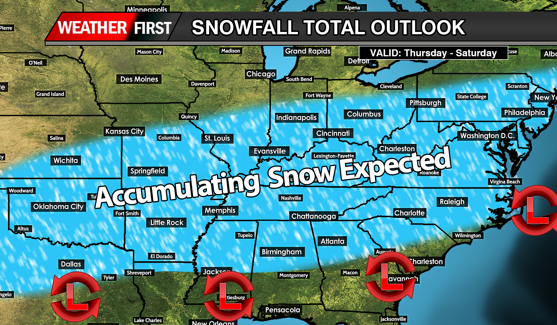
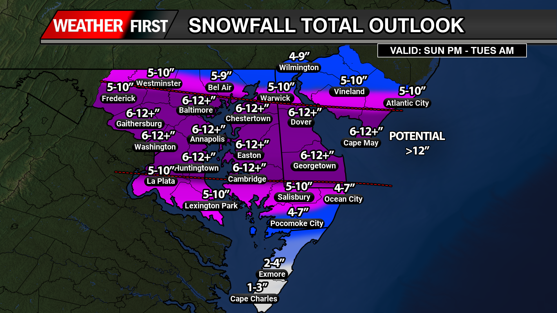
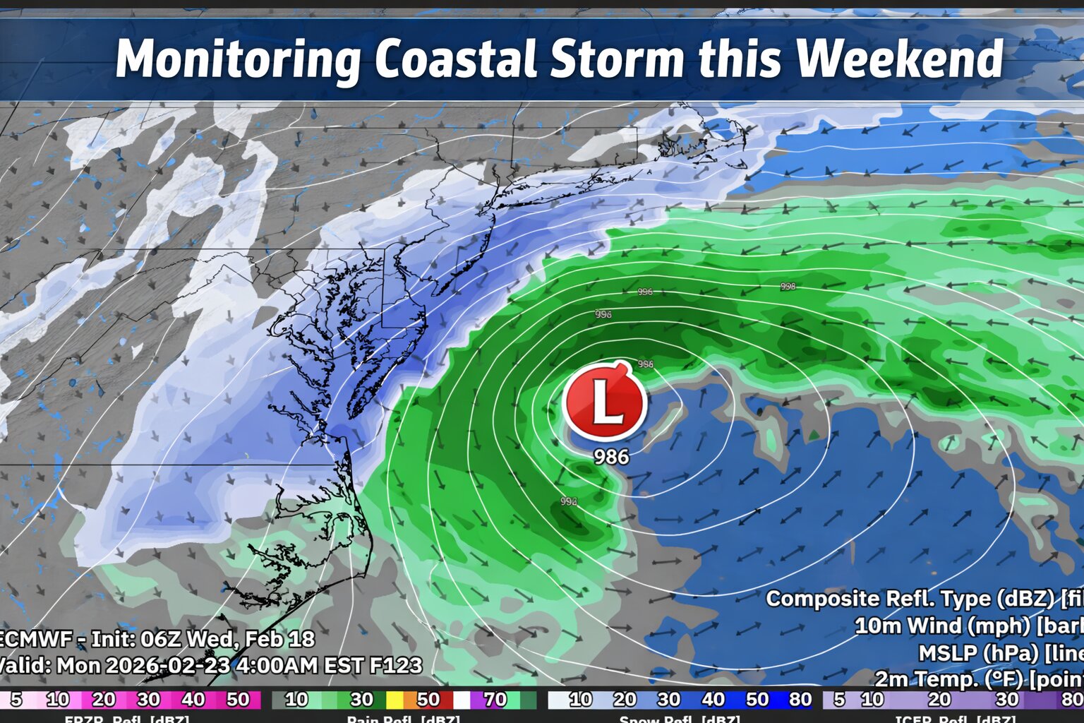
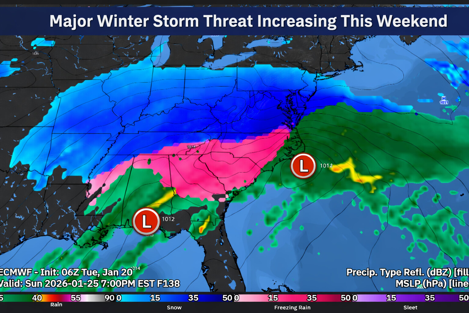
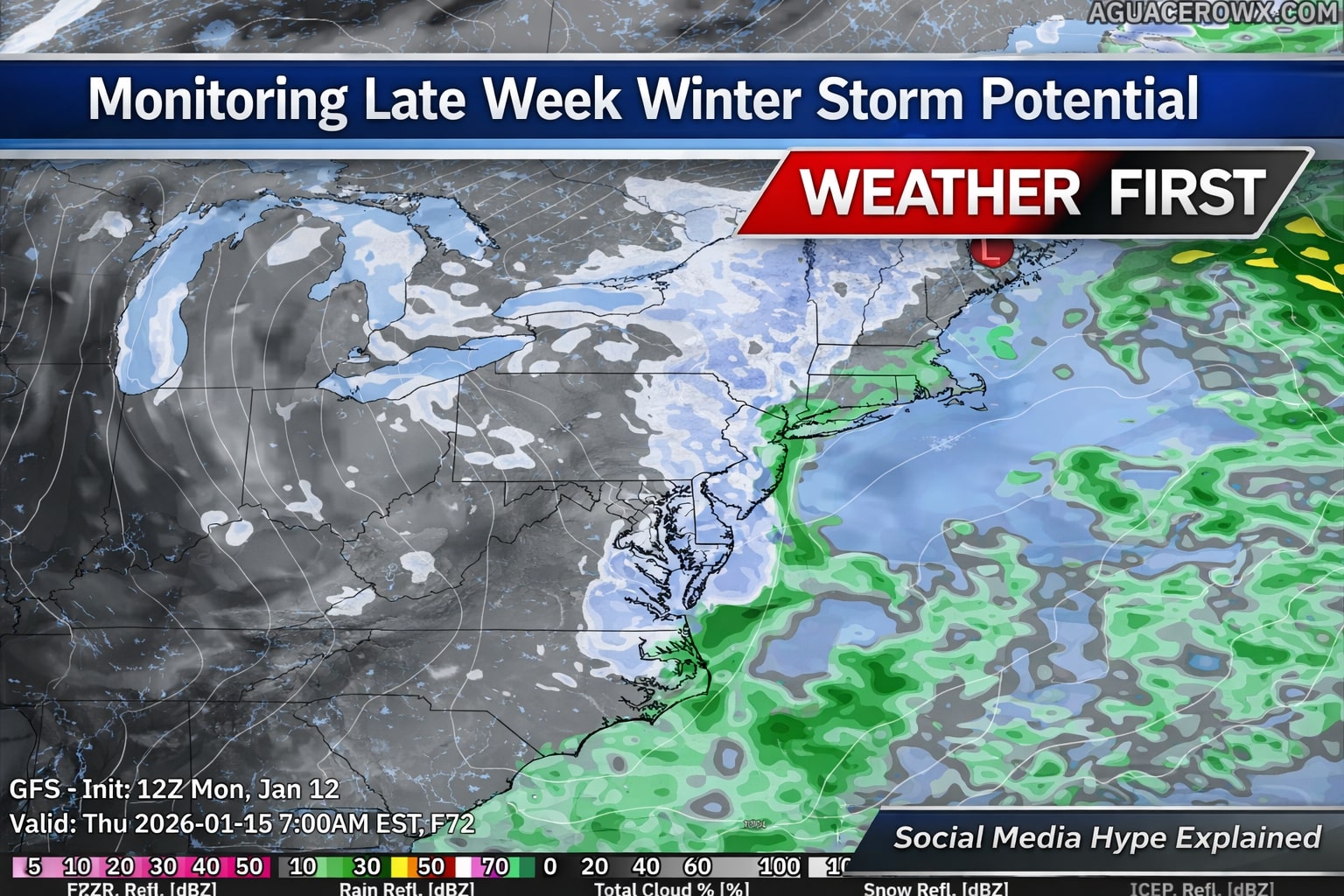
    A major and potentially historic winter storm is set to bring crippling snowfall, blizzard conditions, damaging winds, and significant coastal flooding to the Delmarva Peninsula and southern New Jersey through Monday.

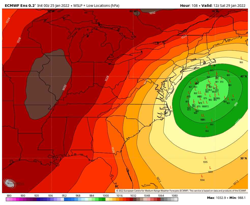
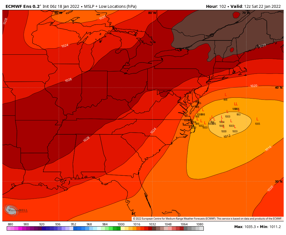
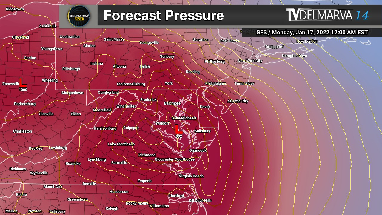
    The storm is rapidly intensifying as it tracks northeast along the Mid-Atlantic coast. Forecast guidance continues to show the low deepening dramatically offshore, potentially reaching near 970 millibars. This strengthening coastal system will place Delmarva and South Jersey in a prime zone for heavy snow, strong winds, and dangerous conditions.

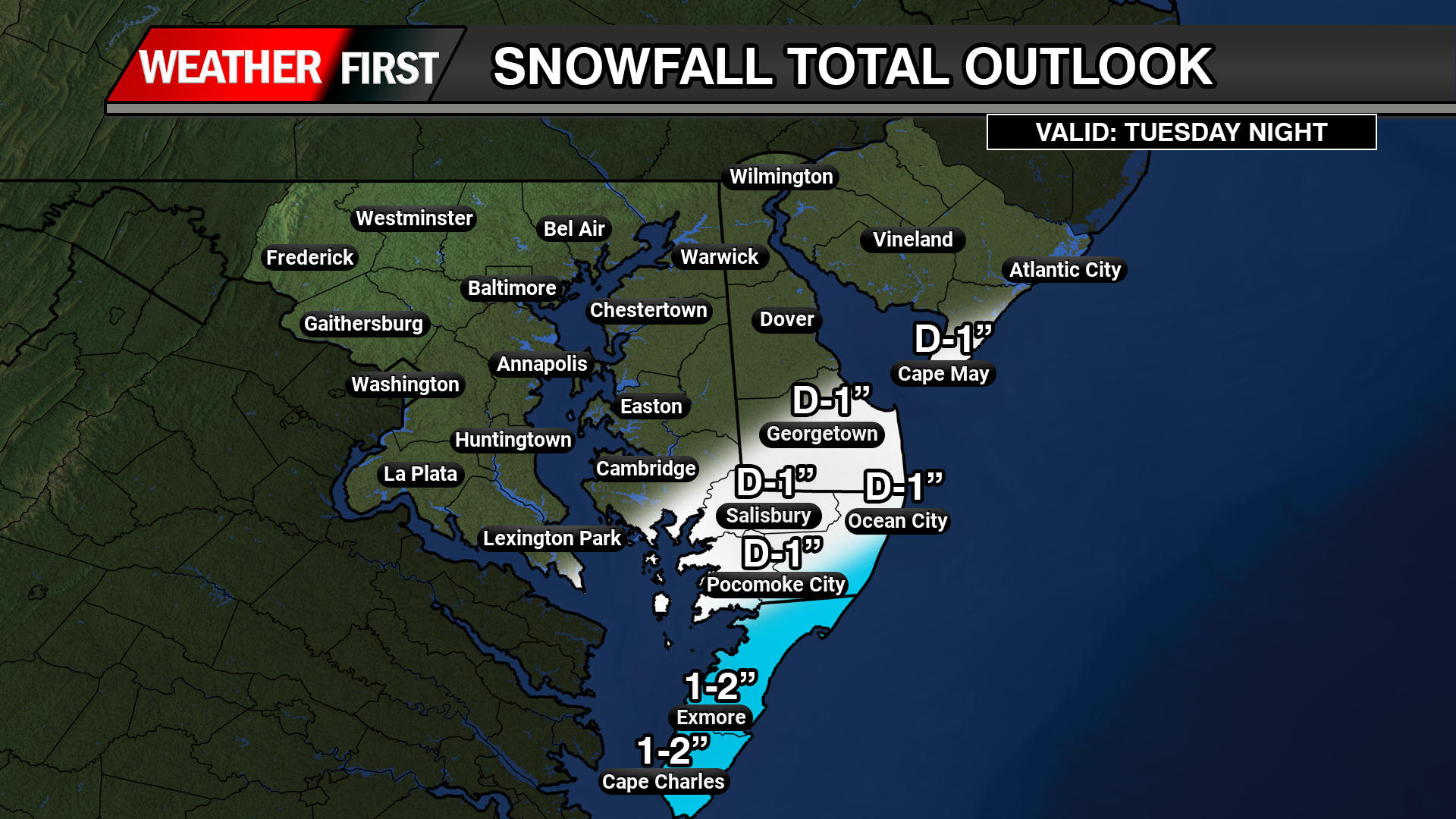
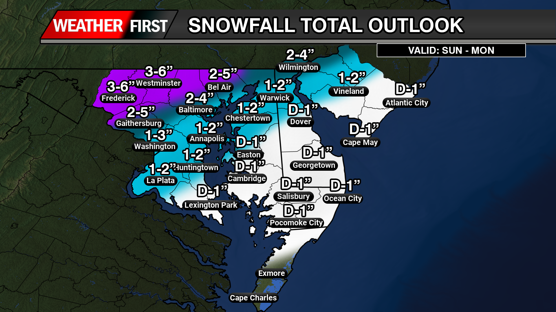
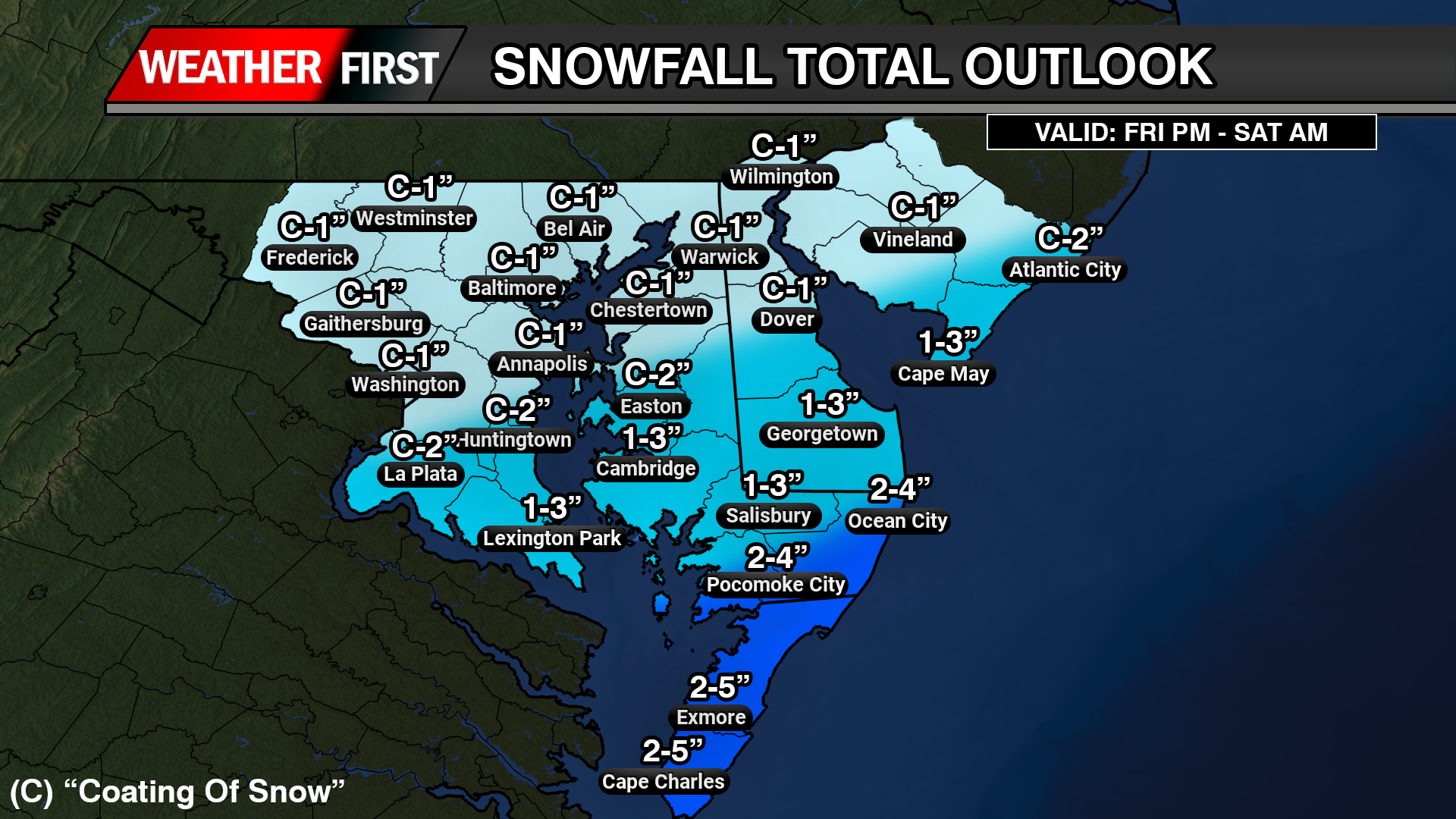
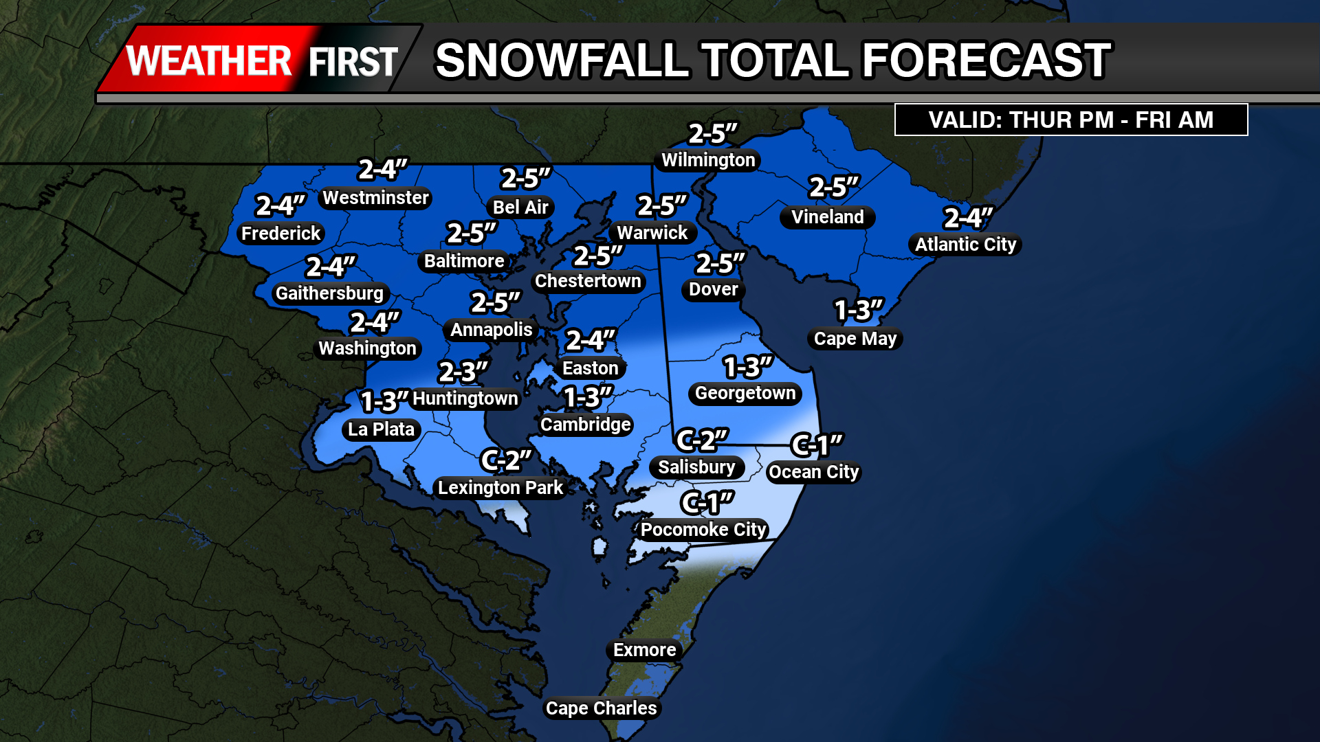
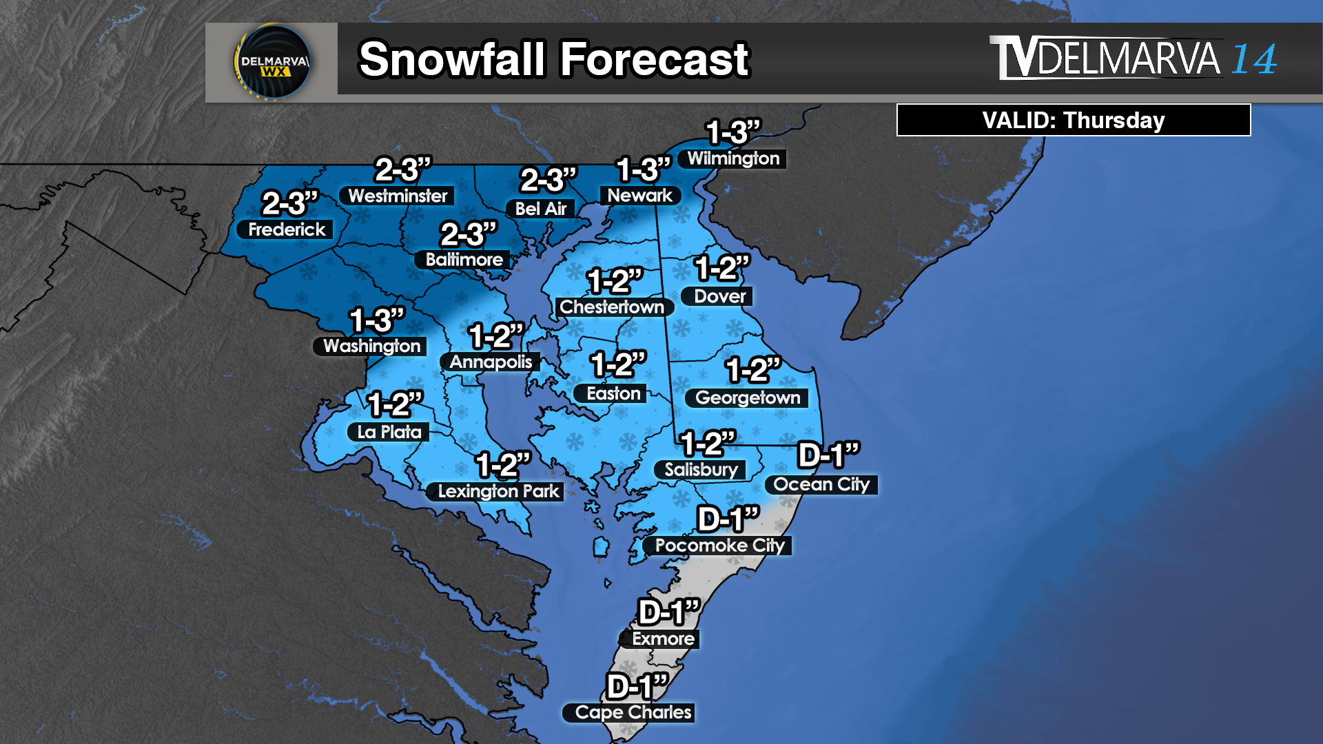
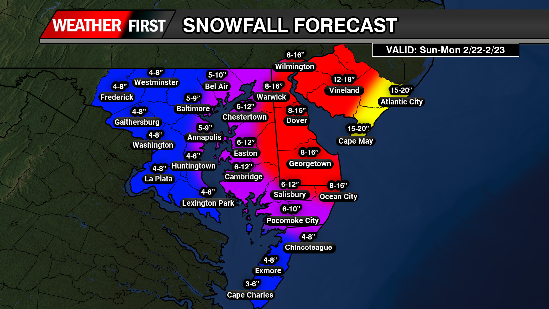
    Heavy Snow Becoming Intense This Evening

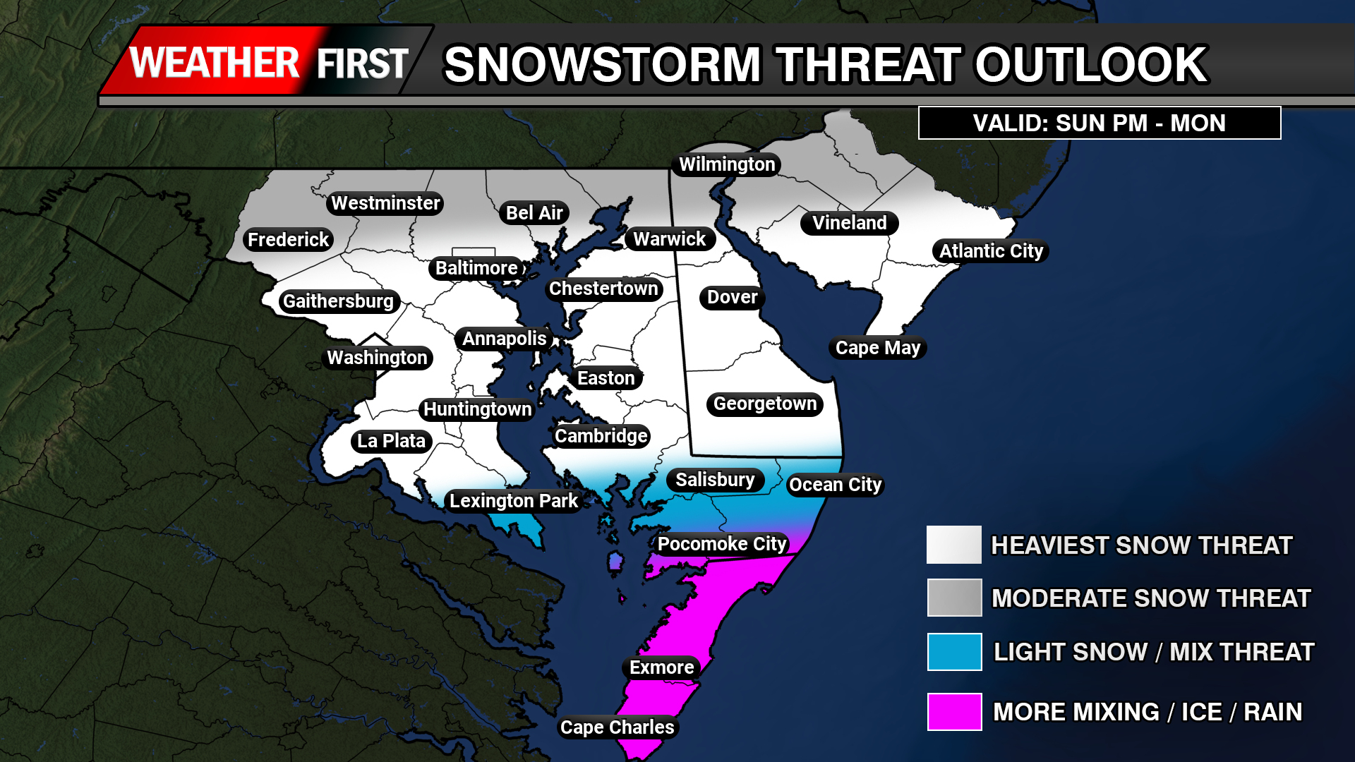
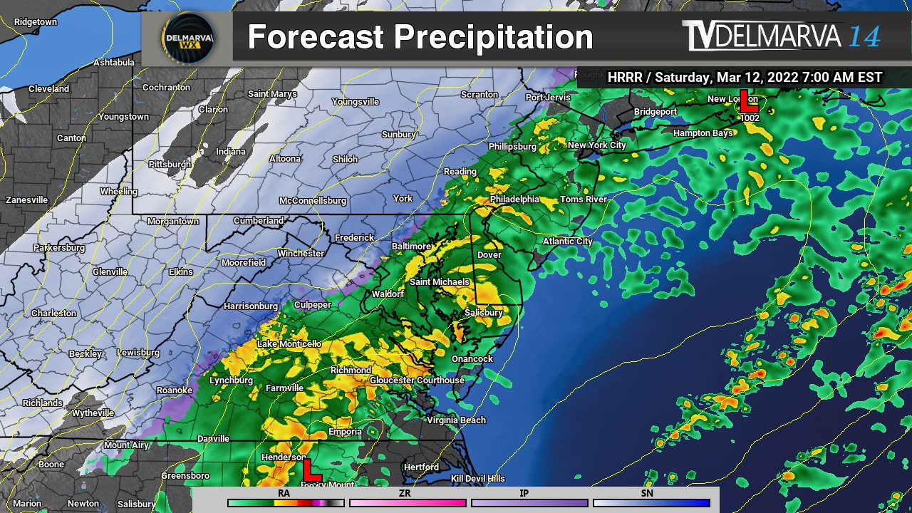
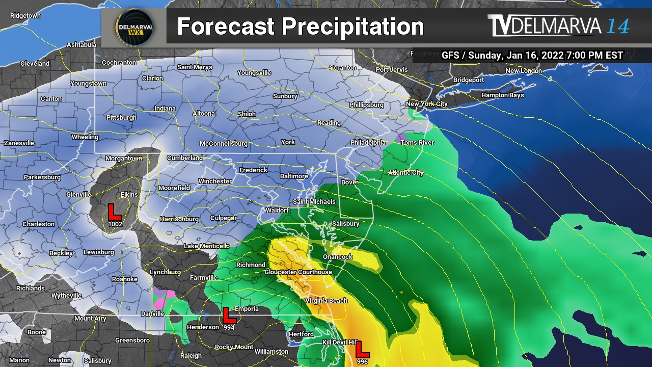
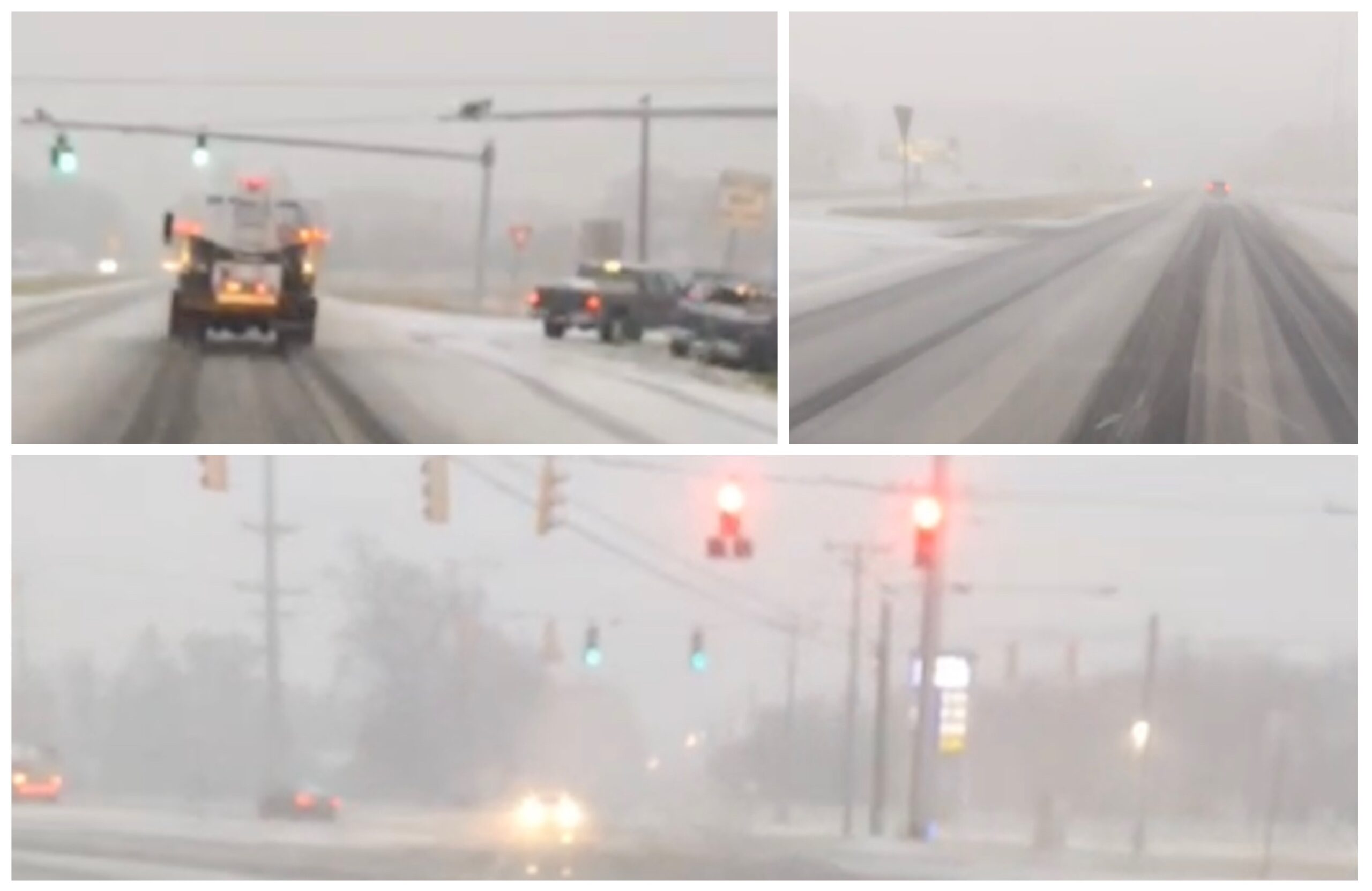
    Light precipitation is already spreading into the region, but colder air will quickly take over this afternoon and evening. Any early rain or mix will transition to all snow as the heaviest precipitation moves in.

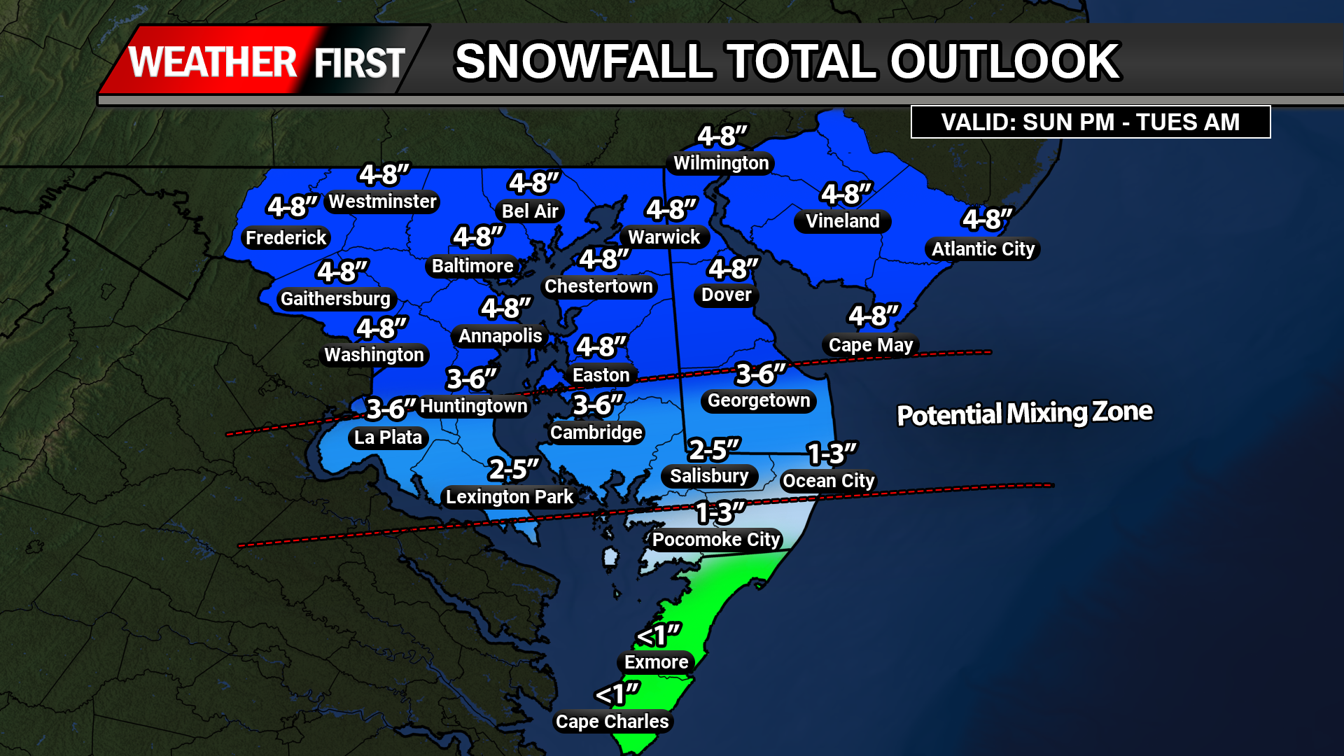
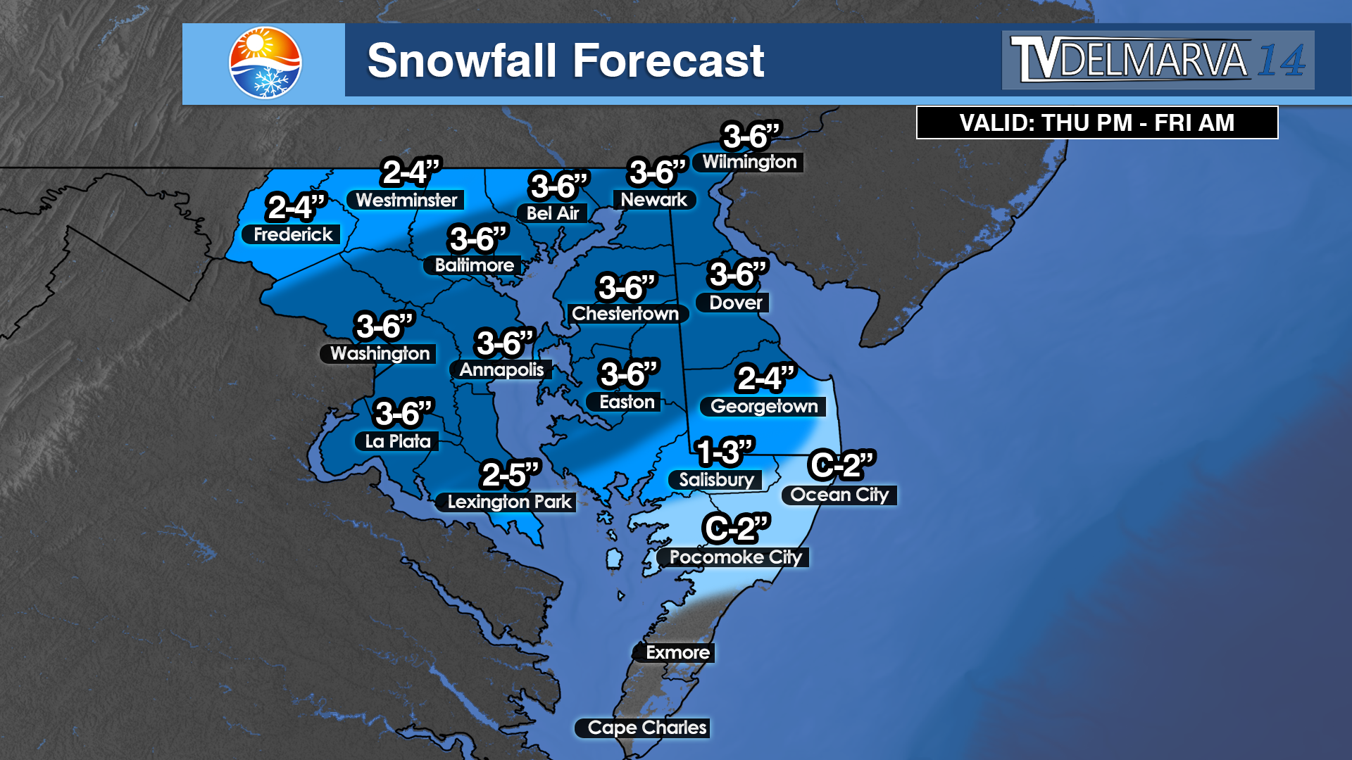
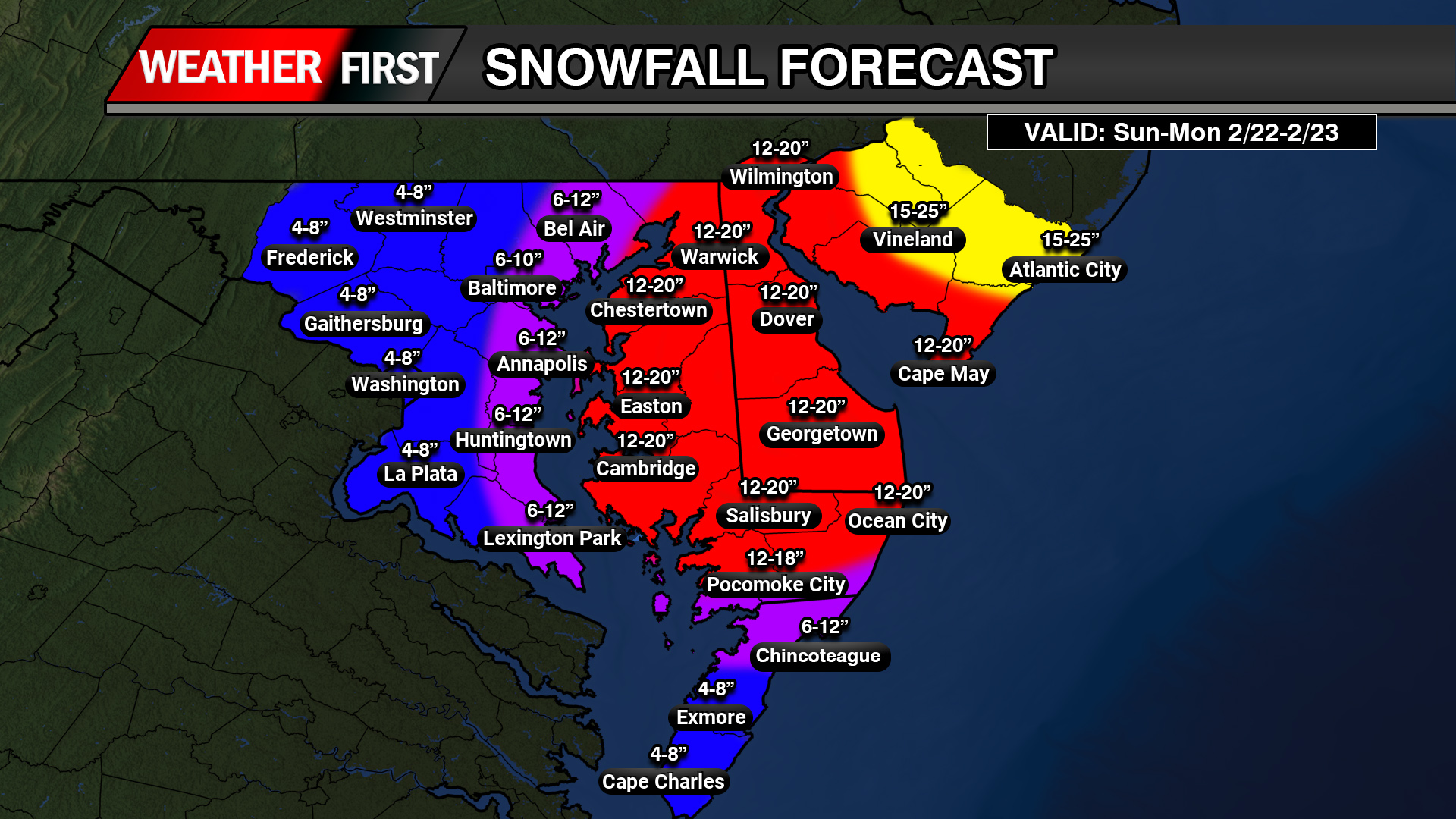
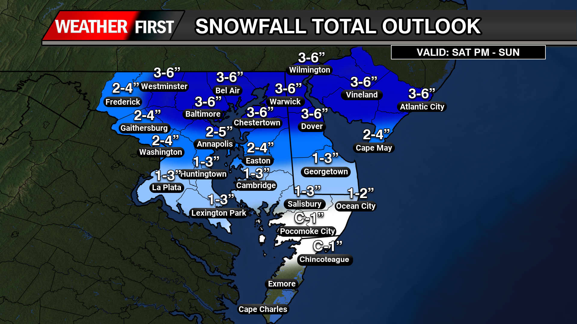
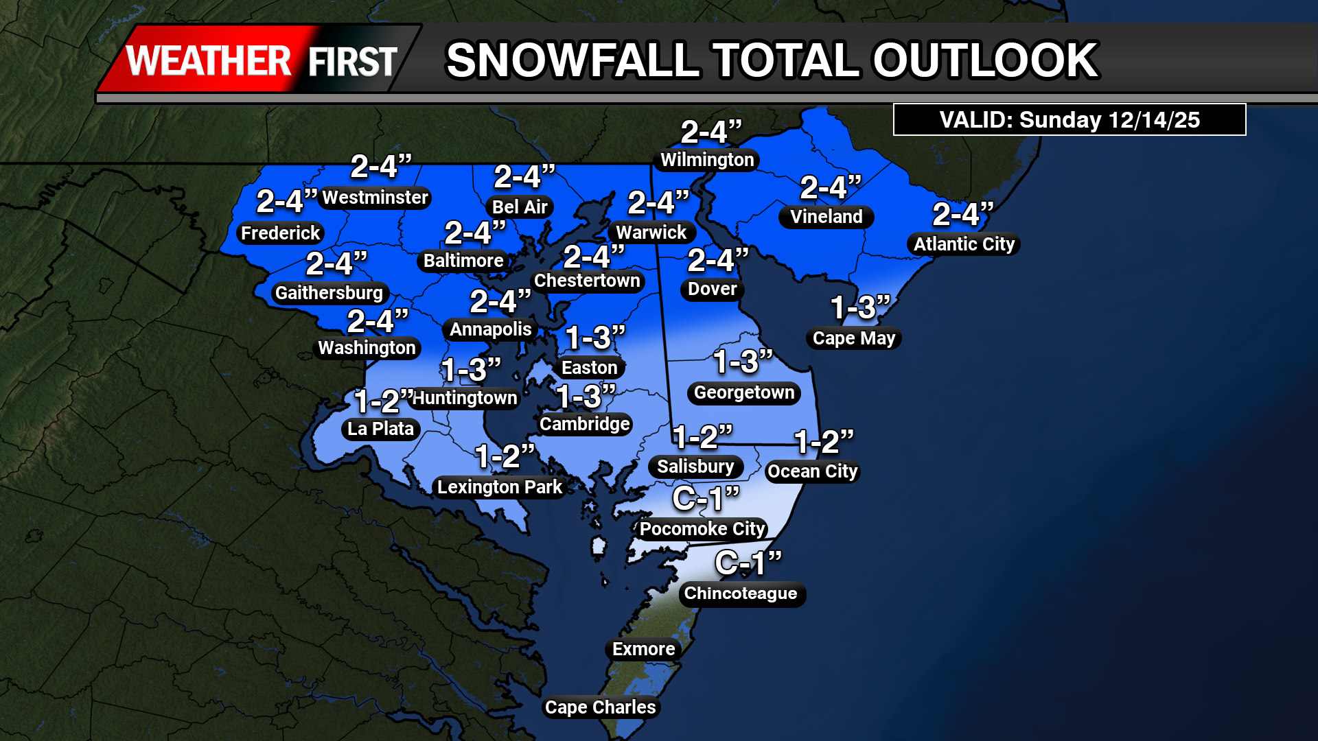
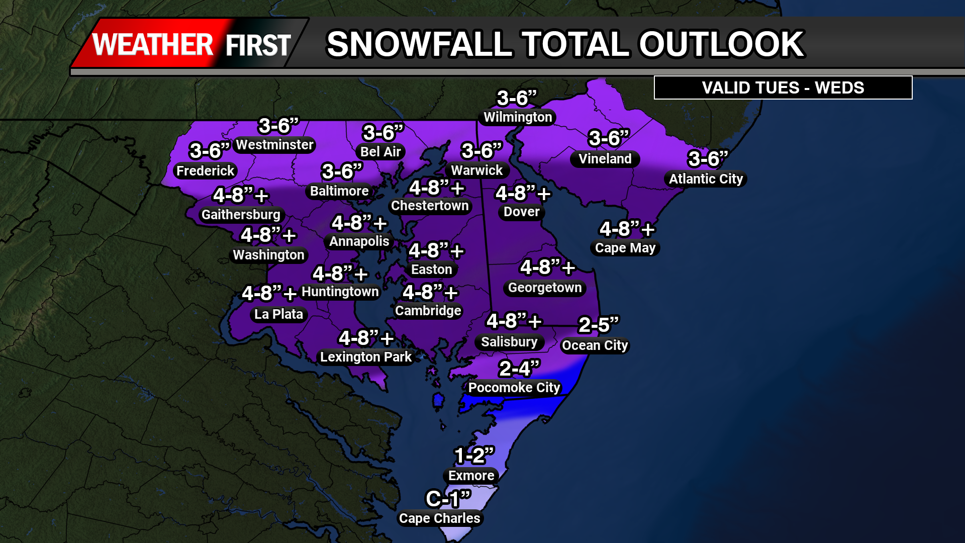
    Snowfall rates are expected to exceed 2 inches per hour at times tonight, especially across Delaware and southern New Jersey. Widespread totals of 1 to 2 feet are expected across much of Delmarva, with locally higher amounts possible near the Delaware and New Jersey coasts where banding sets up.

    Southern New Jersey is expected to see some of the heaviest snowfall, particularly along the coastal counties where intense snow bands may persist for several hours.

    Thundersnow Possible Tonight

    With very strong upward motion in the atmosphere and intense snow bands developing, thundersnow is possible tonight across parts of Delmarva and southern New Jersey. This rare phenomenon occurs when lightning and thunder develop within heavy snow bands, often signaling extremely heavy snowfall rates and rapidly deteriorating visibility.

    If thundersnow develops, snowfall rates could briefly become even more intense, leading to near whiteout conditions.

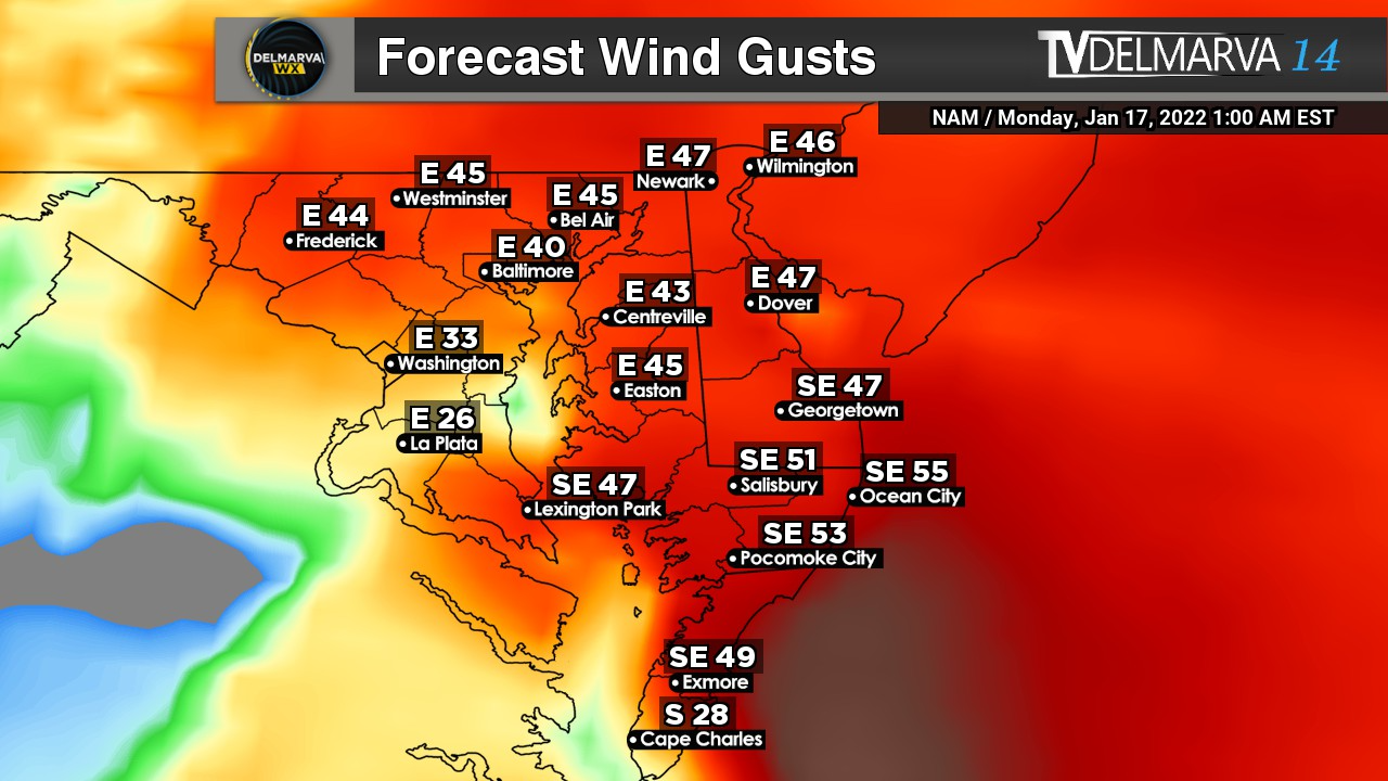
    Blizzard Conditions and Life-Threatening Travel

    As the storm strengthens offshore tonight, winds will ramp up significantly. Northeast winds of 20 to 35 mph will shift north and northwest into Monday, with gusts of 35 to 45 mph inland and up to 60 mph along the coast.

    The combination of heavy, wet snow and strong winds will produce blowing and drifting snow, sharply reduced visibility, and potentially impossible travel conditions. Blizzard Warnings are in effect across all of Delaware and all of New Jersey.

    Even outside of strict blizzard criteria, travel is expected to become extremely dangerous Sunday night into early Monday. Residents are strongly urged to avoid travel once conditions worsen.

    Power Outages Likely

    Snow will initially be heavy and wet, sticking to trees and power lines. Combined with strong wind gusts, this increases the risk for scattered power outages across the region.

    Coastal Flooding Expected Tonight

    In addition to snow and wind, widespread coastal flooding is expected during tonight’s high tide cycle.

    Strong onshore winds will push water into the back bays and along the Atlantic coastline of southern New Jersey and Delaware. Moderate coastal flooding is likely, with some locations potentially reaching major flood stage, especially from Ocean County, New Jersey southward through Sussex County, Delaware.

    Coastal Flood Warnings remain in effect for Atlantic and Cape May Counties in New Jersey and for Kent and Sussex Counties in Delaware.

    Another round of minor to moderate flooding may occur Monday as ocean swells remain elevated, even as winds gradually shift offshore.

    No Tidal Flooding for Maryland Eastern Shore Rivers

    While Atlantic coastal areas face significant flooding concerns, tidal flooding is not expected along the tidal Maryland Eastern Shore waterways.

  • Major Nor’easter to Bring Blizzard Conditions to Delmarva Sunday into Monday

    Major Nor’easter to Bring Blizzard Conditions to Delmarva Sunday into Monday

    A powerful late-February nor’easter is expected to significantly impact the Delmarva Peninsula from Sunday afternoon through Monday evening, bringing heavy snow, strong winds, and potentially dangerous travel conditions.

    This storm will rapidly intensify off the Mid-Atlantic coast, creating a period of heavy snowfall and localized blizzard conditions across coastal Delaware and portions of inland Sussex County.

    Heavy Snow and Strong Winds

    Snow is expected to overspread Delmarva Sunday afternoon, becoming heavy at times Sunday night into early Monday. Snowfall rates could exceed one to two inches per hour during the height of the storm.

    Total accumulations across parts of the peninsula could reach significant levels, especially closer to the Delaware beaches, where blowing and drifting snow may greatly reduce visibility.

    In addition to heavy snowfall, strong northeast winds are expected to increase through Sunday night. Wind gusts between 40 and 60+ mph could create whiteout conditions, particularly along coastal areas. These winds will also lead to significant drifting, making roads impassable in some locations.

    Travel Could Become Extremely Dangerous

    The combination of heavy snow and strong winds may produce localized blizzard conditions across coastal Delmarva. Visibility could drop below a quarter mile at times, especially during peak snowfall rates.

    Travel is expected to become very difficult Sunday night into Monday. Both the Monday morning and evening commutes could be heavily impacted if conditions worsen as expected.

    Residents are urged to limit travel to emergencies only. If travel is unavoidable, motorists should carry a winter survival kit and be prepared for rapidly deteriorating conditions.

    Power Outages Possible

    Strong winds combined with heavy, wet snow could lead to scattered power outages across Sussex County and nearby coastal communities. Tree damage is possible, particularly where snowfall accumulates on limbs before peak wind gusts arrive.

    Coastal Concerns

    Moderate coastal flooding and beach erosion are also possible along the Delaware coastline, especially during times of high tide as strong onshore flow persists.

  • Potential Coastal Storm This Weekend; Much Colder Air Follows for Delmarva

    Potential Coastal Storm This Weekend; Much Colder Air Follows for Delmarva

    An active weather pattern continues across the Mid-Atlantic, and are now monitoring the potential for a coastal storm to impact the Delmarva Peninsula during the second half of the weekend.

    While details remain uncertain, confidence is increasing that a developing area of low pressure will track west to east across the region late Sunday before strengthening offshore along the northern Mid-Atlantic coast. But there is also key details I’m not very fond of trusting.

    Storm Track Will Determine Impacts

    Most computer models show a storm developing and passing near the region Sunday. However, the exact track and strength of the surface low will ultimately determine how impactful this system becomes for Delmarva.

    Recent trends in both deterministic and ensemble guidance have nudged the system slightly farther south and east. That shift could reduce overall impacts totals locally if it continues. Still, there remains a signal for a widespread precipitation event across the peninsula.

    If the storm tracks close enough to the coast, stronger dynamics could enhance precipitation rates. At this stage, it is too early to determine rain and even snowfall amounts or pinpoint exact impacts.

    Cold Air Will Be Key

    The amount of cold air in place ahead of and during the storm will play a major role in determining precipitation type and accumulation potential.

    Forecast guidance suggests that sufficient cold air may be present for accumulating snow across Delmarva if the storm tracks favorably. However, small shifts in the storm’s path could significantly change the outcome.

    Relying On a Norlun Trough & Dynamic Cooling Never Fair Well For Delmarva

    A Norlun trough is a narrow, elongated area of low pressure that can develop between two larger weather systems, often in New England or the northern Mid-Atlantic.

    These features often form in cold, unstable air behind a departing coastal storm or between competing pressure systems. They can be difficult to forecast because they are small-scale and highly sensitive to subtle atmospheric changes.

    On Delmarva, Norlun troughs are less common than in New England, but similar narrow deformation bands can produce comparable localized snowfall.

    Dynamic cooling refers to a process where strong upward motion in the atmosphere causes temperatures to cool rapidly, sometimes enough to change rain to snow.

    If precipitation falls heavily enough, it can also contribute to cooling through melting and evaporation, reinforcing the transition to snow.

    Much Colder Air Early Next Week

    Behind the potential weekend storm, a notably colder air mass is expected to settle into the region early next week.

    High temperatures Monday and Tuesday may struggle to climb out of the 30s across Delmarva, with overnight lows dropping into the teens in many locations. The colder conditions could lead to icy spots lingering if snowfall occurs over the weekend.

  • Coastal Winter Storm to Bring Snow, Wind, and Tidal Concerns to Delmarva This Weekend

    Coastal Winter Storm to Bring Snow, Wind, and Tidal Concerns to Delmarva This Weekend

    A rapidly intensifying coastal storm is expected to develop off the East Coast this weekend, bringing a combination of snow, strong winds, and coastal flooding concerns to parts of the Delmarva Peninsula. While the storm is forecast to track far enough offshore to limit widespread impacts inland, coastal and southern portions of Delmarva remain at risk for more significant winter weather impacts.

    Snowfall Forecast

    Snowfall amounts across Delmarva will feature a very sharp gradient, with accumulations increasing quickly from north to south and from inland areas toward the coast.

    Northern and central Delaware, along with much of interior Maryland’s Eastern Shore, are expected to see little accumulation, generally less than 1 inch. This includes areas such as Dover, Easton, and much of inland Kent and Queen Anne’s counties.

    Across central Delmarva, including Cambridge and Georgetown, snowfall totals are forecast to range from a coating up to around 1 inch, with 1 to 3 inches possible near Salisbury.

    The highest snowfall totals are expected along the coast and across southern Delmarva. Ocean City could see 2 to 5 inches of snow, while farther south, Pocomoke City is forecast to receive 3 to 6 inches. The most significant accumulations are expected across Chincoteague, Exmore, and Cape Charles, where 4 to 8 inches of snow remain possible.

    We stress that even small shifts in the storm’s track could result in noticeable changes to snowfall totals, especially along the northern edge of the heavier snow band.

    Timing and Impacts

    Snow is expected to develop Saturday night, with the highest confidence for accumulation occurring overnight into Sunday morning. Snow should gradually taper off from west to east by late Sunday morning.

    Strong winds will become an increasing concern early Sunday morning through Sunday evening, coinciding with the period of rapid storm intensification offshore. Gusts along the Delmarva coastline could approach or exceed 55mph, especially in exposed coastal locations.

    The combination of snow and strong winds could lead to blowing and drifting snow, particularly in southern Delaware and along the coast. These conditions may reduce visibility and create hazardous travel, even where snowfall totals are not extreme.

    Coastal Flooding Concerns

    At least minor tidal flooding is possible during the high tide cycle on Sunday, with some impacts potentially lingering into Monday. While wind direction is expected to limit more severe flooding, higher astronomical tides associated with the full moon, combined with increasing offshore swells, may exacerbate water level rises.

    Additional complications include existing ice on bays and waterways, which could influence how water levels respond during high tide.

    Forecast Confidence

    Confidence is increasing that Delmarva will experience impacts from this winter storm, though confidence in exact snowfall placement remains below average. The storm is expected to remain offshore, but a shift of as little as 50 miles could significantly change snowfall totals across the peninsula.

    Residents across Delmarva, especially in coastal and southern communities, are urged to monitor the forecast closely as additional updates and potential advisories may be issued over the next 24 hours.

  • Major Winter Storm Becoming Likely Across Southern Delmarva; Blizzard Conditions Possible

    Major Winter Storm Becoming Likely Across Southern Delmarva; Blizzard Conditions Possible

    A rapidly intensifying coastal storm is expected to develop off the East Coast this weekend, and while confidence in exact impacts remains limited, portions of the Delmarva Peninsula could see effects ranging from snowfall and strong winds to coastal flooding.

    Forecast guidance continues to show cyclogenesis beginning Saturday off the southeastern United States coast. As low pressure rapidly deepens, the system is expected to track north and east Saturday night into Sunday. This development is being driven by a potent upper-level disturbance rotating around the base of a longwave trough over the eastern United States, interacting with a sharp temperature contrast along the coast.

    For Delmarva, impacts will depend heavily on the exact track of the storm, which remains uncertain. Current guidance places much of the region on the northwest fringe of the precipitation shield. Small shifts in the storm’s path could make the difference between limited impacts and a more impactful winter weather event, particularly for southern and coastal Delaware.

    Among the latest forecast models, solutions remain mixed. Some guidance continues to suggest light snowfall for parts of Delaware, while others are more suppressed and keep meaningful precipitation offshore. At this time, forecast confidence supports the possibility of light to moderate snow accumulations in southern Delaware, with lesser amounts farther north. Additional snow could fall beyond early Sunday depending on how quickly the system departs.

    Snowfall probabilities remain highest closer to the coast. Current probabilistic guidance shows a 60 to 70 percent chance for more than 2 inches of snow near coastal areas, decreasing to 25 to 35 percent near the I-95 corridor. The probability of 6 inches or more remains lower, but remains notable near the coast where probabilities range from 35 to 50 percent.

    Regardless of snowfall totals, confidence is increasing that strong winds will affect the region Saturday night into Sunday. Northerly to northeasterly winds are expected to increase inland to 15 to 25 mph with gusts up to 35 mph. Along the coast, winds could reach 25 to 35 mph with gusts approaching 50 mph. If the storm tracks closer to the coast, winds could be stronger than currently forecast.

    Given the combination of strong winds and falling or blowing snow, there is a conditional risk for blizzard conditions in portions of southern Delmarva, especially near coastal areas. While confidence is not yet high enough for blizzard headlines, blizzard warnings could become necessary if the storm track shifts closer and snowfall rates increase alongside the strongest winds.

    Strong onshore winds will also increase the risk for coastal flooding, particularly during times of high tide. This threat is further heightened by the presence of a full moon, which will result in astronomical high tides. If strong northeasterly winds persist during peak tidal cycles, water levels could rise more quickly and lead to minor to locally moderate coastal flooding in vulnerable coastal communities.

    Temperatures throughout the event will be well below freezing, strongly favoring all snow across Delmarva should precipitation occur. Any snowfall that does develop would accumulate efficiently on untreated roads and elevated surfaces.

    The storm is expected to pull rapidly away to the northeast by Sunday evening, allowing quieter but cold conditions to return for the start of the new week.

    Overall, this remains a challenging forecast. While many model solutions currently suggest a near miss for Delmarva, even a subtle shift in the storm track could bring more substantial impacts. Residents are encouraged to stay informed, review winter weather safety plans, and monitor future forecasts as confidence improves over the coming days.

  • Rapidly Intensifying Coastal Storm Could Impact the Region This Weekend

    Rapidly Intensifying Coastal Storm Could Impact the Region This Weekend

    We are closely monitoring a rapidly strengthening coastal storm expected to develop off the East Coast this weekend. While confidence in the exact track and impacts remains low, the system has the potential to bring moderate to significant winter weather impacts to parts of the region, including snow, strong winds, and coastal flooding.

    Forecast guidance continues to show low pressure rapidly developing off the southeastern U.S. coast on Saturday before intensifying and moving north and east Saturday night into Sunday. This storm will strengthen as a powerful upper level disturbance rotates around the base of a large-scale trough over the eastern United States and interacts with a strong temperature contrast along the coastline. This setup is favorable for rapid intensification, which could lead to high-impact weather depending on the storm’s eventual track.

    One of the reasons forecast confidence remains limited is ongoing difficulty within some weather models in accurately handling the storm’s development. Several models are struggling with an issue known as convective feedback. This occurs when the model generates unrealistic high vertical velocities that are too strong or widespread, which in turn creates artificial areas of low pressure that should not exist. These false low pressure centers can disrupt the overall storm structure, leading to errors in the placement of the main low and causing the precipitation shield to appear displaced or unrealistic compared to what may actually occur.

    As a result, small but important details such as where the heaviest snow sets up and how far inland precipitation reaches remain uncertain. This has contributed to notable spread among model solutions, particularly regarding how close the storm tracks to the coast.

    If the storm tracks closer to shore, impacts could begin as early as late Saturday, with the most significant conditions occurring Saturday night into Sunday morning. With very cold air firmly in place at both the surface and aloft, any precipitation that reaches the region would almost certainly fall as snow.

    Probabilistic snowfall data suggests a moderate risk for accumulating snow. The likelihood of at least 2 inches of snow is around 50 percent near the coast and roughly 40 percent along the I-95 corridor, with lower probabilities farther inland. The chance of 6 inches or more increases closer to the coast, reaching around 40 percent, while remaining near 30 percent around the urban corridor. These probabilities remain subject to change as confidence improves.

    Regardless of snowfall totals, increasing winds appear likely. Northerly to northeasterly winds are expected to strengthen Saturday night into Sunday, with gusts of 25 to 35 mph inland and up to 50 mph along the coast. A closer track could result in even stronger winds, raising the risk for power outages, minor structural damage, and hazardous marine conditions. The strong wind field may also contribute to coastal flooding as water is pushed toward the shoreline.

    By Sunday evening, the storm is expected to rapidly pull away to the northeast, with quieter but cold conditions settling in for early next week.

    This storm remains one to watch closely over the coming days. Forecast details should become clearer as additional data is sampled and models better resolve the system. Residents are encouraged to stay informed and prepared for potential winter weather impacts this weekend.

  • Growing Threat of Significant Winter Storm for Delmarva This Weekend

    Growing Threat of Significant Winter Storm for Delmarva This Weekend

    Forecast confidence is increasing that a potentially impactful winter storm could affect the Delmarva region late Saturday through Sunday, though important details regarding track and snowfall amounts remain uncertain at this time.

    Weather patterns aloft are becoming increasingly active as we head toward the weekend, with interactions expected between northern and southern jet stream systems. The energy driving this setup is currently located over the Arctic and the Pacific Ocean, meaning it will take several more days for forecasts to fully resolve how this system evolves. Even so, most forecast guidance now consistently shows an area of low pressure developing near Texas on Friday before moving east along the Gulf Coast into Saturday.

    As the system approaches the East Coast, guidance generally favors the low tracking northeast toward the North Carolina coast before moving offshore late Sunday into early Monday. This type of track would place Delmarva on the colder, northern side of the storm, increasing the potential for winter weather impacts across the region. A key question remains how close the storm tracks to the coastline, as even small shifts could have a major influence on snowfall totals.

    A strong arctic high pressure system will be positioned to the north, supplying cold air into the Mid Atlantic. Earlier forecast guidance suggested this high might suppress the storm farther south, limiting impacts locally. However, trends over the past 12 to 24 hours show the storm track edging farther north, increasing the likelihood that precipitation spreads into Delmarva.

    Snow probabilities have responded accordingly. Current guidance now indicates a 75 to 95 percent chance of at least 2 inches of snow and a 70 to 85 percent chance of 6 inches or more for areas along and south of the Interstate 95 corridor, with probabilities decreasing farther north.

    Even more impressive with NBM blends of >12 inches of snow are between 50-60% as of this morning. These numbers are notably higher than those from previous forecast cycles and point toward a growing signal for a meaningful winter weather event.

    If this storm materializes, snowfall could begin late Saturday and continue through Sunday, with the potential for lingering impacts into Monday depending on how quickly the system moves away. While confidence in exact snowfall totals remains low, the overall signal for a winter storm affecting at least part of Delmarva is stronger than typically seen at this lead time.

    It is important to note that East Coast winter storms often produce narrow bands of heavy snow, sometimes only 50 to 100 miles wide. With the storm’s key ingredients still thousands of miles away, it is far too early to determine which specific locations will see the highest accumulations. Residents across Delmarva should continue to monitor forecast updates closely over the coming days as details become clearer.

  • Unsettled Weekend Weather Ahead; Coastal Storm Threat Diminishing

    Unsettled Weekend Weather Ahead; Coastal Storm Threat Diminishing

    A developing storm system will bring a period of light snow early Saturday morning before transitioning to rain for many locations as the day goes on. The highest chances for accumulating snow will be found near and northwest of the Interstate 95 corridor, with the greatest totals expected farther north.

    An upper level trough will be positioned over the eastern United States this weekend, allowing several smaller disturbances to move through the region. The first of these systems is expected to arrive during the pre dawn hours on Saturday. As it moves in, increasing lift in the atmosphere and a gradual influx of milder air aloft will help precipitation develop.

    Forecast guidance now suggests the system will be slightly more organized than previously expected. As a result, rainfall totals have increased modestly. Areas near and northwest of I 95 are expected to receive between one tenth and two tenths of an inch of liquid precipitation through Saturday, while locations southeast of I 95 are likely to remain under one tenth of an inch.

    Precipitation is expected to begin mainly as snow early Saturday before gradually changing to rain from southeast to northwest. Little to no snow accumulation is expected southeast of the I 95 corridor before the transition occurs. Near and just northwest of I 95, snowfall amounts should range from a light dusting up to one inch.

    Farther north, including the Lehigh Valley, northwest New Jersey, and the southern Poconos, colder air will allow snow to persist longer. In these areas, snowfall totals are now forecast to reach one to two inches, with up to three inches possible at higher elevations in the southern Poconos where rain mixing may be limited.

    Watching a Coastal System for Sunday

    Attention then turns to a separate storm system expected to develop offshore late in the weekend. This coastal low is forecast to form near the Outer Banks and track northeastward on Sunday. At this time, the overall threat for a significant snowfall remains low.

    Most forecast models continue to favor a track well offshore, which would limit impacts across the region. Under the current forecast, light snow is possible along the coast and areas south and east of I 95 on Sunday, while locations farther inland may see little or no accumulation.

    There is still some uncertainty, as a small number of ensemble models suggest a closer track could occur. However, confidence in that scenario remains low. Probabilities for advisory level snowfall remain modest, generally around 20 to 25 percent at the immediate coast, decreasing farther inland.

    Current snowfall forecasts call for around one half inch to one and a half inches along the coast and southern Delaware, with a coating to one inch possible up to the I 95 corridor. North and west of I 95, only a few flurries or trace amounts are expected.

    Any precipitation associated with this system is expected to taper off Sunday night as the storm pulls farther offshore.

  • Unsettled Weekend Weather Possible Across Delmarva As Coastal System Develops With Snow Threat

    Unsettled Weekend Weather Possible Across Delmarva As Coastal System Develops With Snow Threat

    Residents across the Delmarva region will want to stay weather aware this weekend as multiple rounds of precipitation are possible, including the potential for snow. Forecast confidence remains moderate to low, but the overall pattern supports unsettled conditions from Saturday through Sunday night.

    A broad area of low pressure aloft, known as a longwave trough, will settle over the eastern United States this weekend. Several smaller disturbances moving through this pattern will help generate periods of precipitation, beginning early Saturday and possibly continuing into Sunday night.

    The first system is expected to move through Saturday morning and appears to be relatively weak. Precipitation may begin near or shortly after daybreak, when temperatures are at their coldest. Some locations could see a brief mix or light snow at the onset, especially inland areas, before temperatures rise through the morning. As daytime heating and weak warm air move in, most of Delmarva should transition to light rain. Any snow accumulation during this first round is expected to be minimal, with little more than a trace for most areas. Overall precipitation amounts should remain under a tenth of an inch.

    Attention then turns to a second system that could develop offshore late Sunday into Sunday night. This system carries more uncertainty and higher potential impacts, depending largely on how close the surface low tracks to the coast. Recent forecast guidance has shown a slight shift toward a closer approach, which has increased the chance for precipitation across the region, especially near coastal areas.

    With a cold front moving through Saturday night, colder air will be in place on Sunday. If the offshore low tracks close enough, much of the precipitation could fall as snow, particularly during the latter half of Sunday and into Sunday night. At this time, the probability of seeing measurable snow across coastal Delmarva is around 35 to 50 percent (of greater than 1″), with lower chances farther inland. The likelihood of higher snowfall amounts remains low, but it cannot be ruled out if the storm trends closer to the coast.

    While confidence has increased slightly compared to earlier forecasts, there is still considerable uncertainty regarding the exact track and strength of this system. Residents across Delmarva should continue to monitor the forecast through the weekend, as small changes in storm position could significantly impact precipitation type and amounts.

    More updates will be provided as forecast confidence improves.

  • Will It Storm Or Will It Be Another Dud? The Talk About Sun-Mon Storm Signal

    Will It Storm Or Will It Be Another Dud? The Talk About Sun-Mon Storm Signal

    We are gearing up to be in a fairly hostile pattern with many pieces of energy to play with here over the next 2 weeks as a large long wave trough sits over the eastern US. The biggest issue right now is do they interact with each other or will they remain strung out wasting the potential for snow lovers out there.

    While the overall risk of impactful wintry weather remains low heading into early next week, colder temperatures mean even small changes in the forecast could introduce a chance for snow.

    A brief warm up to near seasonal levels is expected Saturday ahead of a passing cold front. Behind it, a colder pattern looks likely to settle back in and persist through at least the middle of next week, with temperatures running below normal. During this time, several weak disturbances are forecast to move through the region. While none of these systems appear particularly strong on their own, there is a possibility they could interact in a way that brings a wintry weather threat late Sunday into Monday.

    At this time, the most likely outcome would be flurries or light snow, with limited or no accumulation. However, if the shortwave has more of a interaction with the Jetstream, that can bring larger impacts. Forecast confidence remains low, with precipitation chances generally in the 20 to 30 percent range.

    Given the cold air in place, this period will need to be monitored closely for any changes that could increase the wintry weather threat. For now, the risk of a significant winter storm from Sunday into early next week remains low, but not zero.

  • Flash Freeze Risk Thursday Morning as Arctic Front Sweeps Through

    Flash Freeze Risk Thursday Morning as Arctic Front Sweeps Through

    A rapidly moving arctic cold front will create dangerous flash freezing conditions early Thursday morning, posing a significant hazard for travel across the region.

    Temperatures are expected to fall sharply from the 50s into the 20s in just a few hours as the front passes. Rain will transition to snow during this time, but the most serious concern will be the sudden freeze of wet roadways, sidewalks, and bridges.

    As colder air rushes in behind the front, any standing water from earlier rainfall will freeze almost instantly. This can lead to a thin but extremely slippery layer of ice forming with little to no warning. Bridges, overpasses, untreated roads, and shaded areas will be especially vulnerable to rapid icing.

    The timing of the temperature drop may coincide with the Thursday morning commute, increasing the risk for accidents and hazardous travel conditions. Even areas that see minimal snowfall could experience dangerous conditions due to ice forming faster than road crews can treat surfaces.

    Gusty winds behind the front will reinforce the cold air and cause wind chills to drop quickly, making conditions feel even colder by daybreak. Any snow that does fall will be brief, but it may further reduce visibility during the transition.

    Residents are urged to use caution if traveling early Thursday morning. Slowing down, allowing extra stopping distance, and remaining alert for icy patches will be critical. If possible, delaying travel until conditions improve later in the morning is strongly advised.

    Conditions are expected to stabilize later Thursday as precipitation ends, but cold temperatures will persist through the day.

  • Wintry Mix Followed By Arctic Cold To Finish Work Week

    Wintry Mix Followed By Arctic Cold To Finish Work Week

    A developing storm system will bring a brief period of light rain to Delmarva late Wednesday, with the potential for a few snowflakes before the precipitation ends early Thursday. While impacts from precipitation look minimal, the bigger story will be the sharp drop in temperatures and strong winds that follow and last into Friday.

    On Wednesday, a cold front associated with a passing system to our north will move through the region. This front will help produce a shield of light precipitation across the area Wednesday afternoon and evening. With temperatures starting off mild, most locations on Delmarva will see rain initially. As colder air moves in overnight, rain could briefly mix with or change to snow before ending early Thursday morning. Any snow accumulation is expected to be very light, with little to no impact expected across Delmarva.

    A secondary storm system is expected to develop offshore along the Carolina coast late Wednesday night into Thursday. Current forecast guidance keeps this system well offshore, meaning it should have little to no effect on our region. Because of this, confidence remains high that Thursday will be largely dry, aside from a small chance of lingering light precipitation early in the morning.

    Temperatures will be relatively mild ahead of the front on Wednesday, with highs ranging from the mid 40s to near 50 degrees across Delmarva. Conditions will change quickly Wednesday night as colder air pours into the region. By Thursday morning, temperatures will drop into the mid 20s to near 30 degrees. Strong west to northwest winds will develop, creating wind chills in the teens and lower 20s through much of the day.

    Thursday will feel bitterly cold and blustery, with sustained winds of 15 to 25 mph and gusts occasionally reaching 30 to 35 mph. Afternoon temperatures will struggle to recover, only reaching the upper 20s to mid 30s despite some sunshine.

    The coldest air arrives Thursday night into early Friday. Overnight lows will fall into the teens and lower 20s across Delmarva, and persistent winds will push wind chills into the single digits by Friday morning. Friday remains cold, with highs once again in the upper 20s to mid 30s and wind chills staying in the lower to mid 20s.

    While this system will not bring significant precipitation, the combination of strong winds and sharply colder temperatures will make it feel more like mid winter across Delmarva heading into the end of the week.

  • Winter Uncertainty Towards The Late Week; Social Media Hype Is Crazy Right Now

    Winter Uncertainty Towards The Late Week; Social Media Hype Is Crazy Right Now

    Forecast guidance continues to signal the potential for a disruptive winter weather pattern later this week, mainly from Wednesday through Friday, as an upper level low strengthens over the Lower Great Lakes and moves toward the Northeast. This system is expected to bring an increase in wintry precipitation across parts of the Lower Great Lakes, the central Appalachians, and portions of the interior Northeast, with colder air also setting the stage for lake effect snow in typical snowbelt regions.

    However, confidence in the overall setup remains low. Key details such as the exact placement and strength of the upper level low are still uncertain, which will ultimately determine where the heaviest precipitation develops. There is also considerable question surrounding coastal low development, including whether it forms too late, remains weak, or tracks well offshore. Recent trends as of today favor a later developing system that stays farther out to sea, which would significantly limit impacts for much of the I-95 corridor.

    The primary question for Delmarva centers on whether a coastal low is able to develop in time and close enough to influence the region. Current guidance shows large spread in both timing and track, with recent trends favoring a system that forms too late and remains well offshore. If this trend holds, meaningful winter weather impacts across Delaware, eastern Maryland, and Virginia’s Eastern Shore would be limited or possibly avoided altogether.

    Because of these uncertainties, forecast impacts to travel and infrastructure remain unclear at this time. While some wintry weather is possible inland, especially across higher elevations and areas closer to the Great Lakes, any coastal impacts would depend on how quickly and how close a coastal low can organize. Forecast confidence should improve over the next few days as the system comes into better range of higher resolution models.

  • January Thaw Ongoing For Now, Winter Making A Return Towards Next Week

    January Thaw Ongoing For Now, Winter Making A Return Towards Next Week

    With days as of this past week constantly being int he 50’s and even 60’s, many wonder where did winter go? Normally in the winter months across the lower 48 go through a longer duration warming trend as a recharge of the overall pattern and sign are pointing at a return to more winter weather moving back across the eastern half of the US.

    Weather models are all onboard for a bigger shift in the overall weather pattern across the Northern Hemisphere Mainly what’s going on across the Pacific Ocean which is the biggest driver to the Lower 48 weather pattern for supplying the cold air and the active storm track. One thing that is peaking my interests is a significant drop in the Eastern Pacific Oscillation during the time period of the 14th-20th.

    A very large negative Eastern Pacific Oscillation, or EPO, is a significant large scale weather pattern that can strongly influence temperature and storm tracks across the United States, especially during the fall and winter months.

    When the EPO is strongly negative, a powerful ridge of high pressure builds over the eastern Pacific, often near Alaska and the Gulf of Alaska. This ridge acts as a blocking feature, forcing the jet stream to buckle sharply northward into Alaska and then dive southward downstream into western and central North America. As a result, Arctic air is displaced south out of Canada and into the United States.

    For the western United States, a negative EPO often brings colder than normal temperatures, particularly to the Pacific Northwest and northern Rockies. The ridge offshore can suppress precipitation along parts of the West Coast, leading to drier conditions in California, while the colder air aloft supports snow in the higher elevations of the Northwest and Intermountain West when storms are able to undercut the ridge.

    Across the central and eastern United States, the downstream response to a negative EPO is often a broad trough, which allows cold air to spill southward. This can lead to below normal temperatures across the Plains, Midwest, and East Coast. When moisture is available, this pattern can be favorable for winter storms, as cold air at the surface can interact with southern stream systems or coastal lows.

    The strength of the negative EPO matters. A weak negative phase may only produce brief or modest cold shots, while a strongly negative EPO can support prolonged cold outbreaks, sometimes reaching deep into the southern United States. This setup can also increase the likelihood of sharp temperature swings if the blocking ridge eventually breaks down.

    Weather across the Eastern US might get very interesting going forward into the mid-month.

  • 30 Years Later: Reflecting on the Blizzard of ’96 and the Impact on Delmarva

    30 Years Later: Reflecting on the Blizzard of ’96 and the Impact on Delmarva

    This winter marks 30 years since one of the most powerful and memorable winter storms in Mid-Atlantic history — the Blizzard of 1996. From January 6 through January 8, a classic nor’easter buried much of the Eastern United States under a historic blanket of snow, bringing life to a standstill from Virginia all the way to southern New England. Thirty years later, the effects of that storm remain part of the weather lore of communities across the Delmarva Peninsula.

    A Storm that Shut Down the Region

    The Blizzard of ’96 was not simply a big snowstorm, it was a paralyzing meteorological event. Fueled by abundant Gulf moisture lifting into frigid Arctic air, the storm produced heavy snowfall, fierce winds, and drifts as high as 5 to 8 feet in places, and it cut off normal travel and commerce for days. More than 20 inches of snow was common from the Smoky Mountains to the Northeast, with Baltimore alone recording more than 22 inches.

    Across the broader Mid-Atlantic, most major airports closed, highways like Interstate 95 became impassable, government and business operations shut down, and utility outages were widespread as heavy snow and strong winds downed trees and power lines.

    Delmarva’s Experience: Snow, School Closures, and Water Issues

    Although Delmarva lies on the more southern and coastal edge of the storm’s heaviest snow, many parts of the Eastern Shore still saw significant impacts. In Delaware and Maryland’s eastern counties, reports from regional accounts show that snowfall totals often reached into the teens across Delmarva, with southern and interior areas picking up even more as the storm slowly moved northward.

    Across the peninsula, schools and local governments closed for days, giving many children extended breaks and making the blizzard one of the most memorable weather events of a generation for families on the Eastern Shore. Many locals from surrounding Mid-Atlantic communities still reminisce about “the week the snow didn’t stop” and the long task of digging out afterward.

    After the Snow: Rapid Melt and Flooding

    What made the Blizzard of 1996 especially notable wasn’t just the snowfall — it was what happened after the snow stopped. Warm and humid air rapidly moved in shortly after the storm, bringing heavy rain and quick snowmelt across the Mid-Atlantic. This combination caused major flooding in rivers and streams throughout the region, including Chesapeake Bay tributaries that affect Delmarva’s watersheds.

    Tributaries that feed into the Bay saw record flows as hundreds of millions of gallons of water — along with nutrients and sediment from the melting snowpack — rushed downstream, raising water levels and flooding low-lying farmland around Delmarva rivers and streams.

    Long-Term Memories and Local Culture

    In the decades since, the Blizzard of ’96 has remained a touchpoint in local weather memory. Many families on Delmarva still tell stories of being snowed in for days, navigating icy roads, building massive drifts and snow forts, and enduring extended school closures that are still talked about at community gatherings.

    For long-time residents of the Mid-Atlantic and Delmarva, the storm also stands as a reminder of how quickly winter weather can transition from snow to serious flooding, the importance of emergency preparation for both snow and water events, and how a single storm system can reshape community life for weeks.

  • Snow Squalls Could Create Hazardous New Year’s Eve Travel Across Delmarva, Maryland, and Pennsylvania

    Snow Squalls Could Create Hazardous New Year’s Eve Travel Across Delmarva, Maryland, and Pennsylvania

    Drivers across Delmarva, Maryland, and much of Pennsylvania are being urged to use caution this New Year’s Eve as a strong Arctic cold front moves through the region, bringing the potential for sudden snow squalls and dangerous travel conditions. While snowfall amounts are expected to be brief and localized, the intensity of these squalls could quickly reduce visibility to near zero and lead to slick, snow-covered roadways in a matter of minutes.

    Forecasters say the greatest risk for snow squalls will develop this evening across western and central Pennsylvania before shifting east overnight into eastern Pennsylvania, northern Maryland, and parts of Delmarva. The squalls may be accompanied by gusty winds, creating whiteout conditions along major travel routes including Interstates 76, 81, 83, 95, and portions of U.S. Route 13 across the Delmarva Peninsula.

    Timing is a major concern, as the snow squalls could impact travel during peak New Year’s Eve festivities and late-night returns home. In Maryland, areas north of the Baltimore Washington corridor stand the best chance of seeing brief but intense snow bursts overnight, while Delmarva may see fast-moving squalls or snow showers capable of briefly coating roadways, particularly in northern and interior sections in the early morning hours.

    Even though total snowfall amounts will be limited, the rapid drop in temperatures behind the front could allow any moisture on roadways to freeze quickly, increasing the risk of icy conditions. Motorists may encounter rapidly changing visibility and road conditions with little advance warning.

    Looking ahead, much colder air settling in behind the front will fuel lake-effect snow across western and north-central Pennsylvania through Friday. While this will not directly impact Delmarva or most of Maryland, it could lead to continued travel disruptions for those heading north or west after the holiday.

    Officials urge drivers to slow down, increase following distance, and avoid unnecessary travel during squalls. Snow squalls are often short-lived but can be just as dangerous as longer-duration winter storms, especially during busy holiday travel periods.

  • A Lot Of Talk About Wintry Weather Jan 6-8th…

    A Lot Of Talk About Wintry Weather Jan 6-8th…

    There has been a ton of speculation over social media about “Major Winter Storm Signal Jan 6-8th” and different variations for click bait and cash grabs for views. For many who know me over the last 15 years, I tell it like it is. And many of these social media pages need to keep their anticipation in check. I will go through the good and the bad for snow lovers with all this hype being shared around the internet about this timeframe.

    So the big take aways is what’s going on with the North America weather pattern changing a bit from this past week to a more colder one. But the biggest issues that people see on these maps is anytime they see a trough in the east immediately go “MAJOR WINTER SIGNAL, MAJOR STORM AHEAD” but there is so much more that goes into play. Yes we are looking at a trough across the eastern US, that’s only the first step. There is some blocking showing up in the arctic with the ECMWF but much weaker with the GFS. Blocking near Greenland helps slow down the overall weather pattern or for all the technical readers out there a -NAO block. So we have two pieces of the puzzle but there is something way more important in my opinion and its what’s going on the west coast.

    And that’s where my excitement starts going down the tubes as a snow lover. We need ridging in the west coast to get the trifecta ingredients. And this is where things start falling short for my liking. Not only that we have polar opposites in guidance between the two major long range models for this range and the placement is not ideal. Ridging along the west coast not only brings the cold air supply with cross polar flow and helps amplify the trough to its east. With this sitting over the Rockies, not the most ideal to get something off our coastlines. I prefer to have it back right at the coast instead but we also have a trough not too far away to the west side. ECMWF is your friend and the GFS is you enemy with the PNA across the west coast. Hard to say which will be correct until one switches as we get closer in time. This is why I have been thinking it’s so dumb to be stating about a storm is happening in this time frame because of the PNA in itself.

    One thing is for sure, we are looking to see some colder weather over in our neck of the woods going into the New Year. As temp anomalies over the next 1-2 week showing increasing confidence of “Below Average Temperatures” in the Mid-Atlantic & New England. Moral of the story, hold your excitement for now and be wary of pages that post this kind of hype and 384 hour snowfall maps claiming this is what’s ahead. It’s just not good and its a spreading terrible false information. It’s a cash grab for getting views and traffic for all the wrong reason. Trust your reliable sources friends.

  • UPDATED: Accumulating Snowfall Expected Late Tonight; Bitter Arctic Air To Follow

    UPDATED: Accumulating Snowfall Expected Late Tonight; Bitter Arctic Air To Follow

    Another round of accumulating snowfall is on tap for this weekend during the early morning hours Sunday through the late morning hours. Overall snowfall amounts have increased across Central and Northern Delmarva for tonight. A Clipper system approaching from the Mid-west will begin to redevelop a coastal low will bring a band of light to moderate snowfall to the region on Sunday as an arctic frontal boundary moves through bring severely cold temperatures throughout the Eastern US.

    Looks like right now areas across Northern Maryland, Northern Delmarva, and South Jersey will be in the hot seat for seeing the most accumulating snow when the coastal low begins to take over. A widespread swaft of 3-6 inches of snow is likely with areas further south will have lighter precipitation to deal with overall. Making for Sunday morning travel a bit slick with temperatures in the upper 20s to lower 30s and the winds begin to pick up later in the day for some blowing and drifting.

    An Arctic air mass is moving southward, bringing dangerously low temperatures and life-threatening wind chills across a broad swath of the central US, from the Northern Plains towards the Mid-Atlantic

    Temperatures are forecasted to plunge 20 to 30 degrees below normal, with wind chills dropping below -30°F in some areas. This extreme cold poses serious risks to human health, pets, and infrastructure, including the potential for frozen pipes.

    Residents in the affected regions are urged to prepare immediately by taking steps to protect themselves, their animals, and their homes. The agencies emphasize the importance of readiness to mitigate the harsh impacts of this severe weather event.

  • Accumulating Snow On The Way For Sunday; Followed By Arctic Blast

    Accumulating Snow On The Way For Sunday; Followed By Arctic Blast

    Another round of accumulating snowfall is on tap for this weekend during the early morning hours Sunday through the late morning hours. A Clipper system approaching from the Mid-west will begin to redevelop a coastal low will bring a band of light to moderate snowfall to the region on Sunday as a arctic frontal boundary moves through bring severely cold temperatures throughout the Eastern US.

    Looks like right now areas across Northern Maryland, Northern Delmarva, and South Jersey will be in the hot seat for seeing the most accumulating snow when the coastal low begins to take over. A widespread swaft of 2-4 inches of snow seems probable with areas further south will have lighter precipitation to deal with overall. Making for Sunday morning travel a bit slick with temperatures in the upper 20s and the winds begin to pick up later in the day for some blowing and drifting.

    An Arctic air mass is moving southward, bringing dangerously low temperatures and life-threatening wind chills across a broad swath of the central US, from the Northern Plains towards the Mid-Atlantic

    Temperatures are forecasted to plunge 20 to 30 degrees below normal, with wind chills dropping below -30°F in some areas. This extreme cold poses serious risks to human health, pets, and infrastructure, including the potential for frozen pipes.

    Residents in the affected regions are urged to prepare immediately by taking steps to protect themselves, their animals, and their homes. The agencies emphasize the importance of readiness to mitigate the harsh impacts of this severe weather event.

  • Delmarva’s First Measurable Snow Of The Season On Friday

    Delmarva’s First Measurable Snow Of The Season On Friday

    Well folks, it looks like we have our first snowfall of season upon us for Friday. Its not a major event or anything but enough to make things a bit slippery for your Friday morning commute. Only because usually the first snow is the one that gives motorists headaches and no being used to dealing with it on the roadways. Here is the break down.

    A weak flat wave system will be riding along an arctic boundary as precipitation enters the colder airmass. An area of high pressure out ahead providing the fresh arctic airmass will be enough to support a few hours of wet snow across the Mid-Atlantic starting around 2-3am on Friday and become more steady when day breaks. Snow will remain steady through 10am before beginning to taper off and or mixing with rain towards noon across the Maryland Eastern Shore and the VA counties.

    The latest forecast is calling for a spread of a heavy coating to on the high end 2 inches across Southern Maryland and Central Delmarva. This is where the majority of the heavier snow bands will likely end up as temperatures will range from 28-32 during the whole duration. Area further south across Ocean City along the coast will be dealing with some mixing problems at times with the warmer ocean waters nearby. Areas further north across Northern Maryland, Northern Delmarva, and South Jersey will only see a dusting up to a inch with light snow overall based on the latest track.

    As mentioned before, impacts from this winter storm will be very light with only light accumulations expected. Motorists should still use caution on area roadways as they may become icy and slushy at times during the Friday morning commute.

  • Snowfall Forecast Across Delmarva Weds-Thurs Feb 19-20th

    Snowfall Forecast Across Delmarva Weds-Thurs Feb 19-20th

    A very difficult forecast remains in place as small portions of Delmarva are under the gun for a significant winter storm. A massive shift in the overall storm track the last 24-48 hours taking what would have been a widespread severe winter storm to more of a nuisance across northern and central Delmarva. And quite honestly one of the biggest failures of all numerical models I have seen thus far in my 15 years of doing this. From having a universal 100% trend for days and days with all the medium range guidance to a 200-300 mile shift south over the weekend is mind boggling.

    NBM blends continue to drop across areas of Central Delmarva where there will be a sharp cut off from the northern axis of precipitation. Light accumulations are expected through these areas while further south in Accomack and Northampton counties are still in great shape of significant accumulations of 6 inches or more.

    Of course there has to be one that wants to throw a wrench into the mix and that is the NAM model which wants to shift back north again bringing the pain of widespread significant snowfall. Although the NAM is on this ship alone which at this point in the game is the major outlier. Especially for the fact of bringing 17 inches snow across Salisbury, MD which was the original outputs before the weekend timeframe with all the guidance. Just not feasible anymore at this late in the game. Unless the NAM is seeing something that we don’t. Which i doubt is the case.

    NOAA’s WSSI Index highlighting moderate to major impacts from this winter storm across Accomack and Northampton counties.

    In the National Weather Service’s Winter Storm Severity Index (WSSI), the “Major Impacts” category indicates potentially life-threatening conditions and significant disruptions to daily life and infrastructure.

    Key Characteristics of “Major Impacts”:

    • Travel may become dangerous or impossible due to heavy snow, ice accumulation, or blizzard conditions.
    • Widespread power outages are likely, especially with ice storms or strong winds.
    • Infrastructure and emergency response may be severely strained, with delayed or limited emergency services.
    • Potential closures of roads, schools, and businesses due to hazardous conditions.
    • Risk to life and property, particularly for those caught in extreme conditions without proper preparation.

    This level is just below the most severe category, “Extreme Impacts,” but still signifies a high-impact winter storm that requires preparation and caution.

  • Historic Arctic Outbreak and Potential Severe Winter Storm Poised to Impact Central and Eastern U.S. Next Week

    Historic Arctic Outbreak and Potential Severe Winter Storm Poised to Impact Central and Eastern U.S. Next Week

    A robust Arctic air mass is forecast to plunge into the Central U.S. next week, bringing widespread record-breaking low temperatures and dangerously low wind chills. Meteorologists indicate high confidence in this event, with numerous daily minimum temperature records expected to be set from the central Plains to the south-central U.S. between Tuesday and Friday. Some locations may approach or exceed their lowest recorded temperatures for this late in the winter season, with the freeze line potentially reaching as far south as the Gulf Coast.

    Hazardous Wind Chill Conditions Expected

    Accompanying the frigid temperatures, dangerously low wind chills ranging from -30°F to -60°F are expected across the northern Plains, persisting for several days. These conditions significantly increase the risk of frostbite and hypothermia with even brief exposure. Sub-zero wind chills are forecast to extend southward into Texas, Arkansas, and portions of western Tennessee and Kentucky, posing a widespread risk to public safety and infrastructure.

    Increased Potential for Winter Storm and Heavy Snowfall

    In addition to the Arctic outbreak, there is an increasing probability of a significant severe winter storm forming along the periphery of the cold air mass. While the specific track and intensity remain uncertain, current model guidance suggests that areas from the central Plains and the Ozarks to Kentucky through potentially the Northeast U.S. corridor could experience a highly impactful snowfall. Given the dynamic nature of winter storm development, continued monitoring of forecasts is essential as the system evolves.

    Model guidance continues to grow higher confidence of a severe winter storm with snowfall amounts exceeding 10 inches is becoming more of a reality. NBM probability outputs show very highly probabilities of >60% for 6 inches or more of snowfall with going as far as >30% chance of 12 inches or more of snowfall.

  • Polar Vortex Split Bringing Arctic Outbreak Starting Next Week

    Polar Vortex Split Bringing Arctic Outbreak Starting Next Week

    A significant meteorological event is poised to impact the contiguous United States next week, as the stratospheric polar vortex undergoes a rare split, leading to an arctic outbreak with temperatures projected to plummet 20 to 40 degrees below normal between February 17th and 23rd.

    Understanding the Polar Vortex Split

    The polar vortex is a large area of low pressure and cold air surrounding both of Earth’s poles, residing in the stratosphere. Typically, this vortex remains stable, containing the cold air within the polar regions. However, certain atmospheric conditions can disrupt this stability, leading to a phenomenon known as a Sudden Stratospheric Warming (SSW). During an SSW, large-scale atmospheric waves, called Rossby waves, propagate into the stratosphere, weakening the polar vortex. If these waves are strong enough, they can cause the vortex to split into two or more smaller vortices. This split allows frigid polar air to descend into mid-latitude regions, including parts of the United States.

    Projected Temperature Anomalies

    Forecast models, including the European Centre for Medium-Range Weather Forecasts (ECMWF) and the Global Forecast System (GFS), indicate that one of the split vortex cores will migrate over North America. This movement is expected to usher in a significant cold air outbreak across the northern, central, and eastern United States. Temperature anomalies during this period are projected to range from 20 to 40 degrees below normal.

    Potential for Increased Winter Storm Activity

    The influx of arctic air sets the stage for enhanced winter storm development. As the cold air interacts with warmer, moisture-laden systems from the south, the likelihood of snow, ice, and mixed precipitation events increases. Regions across the central and eastern U.S. should prepare for potential winter storms during this period, with the possibility of significant snowfall and hazardous travel conditions.

    Preparing for the Arctic Outbreak

    Residents are advised to monitor local weather forecasts and heed warnings from meteorological authorities. Preparations should include:

    • Ensuring adequate heating supplies and checking the functionality of heating systems.
    • Stocking up on essential items in anticipation of potential disruptions.
    • Taking necessary precautions for vulnerable populations, including the elderly and those with health conditions.
    • Preparing vehicles for winter conditions, including checking antifreeze levels and ensuring tires are suitable for snow and ice.

    By staying informed and taking proactive measures, individuals and communities can mitigate the impacts of this impending arctic outbreak.

  • Significant Winter Storm Set to Impact the Delmarva Region Tuesday into Wednesday

    Significant Winter Storm Set to Impact the Delmarva Region Tuesday into Wednesday

    Another winter storm is set to impact the region as we move into Tuesday and Wednesday, bringing a mix of heavy snow, ice, and rain across the Delmarva Peninsula. Snow and wintry precipitation will begin Tuesday afternoon and continue through Wednesday morning, leading to widespread travel disruptions and hazardous conditions.

    This storm is developing as a new area of low pressure forms over the Deep South and tracks northeastward along a stalled frontal boundary. At the same time, a strong high-pressure system to the north will funnel cold air into the region, setting the stage for a classic overrunning event. In this setup, warm, moisture-laden air from the Gulf of Mexico moves over the dense, cold Arctic air advancing southward from Canada, creating widespread heavy snowfall from the Midwest into the Mid-Atlantic. This process, known in meteorology as isentropic ascent, drives the formation of clouds and precipitation as the warm air rises and cools.

    In a winter storm overrunning setup, isentropic ascent occurs when warm, moist air is forced to rise over a cold, dense air mass at the surface. This typically happens along a stationary front or warm front, where the warm air follows sloping isentropic surfaces (constant potential temperature). As the air rises, it cools adiabatically, leading to cloud formation and precipitation.

    Since winter storms involve subfreezing surface temperatures, this precipitation can fall as snow, sleet, or freezing rain, depending on the temperature profile. Stronger isentropic ascent enhances moisture transport and lift, leading to heavier and more widespread winter precipitation.

    Snowfall Potential and Accumulation Estimates

    The latest ensemble model guidance indicates a significant increase in snowfall probabilities across central and northern Delmarva. There is now a 60-90% chance of at least 3 inches of snow north of the Maryland-Delaware state line, with 40-60% probabilities for accumulations exceeding 6 inches from Delmar, DE to Smyrna, DE.

    The heaviest snowfall totals are expected between the MD/DE line and Smyrna, where an average of 4 to 8 inches is forecast. This extends westward toward Washington, D.C.. However, localized snow bands could produce isolated totals up to 10 inches, particularly across central Delmarva.

    Coastal and Southern Delmarva Impacts

    Further south, near the coastal areas including Berlin and Pocomoke City, the storm will begin as snow but may transition to a mix of snow, sleet, and rain as temperatures rise above freezing. This will reduce overall snowfall totals due to melting overnight Tuesday into early Wednesday.

    Meanwhile, areas further north will remain all snow, though the intensity may be slightly lower compared to central Delmarva. Regardless, this storm is shaping up to be a significant winter weather event across the region, bringing hazardous travel conditions and potential disruptions.

    Stay tuned for updates as forecast details continue to evolve.

  • Wintry Mix Threatens Central and Northern Delmarva Again with Ice Accretion and Slick Travel This Weekend

    Wintry Mix Threatens Central and Northern Delmarva Again with Ice Accretion and Slick Travel This Weekend

    A complex winter weather system is set to impact portions of central and northern Delmarva, bringing a mix of snow, sleet, and freezing rain as temperatures hover near the freezing mark towards early Saturday afternoon. This system will create hazardous travel conditions, especially in areas where freezing rain leads to ice accretion.

    Weather Setup and Model Guidance

    Latest guidance from the ICON, GFS, and ECMWF suggests that cold air at the surface will remain entrenched across northern Delmarva, allowing for a prolonged period of wintry precipitation before a gradual changeover to rain. Meanwhile, high-resolution CAMS guidance, including the HRW-WRF & NAM12KM, continues to highlight higher localized areas of ice accumulation, particularly in northern regions where cold air remains stubborn.

    As the system moves through, precipitation is expected to start as a wintry mix of snow, sleet, and freezing rain across northern and central Delmarva, with surface temperatures struggling to rise above 32°F. By early afternoon, warmer air aloft will cause much of central Delmarva to transition to plain rain, while northern Delmarva may see continued ice accretion before the system exits early Sunday.

    Potential Ice Accretion and Travel Hazards

    • Ice Accumulation: Up to 0.10” of ice is possible across northern & central Delmarva, with localized higher amounts in areas where freezing rain persists.
    • Travel Impacts: Slick roadways and hazardous conditions are expected, particularly on bridges and overpasses. Untreated surfaces may become icy and dangerous.
    • Timing: The wintry mix will continue through early afternoon, with a gradual transition to rain in central Delmarva through the evening hours. Northern areas may hold onto freezing rain longer before precipitation moves out early Sunday morning.

    Stay Weather Aware

    Residents across central and northern Delmarva should stay updated with the latest forecasts, as even small changes in temperature could impact precipitation type and ice accumulation. If traveling, exercise caution and allow extra time, especially in areas where freezing rain may linger.

  • Potential Winter Storm Threat Looming Early Next Week

    Potential Winter Storm Threat Looming Early Next Week

    Just when it seemed like winter might be winding down, another round of winter weather is on the horizon. After a brief break from bitter cold and snow, forecast models indicate that winter storm threats will return next week, affecting the Midwest, Mid-Atlantic, and Northeast. This won’t be just one isolated storm, but several waves of wintry weather are expected. This setup is similar to the major winter storm we experienced in early January, featuring a classic “overrunning” pattern, which often produces significant snowfall in our region. But what exactly is an overrunning winter storm?

    An overrunning winter storm occurs when warm, moisture-laden air moves over a colder, denser air mass at the surface, leading to prolonged periods of wintry precipitation. This happens when warm air from the south collides with cold air entrenched to the north. Unlike last time, however, this system is being driven by a strong Arctic high-pressure system, rather than a blocking low-pressure system to the north. Scientifically, this process is known as Isentropic Ascent—a term used to describe how air is lifted along a temperature gradient.

    Current mid-range model guidance (GFS, ECMWF, UKMET, CMC, ICON) consistently shows an overrunning event with multiple waves of low pressure traveling along a stalled frontal boundary. A strong high-pressure system (1038-1040mb) will provide ample cold air north of this boundary, while incoming warm, moist air will fuel heavy precipitation. The exact position of the frontal boundary will determine whether areas experience heavy snow, plain rain, or, in the worst-case scenario, significant icing. Overrunning setups are notorious for producing dangerous ice storms, as cold air remains locked at the surface while warm air aloft causes precipitation to fall as freezing rain or sleet—leading to hazardous road conditions.

    The Weather Prediction Center (WPC) has already issued impact probabilities for next week’s potential winter storm, indicating a 50-60% chance of Minor Winter Storm Impacts and a 40-60% chance of Moderate Winter Storm Impacts. This suggests that disruptions to travel and infrastructure closures could occur.

    We’ll continue to monitor the latest forecast developments and provide real-time updates as this potential winter storm approaches early next week. Stay tuned for the latest information.

  • Major Changes Ahead: Stratospheric Polar Vortex Split Could Bring An Active Winter Pattern Back to the U.S. Mid Month

    Major Changes Ahead: Stratospheric Polar Vortex Split Could Bring An Active Winter Pattern Back to the U.S. Mid Month

    As we head into mid-February, significant changes are brewing in the upper atmosphere that could have major implications for winter weather across the United States. The stratospheric polar vortex, a large-scale circulation of frigid air in the upper levels of the atmosphere, is undergoing a split, with one lobe shifting over North America and the other over Eastern Russia. This development could mean that winter is far from over for the Lower 48, with renewed bursts of Arctic air and even the potential for more snow.

    What is the Polar Vortex?

    The polar vortex is a vast region of cold, low-pressure air that resides in the stratosphere above the Arctic. It is typically strongest in winter and is contained by the polar jet stream, which acts as a barrier, keeping the frigid air locked in place. However, disturbances in the atmosphere, such as sudden stratospheric warming (SSW) events, can weaken or even split the polar vortex, allowing cold Arctic air to spill southward into mid-latitude regions, including the United States, Europe, and Asia.

    The Implications of a Polar Vortex Split

    When the polar vortex splits, the disrupted circulation can send lobes of cold air into different parts of the world. In this case, one portion of the vortex is expected to shift over North America, while the other moves over Eastern Russia. This could lead to:

    • Bitter Cold Spells: A more active intrusion of Arctic air into the U.S., potentially bringing below-average temperatures to much of the country, including regions that have recently experienced milder conditions.
    • Increased Snowfall: With cold air in place, any developing storm systems could tap into this frigid air mass and produce widespread snowfall across parts of the Midwest, Northeast, and even the South.
    • Disruptive Weather Patterns: A disrupted polar vortex can lead to more extreme weather events, including stronger storms, ice events, and even severe weather outbreaks as cold air clashes with milder air masses to the south.

    What to Expect Mid-Month

    As we approach mid-February, long-range models suggest a greater likelihood of colder air descending into the central and eastern U.S., potentially bringing another round of winter weather. The exact details remain uncertain, but if history is any guide, a significant polar vortex split often leads to prolonged cold outbreaks lasting several weeks.

    For those who thought winter was winding down, this development is a strong reminder that the season isn’t over just yet. Stay tuned for further updates as meteorologists track the evolving polar vortex split and its potential impacts on the weather in the coming weeks.

  • Light Snow Event Tonight For Areas Of Southern Delmarva: Dangerous Cold Remains

    Light Snow Event Tonight For Areas Of Southern Delmarva: Dangerous Cold Remains

    A minor to light snowfall event on the way tonight as a rare southern US snowstorm is underway. Areas of Delmarva will see the extreme northern extend of the precipitation shield bringing areas of snow showers tonight, in particular across the VA counties. With extremely cold temperatures in place, this will be a very light and fluffy snow as temperatures are expected to be in the teens by the time the snow arrives later this evening. Most of the snowfall accumulations will be occurring across Northampton and Accomack counties where a short duration 1 to 2 inches are possible. Even though the amount of precipitation is very little of a tenth of a inch or less, temperatures are playing a huge role for “high ratio snowfall”

    The snow-to-liquid ratio is a quantitative measurement of how fluffy or heavy new fallen snow is.  It’s reported as the number of inches of snow that comes from 1 inch of liquid precipitation.  Typical snow-to-liquid ratios vary by region and by the weather pattern producing the snowfall. Air temperature, humidity, and wind speed influence how dense new fallen snow is. The highest snow ratios (or lowest density snow) are usually formed by temperatures that are roughly between 0°F and 10°F, in what is called the “Dendritic Growth Zone.”  This is the regime for forming large dendrites that accumulate with abundant air space between crystals.   New snow grains that are smaller and pack together better form denser snow.  Snow that forms outside of the Dendritic Growth Zone regime will be denser, as will snow that falls through warmer layers or is subject to riming.  Stronger winds will batter snowflakes together as they fall, which breaks down snow crystals into smaller, denser grains.

    ...WINTER WEATHER ADVISORY IN EFFECT FROM 5 PM THIS AFTERNOON TO 7
    AM EST WEDNESDAY...
    
    * WHAT...Snow expected. Total snow accumulations of 1 to 2 inches.
    
    * WHERE...Portions of northeast North Carolina and eastern and
      southeast Virginia.
    
    * WHEN...From 5 PM this afternoon to 7 AM EST Wednesday.
    
    * IMPACTS...Plan on slippery road conditions. The hazardous
      conditions could impact the Tuesday evening and Wednesday morning
      commutes.
    
  • Winter Storm On The Way For Delmarva Sunday Into Monday

    Winter Storm On The Way For Delmarva Sunday Into Monday

    🌨️ First Call Snowfall Forecast 🌨️

    Alright folks, as we approach the weekend, we want to inform you about an upcoming winter storm expected to impact our region, particularly from Sunday to Monday. This storm is anticipated to significantly affect the northern areas of Delmarva and northern Maryland, while southern regions may encounter a mix of winter weather, including rain, which will likely reduce snowfall totals.

    Current forecasts predict that a considerable snowfall of 2-4 inches could cover areas along the I-95 corridor, extending from Washington, DC to Wilmington, DE. Communities such as La Plata, Easton, Dover, and Vineland should also prepare for a dusting to 2 inches of snow. For residents south of this region, conditions will begin with rain but are expected to transition to ice and light snow accumulation of less than an inch.

    Snow and rain are projected to commence Sunday morning, intensifying throughout the afternoon. The precipitation is expected to taper off by early Monday morning; however, please brace for dangerously cold temperatures as we start the new week.

    Stay safe and continue to follow us for updates on this evolving weather scenario! ❄️

  • Increasing Threat of a Snow Event Sunday Night into Monday For Delmarva

    Increasing Threat of a Snow Event Sunday Night into Monday For Delmarva

    A potential snow event is taking shape for Sunday night into Monday as a dynamic weather pattern evolves. Heading into the weekend, an Arctic boundary is expected to push through the region, bringing temperatures into the upper 40s along with rain. However, a secondary piece of energy trailing behind the front will interact with the boundary, allowing a new low-pressure system to rapidly develop. This setup could result in light to moderate snow accumulations across parts of the area.

    Model Analysis and Comparisons

    ECMWF (European Model):
    Currently one of the most reliable models, the ECMWF suggests a light snow event affecting much of Delmarva and extending into the western shore of Maryland. Projected snowfall totals range between 1 and 4 inches, which aligns with current trends. However, areas along the southern shore may experience a mix of rain and snow due to the proximity of the low-pressure center and the Arctic front.

    UKMET, CMC, and RGEM Models:
    These models present a less favorable scenario for snowfall on the shore, with a more northern storm track that shifts the focus of snow accumulation to Pennsylvania, New Jersey, and extreme northwestern Maryland. The CMC and RGEM in particular show no significant snow accumulations for Delmarva. The UKMET, however, highlights a snow band producing 2 to 4 inches across northern Delmarva, aligning more closely with the ECMWF in terms of low-pressure positioning.

    GFS Model:

    The GFS takes a more expansive approach, forecasting widespread snowfall across the region. Accumulations of 2 to 5 inches are indicated from Easton to Dover and northward toward Wilmington. However, the GFS has shown considerable variability and currently holds the lowest verification rate among the models.

    Key Takeaways

    Confidence is increasing for another accumulating snow event across the region late Sunday into Monday. While there is still some uncertainty regarding the exact track of the low-pressure system and snow totals, current trends suggest a light to moderate event is possible, particularly for snow-prone areas on Delmarva. The National Blend of Models (NBM) also supports the potential for snowfall, giving some hope to snow enthusiasts before the arrival of extreme cold next week.

    Stay tuned for updates as this system develops.

  • Light To Moderate Snowfall Returning To Delmarva This Weekend

    Light To Moderate Snowfall Returning To Delmarva This Weekend

    Here we go ahead folks with another round of snowfall across the shore heading into this weekend. Although not as a major storm like areas of Delmarva witnessed Sunday into Monday, but more of a headache for the already 8-12 inches that remain on the ground currently.

    A southern stream storm system will slide down through the Southeastern US with arctic air already in place blanketed the Deep South with snow & ice before heading off the Carolina coastlines. While this remains a weaker system overall, areas of light to potentially moderate snow is expected across Central and Southern portions of Delmarva. Heaviest impacts will be down in Accomack & Northampton counties in Virginia here on the shore.

    ...WINTER STORM WATCH REMAINS IN EFFECT FROM FRIDAY EVENING THROUGH
    SATURDAY AFTERNOON...

    * WHAT...Heavy mixed precipitation possible. Total snow
    accumulations between 2 and 4 inches and ice accumulations up to
    one tenth of an inch possible.

    * WHERE...Portions of northeast North Carolina and eastern and
    southeast Virginia.

    * WHEN...From Friday evening through early Saturday afternoon.

    * IMPACTS...Plan on slippery road conditions.

    PRECAUTIONARY/PREPAREDNESS ACTIONS...

    Monitor the latest forecasts for updates on this situation.

    Snow will begin to move in across the shore starting in the overnight hours Friday through the morning commute on Saturday. This will be a all snow event for the region as bitter cold arctic air remains locked in across much of the Eastern US.

    As it stands right now, Accomack & Northampton counties will likely see the most snowfall of 2-5″ before tapering off. Across the mid-shore, slightly less amounts of 2-4″ and 1-3″ expected from Pocomoke City towards Georgetown where the snow will be a bit lighter in intensity. Depending how far north the precipitation shield is, these totals could go up or down at this time. Areas across Northern Delmarva will only see about a dusting to a inch maybe if the precip shield is generous enough to keep that far north.

    More updates will follow going into tomorrow with any further changes down the line

  • Another Winter Storm Moves Across The Nation From Texas Towards The Mid-Atlantic

    Another Winter Storm Moves Across The Nation From Texas Towards The Mid-Atlantic

    🌨️ As the Midwest and Mid-Atlantic regions work towards recovery from the significant winter storm that recently impacted the area, we are bracing ourselves for another winter storm on the horizon! This time, the storm is coming from the Deep South, particularly Texas, where people are preparing for several inches of snow and ice starting tomorrow. Even places in the Deep South that usually don’t see snow will experience this major winter weather event!

    🌪️ As the low-pressure system advances into the Southeast, it is expected to spread snow across much of the Midwest, the Carolinas, and into the Mid-Atlantic states. While this storm could have been a significant threat with more interaction from the northern jet stream (potentially leading to an intense East Coast nor’easter this weekend), current models indicate that the storm’s path will remain further south and slightly weaker as it reaches the Eastern USA.

    ❄️ Current analyses suggest light to moderate snowfall accumulations for the Delmarva region, with the heaviest totals anticipated in the southern coastal areas. We’ll continue to monitor the situation closely and provide updates as we receive more detailed forecasts. Stay safe and stay tuned for more information!

  • Winter Storm Safety: Delaware State Police and DelDOT Issue Snow Safety Tips

    Winter Storm Safety: Delaware State Police and DelDOT Issue Snow Safety Tips

    Dover DE:

    As the snow continues to fall across Delaware, state officials are emphasizing safety measures for all residents. The Delaware State Police have issued a series of guidelines aimed at keeping motorists safe during the winter weather:

    • Stay Home if Possible: If you can avoid travel, do so. Conditions can be unpredictable and hazardous.
    • Drive Cautiously: For those who must travel, slow down, keep a safe distance from other vehicles, and ensure your vehicle is free of snow and ice to prevent accidents.
    • Emergency Preparedness: Carry an emergency kit in your car with items like blankets, a flashlight, food, and water. Check road conditions via official channels before setting out.
    • Respect Snow Plows: Do not attempt to pass or crowd snow removal vehicles. The Delaware Department of Transportation (DelDOT) crews are diligently working to clear the roads, and they need space to operate safely.

    DelDOT has expressed gratitude towards their crews for their relentless efforts during the storm, urging the public to assist by not crowding the plows.

    The Delaware Emergency Management Agency (DEMA) also reminds everyone to check on neighbors, particularly the elderly or those who might need assistance during this time.

    With these safety tips in mind, Delawareans are encouraged to take extra precautions as the winter weather persists. Your safety, and the safety of those around you, is paramount.

  • Significant Winter Storm Ahead For Delmarva Sunday Night Through Tuesday.

    Significant Winter Storm Ahead For Delmarva Sunday Night Through Tuesday.

    Signs continue to push for a significant winter storm on the way from areas of the central Plains towards the Mid-Atlantic states over the next few days with heavy snow and dangerous ice. A few changes in the overall forecast are now in play of a colder and slight shift south in the overall snow axis. Let’s go through the run down once more.

    During the daytime hours on Sunday will we be looking at a sunny but very chilly day with highs struggling to get above freezing before later that night clouds start to increase and the snow moves in. Everyone across the region will start off as snow with temperatures in the 20s. Snow ratios will be up slightly during this time period upwards to 15:1. A more powdery & dry snow as temperatures slowly start to warm into the daytime hours on Monday. From the latest futurecast thus far showing widespread areas of moderate snow in time for the Monday morning rush hour and continue throughout the daytime hours. Trends been showing the cold air locking in place a bit better with the extent of the snow shifting south.

    With the American models the GFS/NAM have trended even more south and a little bit colder overall throughout the event but still promoting the warmest solutions of them all. Mixing once again still remaining a possibility towards areas near Salisbury on southward. Significant snowfall accumulations of snow across Central Delmarva. Also some dangerous ice further south in the battle ground zone to shake things up a bit with sleet and freezing rain. These solution have been trending towards the UKMET and ECMWF runs now from the past couple of days.

    UKMET and the ECMWF have been the most aggressive, colder, and even farthest south solutions out of the bunch over the last several days. Also have been the most persistent with the overall snow axis throughout the last several days. Bringing the most significant amounts from areas of the Kent Sussex line through areas near Fruitland, MD. But also as of this afternoon down to Pocomoke City. But i am worry about mixing of ice down in these areas as well so will be holding them a bit lower in amounts as of now.

    As it stands, we are expected widespread amounts of 6-12 inches throughout much of Central and Northern Delmarva with the potential of a localized heavier band to setup during the day on Monday. Mixing is possible for areas further south of Salisbury to reduce totals down a bit. Regardless, a major winter storm is on the way for the first time in 3 years across the region. Make plans and prepare for snow covered roadways and hazardous road conditions. More updates to follow ahead.

  • WINTER STORM EXPECTED FOR DELMARVA SUN-TUES / FIRST CALL FORECAST

    WINTER STORM EXPECTED FOR DELMARVA SUN-TUES / FIRST CALL FORECAST

    *** WINTER STORM EXPECTED FOR DELMARVA SUN-TUES / FIRST CALL FORECAST ***

    Alright ladies and gentlemen, for what seems like a eternity, a winter storm storm has it’s eyes on areas of Delmarva later this weekend to the start of the new work week. A mixture of heavy snow, ice, and even rain for portions of the peninsula and surrounding regions. Let’s give the run down on my current thoughts and the nightmare of a forecast this is turning out to be.

    With the current thinking, many areas across Central and Northern Delmarva are in for one of the largest storms we have seen since Jan 29th 2022 with several inches of snowfall in the forecast. One of the most frustrating aspects is dealing with the typical battleground we see here on the shore with the mixing of ice and rain on the southside. Let’s go through the model suite now that the midday runs have come into play.

    Let’s first start off with the GFS model which has been the biggest push north in the overall mixing battle ground up to the Kent/Sussex county line. Significantly dropping totals from areas south of Milford Delaware to a light 1-3 inches. But absolutely crushing areas from Dover on northward with some blends up to a foot. The other American Model the NAM has been slightly cooler solution with mixing up to Georgetown. Widespread areas of 4-8 in with this solution with 0.10-0.20″ of ice. These two models have been the warmest and most north of the spread.

    Now lets get to more southerly solutions which includes the ICON/CMC/UKMET/ECMWF. The UKMET & ECMWF have been extremely consistent keeping the colder air in place for the duration of this storm for many days now. And from a statistically aspect, these have the highest performing verification in this medium and short term range. The overall axis of heaviest snow with these solutions keeps it between Smyrna through Salisbury with on average 4-8 inches with locally higher amounts. Mixing pushed farther south of Salisbury and more snow for areas of the southern shore. ICON/CMC did trend south toward these solutions today as well.

    And one last blend is well the super blended model known as the NBM (National Blend Of Models) which takes in the consideration of many different solutions with a blend together. Here is a loop of the last several solutions where you see the trend north and then the trend back south again. So you see where the difficulty sets in.

    With that said for now I’m doing a blend between the both north and south solutions. I do worry about mixing up to areas of the mid shore for the warmer mid level temperatures with these kinds of storms. And with the lack of a high pressure to the northeast to lock the cold air in makes it very difficult for a all over region snow event. Even being within 54-72hr time from storm moving in we still have these battles to deal with. There will likely be changes with the snowfall forecast going forward until we get into the 24-48 hour range. Keep checking back for updates as this winter storm unfolds.

  • Major Winter Storm Threat Increasing For Sunday – Monday

    Major Winter Storm Threat Increasing For Sunday – Monday

    After taking a look over the the midday model runs and we are still on track for Delmarva seeing a major winter storm for the first time in a few years. But there is some key features I’m keeping a close eye on. Let’s get the run down going…

    I am seeing some trends of the system moving ever so slightly northward which will shift the overall axis of the heaviest snow corridor back towards the MD/DE line on northward with areas further south to be dealing with some ice or even rain the further south you go. This is typical as we get closer in time with the wobbles back and forth which makes winter storm forecasting so much fun… Regardless, everyone will start off with snow in the evening hours on Sunday throughout the night but during the day Monday is when we play hide and seek with the mixing line.

    Right now the big dogs the ECMWF and UKMET which statistically have higher verification rates in this range are showing a sizeable storm to region with widespread >4in from the Salisbury region on northward. Overall not much change with those two models from the last 24 hours which really support heavier snow from the MD/DE line up to Smyrna.

    GFS/ICON/CMC are a little bit more north than the ECMWF/UKMET counterparts with the mixing line going up through almost Milford DE will all snow north of that. Heaviest snow axis with these runs start from Dover up to the Mason Dixon. Trends we have to keep a watch on to see if they continue for that.

    Overall, the threat of a winter storm continues to grow here on Delmarva, just the minor details still need to be ironed out. I’ve highlighted the regions I am thinking currently will be seeing the heaviest snowfall from this storm near the MD/DE line on northward. Not quite ready to do actual snowfall totals as of yet, we will likely have those around this time tomorrow. With support from the NWS in Wakefield showing a good chunk of Delaware and the Maryland Eastern Shore of 50-80% probabilities of snowfall amounts 3 inches or great.

    Keep checking back for updates on this impending winter storm.

  • Snowfall On The Way Friday Into Saturday

    Snowfall On The Way Friday Into Saturday

    A period of light snow from a clipper system will arrive during the late overnight hours on Friday through the early morning hours Saturday. A fast moving area of low pressure from the Northern Plains will race just to the south of us through southern Virginia bringing a round of light snowfall accumulations. At this time it looks to be a nice spread of 1-3 inches of snowfall from areas of the Maryland Eastern Shore on northward. There maybe some localized heavier bands that could see 3 to 4 inches.

    As far as travel impacts for the morning hours on Saturday, accumulations of snowfall will be mostly on elevated and grassy surfaces. Road temperatures are on the warmer side and given temperatures will be marginal. This will be a wet snow in nature which could lead to a few slick spots here and there. Snowfall will taper off just after sunrise and will likely start melting throughout the day when temperatures rise above 32 degrees and the higher angle sun.

  • Snowfall Forecast Regrading Thursday & Friday

    Snowfall Forecast Regrading Thursday & Friday

    Another light to moderate snow event is on the table going into later Thursday and Friday all thanks to a Clipper system sliding to our south. And then redeveloping off of our coastlines bringing back a inverted trough through northern Delmarva and Southern New Jersey. Enough to make for a plowable snow event for the region.

    Snow could become heavy at times north of Dover once the energy begins to transfer off the coastal of New Jersey. When this happens, a potential inverted trough or “trowal” develops with a corridor of enhanced moisture pointing back towards the coast.

    What is a trowal exactly? (warning it’s term heavy) A trowal is a trough of warm air aloft. Typically used during winter weather, it is a “tongue” of relatively warm/moist air aloft that wraps around to the north and west of a mature cyclone. It is best analyzed between 750-550 millibars using equivalent potential temperature (theta-e). Areas of intense lift and frontogenesis are commonly associated with TROWALs, hence they are favored regions for heavy and/or prolonged precipitation. During a winter storm, the heaviest snowfall amounts frequently occur along and north of the TROWAL axis.

    This area will have the greatest shot of getting near that 5 inch mark throughout the day on Friday. Snow will move in during the predawn hours Friday and continue into the evening hours.

    Still will be seen across much of the region before a big warm up trend will be arriving towards next week. Heaviest amounts of 2-5″ will be likely across Northern Maryland, Northern Delmarva, and most of Southern New Jersey. Further south will be dealing with less precipitation overall with the primary axis of moisture will be positioned just to north. Subsequently with lesser amounts over all but that can change depending on the track of this TROWAL and low placement in later outlooks.

  • Snowfall / Rainfall Outlook Sat-Sun

    Snowfall / Rainfall Outlook Sat-Sun

    *** FIRST CALL SNOWFALL / RAINFALL OUTLOOK FOR SAT-SUN ***

    Been quite some time I’ve had to dust off this map but here we go ladies and gentlemen. North and West of the I-95 Corridor are in the zone for looking at some accumulating snow for this upcoming weekend. Mainly closer to the mountain ranges of the Appalachians. A range of 4 to up to 6 inches are possible through Frederick, Md and Westminster, MD. Mixing is also possible in those areas with temperatures hovering near 32 degrees which can shave some totals off slightly.

    Closer to I-95 will be dealing with snow starting off and mixing with rain and ice before changing to all rain towards the overnight hours Saturday. Greatly reducing snowfall totals for them. Extreme northern areas of Delmarva can see up to an inch of snow before melting and changing to all rain.

    Those across Central Delmarva, more unneeded rainfall is coming which could lead to some spotty areas of low lying flooding with 1 to 1.5 inches of rainfall.

    Winds will not be very bad with this storm but could gust 40-45 MPH along the coastal communities with areas of minor coastal flooding.

    This storm will only be a minor inconvenience before the bigger problem arises towards next week with significantly more amounts of rain and higher confidence of a damaging High Wind Event.

  • Cold & Stormier Ringing In The New Year

    Cold & Stormier Ringing In The New Year

    To most of you this just looks like a bunch of lines on a graph. To me this is a pure (Mwah Chef’s Kiss) for someone who is a fan of cold and stormy going into the New Year. And right now the forecasted teleconnections across the Northern Hemisphere are as good as it gets.

    What are teleconnections? Teleconnections are significant relationships or links between weather phenomena at widely separated locations on earth, which typically entail climate patterns that span thousands of miles. Many teleconnection patterns behave like a seesaw, with atmospheric mass/pressure shifting back and forth between two distant locations.

    So going forward we have a -AO (Arctic Oscillation) which promotes something known as Cross-Polar Flow bringing colder air from Siberia down into North America.

    A -NAO (North Atlantic Oscillation) which promotes high latitude blocking across Greenland which helps slows down the jet-stream pattern. This allows storm to deepen and strengthen across the country.

    A +PNA (Pacific North-American Oscillation) promotes ridging across the Western US, and on the opposite end brings troughs to the east for storm systems to follow.

    And we also throw in a -EPO (Eastern Pacific Oscillation) which works with the PNA to promote ridging in the Eastern Pacific which helps allows cross polar flow down in the Eastern US.

    All these together is the ingredients to start bringing up the chances for some snowstorms in the east after the New Year! Not to mention, we have a SSW (Sudden Stratospheric Warming) occuring which will help break down the Polar Vortex and displace cold air southward to the Middle Latitudes. This is the response to what the teleconnections are forecasted to do here in the next few weeks.

    If you are fan of cold and stormy weather, this is the pattern for you hands down!

  • Snowfall Forecast For March 12th 2022

    Snowfall Forecast For March 12th 2022

    Current Forecast Regarding Snow

    Model trends today have a uptick in the snow department with that surge of cold air moving in much quicker. This will allow a change over of heavy rain to snow just before noon Saturday across the northern portions of Delmarva and northern Maryland. The heaviest accumulations will occur the closer you get to the Appalachian mountains near Frederick and Westminster Maryland. A band of 1-3 inches is possible through Cecil and New Castle counties here on Delmarva. While other locations here on the shore will see some minor accumulations under 1 inch on grassy surfaces.

  • Wind Advisories & Winter Weather Advisories for Saturday

    Wind Advisories & Winter Weather Advisories for Saturday

    ...WIND ADVISORY IN EFFECT FROM 10 AM SATURDAY TO 1 AM EST
    SUNDAY...
    
    * WHAT...Northwest winds 20 to 30 mph with gusts up to 50 mph
      expected.
    
    * WHERE...Portions of New Jersey, southeast Pennsylvania, the
      eastern shores of Maryland and Delaware.
    
    * WHEN...From 10 AM Saturday to 1 AM EST Sunday.
    
    * IMPACTS...Gusty winds could blow around unsecured objects.
      Tree limbs could be blown down and a few power outages may
      result.
    
    * ADDITIONAL DETAILS...Strong winds develop late Saturday morning
      and continue into the afternoon. There may be a lull Saturday
      evening before increasing once again.
    
    ----------------------------------------------------------------
    ...WINTER WEATHER ADVISORY IN EFFECT FROM 6 AM TO 7 PM EST
    SATURDAY...
    
    * WHAT...Snow expected. Total snow accumulations of 1 to 3
      inches. Winds gusting as high as 45 mph.
    
    * WHERE...Portions of northern New Jersey, southeast Pennsylvania
      and northern Delaware.
    
    * WHEN...From 6 AM to 7 PM EST Saturday.
    
    * IMPACTS...Plan on slippery road conditions. Gusty winds could
      bring down tree branches.
  • Major Coastal Storm Friday-Saturday

    Major Coastal Storm Friday-Saturday

    High Res Window Model Showing Major Coastal Low Over Delmarva

    We have been talking about this scenario throughout the week about a major storm system will be developing in the Eastern half of the nation. An area of low pressure will be rapidly developing from the Gulf States and runs parallel through the Mid-Atlantic states during the morning hours on Saturday.

    Large Trough In the Eastern US

    Phasing of the Northern Jet and the Sub-Tropical Jet will set the stages of a potential Bomb Cyclone (air pressure that drops more than 24mb’s in 24 hours) to develop. By the time this storm system moves north of New England we could be looking at some serious low pressures by Greenland.

    Depending on the placement of this area of low pressure will determine if we are in the path of the powerful low level Jetstream to setup. The blend solution has the area of low pressure going right over the Delmarva region keeping those powerful winds off of our coasts. But if the low positions further west, this will allow for a short term duration of strong winds exceeding 50 mph at times.

    Low Level Jetstream 90-100kts offshore

    To add more dynamics to the mix, cold air will be crashing on the northwest side of the storm which we may see a burst of snow on the backside during the evening hours. Any snow that does fall will have a extremely difficult time accumulating here on the shore. It’s a matter of how quickly can those temperatures crash on that backside of the storm. And the position of the low. If we have a further east solution like the NAM3km, then our chances are high but I have that one as my outlier as of now. I’m leaning more with the HRW-ARW with the further west solution overall.

  • Wintry Valentines Day Weekend Ahead

    Wintry Valentines Day Weekend Ahead

    Get ready for another extreme weather day here on Delmarva where we are going from spring like warmth straight back to winter in a matter of 12-24 hours. Although snow is in the forecast, we are not expecting anything substantial at all to ruin those holiday plans on Sunday.

    With temperatures rising into the mid 60’s on Saturday, a strong arctic front will be moving into the region during the overnight hours allowing temperatures to plummet down to sub-freezing by 7am Sunday. With the interaction of the front, a strong jet stream, and an area of low pressure developing well off the coast will cause a round of snow to develop in the Mid-Atlantic. Depending on the speed and intensity of the precipitation, a Dusting to an inch isn’t out of the question. Now some areas may get 2 inches if they are lucky. By the afternoon hours, snow will move out of the picture with even colder conditions that night.

    Surprisingly, we have decent agreement among the model guidance showing rain transitioning over to a period of snow Sunday morning. Some a little heavier solutions but given the warmer ground we will see a little bit of melting. Regardless, we will keep adding to our above average snowfall totals for the season.

  • Freezing Fog Expected Tonight Across Delmarva

    Freezing Fog Expected Tonight Across Delmarva

    With warmer temperatures expected today, we will start getting a good melting episode of the snow pack left by the weekend blizzard. With the extra water vapor right at the surface and light winds, we should see some locally dense fog develop tonight. Not just any fog, but freezing fog to be exact. With temperatures expected to drop below 32 degrees tonight, some of those water droplets will freeze on surfaces creating some potential slick travel tomorrow morning.

    Here are some tips on driving safely in foggy conditions:

     – Slow down and allow extra time to reach your destination.

    – Use your low-beam headlights and fog lights if your vehicle has them. Never use your high-beam lights, as they create a glare in the fog and make it harder to see.

    – Leave plenty of distance between you and the vehicle in front of you.

    – If the fog is very dense, turn on your hazard lights and find a safe place to park until conditions improve.

  • Another Winter Storm Looming To Close Out January?

    Another Winter Storm Looming To Close Out January?

    ECMWF Ensemble Low Plots from 00z

    Seems like every weekend this past month we are talking about another snow threat one after another. The only difference is that this one could become a powerful low off our coasts going into Friday and Saturday. With this being the end of the active weather pattern and signs showing for the persistent eastern trough will come to close with a more zonal flow (west to east parallel motion of the jet stream). Ensembles have been very persistent about a coastal low about 200 miles offshore with explosive development (aka bombcyclone) scenario with a rapidly intensifying oceanic storm that moves across the Gulf Stream. And some of these low placement strengths are nothing to take for granted. A good 80% of them are below 986mb pressure levels when its off our coast. By the time it’s off the coast of Cape Cod we are talking down into the 970s.

    With a bit of surprise, there is actually some good agreement between the 3 major global models regarding this storm. ECMWF/GFS/CMC/ICON are on the table for a rapidly intensifying storm off our coasts this coming weekend. The biggest difference is how far offshore will it actually be. Every model without a doubt has a round of snow to the region but how close that low is will make a major difference. CMC/ICON are the most offshore out of the bunch with some light precipitation to the region and then dumping over coastal New England. GFS model coming in at 12z is a little bit westward giving Delmarva a good hit with snow. And then the big elephant of the group the ECMWF and the ensembles being very aggressive with a the furthest west solution giving all of Delmarva a major winter storm. And the ECMWF has been very consistent with that. Some of the ensembles give historic levels of snow but that’s extremely far fetched in my opinion.

    Overall do I think we have a explosive developing oceanic storm? That’s on the increase for sure to close out the weather pattern. It’s going to be a matter of how close will this get to our coast will make the big difference. We have the cold air in place ahead of this system to begin with. It’s something that we will be keeping an eye on this week.

  • Snowfall Forecast Thursday 1/20/2022

    Snowfall Forecast Thursday 1/20/2022

    We are looking at a light snow event right along a arctic frontal boundary during the daytime hours on Thursday. We will begin the morning with temperatures well into the 30’s to near 40 degrees but will be quickly dropping throughout the day. Most locations will start off with some rain showers before transitioning over to snow by the mid morning hours. Temperatures will kick down sub freezing and a light accumulation snow is in the forecast. The greatest accumulations will be across north and western Maryland where as much as 3 inches is possible. Across areas of Delmarva a nice swaft of 1-2 inches is not out of the question. Further south in the Virginia counties will see a dusting to a inch where rates will be on the light side. For those down there you will have to wait until Saturday for a more substantial snow ahead.

  • Winter’s 1-2 Punch To Finish Out The Week

    Winter’s 1-2 Punch To Finish Out The Week

    HRRR Futurecast Only Until 7am Thursday

    Let’s first begin with the snow threat going into Thursday morning. We will be having a arctic front that will be slowing sinking southward across the Mid-Atlantic taking temperatures in the 40’s down to subfreezing. In addition with a transition of rain to snow behind that front with a weak disturbance riding along this front. Some of the high resolution model guidance have a good agreement that a changeover is expected during the morning hours Thursday.

    Now i don’t expect anything significant regarding accumulations with this one but some could pick up a light accumulation. Especially those further north on the shore. We could be looking at some slippery travel in the area during the morning commute Thursday. Colder temperatures will continue to plummet throughout Thursday into Friday just in time for the second and maybe even more significant threat.

    Arctic Front Settling Thursday-Friday

    When the passes through we are going to see a fresh supply of arctic air with temperatures dropping down into the teens Thursday night and really struggling to get anywhere near 30 on Friday. This is setting up the stage for round number 2.

    Now this is where the really messy situation begins. Unlike the last bigger snow threat to Delmarva, we have some of the best model consensus I have seen in quite some time which made it easy. Well it’s back to the confusing nightmare once again. So let’s break things down into groups.

    ECMWF/ECMWF ENSEMBLES/UKMET/NAM

    This group is the very aggressive solutions where we are showing a January 3rd snowstorm repeat across much of the region. Snow and a lot of it too. With the phasing of two jet streams allowing for a low to develop down in the Gulf Of Mexico and move off the Carolina coast. With a strong 1038mb high to north keeping that fresh arctic air locked in. This is a snow lovers dream with a textbox major snowstorm for the Mid-Atlantic. The EURO model has been very persistent with this solution for the last several days but for awhile it was alone in that matter. The recent NAM model even though its not out far enough to really see the impacts, but its very aggressive and further northwest. UKMET has a limited amount of products we have access too but its also following the more northwest solution. Now going into the ensembles, there is a very tight agreement in low placements with the 52 members of this model. With some heavy hitting more reliable models getting on board with this solution, it’s something to take note of for sure.

    Messy Solution With Multiple Energy Pieces Not Phasing

    GFS/RGEM/CMC

    Now this group of models keeping all the pieces of energy separate with a much weaker and suppressed solution. We are going to have model runs like because there is so many different pieces these models are going to have to figure out what to do with them. Not 1, or 2, but 3 vort maxes in play. I’m going to be honest especially with the GFS model, It’s creating some very unrealistic movements with that northern piece of energy near Ohio by ejecting that straight east even though its pashing with that southern one near the Gulf States. Can that still happen? Of course but it’s on the low end of my scale right now. We really need a aircraft to sample the upper atmosphere in the next day or so to be ingested to these models so we can get a bit of better censuses. They did this for the storm occurring for MLK day and that’s why we had a major shift in the track to being much more inland.

    Overall Thoughts

    As it stands now for Friday into Saturday, we have a lot time to work out the kinks and we are going to be seeing some back and forth movement with solutions until we get these pieces of energy into range of observational data and or a aircraft to do research into the atmosphere the next 24 hours. I will be keeping a very close eye on this one that’s for sure.

  • High Wind Event With Coastal Flooding Concerns Sunday Night

    High Wind Event With Coastal Flooding Concerns Sunday Night

    Not only we have to deal with some heavy rainfall, a little bit of snow for the northern areas of Delmarva and the Maryland Western Shore. There’s an event that is sleeping under the radar that has my full attention. When that low starts dropping below 990mb, that low level jet stream is very strong being pulled into this surface low.

    70-80kt Winds at 850mb ( Low Level Jet)

    Anytime I start seeing winds at 5000ft getting over 60kts, I get a bit uneasy in the damaging wind department. This is a long fetch stream of onshore winds we are talking about from the Gulf Stream. There is going to be a lot of wind energy pushing on the east side of this low. And it’s all onshore flow too. There’s more issues with this as well.

    Winds at the surface are showing widespread wind gusts of 40-60 mph from the east and southeast. Another problem surfaces as well. We have a high tide cycle that’s expected during the evening hours Sunday Night. To add more salt in the wound, this weekend is a full moon as well. So take 40-60mph surface winds, plus onshore flow, plus a high tide cycle, and a full moon, it’s not going to be a fun time for a coastal locations this weekend. Strongest winds appear to be in a window from 8pm Sunday until 4am Monday.

    Already a few tidal forecast in the region showing Moderate Flood Stage forecasts like this one in Crisfield. So we really got to watch our coastal regions Sunday night for flooding concerns.

  • Major Coastal Storm On The Way Sunday-Monday

    Major Coastal Storm On The Way Sunday-Monday

    GFS Model Output For Sunday

    A very dynamic storm system is on the way for the Eastern US going into this weekend. Widespread areas of heavy snow, freezing rain, sleet, and rainfall are all on the table stretching from the deep south all the way into New England. A classic Miller-B type of Nor’easter.

    500MB Pattern

    Storms that come in from the west (up the Ohio Valley) are usually referred to as “Miller Type-B” storms. These storms produce precipitation in the Midwest/Ohio Valley and have a defined surface low that is moving toward the Appalachian Mountains from the west. As these storms approach the mountains, they lose their coherent/compact surface low center and the low re-develops along the East Coast. When this re-development (a.k.a. “center-jump”) happens, the storm can still produce snow over all of the state.

    With a storm diving straight from Canada across the Northern Plains will run directly into the sub-tropical jet-stream. Tapping into moisture from the Gulf of Mexico to really give some power to this low. I have a big concern for those in the Western Carolina’s and Northern Georgia regarding the ice threat. With cold air damming present along the Appalachians and the arctic high to the north, this is not a good situation for residents in the Southeast US.

    With the energy associated with this system now over land on the West Coast, we are getting a fairly firm track on where this system is going to go. Unfortunately those on Delmarva hoping for another big snowstorm, this is not the one. With a track of the low pressure right over the Peninsula, a lot of warm air will surge in. Although areas may start off as a snow/sleet mix will change over to all rain once the low pressure center gets closer. Our friends on the Maryland Western Shore will have a little bit longer duration of snow and sleet thanks to Cold Air Damming before they will change over to all rain as well.

    Snow Depth Forecast

    Those who live along the Appalachian mountains in Western North Carolina, Virginia, West Virginia, and Central PA are in for a doozy of a snowstorm Sunday and Monday. Widespread areas of 6 plus are definitely likely. Areas like Washington DC through Frederick Maryland could sneak in some light accumulations at the start being turning into a sloppy mess once temperatures start rising above freezing when the low approaches.

  • Big Storm On The Way Sun-Mon / Snow Lovers Won’t Be Happy With This One

    Big Storm On The Way Sun-Mon / Snow Lovers Won’t Be Happy With This One

    Surface Pressure Forecast

    We gave out two different solution tracks in yesterday’s update but now we have a agreement on which one it would be. If you guessed number 1? You are right (sort of). For reference to yesterday’s post –> https://tvdelmarva.com/storm-signal-jan-16-17th-winter-storm-looming/

    Many models have trended with a storm system riding up the Eastern Seaboard thanks to the added ingest from an aircraft last night sampling the atmosphere on the West Coast. This created a big shift in the over track and unfortunately for snow lovers, not in a way that favors Delmarva.

    With a low pressure track right over the Peninsula, We will start out with a snow/sleet mix and eventually all locations will be changing over to rain. Delmarva will see that transition fairly quickly but those across the bay on the Maryland Western Shore. They are looking to see a longer duration in the snow & sleet part of the storm thanks to cold air damming along the Appalachian mountains. Eventually they will also change over to rain.

    With agreement from the ECMWF, CMC, and the GFS Ensembles following the same path, it’s looking that areas of Delmarva will be going from a extremely cold Saturday to a very chilly rain on Sunday. There is still several days away for this storm to be in the region but its not very often / likely these will trend eastward to favor our snow lovers here on the shore.

  • Storm Signal Jan 16-17th / Winter Storm Looming?

    Storm Signal Jan 16-17th / Winter Storm Looming?

    GFS Model Showing Major Snowstorm

    Like I was mentioning yesterday, we are heading into a fairly volatile pattern to finish out the month of January. With the Polar vortex anchoring around the Hudson Bay, this will allow a persistent long wave trough across the Eastern half of the nation. And boy these long range models are showing a train of them to say the least. As of now there is no one solution in this matter. In fact there is two scenarios in which this system will go.

    Vorticity Forecast

    First off, This piece of energy will be associated with the northern stream jet-stream coming down from Canada. Which normally our coastal storms like to be coming from the sub-tropical jets stream from the south. But being this is diving deep down into the Gulf States, Its going to pay the southern stream a visit.

    Here’s the two scenarios we are looking at right now.

    ECMWF showing a suppressed solution

    Here’s the two possible outcomes I am seeing so far. All depends on two factors, one with the energy diving southward and becomes very suppressed by a strong area of high pressure over the Northeastern United States (Option 1). This will keep the storm very far south delivering some light snow to areas of the deep south. And a much weaker solution.

    GFS showing a major storm with scenario 2

    Option two would be a large snowstorm to start back over towards Missouri, plowing for the deep south and then intensify rapidly as a sub 980mb low off of our coasts. The high pressure system suppress the storm to the south and a very steep ridge over the western US allowing this piece of energy to become “negative tilted”.

    Both options are possible at this time, we just need to see more consistency in either direction to know that this is a false alarm or we got another big storm on our hands down the road.

  • Snowfall Forecast Thursday Night – Friday Morning *Updated*

    Snowfall Forecast Thursday Night – Friday Morning *Updated*

    Current Snowfall Accumulation Forecast

    We are not finished with the snow just yet. With a decent snow cover still on the ground to this date, more will be added beginning tomorrow night into the morning hours on Friday. This should not be a significant event like we saw on Monday, but enough to cause some roadway problems going into the Friday morning rush hour.

    Risk Analysis Regarding Snow & Travel Over The Next 3 Days

    With light to moderate accumulations on the table, there will be an area of sleet especially near Salisbury, Ocean City, and the Pocomoke City regions where temperatures will be flirting with the 32 degree mark. Locations further north will start out between 32 and 34 degrees before dropping down below freezing, once the precipitation arrives. Another instance of Dynamic Cooling will take place. This will be fairly wet snow just like last time, and it should not have a problem sticking to roadways.

  • Snow May Be Returning Thurs-Fri To Delmarva

    Snow May Be Returning Thurs-Fri To Delmarva

    500MB height and vorticity

    If it wasn’t enough after our past major winter storm, more snow is looking to pay a visit once again overnight Thursday into Friday. Now do not start going into a frenzy thinking its going to be repeat with blizzard conditions, crazy thundersnow, and over 1 foot accumulations. This one is a very quick mover riding along the northern jet stream, not from the subtropical jet. So a massive amount of moisture will not be fed in from the Gulf of Mexico.

    This storm system will be following a similar path like a clipper system would by riding along the northern jet stream. Ejecting down from the central plains moving due east. At this time this area of low pressure plans to slide just south of the Mid-Atlantic region. (If it didn’t then I would be wasting my time even talking about this) Model guidance has been fairly consistent of the low transferring to the coast near Virginia(Miller B). With the cold air already in place and the help with the current snowpack will help keep surface temperatures lower as well. RGEM/GFS has been the more robust solutions with new accumulations of around 6 inches. While the ECMWF/NAM giving us a nice additional 2-4 inch spread.

    Like i mention at this time it does not appear to be a extremely impactful system, but regardless looking to possibility bringing some more of the white stuff later this week. Still have plenty of kinks to work out and to wait for more of the short term model guidance to take a stab at this one going forward.

  • Crashes reported across Sussex County as snow continues to blanket Delaware

    Crashes reported across Sussex County as snow continues to blanket Delaware

    Snow continues to blanket Sussex County as TV Delmarva News receives reports of several crashes and countless incidents of disabled vehicles as road conditions increasingly deteriorate across Delaware.

    A layer of ice and snow created hazardous driving conditions Monday morning all the way from central Kent County to the southernmost portions of Sussex County.

    On Route 113 southbound, heading from Milford to Georgetown, TV Delmarva’s Colin Walls was out and about to get a real-time view of road conditions and encountered multiple crashes, including an incident at the Redden Road intersection where a car appeared to have slid off the road and hit a utility pole.

    Further north, in Kent County, road conditions rapidly deteriorated on Route 1 south of the toll plaza as snow continued to fall, multiple vehicles pulled over with their hazards displayed. TV Delmarva News also received reports of a crash on southbound Route 1 near Route 8 due to icy conditions.

    Just off the highway, in Camden-Wyoming, there were several reports of disabled vehicles and at least one report of a serious, and possibly fatal crash on southbound Firetower Road near Berrytown Road where a car reportedly ran off the road and struck a tree, causing the vehicle to be engulfed in flames with reports of someone trapped inside.

    In Sussex County, a mix of snow and ice created hazardous conditions on Route 1 near Milton where there were reports of a serious crash in the area of Deep Branch Road and Broadkill Road. Shore News Beacon reports that the crash involved two vehicles, one of which was reportedly lodged under a tanker truck.

    As road conditions continue to deteriorate as snowfall estimates rise across the state, motorists are advised to slow down and adjust their driving to the conditions, leaving plenty of space between other vehicles as stopping distances increase greatly on snow-and ice-covered roads, allow for extra time to reach destinations, and give snow plows plenty of room to work.

    Expect snowfall rates of up to two inches per hour through the rest of the morning which will combine with increasing winds to produce near zero visibility at times.

    The DelDOT snow plow tracker will be active during the storm and is available via the DelDOT smartphone app and www.deldot.gov under the interactive maps icon. DelDOT also has more than 200 traffic cameras that are available to view road conditions around the state.

  • Snowfall Forecast For Monday (Updated (9:30pm)

    Snowfall Forecast For Monday (Updated (9:30pm)

    Snowfall Forecast Valid For Monday (Subject To Change)

    Do not let these warm conditions fool you of the arctic snap that’s on our doorsteps today. With a very significant shift in the forecast trending towards the potential biggest storm in the region since 2019. Around this time in 24 hours, we will see a 30-35 degree temperature drop once the arctic front settles in from the north to the region.

    Futurecast Radar

    The main focus mechanism will be a lobe breaking off from the Sub-Tropical Jet Stream that will begin to interact with the stalling out arctic front. The thermodynamic difference along this front will help generate a strong baroclinic forcing. An area of low pressure will begin to intensify later this evening and track just off the coast of the Carolinas. Moisture will then start running into the arctic air mass (overrunning) creating a fairly narrowband of moderate snow to overspread areas from central Virginia into the Delmarva region.

    500mb Vorticity Forecast ECMWF

    For a rare set of parameters, there has been exceptional agreement between ALL model guidance regarding several inches of snow to the region. Some big contenders like the ECMWF (European model) showing some fairly significant snow to the region. GFS being the most robust out of all them showing a foot plus. Although that’s being really extreme and not likely at this time, but we have a great average of 4-8 blend with all the guidance at this time. Subject to chance of course for the difference in small fluctuations on axis and location.

    Winter Storm Warnings / Winter Weather Advisories

    I get a lot of questions and concerns when it comes to the sudden temperature drop and ground temperatures. On the first onset of precipitation, intensity will be key. Just because we were in the 60’s the last few days, falling snow can quickly cool off ground temperatures with the heavier intensity of snowfall. Same with roadways. Snow will be beginning to fall during the pre dawn hours and continue into the afternoon hours.

    Let’s not forget the night after if we have snow cover on the ground. With the arctic air mass settling in and fresh snow cover, temperatures will tank significantly during the overnight hours with clear skies. The snow will act as a blanket keeping the ground temperatures from warming the surface air temperature. Think of it like a cooler with ice in it, the air above the ice is extremely cold but underneath is above freezing. Depending on snow depth covering the ground, temperatures could drop down into the single digits.

    We will continue to provide updates on this potential winter storm going into tomorrow.

  • Record Heat To Accumulating Snow In 36 Hours

    Record Heat To Accumulating Snow In 36 Hours

    Confidence is increasing for snow on Delmarva Monday Morning

    Going to be in for some wacky weather over the next 36-48 hours. First off off we are dealing with very mild temperatures in the 60’s before a arctic front passage pushing through Sunday evening. The arctic front will push through dropping temperatures down below freezing and then stall just south of the Delmarva region. A piece of southern stream energy with the sub-tropical jet will begin to interact with the arctic front having a redevelopment of precipitation and amplification of an area of low pressure to move off the Carolina coasts.

    A good blend of different solutions showing that areas of central and southern Delmarva to pick up a light accumulation of snowfall. Some extreme solutions like the RAP and GFS showing a significant snowstorm to the region with several inches of snowfall but I’m going against that extreme. But i would not doubt some light accumulations are not out of the question.