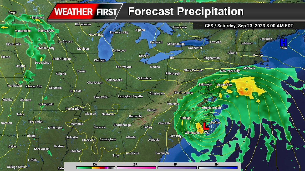
A developing offshore storm system expected to impact the Mid-Atlantic this Saturday is showing signs of shifting farther east, a trend that could significantly reduce rainfall chances for inland areas of the Delmarva Peninsula.
Latest model guidance from the 00Z cycle indicates a subtle but important eastward adjustment in the track of the coastal low. If this trend holds, the bulk of the precipitation shield would remain offshore, with only coastal counties seeing measurable rainfall. Areas farther inland, including much of central and western Delmarva, may end up largely dry.
Despite this shift, forecast confidence remains somewhat limited given that this is a relatively recent trend in the guidance. Current forecasts still maintain at least a chance of showers extending as far west as the I-95 corridor, reflecting a blend of solutions that have not fully locked in on the more offshore track.
In addition to reduced rain chances inland, this eastward shift has implications for wind impacts as well. With the strongest pressure gradient now expected to remain offshore, wind speeds across Delmarva on Saturday may be lighter than previously anticipated. Earlier projections suggested a breezier day, but current trends point toward more modest wind conditions, especially away from the immediate coastline.
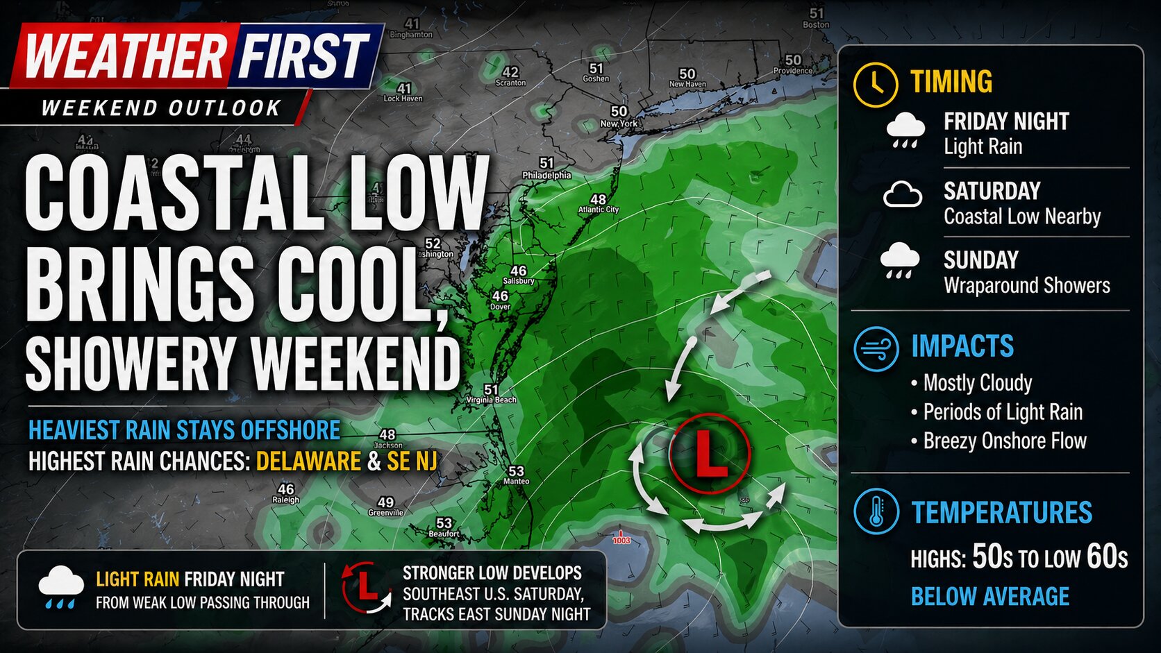
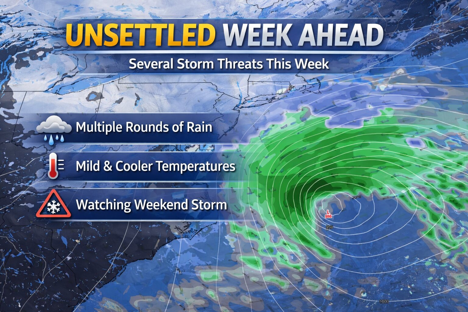
A pair of low pressure systems will impact the Delmarva region from Friday night through the weekend, bringing periods of light rain, gusty onshore flow, and a return to below-average temperatures.
The first system, a weak area of low pressure, is expected to pass through the region Friday night. This will deliver a quick shot of light precipitation, with most areas seeing minimal rainfall totals. Impacts from this initial system appear limited, but it sets the stage for a more complex setup heading into Saturday.
Attention then turns to a stronger system developing to the south. A deep upper-level trough digging across the Midwest and Gulf Coast states will help spawn a more organized area of low pressure over the southeastern United States. This system is forecast to lift north toward the Mid-Atlantic during the day Saturday before tracking offshore by Saturday night into Sunday.
For Delmarva, this track is critical. Current trends suggest the heaviest rainfall will remain offshore, particularly east of the coastline. However, wraparound moisture on the backside of the system will likely spread clouds and occasional rain back into the region, especially across Delaware and far southeastern New Jersey where rain chances are highest.
While this will not be a washout for most, periods of light rain and persistent cloud cover are expected through at least part of the weekend. The combination of onshore flow and thick cloud cover will also keep temperatures suppressed, with highs generally stuck in the 50s to low 60s, well below late-April normals.
Overall, the weekend will feature more clouds than sun, with occasional showers and a cool, damp feel. While beneficial rainfall is possible in spots, the bulk of the system’s moisture is expected to remain just offshore, limiting more widespread or heavier totals across the region.
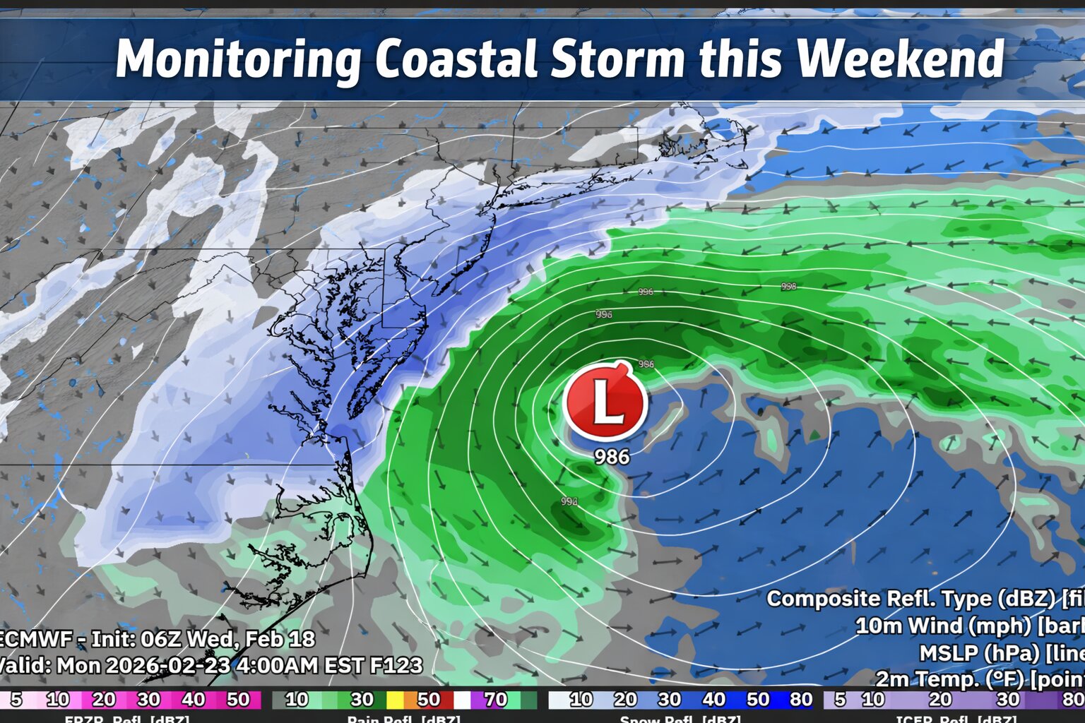
An active weather pattern continues across the Mid-Atlantic, and are now monitoring the potential for a coastal storm to impact the Delmarva Peninsula during the second half of the weekend.
While details remain uncertain, confidence is increasing that a developing area of low pressure will track west to east across the region late Sunday before strengthening offshore along the northern Mid-Atlantic coast. But there is also key details I’m not very fond of trusting.
Storm Track Will Determine Impacts
Most computer models show a storm developing and passing near the region Sunday. However, the exact track and strength of the surface low will ultimately determine how impactful this system becomes for Delmarva.
Recent trends in both deterministic and ensemble guidance have nudged the system slightly farther south and east. That shift could reduce overall impacts totals locally if it continues. Still, there remains a signal for a widespread precipitation event across the peninsula.
If the storm tracks close enough to the coast, stronger dynamics could enhance precipitation rates. At this stage, it is too early to determine rain and even snowfall amounts or pinpoint exact impacts.
Cold Air Will Be Key
The amount of cold air in place ahead of and during the storm will play a major role in determining precipitation type and accumulation potential.
Forecast guidance suggests that sufficient cold air may be present for accumulating snow across Delmarva if the storm tracks favorably. However, small shifts in the storm’s path could significantly change the outcome.
Relying On a Norlun Trough & Dynamic Cooling Never Fair Well For Delmarva
A Norlun trough is a narrow, elongated area of low pressure that can develop between two larger weather systems, often in New England or the northern Mid-Atlantic.
These features often form in cold, unstable air behind a departing coastal storm or between competing pressure systems. They can be difficult to forecast because they are small-scale and highly sensitive to subtle atmospheric changes.
On Delmarva, Norlun troughs are less common than in New England, but similar narrow deformation bands can produce comparable localized snowfall.
Dynamic cooling refers to a process where strong upward motion in the atmosphere causes temperatures to cool rapidly, sometimes enough to change rain to snow.
If precipitation falls heavily enough, it can also contribute to cooling through melting and evaporation, reinforcing the transition to snow.
Much Colder Air Early Next Week
Behind the potential weekend storm, a notably colder air mass is expected to settle into the region early next week.
High temperatures Monday and Tuesday may struggle to climb out of the 30s across Delmarva, with overnight lows dropping into the teens in many locations. The colder conditions could lead to icy spots lingering if snowfall occurs over the weekend.
An unsettled weather pattern is setting up across the Mid-Atlantic this week, bringing several opportunities for rain to the Delmarva Peninsula through the weekend. While areas to our north may deal with some wintry precipitation at times, the setup locally favors mainly rain events for Delaware and Maryland’s Eastern Shore.
Wednesday: Light Rain, Mainly North
The first system arrives Wednesday into Wednesday night as a warm front lifts northward ahead of low pressure tracking through the Midwest.
For Delmarva, this looks to be a primarily light rain event. Current trends show the steadiest rainfall staying north of our area, with southern Delaware potentially seeing little to no measurable rain. Most locations across Delmarva should see under a tenth of an inch, though a few spots could pick up slightly more if the rain shield trends farther south.
Overall, this is not expected to be a high-impact system. However, any rainfall will be beneficial as parts of the region continue to deal with ongoing drought conditions.
Thursday: Cooler With Spotty Showers Possible
Behind Wednesday’s warm front, a backdoor cold front may slide southward late Wednesday into Thursday. This front will usher in a cooler maritime air mass from the north or northeast.
If the boundary settles close enough to Delmarva, some areas could see patchy drizzle or light showers Thursday. Confidence in exact placement remains moderate, so coverage and amounts look limited at this time.
Friday Into Saturday: Another Round of Rain
Another low pressure system is expected to move in late Friday into Saturday. As of now, this system also appears to favor rain for Delmarva.
While slightly cooler air will be in place compared to midweek, temperatures across the peninsula are expected to remain warm enough to support mostly liquid precipitation. At this time, wintry precipitation concerns remain confined well to our north and do not appear to be a factor locally.
Rainfall amounts will depend on the eventual track and timing of the system, but there is at least some potential for moderate rainfall if the storm strengthens or slows.
Late Weekend: Watching a Potentially Stronger Storm
Attention then turns to another possible system toward the end of the weekend. Of all the upcoming disturbances, this one carries the greatest uncertainty and the widest range of possible outcomes.
Forecast guidance shows everything from a storm tracking well offshore with minimal impact, to a more organized system bringing steadier precipitation to the region. It is still too early to determine specifics, including rainfall amounts or any other impacts.
At this point, the late weekend system remains in the monitoring phase, and forecast details will likely evolve over the coming days. But with the way weather models have been handling the last several storm systems, it’s hard to put faith in one single solution.
After a prolonged stretch of cold and limited rainfall, a much more unsettled weather pattern is taking shape across the Delmarva Peninsula this week. Several low pressure systems are expected to move through the Mid-Atlantic, bringing multiple opportunities for measurable rain through the weekend.
First Round: Wednesday into Wednesday Night
The first system arrives Wednesday afternoon into Wednesday night as a warm front lifts northward ahead of low pressure tracking through the Midwest.
For Delmarva, this system is expected to bring mainly light rain, with recent model trends pointing toward an all-rain event. Rainfall amounts look modest overall, with:
Low probability of totals exceeding 1 inch
Most locations likely seeing light to moderate rainfall
Rain chances highest Wednesday afternoon and evening
While rainfall amounts do not appear heavy, this system could deliver the first measurable rainfall in several weeks for parts of the region, as recent precipitation events have largely fallen as snow due to persistent cold temperatures.
Thursday: Spotty Showers Possible
Delmarva remains in the warmer sector of the system Thursday into Thursday night. That means temperatures stay milder, and while widespread rain is not expected, isolated showers may pass through at times.
Second System: Friday into Saturday
Another low pressure system moves toward the region late Friday into Saturday. Much like the midweek system, this one also appears to favor primarily rain across Delmarva.
Current projections suggest:
Rain likely late Friday into early Saturday
Lower probabilities of heavy rainfall
No significant winter weather concerns for the Peninsula
At this time, forecast guidance does not indicate any moderate or major impacts from this system.
Watching the Weekend
Looking ahead to late weekend, there are signals of yet another potential system. However, forecast models vary significantly on its strength and track. It is too early to determine specific impacts or precipitation types, but it is something forecasters will continue monitoring.
Overall Impact for Delmarva
For the Delmarva Peninsula, this upcoming pattern looks to bring beneficial rainfall rather than disruptive weather. After weeks of colder conditions and limited liquid precipitation, this stretch of rain could help recharge soils and provide needed moisture without significant flooding concerns.
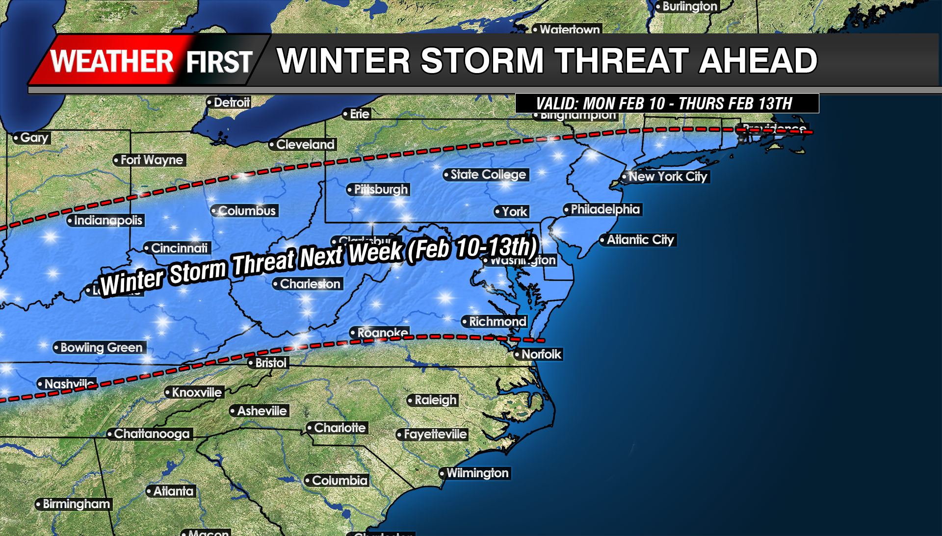
We are gearing up to be in a fairly hostile pattern with many pieces of energy to play with here over the next 2 weeks as a large long wave trough sits over the eastern US. The biggest issue right now is do they interact with each other or will they remain strung out wasting the potential for snow lovers out there.
While the overall risk of impactful wintry weather remains low heading into early next week, colder temperatures mean even small changes in the forecast could introduce a chance for snow.
A brief warm up to near seasonal levels is expected Saturday ahead of a passing cold front. Behind it, a colder pattern looks likely to settle back in and persist through at least the middle of next week, with temperatures running below normal. During this time, several weak disturbances are forecast to move through the region. While none of these systems appear particularly strong on their own, there is a possibility they could interact in a way that brings a wintry weather threat late Sunday into Monday.
ECMWF Model OutputECMWF-AIFS Model OutputCMC Model OutpuutGFS Model Output
At this time, the most likely outcome would be flurries or light snow, with limited or no accumulation. However, if the shortwave has more of a interaction with the Jetstream, that can bring larger impacts. Forecast confidence remains low, with precipitation chances generally in the 20 to 30 percent range.
Given the cold air in place, this period will need to be monitored closely for any changes that could increase the wintry weather threat. For now, the risk of a significant winter storm from Sunday into early next week remains low, but not zero.
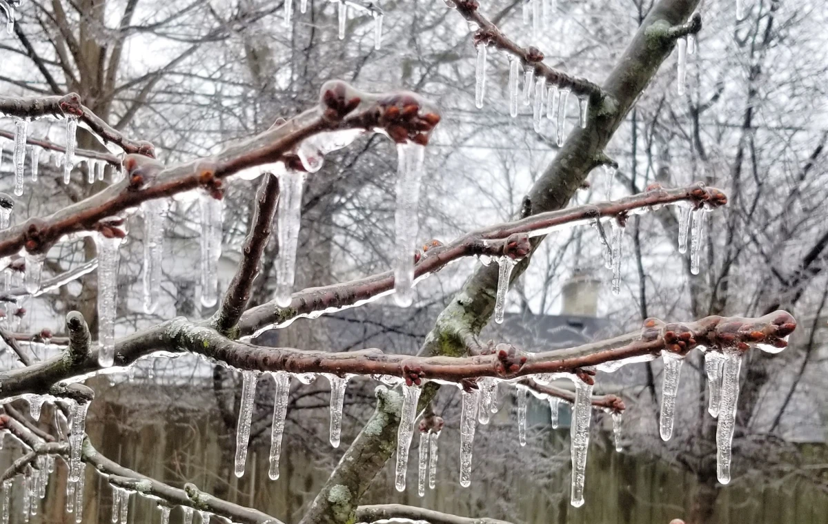
A rapidly moving arctic cold front will create dangerous flash freezing conditions early Thursday morning, posing a significant hazard for travel across the region.
Temperatures are expected to fall sharply from the 50s into the 20s in just a few hours as the front passes. Rain will transition to snow during this time, but the most serious concern will be the sudden freeze of wet roadways, sidewalks, and bridges.
As colder air rushes in behind the front, any standing water from earlier rainfall will freeze almost instantly. This can lead to a thin but extremely slippery layer of ice forming with little to no warning. Bridges, overpasses, untreated roads, and shaded areas will be especially vulnerable to rapid icing.
The timing of the temperature drop may coincide with the Thursday morning commute, increasing the risk for accidents and hazardous travel conditions. Even areas that see minimal snowfall could experience dangerous conditions due to ice forming faster than road crews can treat surfaces.
Gusty winds behind the front will reinforce the cold air and cause wind chills to drop quickly, making conditions feel even colder by daybreak. Any snow that does fall will be brief, but it may further reduce visibility during the transition.
Residents are urged to use caution if traveling early Thursday morning. Slowing down, allowing extra stopping distance, and remaining alert for icy patches will be critical. If possible, delaying travel until conditions improve later in the morning is strongly advised.
Conditions are expected to stabilize later Thursday as precipitation ends, but cold temperatures will persist through the day.
A developing storm system will bring a brief period of light rain to Delmarva late Wednesday, with the potential for a few snowflakes before the precipitation ends early Thursday. While impacts from precipitation look minimal, the bigger story will be the sharp drop in temperatures and strong winds that follow and last into Friday.
On Wednesday, a cold front associated with a passing system to our north will move through the region. This front will help produce a shield of light precipitation across the area Wednesday afternoon and evening. With temperatures starting off mild, most locations on Delmarva will see rain initially. As colder air moves in overnight, rain could briefly mix with or change to snow before ending early Thursday morning. Any snow accumulation is expected to be very light, with little to no impact expected across Delmarva.
A secondary storm system is expected to develop offshore along the Carolina coast late Wednesday night into Thursday. Current forecast guidance keeps this system well offshore, meaning it should have little to no effect on our region. Because of this, confidence remains high that Thursday will be largely dry, aside from a small chance of lingering light precipitation early in the morning.
Temperatures will be relatively mild ahead of the front on Wednesday, with highs ranging from the mid 40s to near 50 degrees across Delmarva. Conditions will change quickly Wednesday night as colder air pours into the region. By Thursday morning, temperatures will drop into the mid 20s to near 30 degrees. Strong west to northwest winds will develop, creating wind chills in the teens and lower 20s through much of the day.
Thursday will feel bitterly cold and blustery, with sustained winds of 15 to 25 mph and gusts occasionally reaching 30 to 35 mph. Afternoon temperatures will struggle to recover, only reaching the upper 20s to mid 30s despite some sunshine.
The coldest air arrives Thursday night into early Friday. Overnight lows will fall into the teens and lower 20s across Delmarva, and persistent winds will push wind chills into the single digits by Friday morning. Friday remains cold, with highs once again in the upper 20s to mid 30s and wind chills staying in the lower to mid 20s.
While this system will not bring significant precipitation, the combination of strong winds and sharply colder temperatures will make it feel more like mid winter across Delmarva heading into the end of the week.
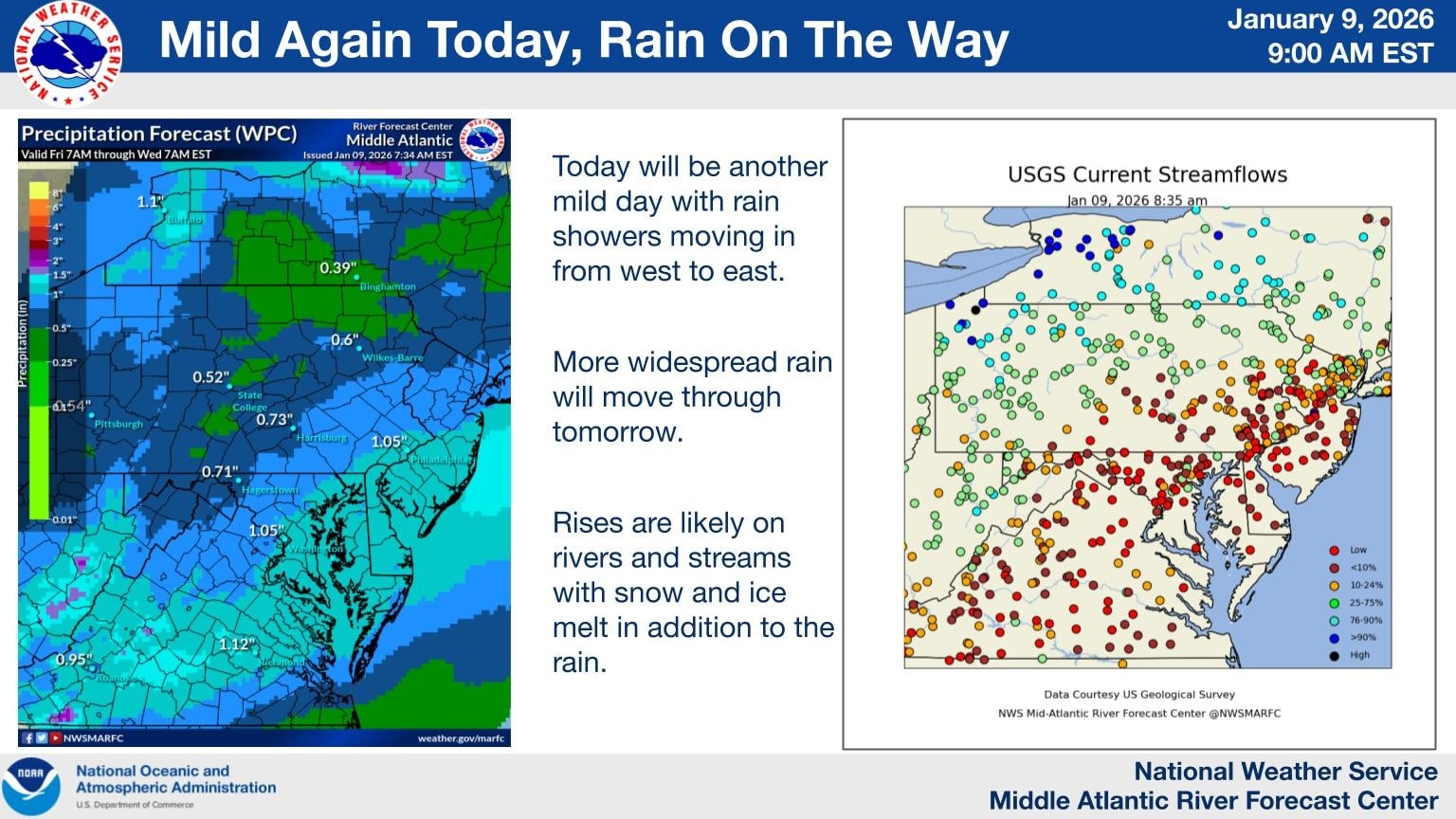
A prolonged period of unsettled weather is expected to impact much of the Mid Atlantic beginning later this evening and continuing through Sunday, bringing multiple rounds of rain and the potential for localized flooding concerns.
Rain showers will begin moving into the region from west to east this evening as a mild and moisture rich weather pattern remains in place. While rainfall tonight is expected to be generally light to moderate, coverage will increase overnight and into Saturday as a stronger system approaches.
More widespread rain is forecast for Saturday and Saturday night as deeper moisture moves into the Mid Atlantic. Periods of steady rain are likely, with occasional heavier downpours. Embedded isolated thunderstorms are also possible during this time, which could briefly enhance rainfall rates in some areas.
By Sunday, additional rounds of showers are expected to continue, keeping soils saturated and rivers on the rise. While rainfall amounts will vary by location, several areas could see one to two inches of rain by the end of the weekend, with locally higher totals where heavier showers or thunderstorms occur.
Delmarva Region Faces Elevated Rain And Water Concerns
Across the Delmarva Peninsula, including Delaware, eastern Maryland, and the Eastern Shore of Virginia, the rain threat will become more pronounced overnight and persist through the weekend. Rainfall totals of one to two inches are likely across much of the region, with isolated higher amounts possible.
The combination of steady rain, mild temperatures, and ongoing snow and ice melt farther north could lead to noticeable rises on rivers, streams, and creeks. Low lying and poor drainage areas may be especially susceptible to ponding of water, particularly during periods of heavier rain.
While widespread flooding is not currently expected, localized minor flooding cannot be ruled out, especially if thunderstorms produce brief heavy downpours. Urban areas and locations near small waterways should remain alert for changing conditions.
Residents across the Delmarva Peninsula should prepare for several rounds of rain as a series of weather systems move through the region from late Friday into early Sunday. While no significant flooding or severe weather is expected, the stretch will bring generally wet and mild conditions.
The first system arrives late Friday as a weakening cold front moves into the Mid-Atlantic. This front is tied to an area of low pressure lifting north from the Great Lakes toward Quebec. Rain is expected to develop Friday afternoon and continue into Friday night. As the front weakens and gradually dissipates over the region, temperatures are not expected to drop noticeably, with little to no cold air pushing in behind it.
A second, more impactful system follows on Saturday. A deepening upper-level trough moving south from Canada into the Great Lakes will help spawn a new surface low over the lower Mississippi River Valley. This low will track northeast, pushing a warm front northward across Delmarva on Saturday. As the warm front lifts through the region, rain coverage will increase and milder air will overspread the peninsula.
Temperatures on Saturday may behave unusually, with some locations seeing their highest readings later in the day or even during the evening hours as warmer air moves in. Overnight temperatures may hold steady or even rise slightly in some areas. Overall, Saturday is expected to be a warm and wet day, with temperatures ranging from the upper 40s to the low 60s.
Heavier rain is expected to move in later Saturday as an initial cold front crosses the region. While a brief rumble of thunder cannot be ruled out due to some elevated instability in the atmosphere, no severe weather is anticipated. Showers may linger Saturday night until a secondary cold front moves through on Sunday morning. Behind that front, winds will increase, but the chance of wind gusts reaching advisory levels remains low.
There is higher confidence that Delmarva will see periods of rain from Friday afternoon through Sunday morning, though exact rainfall totals remain uncertain. Most guidance suggests at least a half inch of rain, with some models indicating localized totals between 1.5 and 2 inches. The probability of receiving one inch or more of rain is around 40 to 60 percent, while the chance of exceeding two inches is low.
Rainfall is expected to fall over a 36 to 48 hour period with breaks between systems, reducing the risk of flooding. With mild temperatures in place leading into the weekend, any remaining ice in streams or rivers should have already melted, allowing water to drain efficiently. Confidence in rainfall totals and timing is expected to improve as the weekend approaches.
The Delmarva region is expected to see several rounds of rain as a series of weather systems move through the area from late Friday into Sunday morning. While the rain will be spread out over time, confidence is high that most locations will see wet conditions at some point during the weekend.
The first round of rain arrives late Friday into Friday night as a weakening cold front crosses the region. This front is associated with an area of low pressure moving from the Great Lakes toward eastern Canada. Because the front is weakening as it approaches Delmarva, it is not expected to bring much of a temperature drop or colder air. Rain during this period should generally be light to moderate.
A stronger system moves in on Saturday as a slow moving trough dives south from Canada into the Great Lakes. This will help develop a new area of low pressure over the Lower Mississippi Valley that tracks northeast toward the Mid Atlantic. A warm front is expected to lift through Delmarva Saturday morning, placing the region in a warmer and more humid air mass. Temperatures are forecast to rise into the 60s, which is mild for this time of year, though still a few degrees shy of daily records.
Heavier rain is expected later Saturday into Saturday night as a cold front moves through the region. There may be enough instability in the atmosphere for a rumble of thunder, but severe weather is not expected. After the initial front moves offshore Saturday night, scattered showers may linger until a secondary cold front passes through on Sunday morning.
Once the secondary front clears the area, winds will increase, but the chance of wind gusts reaching advisory levels remains low. Overall, rainfall will be spread out over a 36 to 48 hour period with breaks between rounds.
Forecast confidence is high that rain will occur, but exact rainfall totals remain uncertain. Most guidance suggests at least a half inch of rain, with some models indicating localized totals between 1.5 and 2 inches. The probability of receiving one inch or more of rain sits around 30 to 50 percent, while the chance of exceeding two inches is low.
Despite the potential for moderate rainfall, flooding concerns remain minimal. The rain will fall gradually rather than all at once, and recent mild temperatures should have eliminated any lingering ice in creeks or rivers, allowing water to drain efficiently.
More confidence in rainfall totals is expected as the weekend approaches, but residents across Delmarva should be prepared for several periods of rain from Friday afternoon through Sunday morning.
As the temperatures begin to warm up, so does the rain chances as we approach the weekend ahead. Rain will begin to move into the Delmarva region during the morning hours on Friday as a warm front lifts towards New England. Rain chances continue all the way through early Sunday morning when the cold front swings through. But will this bring any relief to the drought situation here in the Mid-Atlantic?
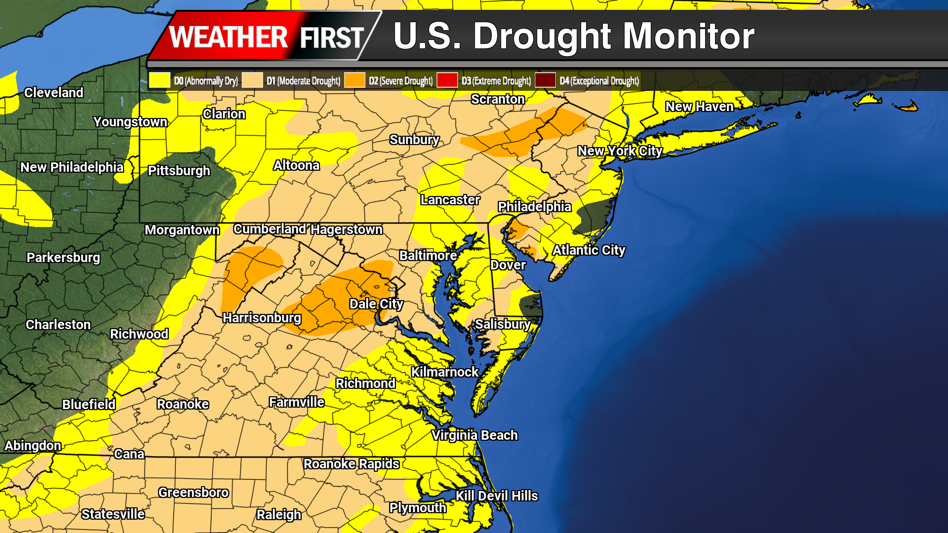
Much of the Mid-Atlantic remains under ongoing drought conditions as of early January. Abnormally dry conditions continue across large portions of Maryland, Delaware, southern Pennsylvania, and northern Virginia, with moderate drought expanding across central and western Maryland into parts of northern Virginia. The most pronounced dryness is focused west of the Chesapeake Bay, including areas near Washington, Frederick, and Hagerstown, where prolonged precipitation deficits persist. While coastal sections of the Delmarva Peninsula remain primarily abnormally dry, limited improvement has occurred, and soil moisture remains below normal. These conditions continue to stress agriculture, water resources, and increase the risk of winter wildfire activity if dry weather persists.
Heavier rainfall potential this weekend is focused farther north and west, with higher totals indicated across parts of western and central Pennsylvania and into the higher terrain of western Maryland. Lighter precipitation amounts are expected south and east, including much of central and southern Virginia and portions of the Delmarva Peninsula, where totals look more modest. This setup suggests the best chance for more meaningful rainfall will be away from the coastal plain, while areas closer to the Chesapeake Bay and southward may see limited rainfall and little improvement to ongoing dry conditions.
Dry weather has continued to dominate the Delmarva Peninsula, with the latest drought data showing little improvement and increasing stress across the region. While occasional light rainfall has been observed, precipitation totals remain well below normal, providing minimal benefit to soil moisture, groundwater, or streamflows.
Across Delaware, Maryland’s Eastern Shore, and Virginia’s Eastern Shore, ongoing precipitation deficits have allowed abnormally dry to drought conditions to persist and expand. Soils continue to dry, particularly in agricultural areas, and streamflows remain below seasonal averages; clear indicators that the region remains in a developing drought pattern.
In Delaware, short-term dryness is increasingly transitioning into longer-term impacts, with limited recharge of groundwater and growing concerns for water resources if the dry trend continues. On the Maryland Eastern Shore, reduced soil moisture is beginning to affect winter crop establishment and could pose challenges heading into the early spring growing season if meaningful rainfall does not return. Portions of the Virginia Eastern Shore are experiencing similar conditions, with continued low streamflows and dry soils reinforcing drought development.
Looking ahead, forecasters stress that several widespread, soaking rain events will be necessary to slow or reverse drought conditions across Delmarva. Until a wetter pattern develops, drought impacts are expected to persist through the remainder of the year, with close monitoring in place for further degradation.
An active weather pattern is set to affect much of the United States late next week and into the weekend, with strong weather systems expected to bring heavy precipitation, high winds, and potential drought conditions to various regions.
The National Weather Service forecasts a strong surface low moving across the country, particularly impacting the central and eastern U.S. This will likely bring periods of heavy rainfall and high winds, while the Southern Plains may experience below-average precipitation and rapid onset drought conditions.
Heavy Precipitation and High Winds Expected
From late next week through the weekend, the East Coast will face a high risk (over 60% chance) of heavy precipitation. A broader moderate risk (40-60% chance) extends across much of the eastern U.S., with areas experiencing saturated soils potentially at risk for flooding. In the Northern and Central Plains, Upper Mississippi Valley, and Western Great Lakes, moderate snow accumulation is anticipated, along with high winds in many central U.S. states.
The combination of snow and wind could cause disruptions to transportation networks, power outages, and tree damage. Meanwhile, regions across eastern New Mexico, western Texas, and southwestern Oklahoma are facing the threat of rapid drought development.
Dry Conditions in the Southern Plains
While much of the U.S. is set to see above-normal precipitation, parts of Texas and southwestern Oklahoma are forecast to experience below-average rainfall, which could intensify drought conditions. The persistent dry conditions and strong winds could increase the risk of significant wildfires in the area.
Potential Impacts and Hazards
The forecasted heavy precipitation could lead to flooding in areas still recovering from the aftermath of Hurricane Helene, particularly along the East Coast. As the storm system moves across the country, high winds may bring additional challenges, from power disruptions to transportation delays. The ongoing dry conditions in the Southern Plains also raise concerns about rapidly worsening drought and wildfire risks.
As this active weather pattern unfolds, residents are encouraged to stay informed and prepare for potential disruptions.
If you were hoping to have a nice weekend ahead with good weather, this is not the weekend for it. Although the rain is welcomed and very beneficial for the ongoing extreme drought we are in, makes for plans to be remaining indoors. Rain will begin to move into the region during the afternoon hours on Saturday as a warm front lifts through. Rain will be heavy at times after dark through the morning hours.
There will be a lull in the precipitation heading into the later morning hours on Sunday but we will see a noticeable increase in temperatures surging into the mid 60s. A cold front will be arriving later in the after hours bringing back the heavy rainfall and maybe even a few gusty thunderstorms are possible.
The Storm Prediction center already highlighting a “Marginal” risk of severe weather for the afternoon hours on Sunday as a potential thing line of storms may form along the cold front. Although not expecting widespread thunderstorm development, a few rogue storms are not out of the question.
Rainfall on the order of 1-2 inches is very plausible before tapering off Sunday night across the region. Might be some low lying area flooding with the recent rainfall events and the major snow melt from a few days ago.
Another winter storm is set to impact the region as we move into Tuesday and Wednesday, bringing a mix of heavy snow, ice, and rain across the Delmarva Peninsula. Snow and wintry precipitation will begin Tuesday afternoon and continue through Wednesday morning, leading to widespread travel disruptions and hazardous conditions.
This storm is developing as a new area of low pressure forms over the Deep South and tracks northeastward along a stalled frontal boundary. At the same time, a strong high-pressure system to the north will funnel cold air into the region, setting the stage for a classic overrunning event. In this setup, warm, moisture-laden air from the Gulf of Mexico moves over the dense, cold Arctic air advancing southward from Canada, creating widespread heavy snowfall from the Midwest into the Mid-Atlantic. This process, known in meteorology as isentropic ascent, drives the formation of clouds and precipitation as the warm air rises and cools.
In a winter storm overrunning setup, isentropic ascent occurs when warm, moist air is forced to rise over a cold, dense air mass at the surface. This typically happens along a stationary front or warm front, where the warm air follows sloping isentropic surfaces (constant potential temperature). As the air rises, it cools adiabatically, leading to cloud formation and precipitation.
Since winter storms involve subfreezing surface temperatures, this precipitation can fall as snow, sleet, or freezing rain, depending on the temperature profile. Stronger isentropic ascent enhances moisture transport and lift, leading to heavier and more widespread winter precipitation.
Snowfall Potential and Accumulation Estimates
The latest ensemble model guidance indicates a significant increase in snowfall probabilities across central and northern Delmarva. There is now a 60-90% chance of at least 3 inches of snow north of the Maryland-Delaware state line, with 40-60% probabilities for accumulations exceeding 6 inches from Delmar, DE to Smyrna, DE.
The heaviest snowfall totals are expected between the MD/DE line and Smyrna, where an average of 4 to 8 inches is forecast. This extends westward toward Washington, D.C.. However, localized snow bands could produce isolated totals up to 10 inches, particularly across central Delmarva.
Coastal and Southern Delmarva Impacts
Further south, near the coastal areas including Berlin and Pocomoke City, the storm will begin as snow but may transition to a mix of snow, sleet, and rain as temperatures rise above freezing. This will reduce overall snowfall totals due to melting overnight Tuesday into early Wednesday.
Meanwhile, areas further north will remain all snow, though the intensity may be slightly lower compared to central Delmarva. Regardless, this storm is shaping up to be a significant winter weather event across the region, bringing hazardous travel conditions and potential disruptions.
Stay tuned for updates as forecast details continue to evolve.
A complex winter weather system is set to impact portions of central and northern Delmarva, bringing a mix of snow, sleet, and freezing rain as temperatures hover near the freezing mark towards early Saturday afternoon. This system will create hazardous travel conditions, especially in areas where freezing rain leads to ice accretion.
Weather Setup and Model Guidance
Latest guidance from the ICON, GFS, and ECMWF suggests that cold air at the surface will remain entrenched across northern Delmarva, allowing for a prolonged period of wintry precipitation before a gradual changeover to rain. Meanwhile, high-resolution CAMS guidance, including the HRW-WRF & NAM12KM, continues to highlight higherlocalized areas of ice accumulation, particularly in northern regions where cold air remains stubborn.
As the system moves through, precipitation is expected to start as a wintry mix of snow, sleet, and freezing rain across northern and central Delmarva, with surface temperatures struggling to rise above 32°F. By early afternoon, warmer air aloft will cause much of central Delmarva to transition to plain rain, while northern Delmarva may see continued ice accretion before the system exits early Sunday.
Potential Ice Accretion and Travel Hazards
Ice Accumulation: Up to 0.10” of ice is possible across northern & central Delmarva, with localized higher amounts in areas where freezing rain persists.
Travel Impacts: Slick roadways and hazardous conditions are expected, particularly on bridges and overpasses. Untreated surfaces may become icy and dangerous.
Timing: The wintry mix will continue through early afternoon, with a gradual transition to rain in central Delmarva through the evening hours. Northern areas may hold onto freezing rain longer before precipitation moves out early Sunday morning.
Stay Weather Aware
Residents across central and northern Delmarva should stay updated with the latest forecasts, as even small changes in temperature could impact precipitation type and ice accumulation. If traveling, exercise caution and allow extra time, especially in areas where freezing rain may linger.
Just when it seemed like winter might be winding down, another round of winter weather is on the horizon. After a brief break from bitter cold and snow, forecast models indicate that winter storm threats will return next week, affecting the Midwest, Mid-Atlantic, and Northeast. This won’t be just one isolated storm, but several waves of wintry weather are expected. This setup is similar to the major winter storm we experienced in early January, featuring a classic “overrunning” pattern, which often produces significant snowfall in our region. But what exactly is an overrunning winter storm?
An overrunning winter storm occurs when warm, moisture-laden air moves over a colder, denser air mass at the surface, leading to prolonged periods of wintry precipitation. This happens when warm air from the south collides with cold air entrenched to the north. Unlike last time, however, this system is being driven by a strong Arctic high-pressure system, rather than a blocking low-pressure system to the north. Scientifically, this process is known as Isentropic Ascent—a term used to describe how air is lifted along a temperature gradient.
ICON Model OutputECMWF Model OutputUKMET Model OutputCMC Model Output
Current mid-range model guidance (GFS, ECMWF, UKMET, CMC, ICON) consistently shows an overrunning event with multiple waves of low pressure traveling along a stalled frontal boundary. A strong high-pressure system (1038-1040mb) will provide ample cold air north of this boundary, while incoming warm, moist air will fuel heavy precipitation. The exact position of the frontal boundary will determine whether areas experience heavy snow, plain rain, or, in the worst-case scenario, significant icing. Overrunning setups are notorious for producing dangerous ice storms, as cold air remains locked at the surface while warm air aloft causes precipitation to fall as freezing rain or sleet—leading to hazardous road conditions.
WSSI-P “Minor” Impacts ProbabilityWSSI-P “Moderate” Impacts Probability
The Weather Prediction Center (WPC) has already issued impact probabilities for next week’s potential winter storm, indicating a 50-60% chance of Minor Winter Storm Impacts and a 40-60% chance of Moderate Winter Storm Impacts. This suggests that disruptions to travel and infrastructure closures could occur.
We’ll continue to monitor the latest forecast developments and provide real-time updates as this potential winter storm approaches early next week. Stay tuned for the latest information.
A much-needed round of rainfall is set to arrive across the Delmarva Peninsula late tonight, providing a temporary break from the dry conditions that have persisted for months. A warm front will lift through the region after midnight, bringing light to moderate rain that will continue through much of Friday. While occasional breaks in the precipitation are possible, Friday is expected to be a generally wet day before rain tapers off just before sunrise on Saturday morning.
Rainfall totals will range between 0.5 to 1 inch on average, with localized areas potentially receiving slightly higher amounts. While this rain will help to wash away accumulated road salt and provide some short-term relief, it will do little to alleviate the severe to extreme drought conditions gripping the region. Rainfall deficits remain substantial, with much of Delmarva running nearly a foot below average for the past several months. This system, though beneficial, will barely make a dent in the long-term precipitation shortfall.
Nonetheless, the rain will bring some temporary improvements to soil moisture levels and reduce the immediate fire danger that has accompanied the prolonged dry spell. However, with no significant additional rainfall in the extended forecast, drought conditions are likely to persist into February.
More rain is in the forecast as we approach the weekend, but unfortunately, it is unlikely to significantly alleviate the ongoing drought conditions. Although several snowfall events have occurred this winter—including the major storm on January 5-6—these have not contributed meaningfully to overall precipitation levels. The region remains in a notable deficit, and the upcoming weather system is expected to provide limited relief.
Later this week, a storm system originating from the Deep South will begin impacting the area. A warm front will approach Friday morning, bringing intermittent light rain throughout the day. This pattern of precipitation will persist into early Sunday morning. Current projections estimate rainfall amounts between 0.50 and 1 inch; however, these figures are subject to change as the system develops. Unfortunately, even this level of precipitation will be insufficient to make a significant dent in the drought conditions.
Current Precipitation Deficit
We extend our gratitude to National Weather Service Meteorologist Michael Lee from Mount Holly for providing valuable data and graphical insights into the current precipitation shortfall.
Georgetown, DE: From January 28, 2024, to January 27, 2025, the normal precipitation should be 43.98 inches. However, the actual precipitation recorded so far is only 31.66 inches, resulting in a deficit of 12.32 inches.
Wilmington, DE: During the same period, normal precipitation is expected to be 45.43 inches, but only 38.37 inches have been recorded, creating a deficit of 7.06 inches.
These figures highlight the severity of the situation, emphasizing the significant gap that remains to be addressed in the coming months.
Impacts on Agriculture
The continued drought is a major concern for local farmers, particularly with the spring growing season fast approaching. Persistent dry conditions are likely to place extreme stress on agricultural operations, potentially affecting crop yields and overall productivity. Addressing this deficit before spring is critical to reducing the strain on farmers who have already faced significant challenges due to drought conditions in recent years.
While the upcoming rainfall is welcome, it is clear that much more precipitation will be needed to recover from this prolonged dry spell. The hope remains that weather patterns in the next few months will bring sustained rainfall to help close the gap and alleviate some of the burdens facing the region.
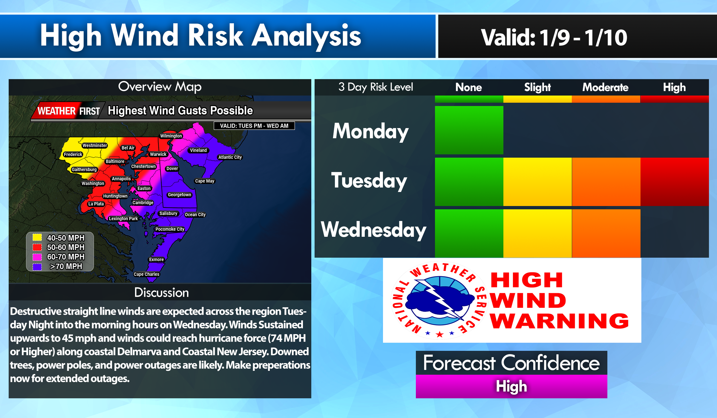
Buckle up ladies and gentleman, tomorrow is going to be a very bumpy ride for us. Flooding rainfall, significant coastal flooding, and a serious high wind threat. And all of this begins during the afternoon hours Tuesday.
Now we have been dealing with flooding since last month but what has me the most concerned is the absurd strength of these winds moving in tomorrow. A intense pressure gradient from a rapidly deepening surface low and strong high pressure system will generate a scenario of very intense winds. Strengthening of the low level winds in the low level jet-stream is some of the strongest I have seen for this region. Winds at 850-925mb level (<5000ft) screaming at 80-100 kts (92-115mph) is on the extreme end of likes I have not seen before. Now granted as we head down to the surface we are looking at reductions due to mixing but these winds are going to be fierce and nothing to play around with. My biggest concerns are for the southern and central portions of Delmarva where I believe we have a great shot of hitting hurricane force winds gusts at or exceeding 74 mph where the High Wind products are in place. Many locations will be seeing winds gusting 60 mph or greater at times. Power outages, downed trees, structural damage are all possible with these kinds of winds.
Of course more flooding concerns for the region with the extremely saturated grounds from last months dump of 10-12 inches of rainfall. Another 2-4 inches are possible prompting a MDT risk from the WPC on excessive rainfall through the western shore of Maryland and northern Delmarva. Flood watches are in place in response to the heavy amounts of rainfall.
Moderate to Major Flood Stage is expected across the Chesapeake Bay and the mouth of the Delaware Bay with the upcoming high cycles Tuesday Night and Wednesday. Some of which forecasts at certain tidal gauges could hit record levels! Atlantic coastal regions even though will have extremely large swell, winds will be parallel to the coast to keep tide levels down but will be funneling in significantly through the Chesapeake and Delaware Bay regions. Those who live near these water ways, make preparations to evacuate or seek higher ground if flood waters becoming inundating in your areas. Also make preparations to help protect your property from flood waters.
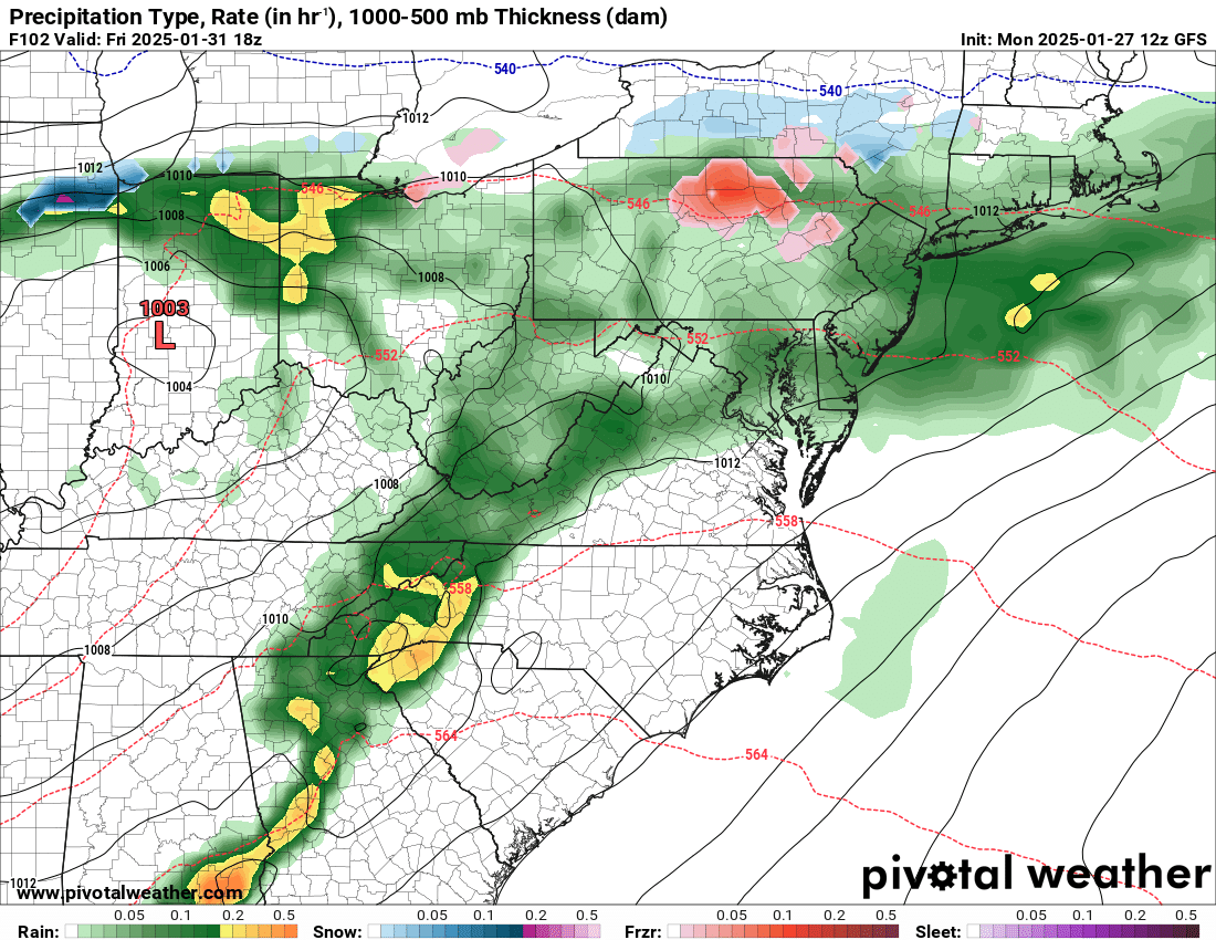
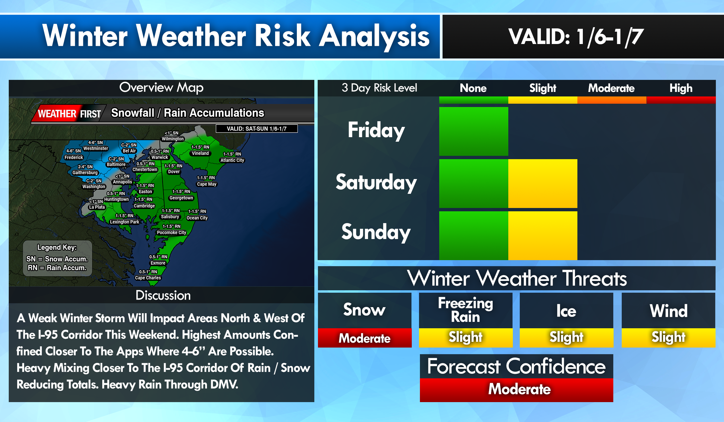
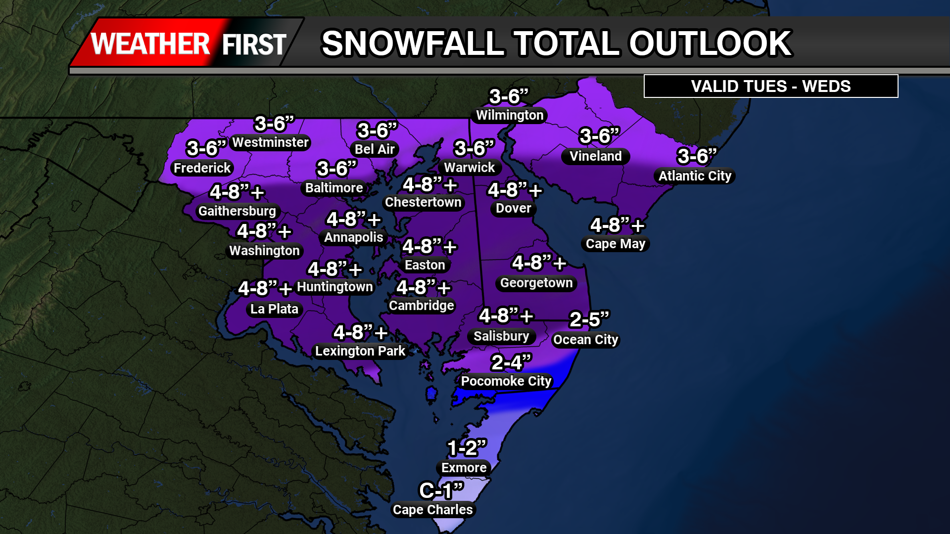
*** FIRST CALL SNOWFALL / RAINFALL OUTLOOK FOR SAT-SUN ***
Been quite some time I’ve had to dust off this map but here we go ladies and gentlemen. North and West of the I-95 Corridor are in the zone for looking at some accumulating snow for this upcoming weekend. Mainly closer to the mountain ranges of the Appalachians. A range of 4 to up to 6 inches are possible through Frederick, Md and Westminster, MD. Mixing is also possible in those areas with temperatures hovering near 32 degrees which can shave some totals off slightly.
Closer to I-95 will be dealing with snow starting off and mixing with rain and ice before changing to all rain towards the overnight hours Saturday. Greatly reducing snowfall totals for them. Extreme northern areas of Delmarva can see up to an inch of snow before melting and changing to all rain.
Those across Central Delmarva, more unneeded rainfall is coming which could lead to some spotty areas of low lying flooding with 1 to 1.5 inches of rainfall.
Winds will not be very bad with this storm but could gust 40-45 MPH along the coastal communities with areas of minor coastal flooding.
This storm will only be a minor inconvenience before the bigger problem arises towards next week with significantly more amounts of rain and higher confidence of a damaging High Wind Event.
A big tone shift with the overnight model runs shows full speed ahead of a tropical system moving in from the Carolinas up into the Chesapeake Bay region. Which is the worst case scenario for any track of a storm system here on the shore.
Many of the high resolution model guidance showing heavy rain beginning to move in starting in the evening hours on Friday from south to north as the winds start to increase from the east. Winds could be gusting as high as 50 mph along the coastlines with 40-50 for the inland locations. Along with the major waves coming ashore of 10-20 feet. Combination of a high tide cycle, heavy rainfall, strong long fetched onshore winds, coastal flooding is going to be a big problem.
Early indications from a few days ago had flooding in the minor to borderline moderate levels. Well with high confidence now with the storm track and overall strength, moderate to potential major levels of coastal flooding exist for all water ways along the Atlantic, Delaware Bay, and of course the inland bays in Sussex, Kent and Worcester counties. Inundation of 1-3 feet are on the table on Saturday.
Rainfall with tropical moisture is surely going to be a issue for areas along coastal Delaware down the Bay Bridge Tunnel. across the mid-shore we will average of 2 to 5 inches of rain. Highest for those farthest south and east.
Now my least favorite topic, tornadoes. If we do have a tropical system on our hands rather than a hybrid or extra tropical cyclone, being on the right side of it is never a good thing. Slight curvature in the hodographs suggest we do have some turning in the atmosphere. Whether we have the little bit of instability remains to be in question. Tornadoes are a possibility but not with very high confidence right now.
Prepare for a potentially major storm system heading into this weekend.
Confidence continues to increase for some sort of sub-tropical in nature storm system to develop along a stalled out frontal boundary off the coast of Florida and Georgia. With a strong area of high pressure it place towards New England, this will allow this system to intensify and move in towards the Carolina coastlines late Friday through Sunday.
Overspreading heavy rain, gusty winds, and coastal flooding are all expected this weekend. Especially on Saturday when the conditions are expected to be the worst out of this storm. Whether this storm will be tropical in nature or not, impacts are going to be felt like a stronger nor’easter we would see in the winter months.
Rain will begin to overspread the region beginning during the overnight hours on Friday and picking up in intensity on Saturday. Rain will be heavy at times with many operational and ensemble mean totals of 2-5 inches are expected over the weekend. With an area of high pressure to north, a strong pressure gradient will setup with constant strong onshore winds from the east and northeast. Sustained winds of 20-30 MPH with gusts 40-50 mph at times, will help generate waves offshore 10-20 feet. Near the coast, we are looking at swells generating 7-12 feet.
With some of the the tide gauge forecasts as of now showing areas along the Atlantic Ocean and Inland Bay regions for Minor to even Moderate coastal flooding during the high tide cycle Saturday afternoon. I worry for the Inland Bays a lot more with all the water being forced with no where to go given how big the swells will be with the strong long fetched onshore winds.
It’s pretty definitive at this point that we have a coastal storm on the way, it’s just a matter of how much rain will be associated with this system, and if it happens to be tropical or not. Or even a combination of both being a hybrid sub-tropical system. More details will be provided as the week goes on.
With the potential hybrid storm coming this weekend, not only heavy rain and gusty onshore winds are a problem, these are going to be some big waves. Moderate coastal flooding is on the table for Saturday. With onshore winds of 40-50 mph wind gusts generating waves 10-20 feet offshore. That’s going to be driving water hard to the coastal locations. Inland bays will be the bigger issues where water will not have any place to go.
We still have days to go to see the full extent of details but the consistency in model guidance is very good with this one so far. Whether this will be a tropical system or a nor’easter, this will be bringing heavy rains, gusty winds, and coastal flooding.
High Res Window Model Showing Major Coastal Low Over Delmarva
We have been talking about this scenario throughout the week about a major storm system will be developing in the Eastern half of the nation. An area of low pressure will be rapidly developing from the Gulf States and runs parallel through the Mid-Atlantic states during the morning hours on Saturday.
Large Trough In the Eastern US
Phasing of the Northern Jet and the Sub-Tropical Jet will set the stages of a potential Bomb Cyclone (air pressure that drops more than 24mb’s in 24 hours) to develop. By the time this storm system moves north of New England we could be looking at some serious low pressures by Greenland.
Low Location Will Be Key
Depending on the placement of this area of low pressure will determine if we are in the path of the powerful low level Jetstream to setup. The blend solution has the area of low pressure going right over the Delmarva region keeping those powerful winds off of our coasts. But if the low positions further west, this will allow for a short term duration of strong winds exceeding 50 mph at times.
Low Level Jetstream 90-100kts offshore
To add more dynamics to the mix, cold air will be crashing on the northwest side of the storm which we may see a burst of snow on the backside during the evening hours. Any snow that does fall will have a extremely difficult time accumulating here on the shore. It’s a matter of how quickly can those temperatures crash on that backside of the storm. And the position of the low. If we have a further east solution like the NAM3km, then our chances are high but I have that one as my outlier as of now. I’m leaning more with the HRW-ARW with the further west solution overall.
Model Solutions Regarding The Backside Snow Threat
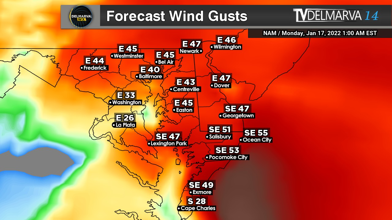
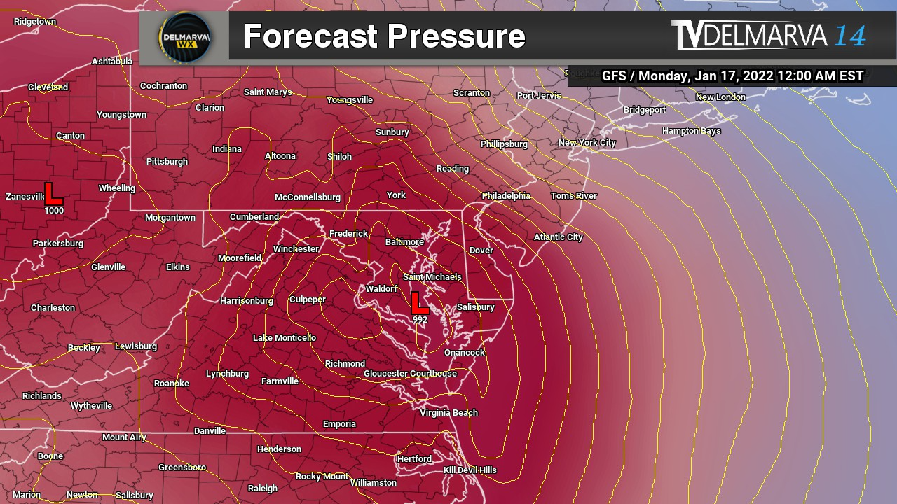
This is going to be the week for heavy rain that is for sure here on Delmarva. Once again we are in the sights of another storm system coming in from the south during the morning hours of Wednesday. An area of low pressure will be developing along the southern jet stream and moving right over top of the Mid-Atlantic States. Areas in PA that saw 70 degree temperatures yesterday will now be seeing some accumulating snowfall.
Although here on the shore we will see all rain, we will get some beneficial amounts to say the least. Latest high resolution guidance showing up to a half inch of precipitation for areas north of Dover. Areas in Central Delmarva up to about an inch of rainfall. And the southern tip of the shore will likely see the greatest amounts between 1- 1.50″ before tapering off Wednesday Afternoon.
Not only we have to deal with some heavy rainfall, a little bit of snow for the northern areas of Delmarva and the Maryland Western Shore. There’s an event that is sleeping under the radar that has my full attention. When that low starts dropping below 990mb, that low level jet stream is very strong being pulled into this surface low.
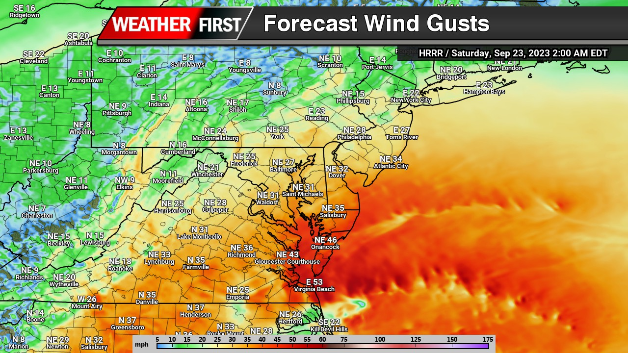
70-80kt Winds at 850mb ( Low Level Jet)
Anytime I start seeing winds at 5000ft getting over 60kts, I get a bit uneasy in the damaging wind department. This is a long fetch stream of onshore winds we are talking about from the Gulf Stream. There is going to be a lot of wind energy pushing on the east side of this low. And it’s all onshore flow too. There’s more issues with this as well.
NAM and GFS Surface Wind Gusts Forecast
Winds at the surface are showing widespread wind gusts of 40-60 mph from the east and southeast. Another problem surfaces as well. We have a high tide cycle that’s expected during the evening hours Sunday Night. To add more salt in the wound, this weekend is a full moon as well. So take 40-60mph surface winds, plus onshore flow, plus a high tide cycle, and a full moon, it’s not going to be a fun time for a coastal locations this weekend. Strongest winds appear to be in a window from 8pm Sunday until 4am Monday.
Already a few tidal forecast in the region showing Moderate Flood Stage forecasts like this one in Crisfield. So we really got to watch our coastal regions Sunday night for flooding concerns.
Many models have trended with a storm system riding up the Eastern Seaboard thanks to the added ingest from an aircraft last night sampling the atmosphere on the West Coast. This created a big shift in the over track and unfortunately for snow lovers, not in a way that favors Delmarva.
GFS timeframe showing Snow/Mix changing to rain across the region
With a low pressure track right over the Peninsula, We will start out with a snow/sleet mix and eventually all locations will be changing over to rain. Delmarva will see that transition fairly quickly but those across the bay on the Maryland Western Shore. They are looking to see a longer duration in the snow & sleet part of the storm thanks to cold air damming along the Appalachian mountains. Eventually they will also change over to rain.
ECMWF/CMC/GEFS all following suite to the blend
With agreement from the ECMWF, CMC, and the GFS Ensembles following the same path, it’s looking that areas of Delmarva will be going from a extremely cold Saturday to a very chilly rain on Sunday. There is still several days away for this storm to be in the region but its not very often / likely these will trend eastward to favor our snow lovers here on the shore.


 ICON Model Output