Tag: coastal storm

  • Potential Coastal Storm This Weekend; Much Colder Air Follows for Delmarva

    Potential Coastal Storm This Weekend; Much Colder Air Follows for Delmarva

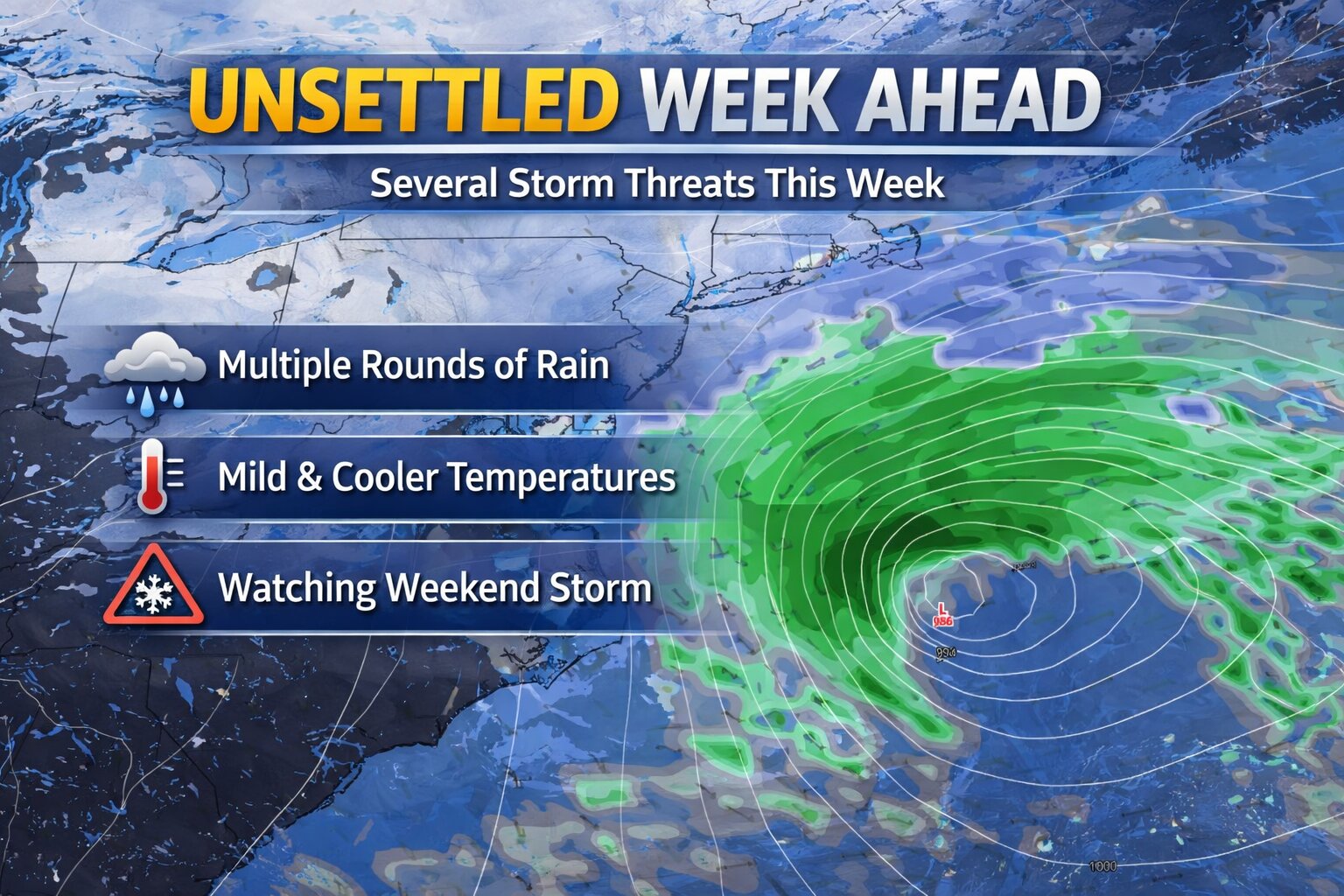
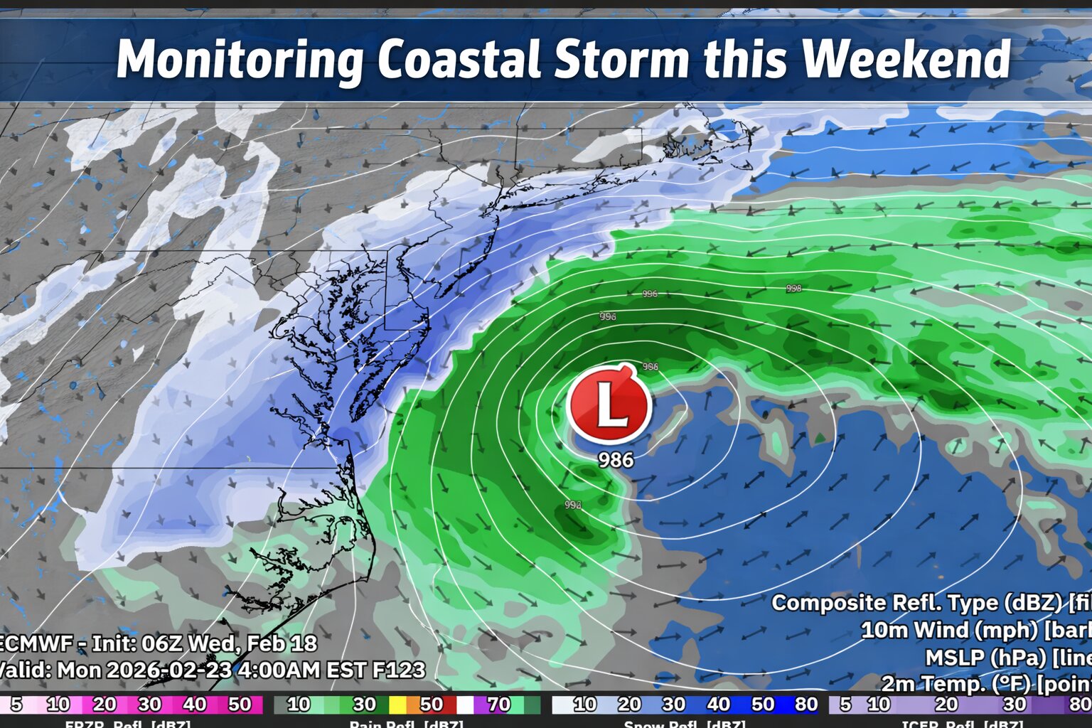
    An active weather pattern continues across the Mid-Atlantic, and are now monitoring the potential for a coastal storm to impact the Delmarva Peninsula during the second half of the weekend.

    While details remain uncertain, confidence is increasing that a developing area of low pressure will track west to east across the region late Sunday before strengthening offshore along the northern Mid-Atlantic coast. But there is also key details I’m not very fond of trusting.

    Storm Track Will Determine Impacts

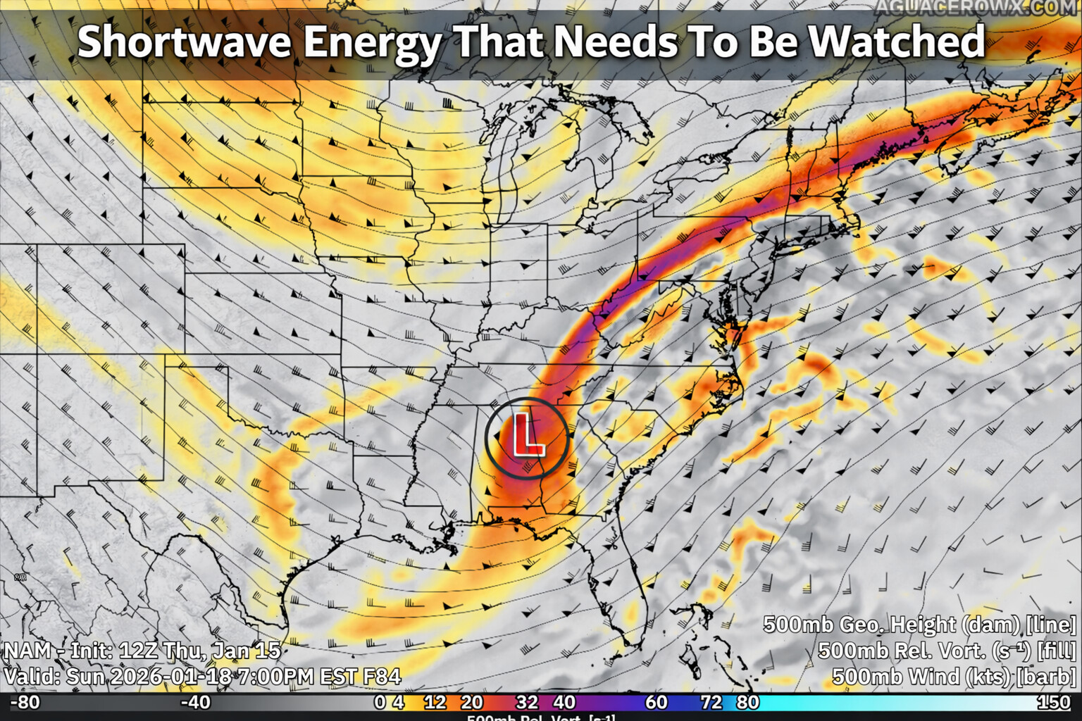
    Most computer models show a storm developing and passing near the region Sunday. However, the exact track and strength of the surface low will ultimately determine how impactful this system becomes for Delmarva.

    Recent trends in both deterministic and ensemble guidance have nudged the system slightly farther south and east. That shift could reduce overall impacts totals locally if it continues. Still, there remains a signal for a widespread precipitation event across the peninsula.

    If the storm tracks close enough to the coast, stronger dynamics could enhance precipitation rates. At this stage, it is too early to determine rain and even snowfall amounts or pinpoint exact impacts.

    Cold Air Will Be Key

    The amount of cold air in place ahead of and during the storm will play a major role in determining precipitation type and accumulation potential.

    Forecast guidance suggests that sufficient cold air may be present for accumulating snow across Delmarva if the storm tracks favorably. However, small shifts in the storm’s path could significantly change the outcome.

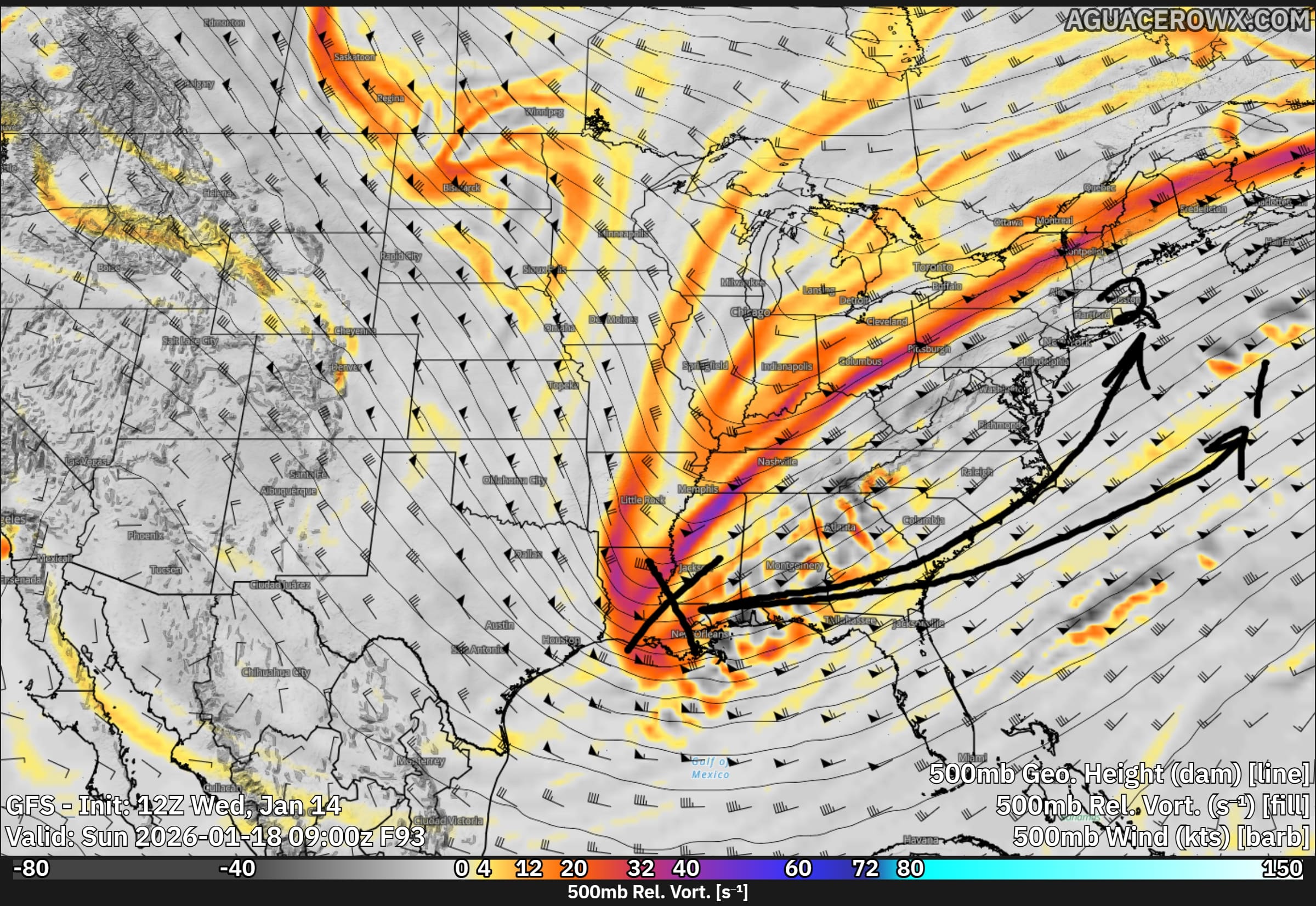
    Relying On a Norlun Trough & Dynamic Cooling Never Fair Well For Delmarva

    A Norlun trough is a narrow, elongated area of low pressure that can develop between two larger weather systems, often in New England or the northern Mid-Atlantic.

    These features often form in cold, unstable air behind a departing coastal storm or between competing pressure systems. They can be difficult to forecast because they are small-scale and highly sensitive to subtle atmospheric changes.

    On Delmarva, Norlun troughs are less common than in New England, but similar narrow deformation bands can produce comparable localized snowfall.

    Dynamic cooling refers to a process where strong upward motion in the atmosphere causes temperatures to cool rapidly, sometimes enough to change rain to snow.

    If precipitation falls heavily enough, it can also contribute to cooling through melting and evaporation, reinforcing the transition to snow.

    Much Colder Air Early Next Week

    Behind the potential weekend storm, a notably colder air mass is expected to settle into the region early next week.

    High temperatures Monday and Tuesday may struggle to climb out of the 30s across Delmarva, with overnight lows dropping into the teens in many locations. The colder conditions could lead to icy spots lingering if snowfall occurs over the weekend.

  • Unsettled Pattern Brings Multiple Rain Chances to Delmarva This Week

    Unsettled Pattern Brings Multiple Rain Chances to Delmarva This Week

    An unsettled weather pattern is setting up across the Mid-Atlantic this week, bringing several opportunities for rain to the Delmarva Peninsula through the weekend. While areas to our north may deal with some wintry precipitation at times, the setup locally favors mainly rain events for Delaware and Maryland’s Eastern Shore.

    Wednesday: Light Rain, Mainly North

    The first system arrives Wednesday into Wednesday night as a warm front lifts northward ahead of low pressure tracking through the Midwest.

    For Delmarva, this looks to be a primarily light rain event. Current trends show the steadiest rainfall staying north of our area, with southern Delaware potentially seeing little to no measurable rain. Most locations across Delmarva should see under a tenth of an inch, though a few spots could pick up slightly more if the rain shield trends farther south.

    Overall, this is not expected to be a high-impact system. However, any rainfall will be beneficial as parts of the region continue to deal with ongoing drought conditions.

    Thursday: Cooler With Spotty Showers Possible

    Behind Wednesday’s warm front, a backdoor cold front may slide southward late Wednesday into Thursday. This front will usher in a cooler maritime air mass from the north or northeast.

    If the boundary settles close enough to Delmarva, some areas could see patchy drizzle or light showers Thursday. Confidence in exact placement remains moderate, so coverage and amounts look limited at this time.

    Friday Into Saturday: Another Round of Rain

    Another low pressure system is expected to move in late Friday into Saturday. As of now, this system also appears to favor rain for Delmarva.

    While slightly cooler air will be in place compared to midweek, temperatures across the peninsula are expected to remain warm enough to support mostly liquid precipitation. At this time, wintry precipitation concerns remain confined well to our north and do not appear to be a factor locally.

    Rainfall amounts will depend on the eventual track and timing of the system, but there is at least some potential for moderate rainfall if the storm strengthens or slows.

    Late Weekend: Watching a Potentially Stronger Storm

    Attention then turns to another possible system toward the end of the weekend. Of all the upcoming disturbances, this one carries the greatest uncertainty and the widest range of possible outcomes.

    Forecast guidance shows everything from a storm tracking well offshore with minimal impact, to a more organized system bringing steadier precipitation to the region. It is still too early to determine specifics, including rainfall amounts or any other impacts.

    At this point, the late weekend system remains in the monitoring phase, and forecast details will likely evolve over the coming days. But with the way weather models have been handling the last several storm systems, it’s hard to put faith in one single solution.

  • Rapidly Intensifying Coastal Storm Could Impact the Region This Weekend

    Rapidly Intensifying Coastal Storm Could Impact the Region This Weekend

    We are closely monitoring a rapidly strengthening coastal storm expected to develop off the East Coast this weekend. While confidence in the exact track and impacts remains low, the system has the potential to bring moderate to significant winter weather impacts to parts of the region, including snow, strong winds, and coastal flooding.

    Forecast guidance continues to show low pressure rapidly developing off the southeastern U.S. coast on Saturday before intensifying and moving north and east Saturday night into Sunday. This storm will strengthen as a powerful upper level disturbance rotates around the base of a large-scale trough over the eastern United States and interacts with a strong temperature contrast along the coastline. This setup is favorable for rapid intensification, which could lead to high-impact weather depending on the storm’s eventual track.

    One of the reasons forecast confidence remains limited is ongoing difficulty within some weather models in accurately handling the storm’s development. Several models are struggling with an issue known as convective feedback. This occurs when the model generates unrealistic high vertical velocities that are too strong or widespread, which in turn creates artificial areas of low pressure that should not exist. These false low pressure centers can disrupt the overall storm structure, leading to errors in the placement of the main low and causing the precipitation shield to appear displaced or unrealistic compared to what may actually occur.

    As a result, small but important details such as where the heaviest snow sets up and how far inland precipitation reaches remain uncertain. This has contributed to notable spread among model solutions, particularly regarding how close the storm tracks to the coast.

    If the storm tracks closer to shore, impacts could begin as early as late Saturday, with the most significant conditions occurring Saturday night into Sunday morning. With very cold air firmly in place at both the surface and aloft, any precipitation that reaches the region would almost certainly fall as snow.

    Probabilistic snowfall data suggests a moderate risk for accumulating snow. The likelihood of at least 2 inches of snow is around 50 percent near the coast and roughly 40 percent along the I-95 corridor, with lower probabilities farther inland. The chance of 6 inches or more increases closer to the coast, reaching around 40 percent, while remaining near 30 percent around the urban corridor. These probabilities remain subject to change as confidence improves.

    Regardless of snowfall totals, increasing winds appear likely. Northerly to northeasterly winds are expected to strengthen Saturday night into Sunday, with gusts of 25 to 35 mph inland and up to 50 mph along the coast. A closer track could result in even stronger winds, raising the risk for power outages, minor structural damage, and hazardous marine conditions. The strong wind field may also contribute to coastal flooding as water is pushed toward the shoreline.

    By Sunday evening, the storm is expected to rapidly pull away to the northeast, with quieter but cold conditions settling in for early next week.

    This storm remains one to watch closely over the coming days. Forecast details should become clearer as additional data is sampled and models better resolve the system. Residents are encouraged to stay informed and prepared for potential winter weather impacts this weekend.

  • Unsettled Weekend Weather Ahead; Coastal Storm Threat Diminishing

    Unsettled Weekend Weather Ahead; Coastal Storm Threat Diminishing

    A developing storm system will bring a period of light snow early Saturday morning before transitioning to rain for many locations as the day goes on. The highest chances for accumulating snow will be found near and northwest of the Interstate 95 corridor, with the greatest totals expected farther north.

    An upper level trough will be positioned over the eastern United States this weekend, allowing several smaller disturbances to move through the region. The first of these systems is expected to arrive during the pre dawn hours on Saturday. As it moves in, increasing lift in the atmosphere and a gradual influx of milder air aloft will help precipitation develop.

    Forecast guidance now suggests the system will be slightly more organized than previously expected. As a result, rainfall totals have increased modestly. Areas near and northwest of I 95 are expected to receive between one tenth and two tenths of an inch of liquid precipitation through Saturday, while locations southeast of I 95 are likely to remain under one tenth of an inch.

    Precipitation is expected to begin mainly as snow early Saturday before gradually changing to rain from southeast to northwest. Little to no snow accumulation is expected southeast of the I 95 corridor before the transition occurs. Near and just northwest of I 95, snowfall amounts should range from a light dusting up to one inch.

    Farther north, including the Lehigh Valley, northwest New Jersey, and the southern Poconos, colder air will allow snow to persist longer. In these areas, snowfall totals are now forecast to reach one to two inches, with up to three inches possible at higher elevations in the southern Poconos where rain mixing may be limited.

    Watching a Coastal System for Sunday

    Attention then turns to a separate storm system expected to develop offshore late in the weekend. This coastal low is forecast to form near the Outer Banks and track northeastward on Sunday. At this time, the overall threat for a significant snowfall remains low.

    Most forecast models continue to favor a track well offshore, which would limit impacts across the region. Under the current forecast, light snow is possible along the coast and areas south and east of I 95 on Sunday, while locations farther inland may see little or no accumulation.

    There is still some uncertainty, as a small number of ensemble models suggest a closer track could occur. However, confidence in that scenario remains low. Probabilities for advisory level snowfall remain modest, generally around 20 to 25 percent at the immediate coast, decreasing farther inland.

    Current snowfall forecasts call for around one half inch to one and a half inches along the coast and southern Delaware, with a coating to one inch possible up to the I 95 corridor. North and west of I 95, only a few flurries or trace amounts are expected.

    Any precipitation associated with this system is expected to taper off Sunday night as the storm pulls farther offshore.

  • Unsettled Weekend Weather Possible Across Delmarva As Coastal System Develops With Snow Threat

    Unsettled Weekend Weather Possible Across Delmarva As Coastal System Develops With Snow Threat

    Residents across the Delmarva region will want to stay weather aware this weekend as multiple rounds of precipitation are possible, including the potential for snow. Forecast confidence remains moderate to low, but the overall pattern supports unsettled conditions from Saturday through Sunday night.

    A broad area of low pressure aloft, known as a longwave trough, will settle over the eastern United States this weekend. Several smaller disturbances moving through this pattern will help generate periods of precipitation, beginning early Saturday and possibly continuing into Sunday night.

    The first system is expected to move through Saturday morning and appears to be relatively weak. Precipitation may begin near or shortly after daybreak, when temperatures are at their coldest. Some locations could see a brief mix or light snow at the onset, especially inland areas, before temperatures rise through the morning. As daytime heating and weak warm air move in, most of Delmarva should transition to light rain. Any snow accumulation during this first round is expected to be minimal, with little more than a trace for most areas. Overall precipitation amounts should remain under a tenth of an inch.

    Attention then turns to a second system that could develop offshore late Sunday into Sunday night. This system carries more uncertainty and higher potential impacts, depending largely on how close the surface low tracks to the coast. Recent forecast guidance has shown a slight shift toward a closer approach, which has increased the chance for precipitation across the region, especially near coastal areas.

    With a cold front moving through Saturday night, colder air will be in place on Sunday. If the offshore low tracks close enough, much of the precipitation could fall as snow, particularly during the latter half of Sunday and into Sunday night. At this time, the probability of seeing measurable snow across coastal Delmarva is around 35 to 50 percent (of greater than 1″), with lower chances farther inland. The likelihood of higher snowfall amounts remains low, but it cannot be ruled out if the storm trends closer to the coast.

    While confidence has increased slightly compared to earlier forecasts, there is still considerable uncertainty regarding the exact track and strength of this system. Residents across Delmarva should continue to monitor the forecast through the weekend, as small changes in storm position could significantly impact precipitation type and amounts.

    More updates will be provided as forecast confidence improves.

  • Will It Storm Or Will It Be Another Dud? The Talk About Sun-Mon Storm Signal

    Will It Storm Or Will It Be Another Dud? The Talk About Sun-Mon Storm Signal

    We are gearing up to be in a fairly hostile pattern with many pieces of energy to play with here over the next 2 weeks as a large long wave trough sits over the eastern US. The biggest issue right now is do they interact with each other or will they remain strung out wasting the potential for snow lovers out there.

    While the overall risk of impactful wintry weather remains low heading into early next week, colder temperatures mean even small changes in the forecast could introduce a chance for snow.

    A brief warm up to near seasonal levels is expected Saturday ahead of a passing cold front. Behind it, a colder pattern looks likely to settle back in and persist through at least the middle of next week, with temperatures running below normal. During this time, several weak disturbances are forecast to move through the region. While none of these systems appear particularly strong on their own, there is a possibility they could interact in a way that brings a wintry weather threat late Sunday into Monday.

    At this time, the most likely outcome would be flurries or light snow, with limited or no accumulation. However, if the shortwave has more of a interaction with the Jetstream, that can bring larger impacts. Forecast confidence remains low, with precipitation chances generally in the 20 to 30 percent range.

    Given the cold air in place, this period will need to be monitored closely for any changes that could increase the wintry weather threat. For now, the risk of a significant winter storm from Sunday into early next week remains low, but not zero.

  • DEMA Mobilizes Delaware National Guard in Preparation for Coastal Storm Effects

    DEMA Mobilizes Delaware National Guard in Preparation for Coastal Storm Effects

    (SMYRNA, DE) — The Delaware Emergency Management Agency (DEMA) has announced the activation of the Delaware National Guard to support preparations and response efforts as the state faces threats from coastal flooding and strong winds expected to persist through tomorrow.

    Having coordinated with state and local officials since Friday, DEMA said it is strategically deploying Guard resources to where they will be needed most. Reception centers are already open across Kent and Sussex counties, with sheltering plans in place should demand increase. Agencies including the Delaware Department of Health and Social Services, DelDOT, and the American Red Cross are working closely with local authorities to facilitate access to these resources.

    In Bowers Beach, the mayor has issued a voluntary evacuation order for residents east of Whitwells Delight Road. Individuals needing shelter are guided to the Magnolia Fire Company or to contact the Kent County Emergency Operations Center at 302-735-3465 for further guidance.

    Reception Center Locations

    • Kent County: Magnolia Fire Hall, 2 North Main Street, Magnolia, DE
    • Sussex County: Millsboro Fire Hall, 109 E State St, Millsboro, DE

    DelDOT continues to monitor road conditions and post closures through its website and mobile app. Meanwhile, DNREC has closed beaches, surf crossings, and campgrounds at Delaware Seashore State Park and Cape Henlopen State Park until further notice.

    DEMA Director A.J. Schall commented, “We’re monitoring the situation and proactively positioning additional resources to support counties and municipalities in safeguarding residents. DEMA will continue to issue Watches, Warnings, and other directives as needed.”

    Officials warn that moderate-to-major coastal flooding, damaging wind gusts, tree damage, power outages, and roadway flooding remain possible. Additional local evacuations may be ordered if conditions worsen.


    Safety Guidelines for Residents

    1. Enroll in DENS – Sign up for the Delaware Emergency Notification System to receive alerts via phone or email.
    2. Know your zone – Use the Know Your Zone tool to determine whether your address falls within an evacuation zone. Stay alert even if you are outside a designated zone.
    3. Plan your evacuation – Outline a route, inform family members, and carry hard copies of important documents.
    4. Assemble an emergency kit – Include essentials such as medications, food, water, batteries, flashlights, and supplies for pets for 3–7 days.
    5. Stay informed – Monitor trusted media, state agencies’ social accounts, and radio stations for updates.
    6. Turn Around, Don’t Drown – Never drive through floodwaters.

    Emergency Alert Radio Stations: WDEL-AM 1150, WDEL-FM 101.7, WCHK-FM 101.3, WWTX-AM 1290, WRDX-FM 92.9, WJWL-AM 900, WDOV-AM 1410, WSTW-FM 93.7, WDDE-FM 91.1, WILM-AM 1450, WDSD-FM 94.7. Boaters should monitor Marine Channel 16

  • Winter Storm Safety: Delaware State Police and DelDOT Issue Snow Safety Tips

    Winter Storm Safety: Delaware State Police and DelDOT Issue Snow Safety Tips

    Dover DE:

    As the snow continues to fall across Delaware, state officials are emphasizing safety measures for all residents. The Delaware State Police have issued a series of guidelines aimed at keeping motorists safe during the winter weather:

    • Stay Home if Possible: If you can avoid travel, do so. Conditions can be unpredictable and hazardous.
    • Drive Cautiously: For those who must travel, slow down, keep a safe distance from other vehicles, and ensure your vehicle is free of snow and ice to prevent accidents.
    • Emergency Preparedness: Carry an emergency kit in your car with items like blankets, a flashlight, food, and water. Check road conditions via official channels before setting out.
    • Respect Snow Plows: Do not attempt to pass or crowd snow removal vehicles. The Delaware Department of Transportation (DelDOT) crews are diligently working to clear the roads, and they need space to operate safely.

    DelDOT has expressed gratitude towards their crews for their relentless efforts during the storm, urging the public to assist by not crowding the plows.

    The Delaware Emergency Management Agency (DEMA) also reminds everyone to check on neighbors, particularly the elderly or those who might need assistance during this time.

    With these safety tips in mind, Delawareans are encouraged to take extra precautions as the winter weather persists. Your safety, and the safety of those around you, is paramount.

  • Coastal Storm Possible This Weekend

    Coastal Storm Possible This Weekend

    After a period of very dry and chilly conditions over the weekend and throughout much of this week, we have a potential storm looming towards the weekend. Computer guidance has been hinting at a Miller B type of coastal storm to sweep across the northern tier of the nation and redeveloping a coastal low right off to our east.

    “Miller B Nor’easters is a low pressure system first tracks over the Midwest, bringing a swath of rain, sleet or snow to parts of the Plains. This storm generally moves into the Kentucky/Ohio River Valley before it starts to transfer energy to a newly forming low pressure system along the coast of North Carolina and Virginia. From here, the newly redeveloped storm takes a northerly path before making a turn out to sea.”.

    Our storm first develops across the Central Plains as a fairly strong system already on Friday before heading into our region on Saturday with rain and breezy conditions. Then the low begins to transfer off the coast of us and begins to redevelop with increasing northeasterly winds. European model ensembles really show a very good cluster of low centers right off the coast of Jersey showing there is a good potential for this to occur. So more than likely, get ready for more wind, rain, and coastal flooding going into the weekend with the new moon ahead.

  • Tropical Troubles Into The Weekend

    Tropical Troubles Into The Weekend

    A big tone shift with the overnight model runs shows full speed ahead of a tropical system moving in from the Carolinas up into the Chesapeake Bay region. Which is the worst case scenario for any track of a storm system here on the shore.

    Many of the high resolution model guidance showing heavy rain beginning to move in starting in the evening hours on Friday from south to north as the winds start to increase from the east. Winds could be gusting as high as 50 mph along the coastlines with 40-50 for the inland locations. Along with the major waves coming ashore of 10-20 feet. Combination of a high tide cycle, heavy rainfall, strong long fetched onshore winds, coastal flooding is going to be a big problem.

    Early indications from a few days ago had flooding in the minor to borderline moderate levels. Well with high confidence now with the storm track and overall strength, moderate to potential major levels of coastal flooding exist for all water ways along the Atlantic, Delaware Bay, and of course the inland bays in Sussex, Kent and Worcester counties. Inundation of 1-3 feet are on the table on Saturday.

    Rainfall with tropical moisture is surely going to be a issue for areas along coastal Delaware down the Bay Bridge Tunnel. across the mid-shore we will average of 2 to 5 inches of rain. Highest for those farthest south and east.

    Now my least favorite topic, tornadoes. If we do have a tropical system on our hands rather than a hybrid or extra tropical cyclone, being on the right side of it is never a good thing. Slight curvature in the hodographs suggest we do have some turning in the atmosphere. Whether we have the little bit of instability remains to be in question. Tornadoes are a possibility but not with very high confidence right now.

    Prepare for a potentially major storm system heading into this weekend.

  • *** Hybrid Storm Expected This Weekend / Wednesday Update ***

    *** Hybrid Storm Expected This Weekend / Wednesday Update ***

    Confidence continues to increase for some sort of sub-tropical in nature storm system to develop along a stalled out frontal boundary off the coast of Florida and Georgia. With a strong area of high pressure it place towards New England, this will allow this system to intensify and move in towards the Carolina coastlines late Friday through Sunday.

    Overspreading heavy rain, gusty winds, and coastal flooding are all expected this weekend. Especially on Saturday when the conditions are expected to be the worst out of this storm. Whether this storm will be tropical in nature or not, impacts are going to be felt like a stronger nor’easter we would see in the winter months.

    Rain will begin to overspread the region beginning during the overnight hours on Friday and picking up in intensity on Saturday. Rain will be heavy at times with many operational and ensemble mean totals of 2-5 inches are expected over the weekend. With an area of high pressure to north, a strong pressure gradient will setup with constant strong onshore winds from the east and northeast. Sustained winds of 20-30 MPH with gusts 40-50 mph at times, will help generate waves offshore 10-20 feet. Near the coast, we are looking at swells generating 7-12 feet.

    With some of the the tide gauge forecasts as of now showing areas along the Atlantic Ocean and Inland Bay regions for Minor to even Moderate coastal flooding during the high tide cycle Saturday afternoon. I worry for the Inland Bays a lot more with all the water being forced with no where to go given how big the swells will be with the strong long fetched onshore winds.

    It’s pretty definitive at this point that we have a coastal storm on the way, it’s just a matter of how much rain will be associated with this system, and if it happens to be tropical or not. Or even a combination of both being a hybrid sub-tropical system. More details will be provided as the week goes on.

  • Hybrid Coastal Storm Impacting Delmarva This Weekend

    Hybrid Coastal Storm Impacting Delmarva This Weekend

    With the potential hybrid storm coming this weekend, not only heavy rain and gusty onshore winds are a problem, these are going to be some big waves. Moderate coastal flooding is on the table for Saturday. With onshore winds of 40-50 mph wind gusts generating waves 10-20 feet offshore. That’s going to be driving water hard to the coastal locations. Inland bays will be the bigger issues where water will not have any place to go.

    We still have days to go to see the full extent of details but the consistency in model guidance is very good with this one so far. Whether this will be a tropical system or a nor’easter, this will be bringing heavy rains, gusty winds, and coastal flooding.

  • High Wind Event With Coastal Flooding Concerns Sunday Night

    High Wind Event With Coastal Flooding Concerns Sunday Night

    Not only we have to deal with some heavy rainfall, a little bit of snow for the northern areas of Delmarva and the Maryland Western Shore. There’s an event that is sleeping under the radar that has my full attention. When that low starts dropping below 990mb, that low level jet stream is very strong being pulled into this surface low.

    70-80kt Winds at 850mb ( Low Level Jet)

    Anytime I start seeing winds at 5000ft getting over 60kts, I get a bit uneasy in the damaging wind department. This is a long fetch stream of onshore winds we are talking about from the Gulf Stream. There is going to be a lot of wind energy pushing on the east side of this low. And it’s all onshore flow too. There’s more issues with this as well.

    Winds at the surface are showing widespread wind gusts of 40-60 mph from the east and southeast. Another problem surfaces as well. We have a high tide cycle that’s expected during the evening hours Sunday Night. To add more salt in the wound, this weekend is a full moon as well. So take 40-60mph surface winds, plus onshore flow, plus a high tide cycle, and a full moon, it’s not going to be a fun time for a coastal locations this weekend. Strongest winds appear to be in a window from 8pm Sunday until 4am Monday.

    Already a few tidal forecast in the region showing Moderate Flood Stage forecasts like this one in Crisfield. So we really got to watch our coastal regions Sunday night for flooding concerns.

  • Major Coastal Storm On The Way Sunday-Monday

    Major Coastal Storm On The Way Sunday-Monday

    GFS Model Output For Sunday

    A very dynamic storm system is on the way for the Eastern US going into this weekend. Widespread areas of heavy snow, freezing rain, sleet, and rainfall are all on the table stretching from the deep south all the way into New England. A classic Miller-B type of Nor’easter.

    500MB Pattern

    Storms that come in from the west (up the Ohio Valley) are usually referred to as “Miller Type-B” storms. These storms produce precipitation in the Midwest/Ohio Valley and have a defined surface low that is moving toward the Appalachian Mountains from the west. As these storms approach the mountains, they lose their coherent/compact surface low center and the low re-develops along the East Coast. When this re-development (a.k.a. “center-jump”) happens, the storm can still produce snow over all of the state.

    With a storm diving straight from Canada across the Northern Plains will run directly into the sub-tropical jet-stream. Tapping into moisture from the Gulf of Mexico to really give some power to this low. I have a big concern for those in the Western Carolina’s and Northern Georgia regarding the ice threat. With cold air damming present along the Appalachians and the arctic high to the north, this is not a good situation for residents in the Southeast US.

    With the energy associated with this system now over land on the West Coast, we are getting a fairly firm track on where this system is going to go. Unfortunately those on Delmarva hoping for another big snowstorm, this is not the one. With a track of the low pressure right over the Peninsula, a lot of warm air will surge in. Although areas may start off as a snow/sleet mix will change over to all rain once the low pressure center gets closer. Our friends on the Maryland Western Shore will have a little bit longer duration of snow and sleet thanks to Cold Air Damming before they will change over to all rain as well.

    Snow Depth Forecast

    Those who live along the Appalachian mountains in Western North Carolina, Virginia, West Virginia, and Central PA are in for a doozy of a snowstorm Sunday and Monday. Widespread areas of 6 plus are definitely likely. Areas like Washington DC through Frederick Maryland could sneak in some light accumulations at the start being turning into a sloppy mess once temperatures start rising above freezing when the low approaches.

  • Big Storm On The Way Sun-Mon / Snow Lovers Won’t Be Happy With This One

    Big Storm On The Way Sun-Mon / Snow Lovers Won’t Be Happy With This One

    Surface Pressure Forecast

    We gave out two different solution tracks in yesterday’s update but now we have a agreement on which one it would be. If you guessed number 1? You are right (sort of). For reference to yesterday’s post –> https://tvdelmarva.com/storm-signal-jan-16-17th-winter-storm-looming/

    Many models have trended with a storm system riding up the Eastern Seaboard thanks to the added ingest from an aircraft last night sampling the atmosphere on the West Coast. This created a big shift in the over track and unfortunately for snow lovers, not in a way that favors Delmarva.

    With a low pressure track right over the Peninsula, We will start out with a snow/sleet mix and eventually all locations will be changing over to rain. Delmarva will see that transition fairly quickly but those across the bay on the Maryland Western Shore. They are looking to see a longer duration in the snow & sleet part of the storm thanks to cold air damming along the Appalachian mountains. Eventually they will also change over to rain.

    With agreement from the ECMWF, CMC, and the GFS Ensembles following the same path, it’s looking that areas of Delmarva will be going from a extremely cold Saturday to a very chilly rain on Sunday. There is still several days away for this storm to be in the region but its not very often / likely these will trend eastward to favor our snow lovers here on the shore.