Tag: sleet

  • SNEAKY ICING EVENT ON BOXING DAY DEC 26-27TH?

    SNEAKY ICING EVENT ON BOXING DAY DEC 26-27TH?

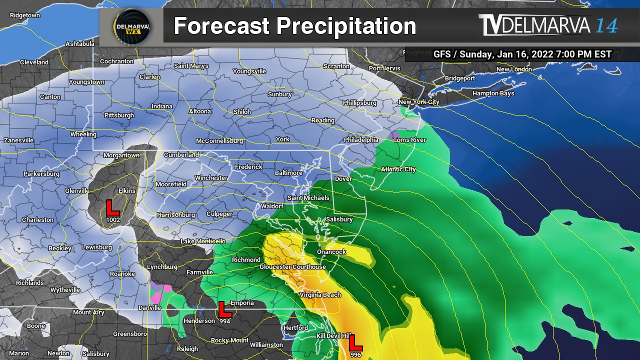
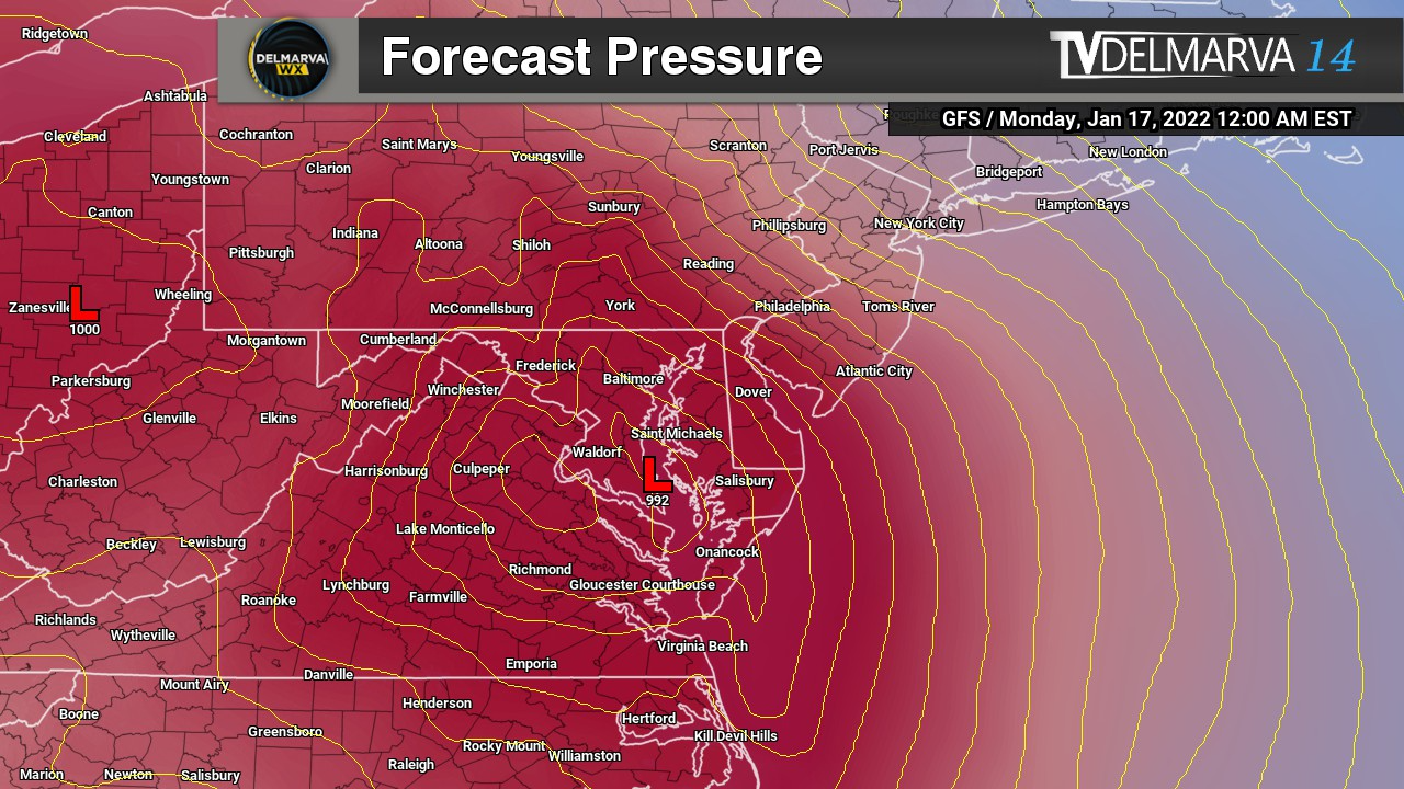
    December 26-27th event has been a model guidance nightmare these past few days so that’s why i haven’t really talked much about it. Because at one moment its a 63 degree day with rain and then next minute its a day with accumulating snow and ice. This is very typical back and forth nonsense that happens in the 84-120hr timeframe so i don’t put a whole lot of weight to it. But we are starting to get into the sub 84 timeframe where they begin to get their act together. So here is the setup.

    We will already have a push of arctic air in place out ahead of a weak disturbance with a warm front nosing into the cold air. This is a classic representation of what we call a “Overrunning Event”

    An overrunning event in winter meteorology occurs when warm, moist air is lifted up and over a shallow layer of cold air at the surface. This setup is common ahead of winter storms and often develops north of a warm front. Because cold air is denser, it remains trapped near the ground while warmer air flows over it along sloping isentropic surfaces.

    As the rising warm air cools, clouds and precipitation develop well in advance of the main storm system. In winter, this frequently leads to widespread, long-duration precipitation, often falling as snow, sleet, or freezing rain, depending on the temperature profile of the atmosphere. Overrunning events are typically associated with stratiform precipitation, lower visibility, and steady rather than convective rainfall or snowfall.

    These events can produce significant winter weather impacts, including heavy snow accumulations, ice accretion, and hazardous travel conditions, especially when cold air is reinforced at the surface by high pressure to the north. Overrunning precipitation often marks the initial phase of a winter storm before stronger dynamics and surface low pressure move in.

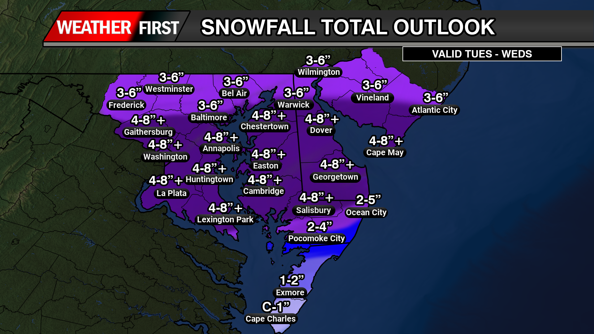
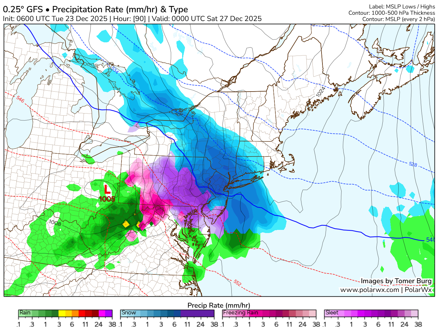
    With the latest mid day mid range guidance rolling in they are starting to come into light of a icing scenario beginning to unfold across areas of central and northern Delmarva, northern Maryland, and portions of South Jersey. A lot of factors remain in place like will the cold air remain more locked in and keep the warm nose at bay, will the warm nose make it a widespread icing event, or will the warm nose overwhelm the environment and keep it more of a rain threat in the region. Those are the details we need to iron out going later into the week.

  • Significant Winter Storm Set to Impact the Delmarva Region Tuesday into Wednesday

    Significant Winter Storm Set to Impact the Delmarva Region Tuesday into Wednesday

    Another winter storm is set to impact the region as we move into Tuesday and Wednesday, bringing a mix of heavy snow, ice, and rain across the Delmarva Peninsula. Snow and wintry precipitation will begin Tuesday afternoon and continue through Wednesday morning, leading to widespread travel disruptions and hazardous conditions.

    This storm is developing as a new area of low pressure forms over the Deep South and tracks northeastward along a stalled frontal boundary. At the same time, a strong high-pressure system to the north will funnel cold air into the region, setting the stage for a classic overrunning event. In this setup, warm, moisture-laden air from the Gulf of Mexico moves over the dense, cold Arctic air advancing southward from Canada, creating widespread heavy snowfall from the Midwest into the Mid-Atlantic. This process, known in meteorology as isentropic ascent, drives the formation of clouds and precipitation as the warm air rises and cools.

    In a winter storm overrunning setup, isentropic ascent occurs when warm, moist air is forced to rise over a cold, dense air mass at the surface. This typically happens along a stationary front or warm front, where the warm air follows sloping isentropic surfaces (constant potential temperature). As the air rises, it cools adiabatically, leading to cloud formation and precipitation.

    Since winter storms involve subfreezing surface temperatures, this precipitation can fall as snow, sleet, or freezing rain, depending on the temperature profile. Stronger isentropic ascent enhances moisture transport and lift, leading to heavier and more widespread winter precipitation.

    Snowfall Potential and Accumulation Estimates

    The latest ensemble model guidance indicates a significant increase in snowfall probabilities across central and northern Delmarva. There is now a 60-90% chance of at least 3 inches of snow north of the Maryland-Delaware state line, with 40-60% probabilities for accumulations exceeding 6 inches from Delmar, DE to Smyrna, DE.

    The heaviest snowfall totals are expected between the MD/DE line and Smyrna, where an average of 4 to 8 inches is forecast. This extends westward toward Washington, D.C.. However, localized snow bands could produce isolated totals up to 10 inches, particularly across central Delmarva.

    Coastal and Southern Delmarva Impacts

    Further south, near the coastal areas including Berlin and Pocomoke City, the storm will begin as snow but may transition to a mix of snow, sleet, and rain as temperatures rise above freezing. This will reduce overall snowfall totals due to melting overnight Tuesday into early Wednesday.

    Meanwhile, areas further north will remain all snow, though the intensity may be slightly lower compared to central Delmarva. Regardless, this storm is shaping up to be a significant winter weather event across the region, bringing hazardous travel conditions and potential disruptions.

    Stay tuned for updates as forecast details continue to evolve.

  • Wintry Mix Threatens Central and Northern Delmarva Again with Ice Accretion and Slick Travel This Weekend

    Wintry Mix Threatens Central and Northern Delmarva Again with Ice Accretion and Slick Travel This Weekend

    A complex winter weather system is set to impact portions of central and northern Delmarva, bringing a mix of snow, sleet, and freezing rain as temperatures hover near the freezing mark towards early Saturday afternoon. This system will create hazardous travel conditions, especially in areas where freezing rain leads to ice accretion.

    Weather Setup and Model Guidance

    Latest guidance from the ICON, GFS, and ECMWF suggests that cold air at the surface will remain entrenched across northern Delmarva, allowing for a prolonged period of wintry precipitation before a gradual changeover to rain. Meanwhile, high-resolution CAMS guidance, including the HRW-WRF & NAM12KM, continues to highlight higher localized areas of ice accumulation, particularly in northern regions where cold air remains stubborn.

    As the system moves through, precipitation is expected to start as a wintry mix of snow, sleet, and freezing rain across northern and central Delmarva, with surface temperatures struggling to rise above 32°F. By early afternoon, warmer air aloft will cause much of central Delmarva to transition to plain rain, while northern Delmarva may see continued ice accretion before the system exits early Sunday.

    Potential Ice Accretion and Travel Hazards

    • Ice Accumulation: Up to 0.10” of ice is possible across northern & central Delmarva, with localized higher amounts in areas where freezing rain persists.
    • Travel Impacts: Slick roadways and hazardous conditions are expected, particularly on bridges and overpasses. Untreated surfaces may become icy and dangerous.
    • Timing: The wintry mix will continue through early afternoon, with a gradual transition to rain in central Delmarva through the evening hours. Northern areas may hold onto freezing rain longer before precipitation moves out early Sunday morning.

    Stay Weather Aware

    Residents across central and northern Delmarva should stay updated with the latest forecasts, as even small changes in temperature could impact precipitation type and ice accumulation. If traveling, exercise caution and allow extra time, especially in areas where freezing rain may linger.

  • Major Coastal Storm On The Way Sunday-Monday

    Major Coastal Storm On The Way Sunday-Monday

    GFS Model Output For Sunday

    A very dynamic storm system is on the way for the Eastern US going into this weekend. Widespread areas of heavy snow, freezing rain, sleet, and rainfall are all on the table stretching from the deep south all the way into New England. A classic Miller-B type of Nor’easter.

    500MB Pattern

    Storms that come in from the west (up the Ohio Valley) are usually referred to as “Miller Type-B” storms. These storms produce precipitation in the Midwest/Ohio Valley and have a defined surface low that is moving toward the Appalachian Mountains from the west. As these storms approach the mountains, they lose their coherent/compact surface low center and the low re-develops along the East Coast. When this re-development (a.k.a. “center-jump”) happens, the storm can still produce snow over all of the state.

    With a storm diving straight from Canada across the Northern Plains will run directly into the sub-tropical jet-stream. Tapping into moisture from the Gulf of Mexico to really give some power to this low. I have a big concern for those in the Western Carolina’s and Northern Georgia regarding the ice threat. With cold air damming present along the Appalachians and the arctic high to the north, this is not a good situation for residents in the Southeast US.

    With the energy associated with this system now over land on the West Coast, we are getting a fairly firm track on where this system is going to go. Unfortunately those on Delmarva hoping for another big snowstorm, this is not the one. With a track of the low pressure right over the Peninsula, a lot of warm air will surge in. Although areas may start off as a snow/sleet mix will change over to all rain once the low pressure center gets closer. Our friends on the Maryland Western Shore will have a little bit longer duration of snow and sleet thanks to Cold Air Damming before they will change over to all rain as well.

    Snow Depth Forecast

    Those who live along the Appalachian mountains in Western North Carolina, Virginia, West Virginia, and Central PA are in for a doozy of a snowstorm Sunday and Monday. Widespread areas of 6 plus are definitely likely. Areas like Washington DC through Frederick Maryland could sneak in some light accumulations at the start being turning into a sloppy mess once temperatures start rising above freezing when the low approaches.

  • Big Storm On The Way Sun-Mon / Snow Lovers Won’t Be Happy With This One

    Big Storm On The Way Sun-Mon / Snow Lovers Won’t Be Happy With This One

    Surface Pressure Forecast

    We gave out two different solution tracks in yesterday’s update but now we have a agreement on which one it would be. If you guessed number 1? You are right (sort of). For reference to yesterday’s post –> https://tvdelmarva.com/storm-signal-jan-16-17th-winter-storm-looming/

    Many models have trended with a storm system riding up the Eastern Seaboard thanks to the added ingest from an aircraft last night sampling the atmosphere on the West Coast. This created a big shift in the over track and unfortunately for snow lovers, not in a way that favors Delmarva.

    With a low pressure track right over the Peninsula, We will start out with a snow/sleet mix and eventually all locations will be changing over to rain. Delmarva will see that transition fairly quickly but those across the bay on the Maryland Western Shore. They are looking to see a longer duration in the snow & sleet part of the storm thanks to cold air damming along the Appalachian mountains. Eventually they will also change over to rain.

    With agreement from the ECMWF, CMC, and the GFS Ensembles following the same path, it’s looking that areas of Delmarva will be going from a extremely cold Saturday to a very chilly rain on Sunday. There is still several days away for this storm to be in the region but its not very often / likely these will trend eastward to favor our snow lovers here on the shore.