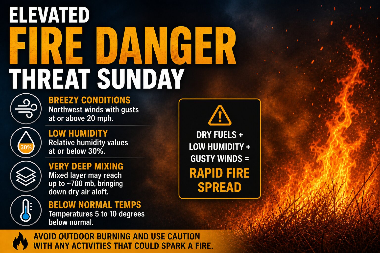
An increased risk for fire spread is expected to develop across the Delmarva region on Sunday as a dry and breezy weather pattern takes hold behind a departing offshore storm system.
As the coastal low pulls farther out to sea, high pressure will begin building in from the southeastern United States. This setup will tighten the pressure gradient locally, leading to a strengthening northwest wind across the region. At the same time, the atmosphere is expected to mix deeply during the day, allowing very dry air from aloft to be transported down to the surface.
Forecast soundings indicate an unusually deep mixed layer for this time of year, potentially extending up to around 700 mb. This efficient vertical mixing will help drive down dew points more than typical model guidance suggests, especially given the tendency for models to overestimate moisture in springtime patterns like this. As a result, relative humidity values are expected to fall to around or below 30 percent during the afternoon hours.
Even though temperatures will run slightly below average, generally about 5 to 10 degrees cooler than normal, the combination of dry air and increasing winds will create an environment supportive of fire growth. Wind gusts are expected to reach 20 mph or higher at times, which, when combined with low humidity, can allow any fires that ignite to spread quickly.
The overall fire risk will ultimately depend on the condition of local fuels, but given the recent dry stretch across parts of the region, the potential for rapid fire spread cannot be ruled out. Residents are urged to avoid outdoor burning and to exercise caution with any activities that could produce sparks.
Conditions are expected to improve later Sunday evening as winds begin to diminish and humidity levels recover.
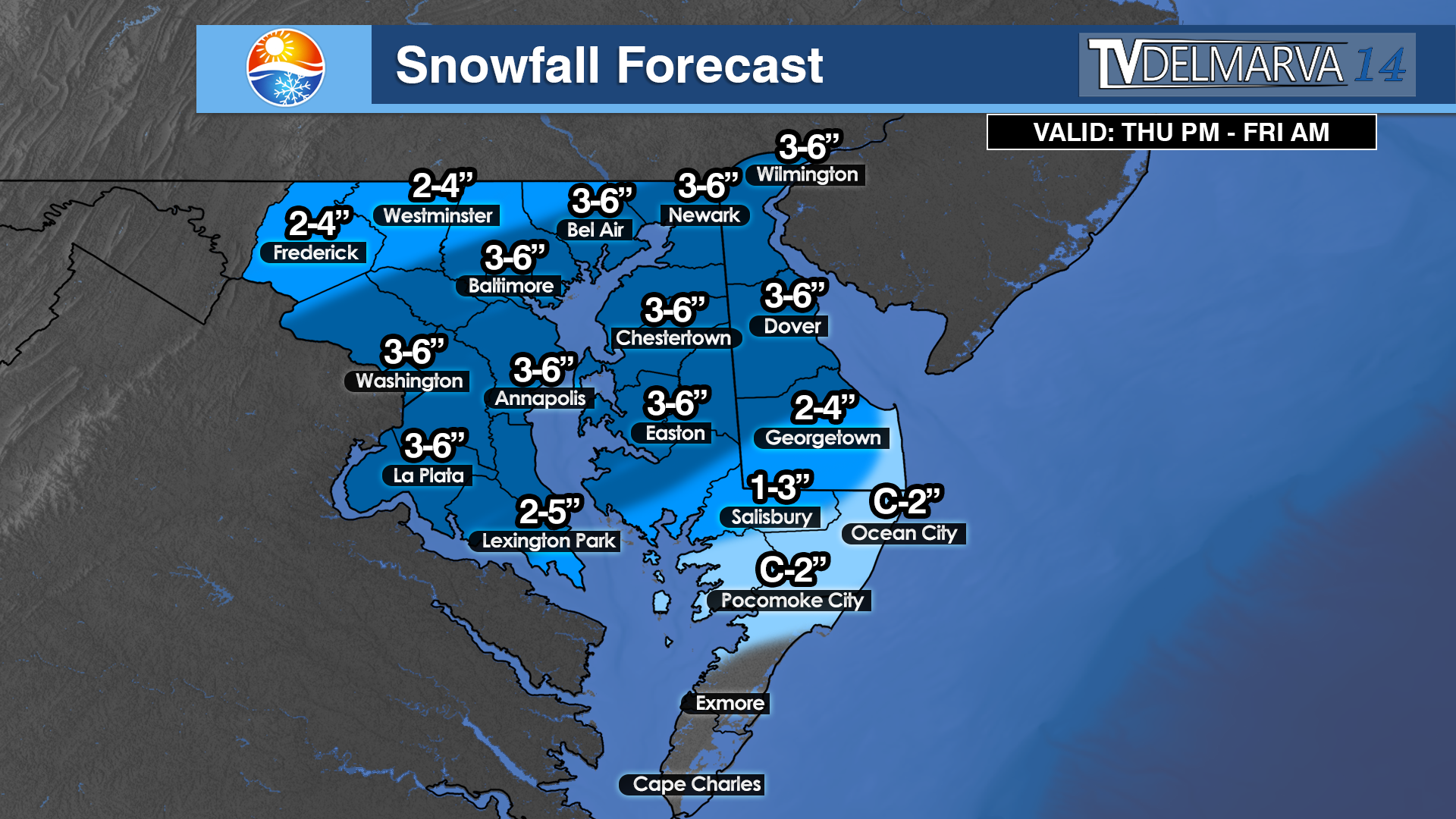
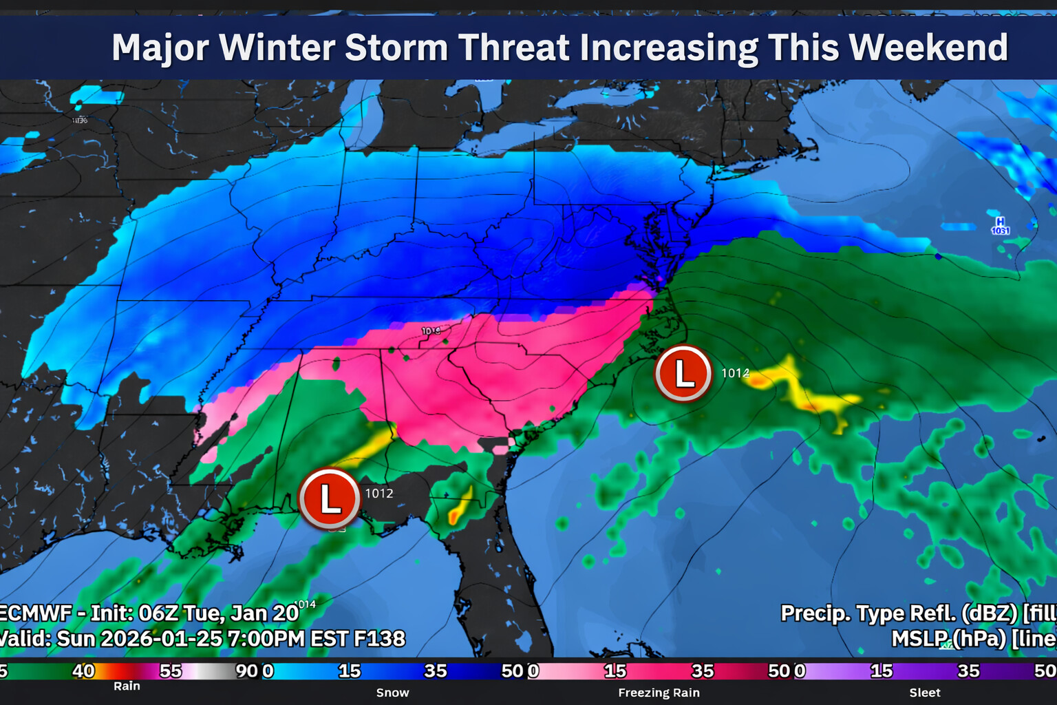
Forecast confidence is increasing that a potentially impactful winter storm could affect the Delmarva region late Saturday through Sunday, though important details regarding track and snowfall amounts remain uncertain at this time.
Weather patterns aloft are becoming increasingly active as we head toward the weekend, with interactions expected between northern and southern jet stream systems. The energy driving this setup is currently located over the Arctic and the Pacific Ocean, meaning it will take several more days for forecasts to fully resolve how this system evolves. Even so, most forecast guidance now consistently shows an area of low pressure developing near Texas on Friday before moving east along the Gulf Coast into Saturday.
As the system approaches the East Coast, guidance generally favors the low tracking northeast toward the North Carolina coast before moving offshore late Sunday into early Monday. This type of track would place Delmarva on the colder, northern side of the storm, increasing the potential for winter weather impacts across the region. A key question remains how close the storm tracks to the coastline, as even small shifts could have a major influence on snowfall totals.
A strong arctic high pressure system will be positioned to the north, supplying cold air into the Mid Atlantic. Earlier forecast guidance suggested this high might suppress the storm farther south, limiting impacts locally. However, trends over the past 12 to 24 hours show the storm track edging farther north, increasing the likelihood that precipitation spreads into Delmarva.
Snow probabilities have responded accordingly. Current guidance now indicates a 75 to 95 percent chance of at least 2 inches of snow and a 70 to 85 percent chance of 6 inches or more for areas along and south of the Interstate 95 corridor, with probabilities decreasing farther north.
Even more impressive with NBM blends of >12 inches of snow are between 50-60% as of this morning. These numbers are notably higher than those from previous forecast cycles and point toward a growing signal for a meaningful winter weather event.
If this storm materializes, snowfall could begin late Saturday and continue through Sunday, with the potential for lingering impacts into Monday depending on how quickly the system moves away. While confidence in exact snowfall totals remains low, the overall signal for a winter storm affecting at least part of Delmarva is stronger than typically seen at this lead time.
It is important to note that East Coast winter storms often produce narrow bands of heavy snow, sometimes only 50 to 100 miles wide. With the storm’s key ingredients still thousands of miles away, it is far too early to determine which specific locations will see the highest accumulations. Residents across Delmarva should continue to monitor forecast updates closely over the coming days as details become clearer.
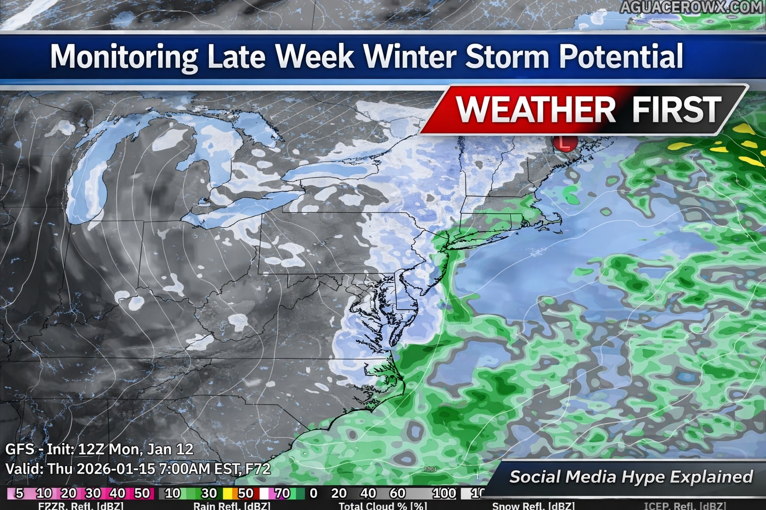
Forecast guidance continues to signal the potential for a disruptive winter weather pattern later this week, mainly from Wednesday through Friday, as an upper level low strengthens over the Lower Great Lakes and moves toward the Northeast. This system is expected to bring an increase in wintry precipitation across parts of the Lower Great Lakes, the central Appalachians, and portions of the interior Northeast, with colder air also setting the stage for lake effect snow in typical snowbelt regions.
However, confidence in the overall setup remains low. Key details such as the exact placement and strength of the upper level low are still uncertain, which will ultimately determine where the heaviest precipitation develops. There is also considerable question surrounding coastal low development, including whether it forms too late, remains weak, or tracks well offshore. Recent trends as of today favor a later developing system that stays farther out to sea, which would significantly limit impacts for much of the I-95 corridor.
The primary question for Delmarva centers on whether a coastal low is able to develop in time and close enough to influence the region. Current guidance shows large spread in both timing and track, with recent trends favoring a system that forms too late and remains well offshore. If this trend holds, meaningful winter weather impacts across Delaware, eastern Maryland, and Virginia’s Eastern Shore would be limited or possibly avoided altogether.
Because of these uncertainties, forecast impacts to travel and infrastructure remain unclear at this time. While some wintry weather is possible inland, especially across higher elevations and areas closer to the Great Lakes, any coastal impacts would depend on how quickly and how close a coastal low can organize. Forecast confidence should improve over the next few days as the system comes into better range of higher resolution models.
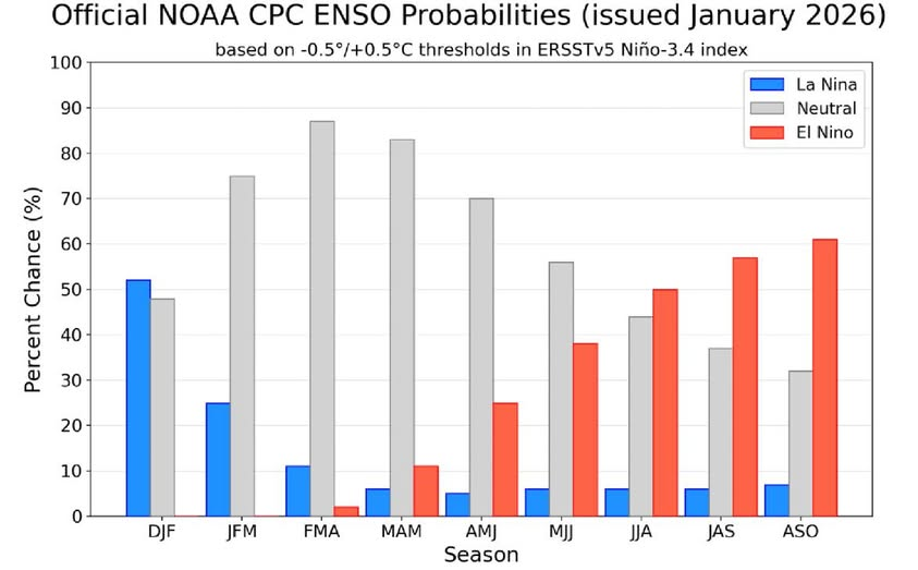
The latest climate update from the Climate Prediction Center, part of the National Oceanic and Atmospheric Administration, shows that the ongoing La Nina pattern in the Pacific Ocean is weakening. Forecasters say a transition toward more neutral conditions is expected over the next few months.
La Nina is a climate pattern marked by cooler than normal sea surface temperatures across the central and eastern tropical Pacific Ocean. These cooler waters have persisted into early 2026, based on recent ocean temperature observations. While La Nina remains in place, its influence is beginning to fade.
According to NOAA, there is about a 75 percent chance that the Pacific will move into ENSO neutral conditions between January and March 2026. ENSO neutral means the Pacific is not in either a La Nina or El Nino phase. Forecast models suggest these neutral conditions could last through at least late spring.
One of the main signals supporting this shift is warming water beneath the ocean surface. Warmer water that had been confined to the western Pacific is now spreading eastward, helping to weaken the remaining La Nina pattern. While some atmospheric features still resemble La Nina, key wind and temperature signals are gradually trending toward neutral.
Forecasters caution that even after sea surface temperatures return to neutral, lingering impacts from La Nina could still influence weather patterns during early spring. Looking further ahead, there is increasing potential for El Nino to develop later in 2026, although confidence in that part of the forecast remains lower at this time.
NOAA continues to monitor ocean and atmospheric conditions closely and will provide regular updates as the Pacific climate pattern evolves. These outlooks help forecasters, emergency planners, and the public prepare for seasonal weather changes influenced by shifts in the tropical Pacific.
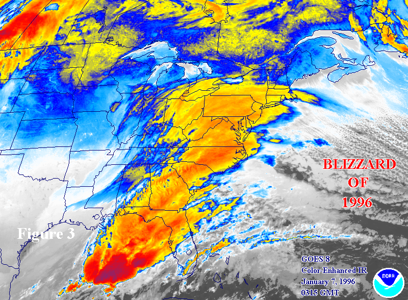
This winter marks 30 years since one of the most powerful and memorable winter storms in Mid-Atlantic history — the Blizzard of 1996. From January 6 through January 8, a classic nor’easter buried much of the Eastern United States under a historic blanket of snow, bringing life to a standstill from Virginia all the way to southern New England. Thirty years later, the effects of that storm remain part of the weather lore of communities across the Delmarva Peninsula.
A Storm that Shut Down the Region
The Blizzard of ’96 was not simply a big snowstorm, it was a paralyzing meteorological event. Fueled by abundant Gulf moisture lifting into frigid Arctic air, the storm produced heavy snowfall, fierce winds, and drifts as high as 5 to 8 feet in places, and it cut off normal travel and commerce for days. More than 20 inches of snow was common from the Smoky Mountains to the Northeast, with Baltimore alone recording more than 22 inches.
Across the broader Mid-Atlantic, most major airports closed, highways like Interstate 95 became impassable, government and business operations shut down, and utility outages were widespread as heavy snow and strong winds downed trees and power lines.
Delmarva’s Experience: Snow, School Closures, and Water Issues
Although Delmarva lies on the more southern and coastal edge of the storm’s heaviest snow, many parts of the Eastern Shore still saw significant impacts. In Delaware and Maryland’s eastern counties, reports from regional accounts show that snowfall totals often reached into the teens across Delmarva, with southern and interior areas picking up even more as the storm slowly moved northward.
Across the peninsula, schools and local governments closed for days, giving many children extended breaks and making the blizzard one of the most memorable weather events of a generation for families on the Eastern Shore. Many locals from surrounding Mid-Atlantic communities still reminisce about “the week the snow didn’t stop” and the long task of digging out afterward.
After the Snow: Rapid Melt and Flooding
What made the Blizzard of 1996 especially notable wasn’t just the snowfall — it was what happened after the snow stopped. Warm and humid air rapidly moved in shortly after the storm, bringing heavy rain and quick snowmelt across the Mid-Atlantic. This combination caused major flooding in rivers and streams throughout the region, including Chesapeake Bay tributaries that affect Delmarva’s watersheds.
Tributaries that feed into the Bay saw record flows as hundreds of millions of gallons of water — along with nutrients and sediment from the melting snowpack — rushed downstream, raising water levels and flooding low-lying farmland around Delmarva rivers and streams.
Long-Term Memories and Local Culture
In the decades since, the Blizzard of ’96 has remained a touchpoint in local weather memory. Many families on Delmarva still tell stories of being snowed in for days, navigating icy roads, building massive drifts and snow forts, and enduring extended school closures that are still talked about at community gatherings.
For long-time residents of the Mid-Atlantic and Delmarva, the storm also stands as a reminder of how quickly winter weather can transition from snow to serious flooding, the importance of emergency preparation for both snow and water events, and how a single storm system can reshape community life for weeks.
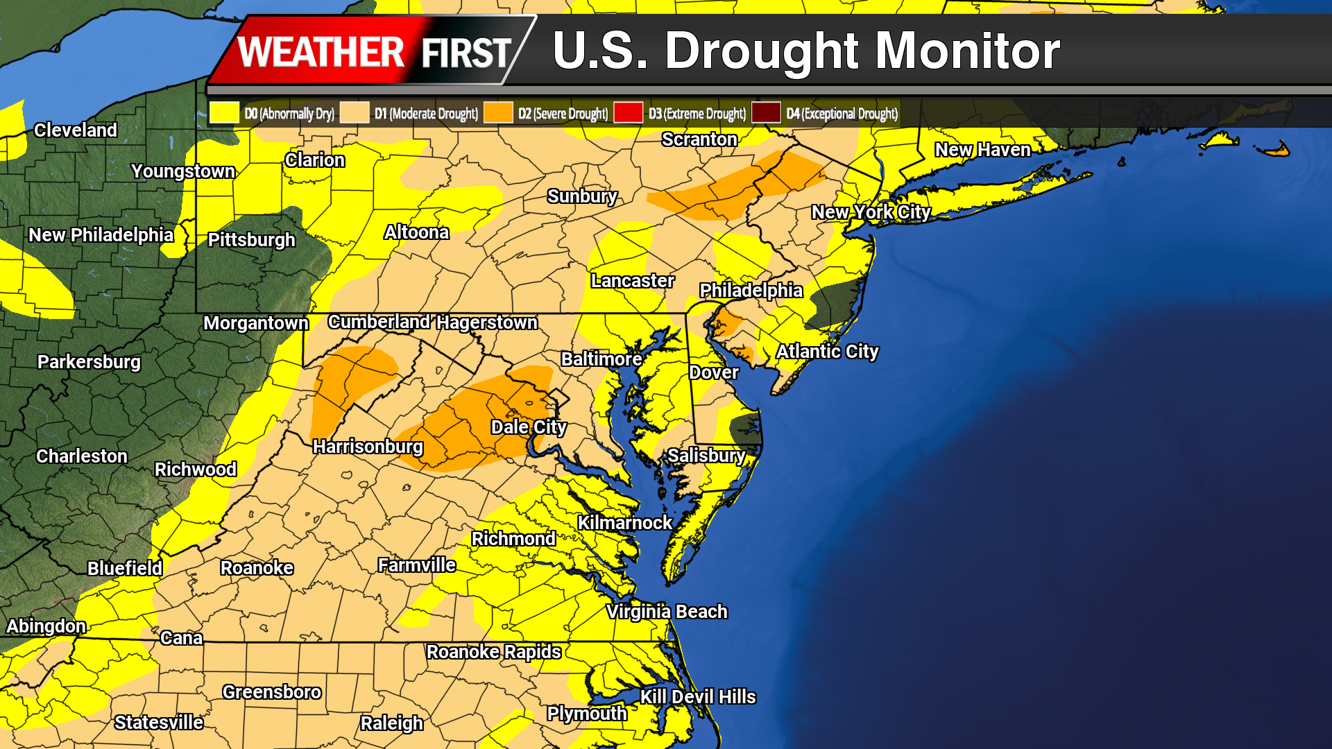
Dry weather has continued to dominate the Delmarva Peninsula, with the latest drought data showing little improvement and increasing stress across the region. While occasional light rainfall has been observed, precipitation totals remain well below normal, providing minimal benefit to soil moisture, groundwater, or streamflows.
Across Delaware, Maryland’s Eastern Shore, and Virginia’s Eastern Shore, ongoing precipitation deficits have allowed abnormally dry to drought conditions to persist and expand. Soils continue to dry, particularly in agricultural areas, and streamflows remain below seasonal averages; clear indicators that the region remains in a developing drought pattern.
In Delaware, short-term dryness is increasingly transitioning into longer-term impacts, with limited recharge of groundwater and growing concerns for water resources if the dry trend continues. On the Maryland Eastern Shore, reduced soil moisture is beginning to affect winter crop establishment and could pose challenges heading into the early spring growing season if meaningful rainfall does not return. Portions of the Virginia Eastern Shore are experiencing similar conditions, with continued low streamflows and dry soils reinforcing drought development.
Looking ahead, forecasters stress that several widespread, soaking rain events will be necessary to slow or reverse drought conditions across Delmarva. Until a wetter pattern develops, drought impacts are expected to persist through the remainder of the year, with close monitoring in place for further degradation.
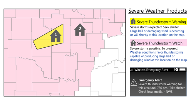
Severe thunderstorms are officially defined as storms that are capable of producing hail that is an inch or larger or wind gusts over 58 mph. Hail this size can damage property such as plants, roofs and vehicles. Wind this strong is able to break off large branches, knock over trees or cause structural damage to trees. Some severe thunderstorms can produce hail larger than softballs or winds over 100 mph, so please pay attention to the weather so you know when severe storms are possible. Thunderstorms also produce tornadoes and dangerous lightning; heavy rain can cause flash flooding.
Do you know the difference between a National Weather Service Severe Thunderstorm Watch and a Severe Thunderstorm Warning? Check your knowledge below.
Severe Thunderstorm Watch: Be Prepared! Severe thunderstorms are possible in and near the watch area. Stay informed and be ready to act if a severe thunderstorm warning is issued. The watch area is typically large, covering numerous counties or even states.
Severe Thunderstorm Warning: Take Action! Severe weather has been reported by spotters or indicated by radar. Warnings indicate imminent danger to life and property. Take shelter in a substantial building. Get out of mobile homes that can blow over in high winds. Warnings typically encompass a much smaller area (around the size of a city or small county) that may be impacted by a large hail or damaging wind identified by an NWS forecaster on radar or by a trained spotter/law enforcement who is watching the storm.
Find out what you can do before severe weather strikes. Preparation is key to staying safe and minimizing impacts.
Be Weather-Ready: Check the forecast regularly to see if you’re at risk for severe weather. Listen to local news or a NOAA Weather Radio to stay informed about severe thunderstorm watches and warnings. Check the Weather-Ready Nation for tips.
Sign Up for Notifications: Know how your community sends warning. Some communities have outdoor sirens. Others depend on media and smart phones to alert residents to severe storms.
Create a Communications Plan: Have a family plan that includes an emergency meeting place and related information. Pick a safe room in your home such as a basement, storm cellar or an interior room on the lowest floor with no windows. Get more ideas for a plan at: https://www.ready.gov/make-a-plan
Practice Your Plan: Conduct a family severe thunderstorm drill regularly so everyone knows what to do if a damaging wind or large hail is approaching. Make sure all members of your family know to go there when severe thunderstorm warnings are issued. Don’t forget pets if time allows.
Prepare Your Home : Keep trees and branches trimmed near your house. If you have time before severe weather hits, secure loose objects, close windows and doors, and move any valuable objects inside or under a sturdy structure.
Help Your Neighbor: Encourage your loved ones to prepare for severe thunderstorms. Take CPR training so you can help if someone is hurt during severe weather.
Find out what you can do when severe weather strikes. Acting quickly is key to staying safe and minimizing impacts.
Stay Weather Ready: Continue to listen to local news or a NOAA Weather Radio to stay updated about severe thunderstorm watches and warnings.
At Your House: Go to your secure location if you hear a severe thunderstorm warning. Damaging wind or large hail may be approaching. Take your pets with you if time allows.
At Your Workplace or School: Stay away from windows if you are in a severe thunderstorm warning and damaging wind or large hail is approaching. Do not go to large open rooms such as cafeterias, gymnasiums or auditoriums.
Outside: Go inside a sturdy building immediately if severe thunderstorms are approaching. Sheds and storage facilities are not safe. Taking shelter under a tree can be deadly. The tree may fall on you. Standing under a tree also put you at a greater risk of getting struck by lightning.
In a Vehicle: Being in a vehicle during severe thunderstorms is safer than being outside; however, drive to closest secure shelter if there is sufficient time.
What should you do when the lightning and thunder stops and it looks likes the severe thunderstorm is over?
Stay Informed: Continue listening to local news or a NOAA Weather Radio to stay updated about severe thunderstorm watches and warnings. More severe thunderstorms could be headed your way.
Contact Your Family and Loved Ones: Let your family and close friends know that you’re okay so they can help spread the word. Text messages or social media are more reliable forms of communication than phone calls.
Assess the Damage: After you are sure the severe weather threat has ended, check your property for damages. When walking through storm damage, wear long pants, a long-sleeved shirt and sturdy shoes. Contact local authorities if you see power lines down. Stay out of damaged buildings. Be aware of insurance scammers if your property has been damaged.
Help Your Neighbor: If you come across people that are injured and you are properly trained, if needed, provide first aid to victims until emergency response team members arrive.
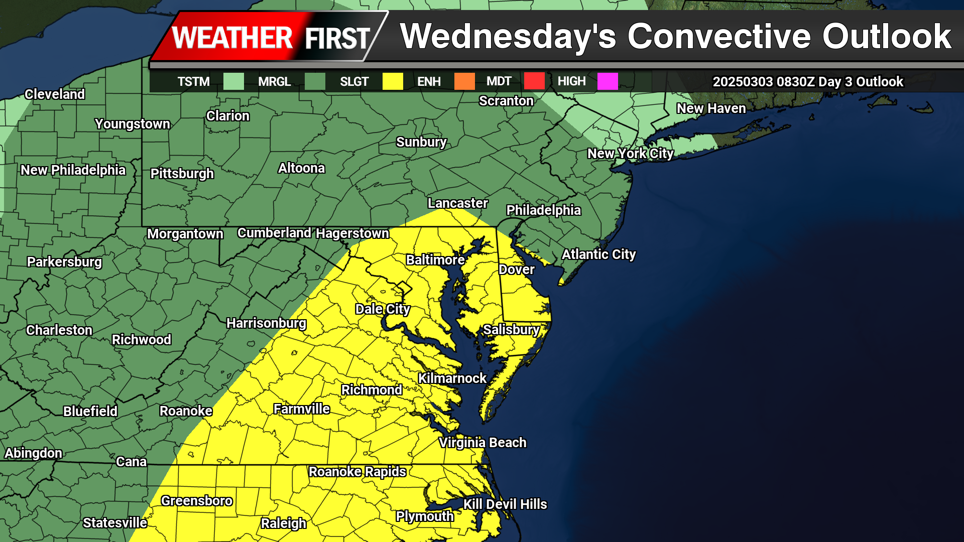
As a powerful storm system begins to develop across the Central Plains, rounds of severe weather are expected from the deep south towards the Mid-Atlantic. As the month turns a new, we are now in Meteorological Spring and the severe weather threats begin showing up across the country.
As a strong area of low pressure lifts up towards the Great Lakes, a tight pressure gradient will create tons of wind energy all over the eastern portions of the United States. On the warm side of the system as a powerful cold front advances eastward, instability and moisture coming from the Gulf will create a line of strong to severe thunderstorms to move through the Mid-Atlantic Wednesday afternoon.
A Slight Risk Of Severe Weather is in place across the Delmarva region down towards areas of the Carolinas. Primary threats will include strong damaging winds and the chance of a isolated tornado can not be ruled out. Storm Prediction Center meteorologist Jeremy Kerr had this to say about the overall threat.
   "Models indicate that surface dew points may increase into the 60s F
   in a corridor across the Carolinas through Virginia during the day.
   Latest NAM forecast soundings suggest that this might occur across
   parts of the Carolina Piedmont into coastal plain prior to the
   arrival of a remnant convective band emerging from the eastern Gulf
   States.  Although lower/mid-tropospheric lapse rates are forecast to
   be rather weak, weak near-surface destabilization might become
   sufficient to support a risk for tornadoes and/or damaging straight
   line wind gusts, given forecast very large, clockwise curved
   low-level hodographs.

   In the wake of this initial band of convection, beneath a developing
   dry slot, northward moisture advection and insolation to the lee of
   the Blue Ridge may contribute to modest destabilization by late
   Wednesday afternoon.  It appears that this will be aided by the
   leading edge of stronger mid-level cooling spreading to the east of
   the Appalachians, and accompanied by increasing thunderstorm
   development in the presence of strong deep-layer shear.  Although
   forecast soundings suggest that low-level hodographs may become more
   modest by this time as the stronger low-level jet core spreads
   offshore, the environment may still become conducive to supercells
   with potential to produce severe wind, hail and perhaps a tornado."
Including the threat for severe weather, high non-thunderstorm wind damage is possible with a strengthening low level jet stream across the region. Model guidance has been showing very strong low level Jetstream winds of 60-80kts at 5000 feet which can be brought down to the surface from heavy rain or thunderstorms.
As of this time, strong winds of 45 upwards to 60 mph are possible as this powerful cold front arrives during the afternoon hours on Wednesday. Winds of this magnitude can bring down trees and powerlines to create sporadic areas of power outages. Winds will continue to be strong after the cold front passes through as the pressure gradient remaining strong through Thursday.
Many of us have been eagerly anticipating relief from the bitter cold, not only for our comfort but also for some respite from the high costs of heating our homes. Over the last 30 days, we’ve experienced one of the coldest stretches in recent years. In fact, this period ranks as the 6th coldest since 1981, with temperatures averaging a remarkable 9 degrees below normal. However, after enduring weeks of frigid conditions, we’re finally seeing the light at the end of the tunnel as January draws to a close and February begins.
The dramatic shift in weather patterns can be attributed to a significant change in the overall Northern Hemisphere setup. The persistent lobe of the Polar Vortex, which has been entrenched over the eastern half of the United States, is finally breaking down. This change is ushering in a new phase, with a deep trough developing across the western United States. As a result, Pacific air is beginning to flow more consistently across the lower 48 states. Here in the East, ridging is starting to take hold, allowing for a warmer southerly flow to bring much-needed relief from the cold.
Now, while we’re not expecting a dramatic swing to extreme warmth akin to the 30-40 degrees below normal temperatures we’ve endured, the return to near-average conditions will be a welcome change. For our region on the Eastern Shore, average temperatures in the mid-40s will feel almost balmy in comparison. In fact, some days may even reach the 50s, which, after this prolonged cold snap, might feel like a veritable heatwave.
Looking ahead to the next 1-2 weeks, the outlook remains promising. Warmer conditions are expected to persist as February gets underway. Beyond that, the latest 3-4 week outlook from the Climate Prediction Center indicates above-average temperatures for much of the Mid-Atlantic and Southeastern United States. While this signals a reprieve from the deep freeze, the question remains: are we done with the cold and snow for the season? Only time will tell, but for now, we can enjoy a much-deserved break from the relentless chill.
*Graphic Provided By The National Weather Service Wakefield, VA*
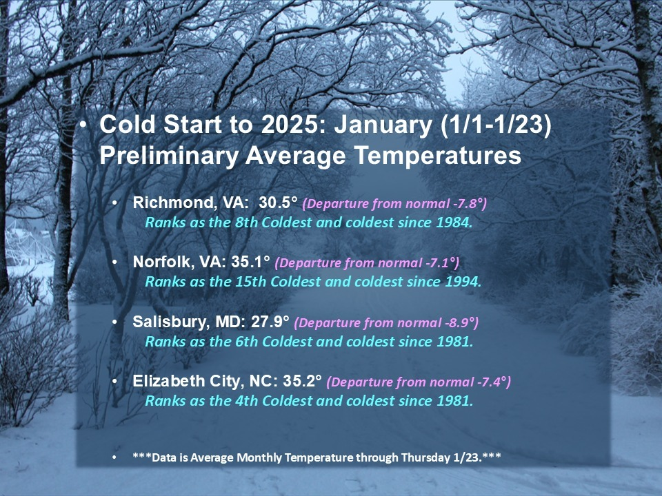
As we examine the climate data for January, we have observed some significant trends. So far this month, average temperatures in our region have consistently been 7 to 9 degrees colder than normal. While this cold weather is not unprecedented, all of our long-term climate monitoring stations are reporting the lowest average temperatures for the first 23 days of January in over 30 years, with certain areas such as Richmond, Salisbury, and Elizabeth City recording their coldest temperatures in over 40 years.
Looking ahead, we anticipate temperatures will begin to stabilize, with averages returning closer to normal levels in the coming week as we near the end of the month. This indicates that while the current temperature deviations are notable, they may decrease somewhat. Nonetheless, we project that Salisbury and Elizabeth City are likely to secure spots on the top 10 coldest January lists by month’s end. Richmond may be on the cusp of making this list, but it is more probable it will fall just outside the top 10. In the meantime, Norfolk, which has a weather record extending over 150 years, is expected to rank between the 15th and 20th coldest January.
Stay warm everyone, and please keep an eye on those temperature fluctuations! #WeatherUpdate #ColdWeather #JanuaryTemperatures #ClimateChange #StayWarm #TemperatureRecord #Meteorology
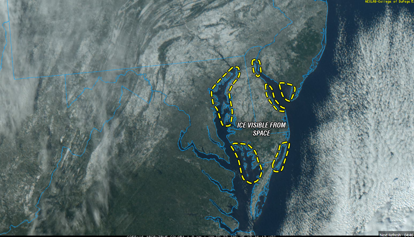
The U.S. Coast Guard has set Winter Port Condition One for the Chesapeake Bay and the Chesapeake & Delaware (C&D) Canal due to increasing ice formation in the region’s waterways. This status indicates that current weather conditions are conducive to further ice development.
Recent observations revealed up to 40% ice coverage, with thicknesses reaching two inches, in areas including the C&D Canal, Welch Point to Nine Foot Knoll, and Turkey Point. Further south, from Quantico to Alexandria, Va., as well as the D.C. Harbor and Anacostia River, ice coverage stands at approximately 30%, with thicknesses around one inch. The Nanticoke and Wicomico rivers report 15% ice coverage at one inch thick.
While no navigation restrictions are currently imposed, the Coast Guard advises mariners to exercise caution. Ice can displace buoys and damage navigational aids, potentially leading to hazards. If ice coverage approaches 100% and impacts port operations, the Coast Guard may initiate icebreaking efforts and implement vessel restrictions.
The Maryland Department of Natural Resources (DNR) and the Coast Guard have icebreaking vessels on standby. Recent icebreaking activities have been reported in sheltered areas, including Selby Bay, South River, and Bay Bridge Marina, to assist vessels hindered by ice accumulation. Continued low temperatures could lead to widespread ice in creeks and along river and bay shorelines, potentially affecting routes such as the Smith Island to Crisfield ferry and oyster harvest operations.
Emergency services are also preparing for icy conditions. The Hacks Point Fire Company conducted ice rescue training at Hack Point Marina on the Bohemia River over the weekend to ensure readiness for potential emergencies.
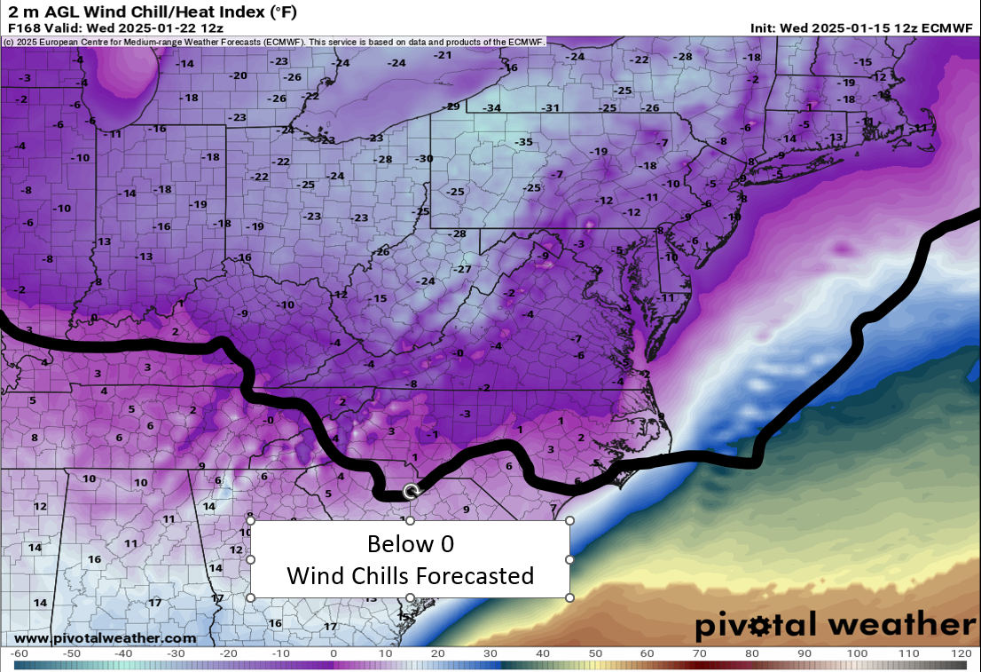
Severe Cold Weather Alert: An Arctic air mass is forecasted to sweep across a significant portion of the United States this weekend! From the Rockies to the Great Plains, this frigid air will reach the Gulf Coast by Saturday night and move towards the Eastern Seaboard by Sunday evening.
Extremely Low Wind Chills: The Rockies, northern Plains, and Upper Midwest are expected to experience dangerous wind chills as low as -30°F or even lower from Saturday through Tuesday. This extreme cold poses serious risks of hypothermia and frostbite for individuals exposed to these conditions. If you plan to travel, ensure you have a cold weather survival kit prepared for your safety.
Furthermore, below-zero wind chills are anticipated to extend into the southern Plains and the Ohio Valley from Sunday night through Tuesday. The hazardous cold is likely to persist along the Gulf Coast and across the Southeast U.S. for much of the following week. Stay warm and take all necessary precautions during this severe cold snap!
Farmers across Delaware are facing severe challenges as a prolonged drought continues to devastate agriculture, leaving crops parched and harvests in jeopardy. With no significant rainfall in the forecast, the risk to both crops and the environment is escalating. In addition to diminished yields, the region is also seeing an increased threat of wildfires, compounding the already dire situation.
The Delmarva Peninsula, known for its fertile soils and agricultural productivity, has been without substantial rain for weeks. As a result, crops are wilting in the fields, and the lack of moisture is taking a toll on growth. Plants rely heavily on soil moisture to absorb nutrients and grow properly, and when water levels drop too low, the stress can stunt development, reduce photosynthesis, and weaken the crops’ overall health. This disruption not only diminishes yields but also leaves plants more vulnerable to disease and pests.
Drought also has significant long-term consequences for soil health. Dry conditions alter soil structure by causing compaction, reducing its ability to absorb and retain water when it finally arrives. The prolonged dryness also impacts the soil microbiome, the beneficial organisms that help break down organic material and maintain fertility. This degradation can persist beyond the drought itself, creating additional challenges for future growing seasons.
Adding to the problem, wildfire risk increases significantly during periods of drought. As vegetation dries out, it becomes highly flammable, creating ideal conditions for fires to ignite and spread. Agricultural areas with dry fields and parched crops are particularly vulnerable. Even small sparks, whether from machinery or natural causes like lightning, can set off fires that spread rapidly, posing a danger not only to crops but also to homes and infrastructure in surrounding areas.
The timing of this drought is especially problematic for Delaware’s farmers, as it coincides with the crucial late-season growing period. Early-season droughts primarily impacted corn crops, but now soybeans, grains, and other key crops are being affected. Cover crops and small grains, typically planted in the fall to protect and rejuvenate soil, are also at risk, as dry conditions hinder germination. Without adequate rainfall, seeds may fail to sprout, leading to wasted efforts and a diminished foundation for next year’s crops.
Furthermore, the inability to plant cover crops threatens long-term soil health. These crops are essential for preventing erosion, improving soil structure, and adding organic matter back into the soil. Without them, soils become more prone to degradation, which can lead to lower productivity in the years ahead.
The compounding effect of back-to-back droughts—one earlier in the season and the current one during this critical growing period—has left farmers struggling to recover. Even if rain comes soon, the damage to crops and soil health may not be fully reversible, as weakened plants and stressed soils may not bounce back entirely.
In addition to the impact on agriculture, the risk of wildfires adds another layer of concern. Dry vegetation combined with warm winds creates the perfect conditions for fires to spread quickly, potentially destroying not just farmland but entire ecosystems. Controlling wildfires in such conditions is difficult, and the damage they cause can be long-lasting, further threatening the region’s environment and economy.
As Delaware’s farmers wait for relief, they face a tough reality: without substantial rainfall soon, the consequences of this drought could stretch well into the future. The effects on crop yields, soil health, and wildfire risks highlight the urgency of addressing drought conditions and their wide-reaching impact on agriculture and the broader environment.
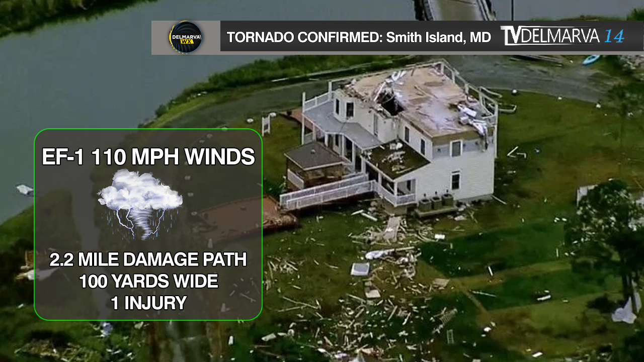
...NWS DAMAGE SURVEY FOR 08/04/22 SMITH ISLAND TORNADO EVENT...

THE FOLLOWING INFORMATION WAS PROVIDED BY LOCAL RESIDENTS AND NEWS
OUTLETS.

RATING:                 EF-1
ESTIMATED PEAK WIND:    110 MPH
PATH LENGTH /STATUTE/:  2.2 MILES
PATH WIDTH /MAXIMUM/:   100 YARDS
FATALITIES:             NONE
INJURIES:               1

START DATE:             AUGUST 4, 2022
START TIME:             7:20 PM EDT
START LOCATION:         SHEEP PEN GUT IN SMITH ISLAND, MD
START LAT/LON:          37.9695 / -76.0467

END DATE:               AUGUST 4, 2022
END TIME:               7:27 PM EDT
END LOCATION:           EWELL IN SMITH ISLAND, MD
END LAT/LON:            38.0000 / -76.0300


A WATERSPOUT TOUCHED DOWN IN THE CHESAPEAKE BAY JUST TO THE
SOUTHWEST OF SMITH ISLAND BEFORE MOVING ASHORE AND CAPSIZING SEVERAL
BOATS LONGER THAN 25 FEET IN SHEEP PEN GUT. AFTER CROSSING SHEEP PEN
GUT, THE TORNADO CROSSED MARSH ROAD JUST TO THE NORTHWEST OF CALVARY
CHURCH, WHERE POWER POLES WERE DOWNED. THE TORNADO TRACKED TO THE
NORTH-NORTHEAST AND REACHED HIGH-END EF-1 INTENSITY WITH ESTIMATED WINDS
OF 110 MPH WHEN IT ARRIVED AT THE INTERSECTION OF MARSH ROAD AND
SMITH ISLAND ROAD. THE TORNADO RIPPED THE ROOF OFF OF ISLAND TIME
BED AND BREAKFAST AND ANOTHER BLOCK BUILDING RIGHT AFTER THIS POINT.
IN ADDITION, A MOBILE HOME JUST NORTH OF THESE TWO BUILDINGS WAS
COMPLETELY DESTROYED AND ONE RESIDENT WAS INJURED. MULTIPLE TREES
WERE DOWNED IN THIS AREA AS WELL. THE TORNADO CONTINUED TO TRACK TO
THE NORTH-NORTHEAST, CROSSING SMITH ISLAND ROAD AND MOVING WELL INTO
THE MARSH EAST OF SMITH ISLAND ROAD. THE TORNADO WEAKENED SOME
BEFORE REACHING THE NORTH SIDE OF THE ISLAND, BUT STILL SEVERELY
DAMAGED AN OUTBUILDING JUST WEST OF THE LOCAL POST OFFICE. IT ALSO
OVERTURNED A GOLF CART, WHICH FELL INTO LEVERING CREEK. THE TORNADO
MOVED BACK INTO THE CHESAPEAKE BAY SHORTLY AFTER CROSSING LEVERING CREEK.

&&

EF SCALE: THE ENHANCED FUJITA SCALE CLASSIFIES TORNADOES INTO THE
FOLLOWING CATEGORIES:

EF0...WEAK......65 TO 85 MPH
EF1...WEAK......86 TO 110 MPH
EF2...STRONG....111 TO 135 MPH
EF3...STRONG....136 TO 165 MPH
EF4...VIOLENT...166 TO 200 MPH
EF5...VIOLENT...>200 MPH

NOTE:
THE INFORMATION IN THIS STATEMENT IS PRELIMINARY AND SUBJECT TO
CHANGE PENDING FINAL REVIEW OF THE EVENT AND PUBLICATION IN NWS
STORM DATA.
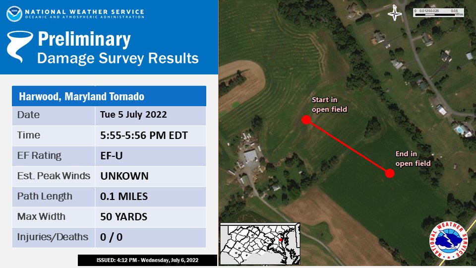
END DATE: JUL 5 2022 END TIME: 556 PM EDT END LOCATION: 1 N HARWOOD MD END LAT/LON: 38.895/-76.597
A SUPERCELL THUNDERSTORM SPAWNED A BRIEF TORNADO JUST NORTH OF HARWOOD, MD (4 SOUTHWEST OF LONDONTOWNE) IN ANNE ARUNDEL COUNTY LATE TUESDAY AFTERNOON JULY 5, 2022, BETWEEN 5:55 AND 5:56 PM EDT.
THIS SUPERCELL ORIGINALLY DEVELOPED ALONG THE HOWARD/MONTGOMERY COUNTY LINE AS A RESULT OF A REMNANT MESOSCALE CONVECTIVE VORTEX (MCV) MOVING THROUGH THE REGION WHICH HAD EARLIER MOVED THROUGH THE OHIO VALLEY EARLIER IN THE DAY. IT EVOLVED INTO A CLUSTER OF CELLS INITIALLY BEFORE SPLITTING OFF INTO AN INDIVIDUAL SUPERCELL THAT WOULD DEVELOP ROTATION AS IT MOVED OUT OF SOUTHEASTERN MONTGOMERY COUNTY INTO NORTHWESTERN PRINCE GEORGES COUNTY. THE CELL DROPPED A TORNADO EARLIER IN THE AFTERNOON NEAR BOWIE, AND WOULD THEN CYCLE TO PRODUCE THE SECOND TORNADO IN HARWOOD.
A BROADCAST MEDIA PARTNER PROVIDED VIDEO AND EYEWITNESS EVIDENCE OF A BRIEF SPIN-UP TORNADO WHILE LOCATED AT THE INTERSECTION OF BIRDSVILLE RD AND SOLOMONS ISLAND RD. THIS INDIVIDUAL NOTED THAT THE TORNADO WAS LOCATED JUST TO THEIR NORTH IN AN OPEN FIELD AND WAS ON THE GROUND FOR ABOUT ONE MINUTE.
KLWX WSR-88D DOPPLER RADAR IN STERLING VA DEPICTED A BRIEF VELOCITY COUPLET THAT CORRESPONDED TO THE LOCATION OF THE VIDEO DESCRIBED ABOVE.
THE BALTIMORE/WASHINGTON WEATHER FORECAST OFFICE IN STERLING, THANKS OUR BROADCATST MEDIA PARTNERS WHO WERE ABLE TO PROVIDE EVIDENCE OF A TORNADO ON THE GROUND.
EF SCALE: THE ENHANCED FUJITA SCALE CLASSIFIES TORNADOES INTO THE FOLLOWING CATEGORIES:
EFU.........UNKNOWN WIND SPEED EF0.........65 TO 85 MPH EF1.........86 TO 110 MPH EF2.........111 TO 135 MPH EF3.........136 TO 165 MPH EF4.........166 TO 200 MPH EF5.........>200 MPH
...NWS Damage Survey for Bowie MD Tornado Event Wednesday
July 5 2022...

Rating: EF1
Estimated Peak Wind: 90 mph
Path Length: 1.0 mile
Path Width: 125 yards
Fatalities: 0
Injuries: 0

Start Date: Jul 5 2022
Start Time: 531 PM EDT
Start Location: 1 NW Bowie MD
Start Lat/Lon: 38.9710/-76.7470

End Date: Jun 5 2022
End Time: 534 PM EDT
End Location: 1 NE Bowie MD
End Lat/Lon: 38.9697/-76.7281

A supercell thunderstorm spawned a brief EF0 tornado just north
of Bowie, MD in Prince Georges County late on Wednesday afternoon
July 5 2022 between 5:31 and 5:34 PM EDT. This supercell spawned
along the Howard/Montgomery County line as a result of a remnant
mesoscale convective vortex moving through the region which had
moved through the Ohio Valley earlier in the day. It evolved into
a cluster of cells initially before splitting off into an
individual supercell that would develop rotation as it moved out
of southeastern Montgomery County into northwestern Prince Georges
County.

The tornado caused extensive tree damage in the Somerset
subdivision just north of Bowie, MD. There was also once incidence
where a tree had fallen on top of residence on Stafford Ln. The
most concentrated areas of damage occurred between Stafford Ln.
and Saber Ln. However, there were several other trees down in the
area outside of the more concentrated tornadic damage,
particularly along Buckingham Drive perpendicular to White Marsh
Branch. At this location along Buckingham Drive, trees fell upon
power lines, snapping several supporting utility poles.

The tornado initially touched down around Tarragon Ln. and tracked
eastward over the Bowie High School Annex before tracking into the
Somerset subdivision, where the majority of the damage was
observed. The tornado would then lift just before reaching
southern portions of Whitemarsh Park.

KLWX WSR-88D Doppler Radar in Sterling VA depicted a tight
velocity couplet that corresponded to the location of the damage
described above. Residents in the area noted that they received
the wireless emergency alert disseminating the Tornado Warning
issued by the National Weather Service Baltimore/Washington
Weather Forecast Office prior to the damage occurring, and took
appropriate action to reduce their risk of injury from the
tornado.

The Baltimore/Washington Weather Forecast Office in Sterling,
thanks the City of Bowie and the Prince Georges County Department
of Emergency Services for their assistance in this survey, along
with the residents of Prince Georges County that were witness to
this tornado event.

EF Scale: The Enhanced Fujita Scale classifies tornadoes into the
following categories:

EF0.........65 to 85 mph
EF1.........86 to 110 mph
EF2.........111 to 135 mph
EF3.........136 to 165 mph
EF4.........166 to 200 mph
EF5.........>200 mph
If you’re at the beach this week, a good chance you will see a giant floating shark in the sky!
.
The East Shark blimp is in our area to promote Shark Week on the Discover Channel, starting July 24. The 128-foot long blimp is scheduled to travel along the east coast until July 30, where it is competing against a West Coast blimp just like with with a hashtag social media battle.
.
The blimp was in Bethany Beach, Fenwick Island and Ocean City, Maryland yesterday for the 4th of July. It is scheduled to be in Ocean City today and will make a return to the area on July 24, and Ocean City once again on July 25.
.
Currently, East Coast Shark is beating West Coast Shark. You can share your shark blimp sightings with the hashtag #eastcoastshark.
Ocean City (Maryland) Police are investigating a triple stabbing that occurred last night (June 20).
Officers were called to the 10-block of Wicomico Street on the boardwalk for a reported fight just before midnight. When officers arrived, three victims suffered stab wounds. Ocean City Fire and emergency crews also responded to the scene.
One of the victims was flown to Shock Trauma, while another was flown to Christiana Hospital. Another victim was transported to TidalHealth Peninsula Regional. Their conditions are unknown at this time.
Ocean City Police continue to investigating the incident.
Officer Glenn Hilliard (Wicomico County Sheriff’s Office)
The Wicomico County Sheriff’s Office is mourning the loss of one of their deputies this morning after attempting to apprehend a fugitive in nearby Pittsville, Maryland on Sunday.
Deputy First Class Glenn Hilliard, a 16-year veteran on the force, was gunned down while while attempting to apprehend a suspect who was wanted for several felony warrants. The suspect, identified as Austin Davidson, fled the scene. After an extensive manhunt, the suspect was apprehended.
“The days ahead will be challenging, but for now, we are mourning the loss of an incredible human being. Deputy Glenn Hilliard was a son, a husband and a father to three beautiful children, a brother to those he worked with, and an exemplary public servant to the citizens of Wicomico County and to the State of Maryland” The Wicomico County Sheriff’s Office says in a statement. “Our hearts and prayers go out to Glenn’s family during this difficult time.”
Officer Hilliard would have celebrated his 42nd birthday on June 22. The sheriff’s office say they are heartbroken over his “senseless and tragic murder”.
Delaware Governor John Carney and Maryland Governor Larry Hogan made a friendly March Madness wager ahead of tonight’s matchup between the No. 4 seed University of Maryland Terrapins and the No. 13 seed University of Delaware Fightin’ Blue Hens in the first round of the 2022 Women’s NCAA Tournament.
Both governors wagered crab cakes from their respective states.
“Delaware is known for being the First State, and for our incredible beaches and delicious food—like the famous crab cakes at Woody’s in Dewey Beach,” said Governor Carney. “We’re really proud of our Fightin’ Blue Hens, and look forward to their success in the tournament. Thank you to Governor Hogan for this fun challenge, and for preparing some crab cakes to send over to Delaware. Let’s go, Blue Hens!”
“Crab cakes and basketball—that’s what Maryland does,” said Governor Hogan. “Our women’s basketball program is one of the best in the nation, and I’m confident that tomorrow’s game will be a slam dunk for our Terps. I want to thank Governor Carney for agreeing to this friendly wager, and I look forward to trying some inferior Delaware crab cakes after the big win.”
The Blue Hens, led by Coach Natasha Adair, are 24-7 this season.
The Terps, led by Coach Brenda Frese, are 21-8. Tip off is tonight at 5 p.m. at Xfinity Center in College Park.
We are not finished with the snow just yet. With a decent snow cover still on the ground to this date, more will be added beginning tomorrow night into the morning hours on Friday. This should not be a significant event like we saw on Monday, but enough to cause some roadway problems going into the Friday morning rush hour.
Risk Analysis Regarding Snow & Travel Over The Next 3 Days
With light to moderate accumulations on the table, there will be an area of sleet especially near Salisbury, Ocean City, and the Pocomoke City regions where temperatures will be flirting with the 32 degree mark. Locations further north will start out between 32 and 34 degrees before dropping down below freezing, once the precipitation arrives. Another instance of Dynamic Cooling will take place. This will be fairly wet snow just like last time, and it should not have a problem sticking to roadways.


 Severe Cold Weather Alert: An Arctic air mass is forecasted to sweep across a significant portion of the United States this weekend!
  From the Rockies to the Great Plains, this frigid air will reach the Gulf Coast by Saturday night and move towards the Eastern Seaboard by Sunday evening.
 Extremely Low Wind Chills: The Rockies, northern Plains, and Upper Midwest are expected to experience dangerous wind chills as low as -30°F or even lower from Saturday through Tuesday. This extreme cold poses serious risks of hypothermia and frostbite for individuals exposed to these conditions. If you plan to travel, ensure you have a cold weather survival kit prepared for your safety.
 Furthermore, below-zero wind chills are anticipated to extend into the southern Plains and the Ohio Valley from Sunday night through Tuesday. The hazardous cold is likely to persist along the Gulf Coast and across the Southeast U.S. for much of the following week. Stay warm and take all necessary precautions during this severe cold snap!