Tag: ice

  • Unsettled Weekend Weather Ahead; Coastal Storm Threat Diminishing

    Unsettled Weekend Weather Ahead; Coastal Storm Threat Diminishing

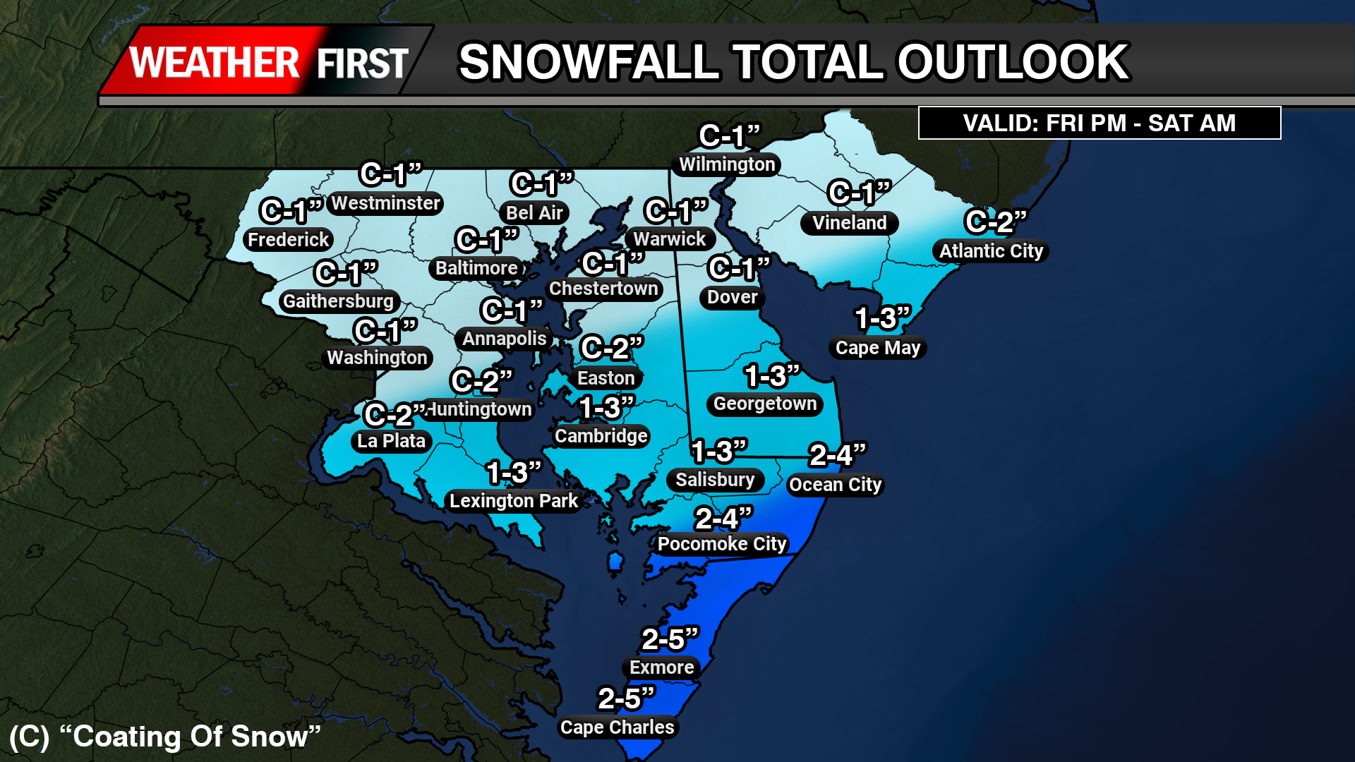
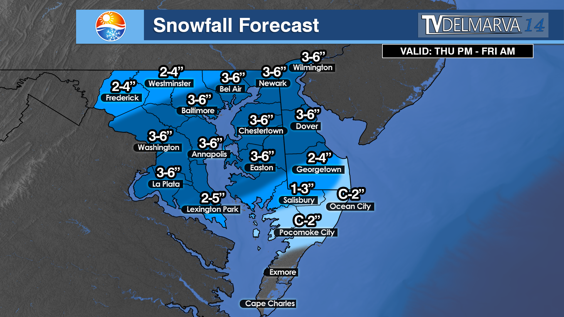
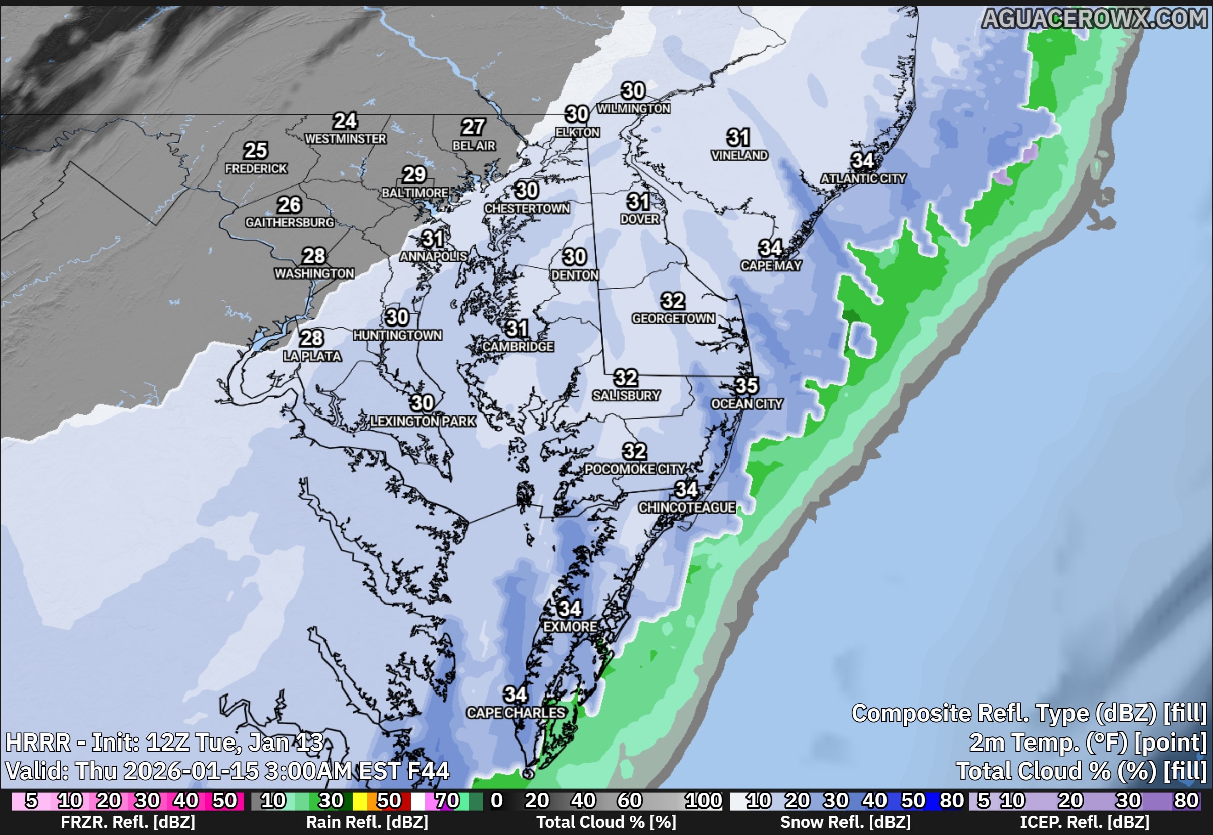
    A developing storm system will bring a period of light snow early Saturday morning before transitioning to rain for many locations as the day goes on. The highest chances for accumulating snow will be found near and northwest of the Interstate 95 corridor, with the greatest totals expected farther north.

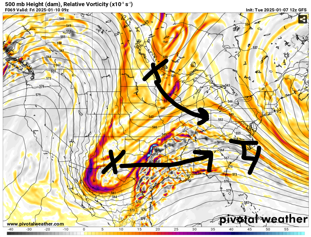
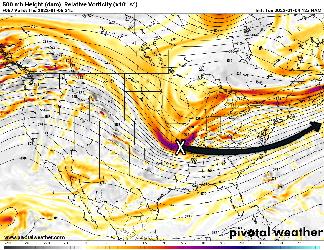
    An upper level trough will be positioned over the eastern United States this weekend, allowing several smaller disturbances to move through the region. The first of these systems is expected to arrive during the pre dawn hours on Saturday. As it moves in, increasing lift in the atmosphere and a gradual influx of milder air aloft will help precipitation develop.

    Forecast guidance now suggests the system will be slightly more organized than previously expected. As a result, rainfall totals have increased modestly. Areas near and northwest of I 95 are expected to receive between one tenth and two tenths of an inch of liquid precipitation through Saturday, while locations southeast of I 95 are likely to remain under one tenth of an inch.

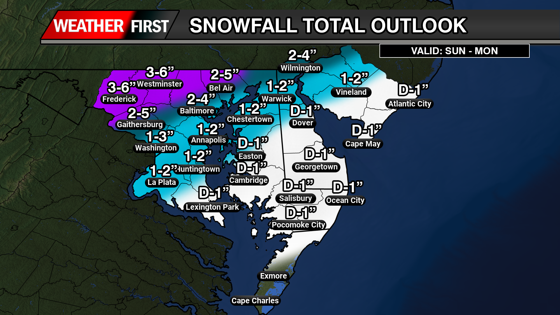
    Precipitation is expected to begin mainly as snow early Saturday before gradually changing to rain from southeast to northwest. Little to no snow accumulation is expected southeast of the I 95 corridor before the transition occurs. Near and just northwest of I 95, snowfall amounts should range from a light dusting up to one inch.

    Farther north, including the Lehigh Valley, northwest New Jersey, and the southern Poconos, colder air will allow snow to persist longer. In these areas, snowfall totals are now forecast to reach one to two inches, with up to three inches possible at higher elevations in the southern Poconos where rain mixing may be limited.

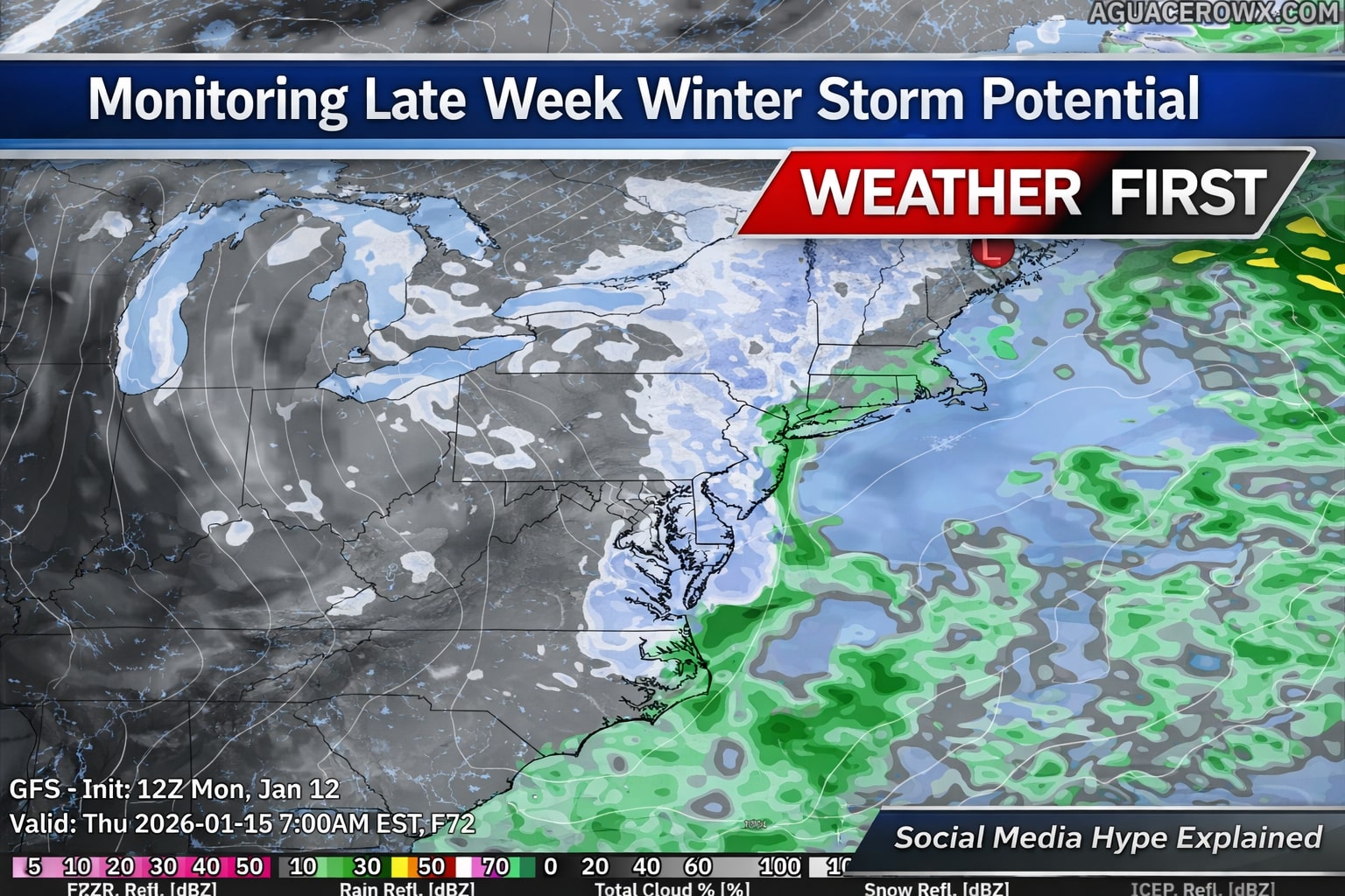
    Watching a Coastal System for Sunday

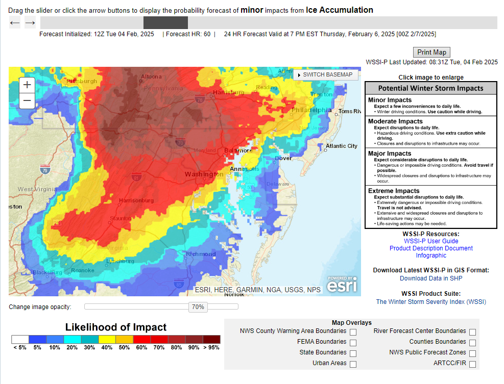
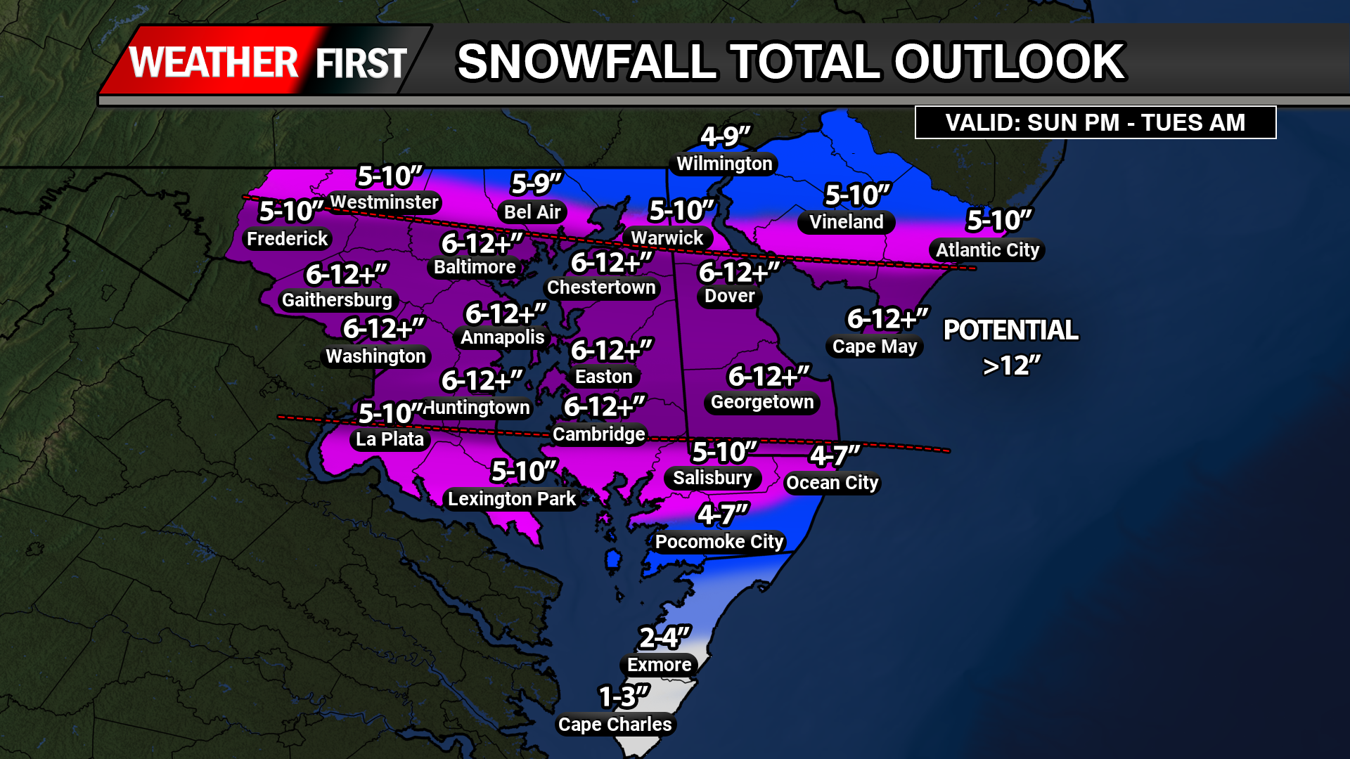
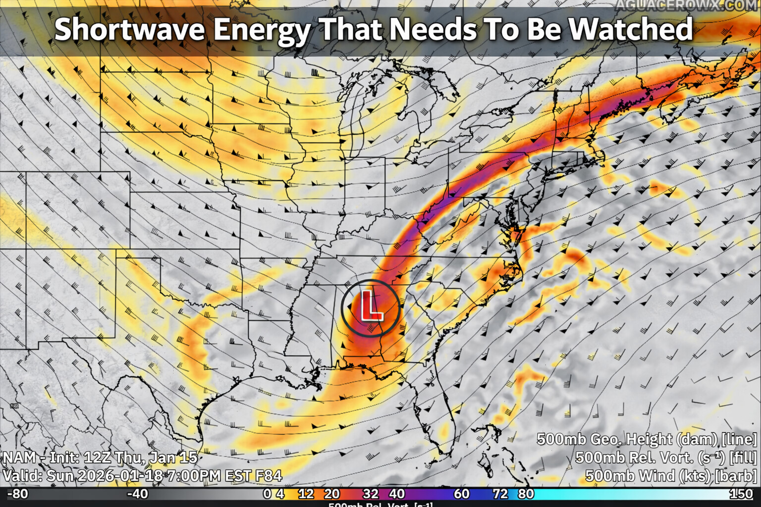
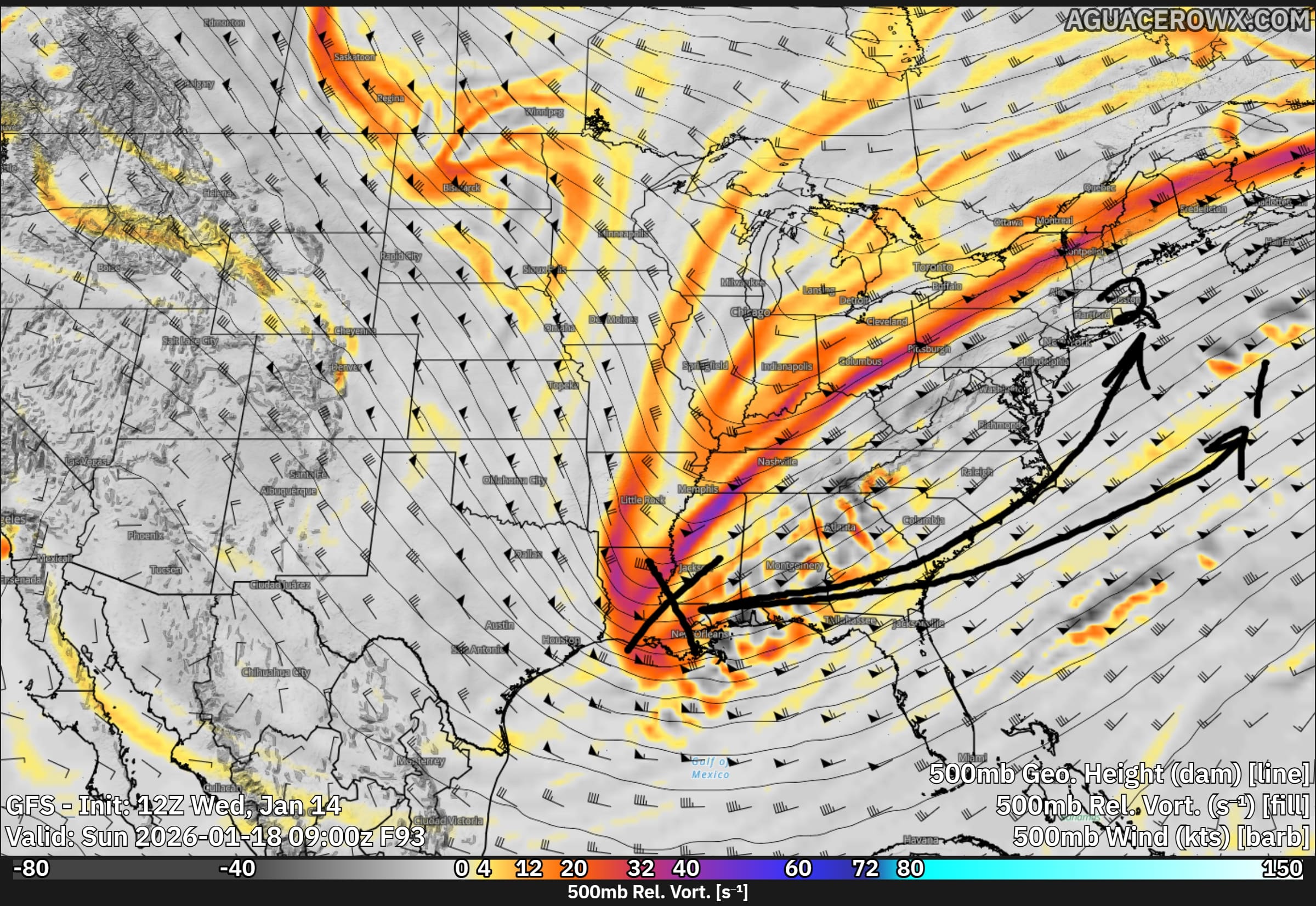
    Attention then turns to a separate storm system expected to develop offshore late in the weekend. This coastal low is forecast to form near the Outer Banks and track northeastward on Sunday. At this time, the overall threat for a significant snowfall remains low.

    Most forecast models continue to favor a track well offshore, which would limit impacts across the region. Under the current forecast, light snow is possible along the coast and areas south and east of I 95 on Sunday, while locations farther inland may see little or no accumulation.

    There is still some uncertainty, as a small number of ensemble models suggest a closer track could occur. However, confidence in that scenario remains low. Probabilities for advisory level snowfall remain modest, generally around 20 to 25 percent at the immediate coast, decreasing farther inland.

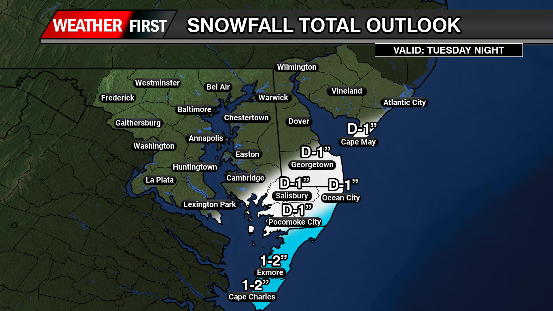
    Current snowfall forecasts call for around one half inch to one and a half inches along the coast and southern Delaware, with a coating to one inch possible up to the I 95 corridor. North and west of I 95, only a few flurries or trace amounts are expected.

    Any precipitation associated with this system is expected to taper off Sunday night as the storm pulls farther offshore.

  • Unsettled Weekend Weather Possible Across Delmarva As Coastal System Develops With Snow Threat

    Unsettled Weekend Weather Possible Across Delmarva As Coastal System Develops With Snow Threat

    Residents across the Delmarva region will want to stay weather aware this weekend as multiple rounds of precipitation are possible, including the potential for snow. Forecast confidence remains moderate to low, but the overall pattern supports unsettled conditions from Saturday through Sunday night.

    A broad area of low pressure aloft, known as a longwave trough, will settle over the eastern United States this weekend. Several smaller disturbances moving through this pattern will help generate periods of precipitation, beginning early Saturday and possibly continuing into Sunday night.

    The first system is expected to move through Saturday morning and appears to be relatively weak. Precipitation may begin near or shortly after daybreak, when temperatures are at their coldest. Some locations could see a brief mix or light snow at the onset, especially inland areas, before temperatures rise through the morning. As daytime heating and weak warm air move in, most of Delmarva should transition to light rain. Any snow accumulation during this first round is expected to be minimal, with little more than a trace for most areas. Overall precipitation amounts should remain under a tenth of an inch.

    Attention then turns to a second system that could develop offshore late Sunday into Sunday night. This system carries more uncertainty and higher potential impacts, depending largely on how close the surface low tracks to the coast. Recent forecast guidance has shown a slight shift toward a closer approach, which has increased the chance for precipitation across the region, especially near coastal areas.

    With a cold front moving through Saturday night, colder air will be in place on Sunday. If the offshore low tracks close enough, much of the precipitation could fall as snow, particularly during the latter half of Sunday and into Sunday night. At this time, the probability of seeing measurable snow across coastal Delmarva is around 35 to 50 percent (of greater than 1″), with lower chances farther inland. The likelihood of higher snowfall amounts remains low, but it cannot be ruled out if the storm trends closer to the coast.

    While confidence has increased slightly compared to earlier forecasts, there is still considerable uncertainty regarding the exact track and strength of this system. Residents across Delmarva should continue to monitor the forecast through the weekend, as small changes in storm position could significantly impact precipitation type and amounts.

    More updates will be provided as forecast confidence improves.

  • Will It Storm Or Will It Be Another Dud? The Talk About Sun-Mon Storm Signal

    Will It Storm Or Will It Be Another Dud? The Talk About Sun-Mon Storm Signal

    We are gearing up to be in a fairly hostile pattern with many pieces of energy to play with here over the next 2 weeks as a large long wave trough sits over the eastern US. The biggest issue right now is do they interact with each other or will they remain strung out wasting the potential for snow lovers out there.

    While the overall risk of impactful wintry weather remains low heading into early next week, colder temperatures mean even small changes in the forecast could introduce a chance for snow.

    A brief warm up to near seasonal levels is expected Saturday ahead of a passing cold front. Behind it, a colder pattern looks likely to settle back in and persist through at least the middle of next week, with temperatures running below normal. During this time, several weak disturbances are forecast to move through the region. While none of these systems appear particularly strong on their own, there is a possibility they could interact in a way that brings a wintry weather threat late Sunday into Monday.

    At this time, the most likely outcome would be flurries or light snow, with limited or no accumulation. However, if the shortwave has more of a interaction with the Jetstream, that can bring larger impacts. Forecast confidence remains low, with precipitation chances generally in the 20 to 30 percent range.

    Given the cold air in place, this period will need to be monitored closely for any changes that could increase the wintry weather threat. For now, the risk of a significant winter storm from Sunday into early next week remains low, but not zero.

  • Flash Freeze Risk Thursday Morning as Arctic Front Sweeps Through

    Flash Freeze Risk Thursday Morning as Arctic Front Sweeps Through

    A rapidly moving arctic cold front will create dangerous flash freezing conditions early Thursday morning, posing a significant hazard for travel across the region.

    Temperatures are expected to fall sharply from the 50s into the 20s in just a few hours as the front passes. Rain will transition to snow during this time, but the most serious concern will be the sudden freeze of wet roadways, sidewalks, and bridges.

    As colder air rushes in behind the front, any standing water from earlier rainfall will freeze almost instantly. This can lead to a thin but extremely slippery layer of ice forming with little to no warning. Bridges, overpasses, untreated roads, and shaded areas will be especially vulnerable to rapid icing.

    The timing of the temperature drop may coincide with the Thursday morning commute, increasing the risk for accidents and hazardous travel conditions. Even areas that see minimal snowfall could experience dangerous conditions due to ice forming faster than road crews can treat surfaces.

    Gusty winds behind the front will reinforce the cold air and cause wind chills to drop quickly, making conditions feel even colder by daybreak. Any snow that does fall will be brief, but it may further reduce visibility during the transition.

    Residents are urged to use caution if traveling early Thursday morning. Slowing down, allowing extra stopping distance, and remaining alert for icy patches will be critical. If possible, delaying travel until conditions improve later in the morning is strongly advised.

    Conditions are expected to stabilize later Thursday as precipitation ends, but cold temperatures will persist through the day.

  • Wintry Mix Followed By Arctic Cold To Finish Work Week

    Wintry Mix Followed By Arctic Cold To Finish Work Week

    A developing storm system will bring a brief period of light rain to Delmarva late Wednesday, with the potential for a few snowflakes before the precipitation ends early Thursday. While impacts from precipitation look minimal, the bigger story will be the sharp drop in temperatures and strong winds that follow and last into Friday.

    On Wednesday, a cold front associated with a passing system to our north will move through the region. This front will help produce a shield of light precipitation across the area Wednesday afternoon and evening. With temperatures starting off mild, most locations on Delmarva will see rain initially. As colder air moves in overnight, rain could briefly mix with or change to snow before ending early Thursday morning. Any snow accumulation is expected to be very light, with little to no impact expected across Delmarva.

    A secondary storm system is expected to develop offshore along the Carolina coast late Wednesday night into Thursday. Current forecast guidance keeps this system well offshore, meaning it should have little to no effect on our region. Because of this, confidence remains high that Thursday will be largely dry, aside from a small chance of lingering light precipitation early in the morning.

    Temperatures will be relatively mild ahead of the front on Wednesday, with highs ranging from the mid 40s to near 50 degrees across Delmarva. Conditions will change quickly Wednesday night as colder air pours into the region. By Thursday morning, temperatures will drop into the mid 20s to near 30 degrees. Strong west to northwest winds will develop, creating wind chills in the teens and lower 20s through much of the day.

    Thursday will feel bitterly cold and blustery, with sustained winds of 15 to 25 mph and gusts occasionally reaching 30 to 35 mph. Afternoon temperatures will struggle to recover, only reaching the upper 20s to mid 30s despite some sunshine.

    The coldest air arrives Thursday night into early Friday. Overnight lows will fall into the teens and lower 20s across Delmarva, and persistent winds will push wind chills into the single digits by Friday morning. Friday remains cold, with highs once again in the upper 20s to mid 30s and wind chills staying in the lower to mid 20s.

    While this system will not bring significant precipitation, the combination of strong winds and sharply colder temperatures will make it feel more like mid winter across Delmarva heading into the end of the week.

  • Winter Uncertainty Towards The Late Week; Social Media Hype Is Crazy Right Now

    Winter Uncertainty Towards The Late Week; Social Media Hype Is Crazy Right Now

    Forecast guidance continues to signal the potential for a disruptive winter weather pattern later this week, mainly from Wednesday through Friday, as an upper level low strengthens over the Lower Great Lakes and moves toward the Northeast. This system is expected to bring an increase in wintry precipitation across parts of the Lower Great Lakes, the central Appalachians, and portions of the interior Northeast, with colder air also setting the stage for lake effect snow in typical snowbelt regions.

    However, confidence in the overall setup remains low. Key details such as the exact placement and strength of the upper level low are still uncertain, which will ultimately determine where the heaviest precipitation develops. There is also considerable question surrounding coastal low development, including whether it forms too late, remains weak, or tracks well offshore. Recent trends as of today favor a later developing system that stays farther out to sea, which would significantly limit impacts for much of the I-95 corridor.

    The primary question for Delmarva centers on whether a coastal low is able to develop in time and close enough to influence the region. Current guidance shows large spread in both timing and track, with recent trends favoring a system that forms too late and remains well offshore. If this trend holds, meaningful winter weather impacts across Delaware, eastern Maryland, and Virginia’s Eastern Shore would be limited or possibly avoided altogether.

    Because of these uncertainties, forecast impacts to travel and infrastructure remain unclear at this time. While some wintry weather is possible inland, especially across higher elevations and areas closer to the Great Lakes, any coastal impacts would depend on how quickly and how close a coastal low can organize. Forecast confidence should improve over the next few days as the system comes into better range of higher resolution models.

  • Icy Post Christmas Storm Across The Northern Mid-Atlantic States

    Icy Post Christmas Storm Across The Northern Mid-Atlantic States

    A significant post-Christmas winter storm is expected to create hazardous conditions from the Great Lakes through the Mid-Atlantic and into the Northeast through Saturday morning, bringing a complex mix of snow, sleet, and freezing rain that will heavily impact travel and infrastructure across the region.

    According to the Weather Prediction Center, this is a multi-hazard winter storm, with the most dangerous impacts tied to ice accumulation and heavy snowfall. A swath of heavy snow is forecast from central New York into southern New England, including portions of northeastern Pennsylvania and the New York City metro area. Many of these locations could see six inches or more of snow, with snowfall rates exceeding one inch per hour at times, leading to rapidly deteriorating road conditions.

    Farther south, the primary concern shifts from snow to ice. Freezing rain and sleet are expected to dominate across portions of Pennsylvania, western and central Maryland, and parts of the Mid-Atlantic, creating a dangerous glaze on untreated surfaces. Ice accumulations over a quarter inch are possible in some areas, increasing the risk for tree damage and scattered power outages.

    Northern Maryland Impacts

    Northern Maryland, including areas near and north of the Baltimore metro, is expected to be near the transition zone between snow and freezing rain. This setup raises the risk for significant sleet accumulation followed by freezing rain, which can be particularly hazardous for travel. Roads may quickly become icy, even where surface temperatures hover near freezing. Elevated surfaces such as bridges and overpasses will be especially prone to icing. Any ice buildup on trees and power lines could result in localized outages and downed limbs.

    Northern Delmarva Concerns

    Across northern Delmarva, including Cecil County, Kent County, and areas near the upper Chesapeake Bay, a wintry mix of sleet and freezing rain is expected to develop, particularly late Friday into Friday night. While snowfall totals are likely limited, even light ice accretion could significantly impact travel along major corridors such as I-95, U.S. Route 13, and local secondary roads. Gusty winds combined with ice may further stress trees and utility lines, increasing the risk of isolated power disruptions.

    Travel and Safety Impacts

    The timing of this storm is particularly concerning, as it coincides with post-Christmas travel. Treacherous road conditions are expected to persist into Saturday morning, especially in areas affected by freezing rain and sleet. Visibility reductions, slick surfaces, and rapidly changing precipitation types will make driving dangerous, even for experienced winter drivers.

    Residents across northern Maryland and northern Delmarva are urged to closely monitor forecast updates, avoid unnecessary travel during periods of freezing rain, and prepare for the possibility of power outages. This storm serves as a reminder that ice, even more than snow, can quickly escalate impacts and disrupt daily life across the Mid-Atlantic.

  • An Icy Boxing Day On The Way For The Mid-Atlantic States

    An Icy Boxing Day On The Way For The Mid-Atlantic States

    Its shaping up to be a fairly icy day after Christmas for many across the Mid-Atlantic states Friday into Saturday. A classic “Overrunning Event” to unfold as a warm front moves into arctic air that’s trapped across New England forced by northeast winds ahead of the precip.

    An overrunning event in winter meteorology occurs when warm, moist air is lifted up and over a shallow layer of cold air at the surface. This setup is common ahead of winter storms and often develops north of a warm front. Because cold air is denser, it remains trapped near the ground while warmer air flows over it along sloping isentropic surfaces.

    As the rising warm air cools, clouds and precipitation develop well in advance of the main storm system. In winter, this frequently leads to widespread, long-duration precipitation, often falling as snow, sleet, or freezing rain, depending on the temperature profile of the atmosphere. Overrunning events are typically associated with stratiform precipitation, lower visibility, and steady rather than convective rainfall or snowfall.

    These events can produce significant winter weather impacts, including heavy snow accumulations, ice accretion, and hazardous travel conditions, especially when cold air is reinforced at the surface by high pressure to the north. Overrunning precipitation often marks the initial phase of a winter storm before stronger dynamics and surface low pressure move in.

    With the latest guidance at this time, areas closer towards the Mason-Dixon have the greatest threat for looking at snow and ice accumulations as the cold air will be locked up better in those regions. totals wise at this time is not for certain the amount of snow/ice is expected with this system as we get a bit closer in time. Areas across Central Delmarva will start off with that wintry mix but eventually change over to plain rain as the winds turn a bit more easterly which will bring in that warmer Atlantic air across the region.

  • UPDATED: Accumulating Snowfall Expected Late Tonight; Bitter Arctic Air To Follow

    UPDATED: Accumulating Snowfall Expected Late Tonight; Bitter Arctic Air To Follow

    Another round of accumulating snowfall is on tap for this weekend during the early morning hours Sunday through the late morning hours. Overall snowfall amounts have increased across Central and Northern Delmarva for tonight. A Clipper system approaching from the Mid-west will begin to redevelop a coastal low will bring a band of light to moderate snowfall to the region on Sunday as an arctic frontal boundary moves through bring severely cold temperatures throughout the Eastern US.

    Looks like right now areas across Northern Maryland, Northern Delmarva, and South Jersey will be in the hot seat for seeing the most accumulating snow when the coastal low begins to take over. A widespread swaft of 3-6 inches of snow is likely with areas further south will have lighter precipitation to deal with overall. Making for Sunday morning travel a bit slick with temperatures in the upper 20s to lower 30s and the winds begin to pick up later in the day for some blowing and drifting.

    An Arctic air mass is moving southward, bringing dangerously low temperatures and life-threatening wind chills across a broad swath of the central US, from the Northern Plains towards the Mid-Atlantic

    Temperatures are forecasted to plunge 20 to 30 degrees below normal, with wind chills dropping below -30°F in some areas. This extreme cold poses serious risks to human health, pets, and infrastructure, including the potential for frozen pipes.

    Residents in the affected regions are urged to prepare immediately by taking steps to protect themselves, their animals, and their homes. The agencies emphasize the importance of readiness to mitigate the harsh impacts of this severe weather event.

  • Significant Winter Storm Set to Impact the Delmarva Region Tuesday into Wednesday

    Significant Winter Storm Set to Impact the Delmarva Region Tuesday into Wednesday

    Another winter storm is set to impact the region as we move into Tuesday and Wednesday, bringing a mix of heavy snow, ice, and rain across the Delmarva Peninsula. Snow and wintry precipitation will begin Tuesday afternoon and continue through Wednesday morning, leading to widespread travel disruptions and hazardous conditions.

    This storm is developing as a new area of low pressure forms over the Deep South and tracks northeastward along a stalled frontal boundary. At the same time, a strong high-pressure system to the north will funnel cold air into the region, setting the stage for a classic overrunning event. In this setup, warm, moisture-laden air from the Gulf of Mexico moves over the dense, cold Arctic air advancing southward from Canada, creating widespread heavy snowfall from the Midwest into the Mid-Atlantic. This process, known in meteorology as isentropic ascent, drives the formation of clouds and precipitation as the warm air rises and cools.

    In a winter storm overrunning setup, isentropic ascent occurs when warm, moist air is forced to rise over a cold, dense air mass at the surface. This typically happens along a stationary front or warm front, where the warm air follows sloping isentropic surfaces (constant potential temperature). As the air rises, it cools adiabatically, leading to cloud formation and precipitation.

    Since winter storms involve subfreezing surface temperatures, this precipitation can fall as snow, sleet, or freezing rain, depending on the temperature profile. Stronger isentropic ascent enhances moisture transport and lift, leading to heavier and more widespread winter precipitation.

    Snowfall Potential and Accumulation Estimates

    The latest ensemble model guidance indicates a significant increase in snowfall probabilities across central and northern Delmarva. There is now a 60-90% chance of at least 3 inches of snow north of the Maryland-Delaware state line, with 40-60% probabilities for accumulations exceeding 6 inches from Delmar, DE to Smyrna, DE.

    The heaviest snowfall totals are expected between the MD/DE line and Smyrna, where an average of 4 to 8 inches is forecast. This extends westward toward Washington, D.C.. However, localized snow bands could produce isolated totals up to 10 inches, particularly across central Delmarva.

    Coastal and Southern Delmarva Impacts

    Further south, near the coastal areas including Berlin and Pocomoke City, the storm will begin as snow but may transition to a mix of snow, sleet, and rain as temperatures rise above freezing. This will reduce overall snowfall totals due to melting overnight Tuesday into early Wednesday.

    Meanwhile, areas further north will remain all snow, though the intensity may be slightly lower compared to central Delmarva. Regardless, this storm is shaping up to be a significant winter weather event across the region, bringing hazardous travel conditions and potential disruptions.

    Stay tuned for updates as forecast details continue to evolve.

  • Wintry Mix Threatens Central and Northern Delmarva Again with Ice Accretion and Slick Travel This Weekend

    Wintry Mix Threatens Central and Northern Delmarva Again with Ice Accretion and Slick Travel This Weekend

    A complex winter weather system is set to impact portions of central and northern Delmarva, bringing a mix of snow, sleet, and freezing rain as temperatures hover near the freezing mark towards early Saturday afternoon. This system will create hazardous travel conditions, especially in areas where freezing rain leads to ice accretion.

    Weather Setup and Model Guidance

    Latest guidance from the ICON, GFS, and ECMWF suggests that cold air at the surface will remain entrenched across northern Delmarva, allowing for a prolonged period of wintry precipitation before a gradual changeover to rain. Meanwhile, high-resolution CAMS guidance, including the HRW-WRF & NAM12KM, continues to highlight higher localized areas of ice accumulation, particularly in northern regions where cold air remains stubborn.

    As the system moves through, precipitation is expected to start as a wintry mix of snow, sleet, and freezing rain across northern and central Delmarva, with surface temperatures struggling to rise above 32°F. By early afternoon, warmer air aloft will cause much of central Delmarva to transition to plain rain, while northern Delmarva may see continued ice accretion before the system exits early Sunday.

    Potential Ice Accretion and Travel Hazards

    • Ice Accumulation: Up to 0.10” of ice is possible across northern & central Delmarva, with localized higher amounts in areas where freezing rain persists.
    • Travel Impacts: Slick roadways and hazardous conditions are expected, particularly on bridges and overpasses. Untreated surfaces may become icy and dangerous.
    • Timing: The wintry mix will continue through early afternoon, with a gradual transition to rain in central Delmarva through the evening hours. Northern areas may hold onto freezing rain longer before precipitation moves out early Sunday morning.

    Stay Weather Aware

    Residents across central and northern Delmarva should stay updated with the latest forecasts, as even small changes in temperature could impact precipitation type and ice accumulation. If traveling, exercise caution and allow extra time, especially in areas where freezing rain may linger.

  • Potential Winter Storm Threat Looming Early Next Week

    Potential Winter Storm Threat Looming Early Next Week

    Just when it seemed like winter might be winding down, another round of winter weather is on the horizon. After a brief break from bitter cold and snow, forecast models indicate that winter storm threats will return next week, affecting the Midwest, Mid-Atlantic, and Northeast. This won’t be just one isolated storm, but several waves of wintry weather are expected. This setup is similar to the major winter storm we experienced in early January, featuring a classic “overrunning” pattern, which often produces significant snowfall in our region. But what exactly is an overrunning winter storm?

    An overrunning winter storm occurs when warm, moisture-laden air moves over a colder, denser air mass at the surface, leading to prolonged periods of wintry precipitation. This happens when warm air from the south collides with cold air entrenched to the north. Unlike last time, however, this system is being driven by a strong Arctic high-pressure system, rather than a blocking low-pressure system to the north. Scientifically, this process is known as Isentropic Ascent—a term used to describe how air is lifted along a temperature gradient.

    Current mid-range model guidance (GFS, ECMWF, UKMET, CMC, ICON) consistently shows an overrunning event with multiple waves of low pressure traveling along a stalled frontal boundary. A strong high-pressure system (1038-1040mb) will provide ample cold air north of this boundary, while incoming warm, moist air will fuel heavy precipitation. The exact position of the frontal boundary will determine whether areas experience heavy snow, plain rain, or, in the worst-case scenario, significant icing. Overrunning setups are notorious for producing dangerous ice storms, as cold air remains locked at the surface while warm air aloft causes precipitation to fall as freezing rain or sleet—leading to hazardous road conditions.

    The Weather Prediction Center (WPC) has already issued impact probabilities for next week’s potential winter storm, indicating a 50-60% chance of Minor Winter Storm Impacts and a 40-60% chance of Moderate Winter Storm Impacts. This suggests that disruptions to travel and infrastructure closures could occur.

    We’ll continue to monitor the latest forecast developments and provide real-time updates as this potential winter storm approaches early next week. Stay tuned for the latest information.

  • Freezing Drizzle Threat Wednesday Night into Thursday Morning for Central and Northern Delmarva

    Freezing Drizzle Threat Wednesday Night into Thursday Morning for Central and Northern Delmarva

    A period of freezing drizzle is expected to develop across central and northern Delmarva Wednesday night, bringing the potential for hazardous travel conditions before precipitation transitions to plain rain by Thursday morning. The greatest threat for icy conditions will be across northern Delmarva, where temperatures will be more favorable for freezing precipitation.

    What is Freezing Drizzle?

    Freezing drizzle occurs when supercooled liquid droplets fall from the sky and freeze upon contact with surfaces such as roads, sidewalks, trees, and vehicles. Unlike freezing rain, which tends to form larger droplets, freezing drizzle consists of much smaller droplets that can create a thin but dangerous glaze of ice. Because it often accumulates subtly, freezing drizzle can be particularly hazardous as it may not appear as obvious as snow or sleet.

    Timing & Transition to Rain

    Freezing drizzle is expected to develop shortly after sundown Wednesday evening and will continue off and on through the night. Areas across northern Delmarva will experience the most significant threat of icy conditions due to colder surface temperatures sticking around a bit longer. As temperatures gradually rise early Thursday morning, all areas will transition to plain rain by mid-morning, reducing the risk of ice accumulation.

    Potential Impacts

    Even a light glaze of ice can lead to dangerous conditions, including:

    • Slippery Roads & Sidewalks – Even untreated surfaces may quickly become icy, increasing the risk of accidents and falls.
    • Icy Bridges & Overpasses – Elevated surfaces freeze faster than ground-level roads, making them particularly hazardous.
    • Thin Ice Accumulation on Vehicles – Ice may form on car windshields and other exposed surfaces, requiring extra time for de-icing before travel.

    If you must travel Wednesday night into early Thursday morning, use caution, reduce speed, and be prepared for slick spots, especially in northern Delmarva. Stay updated with the latest forecasts and advisories as conditions evolve.

  • Largest Ice Build Up In Several Years For Delmarva Coastal Waters

    Largest Ice Build Up In Several Years For Delmarva Coastal Waters

    The U.S. Coast Guard has set Winter Port Condition One for the Chesapeake Bay and the Chesapeake & Delaware (C&D) Canal due to increasing ice formation in the region’s waterways. This status indicates that current weather conditions are conducive to further ice development.

    Recent observations revealed up to 40% ice coverage, with thicknesses reaching two inches, in areas including the C&D Canal, Welch Point to Nine Foot Knoll, and Turkey Point. Further south, from Quantico to Alexandria, Va., as well as the D.C. Harbor and Anacostia River, ice coverage stands at approximately 30%, with thicknesses around one inch. The Nanticoke and Wicomico rivers report 15% ice coverage at one inch thick.

    While no navigation restrictions are currently imposed, the Coast Guard advises mariners to exercise caution. Ice can displace buoys and damage navigational aids, potentially leading to hazards. If ice coverage approaches 100% and impacts port operations, the Coast Guard may initiate icebreaking efforts and implement vessel restrictions.

    The Maryland Department of Natural Resources (DNR) and the Coast Guard have icebreaking vessels on standby. Recent icebreaking activities have been reported in sheltered areas, including Selby Bay, South River, and Bay Bridge Marina, to assist vessels hindered by ice accumulation. Continued low temperatures could lead to widespread ice in creeks and along river and bay shorelines, potentially affecting routes such as the Smith Island to Crisfield ferry and oyster harvest operations.

    Emergency services are also preparing for icy conditions. The Hacks Point Fire Company conducted ice rescue training at Hack Point Marina on the Bohemia River over the weekend to ensure readiness for potential emergencies.

  • Light Snow Event Tonight For Areas Of Southern Delmarva: Dangerous Cold Remains

    Light Snow Event Tonight For Areas Of Southern Delmarva: Dangerous Cold Remains

    A minor to light snowfall event on the way tonight as a rare southern US snowstorm is underway. Areas of Delmarva will see the extreme northern extend of the precipitation shield bringing areas of snow showers tonight, in particular across the VA counties. With extremely cold temperatures in place, this will be a very light and fluffy snow as temperatures are expected to be in the teens by the time the snow arrives later this evening. Most of the snowfall accumulations will be occurring across Northampton and Accomack counties where a short duration 1 to 2 inches are possible. Even though the amount of precipitation is very little of a tenth of a inch or less, temperatures are playing a huge role for “high ratio snowfall”

    The snow-to-liquid ratio is a quantitative measurement of how fluffy or heavy new fallen snow is.  It’s reported as the number of inches of snow that comes from 1 inch of liquid precipitation.  Typical snow-to-liquid ratios vary by region and by the weather pattern producing the snowfall. Air temperature, humidity, and wind speed influence how dense new fallen snow is. The highest snow ratios (or lowest density snow) are usually formed by temperatures that are roughly between 0°F and 10°F, in what is called the “Dendritic Growth Zone.”  This is the regime for forming large dendrites that accumulate with abundant air space between crystals.   New snow grains that are smaller and pack together better form denser snow.  Snow that forms outside of the Dendritic Growth Zone regime will be denser, as will snow that falls through warmer layers or is subject to riming.  Stronger winds will batter snowflakes together as they fall, which breaks down snow crystals into smaller, denser grains.

    ...WINTER WEATHER ADVISORY IN EFFECT FROM 5 PM THIS AFTERNOON TO 7
    AM EST WEDNESDAY...
    
    * WHAT...Snow expected. Total snow accumulations of 1 to 2 inches.
    
    * WHERE...Portions of northeast North Carolina and eastern and
      southeast Virginia.
    
    * WHEN...From 5 PM this afternoon to 7 AM EST Wednesday.
    
    * IMPACTS...Plan on slippery road conditions. The hazardous
      conditions could impact the Tuesday evening and Wednesday morning
      commutes.
    
  • Winter Storm On The Way For Delmarva Sunday Into Monday

    Winter Storm On The Way For Delmarva Sunday Into Monday

    🌨️ First Call Snowfall Forecast 🌨️

    Alright folks, as we approach the weekend, we want to inform you about an upcoming winter storm expected to impact our region, particularly from Sunday to Monday. This storm is anticipated to significantly affect the northern areas of Delmarva and northern Maryland, while southern regions may encounter a mix of winter weather, including rain, which will likely reduce snowfall totals.

    Current forecasts predict that a considerable snowfall of 2-4 inches could cover areas along the I-95 corridor, extending from Washington, DC to Wilmington, DE. Communities such as La Plata, Easton, Dover, and Vineland should also prepare for a dusting to 2 inches of snow. For residents south of this region, conditions will begin with rain but are expected to transition to ice and light snow accumulation of less than an inch.

    Snow and rain are projected to commence Sunday morning, intensifying throughout the afternoon. The precipitation is expected to taper off by early Monday morning; however, please brace for dangerously cold temperatures as we start the new week.

    Stay safe and continue to follow us for updates on this evolving weather scenario! ❄️

  • Light To Moderate Snowfall Returning To Delmarva This Weekend

    Light To Moderate Snowfall Returning To Delmarva This Weekend

    Here we go ahead folks with another round of snowfall across the shore heading into this weekend. Although not as a major storm like areas of Delmarva witnessed Sunday into Monday, but more of a headache for the already 8-12 inches that remain on the ground currently.

    A southern stream storm system will slide down through the Southeastern US with arctic air already in place blanketed the Deep South with snow & ice before heading off the Carolina coastlines. While this remains a weaker system overall, areas of light to potentially moderate snow is expected across Central and Southern portions of Delmarva. Heaviest impacts will be down in Accomack & Northampton counties in Virginia here on the shore.

    ...WINTER STORM WATCH REMAINS IN EFFECT FROM FRIDAY EVENING THROUGH
    SATURDAY AFTERNOON...

    * WHAT...Heavy mixed precipitation possible. Total snow
    accumulations between 2 and 4 inches and ice accumulations up to
    one tenth of an inch possible.

    * WHERE...Portions of northeast North Carolina and eastern and
    southeast Virginia.

    * WHEN...From Friday evening through early Saturday afternoon.

    * IMPACTS...Plan on slippery road conditions.

    PRECAUTIONARY/PREPAREDNESS ACTIONS...

    Monitor the latest forecasts for updates on this situation.

    Snow will begin to move in across the shore starting in the overnight hours Friday through the morning commute on Saturday. This will be a all snow event for the region as bitter cold arctic air remains locked in across much of the Eastern US.

    As it stands right now, Accomack & Northampton counties will likely see the most snowfall of 2-5″ before tapering off. Across the mid-shore, slightly less amounts of 2-4″ and 1-3″ expected from Pocomoke City towards Georgetown where the snow will be a bit lighter in intensity. Depending how far north the precipitation shield is, these totals could go up or down at this time. Areas across Northern Delmarva will only see about a dusting to a inch maybe if the precip shield is generous enough to keep that far north.

    More updates will follow going into tomorrow with any further changes down the line

  • Another Winter Storm Moves Across The Nation From Texas Towards The Mid-Atlantic

    Another Winter Storm Moves Across The Nation From Texas Towards The Mid-Atlantic

    🌨️ As the Midwest and Mid-Atlantic regions work towards recovery from the significant winter storm that recently impacted the area, we are bracing ourselves for another winter storm on the horizon! This time, the storm is coming from the Deep South, particularly Texas, where people are preparing for several inches of snow and ice starting tomorrow. Even places in the Deep South that usually don’t see snow will experience this major winter weather event!

    🌪️ As the low-pressure system advances into the Southeast, it is expected to spread snow across much of the Midwest, the Carolinas, and into the Mid-Atlantic states. While this storm could have been a significant threat with more interaction from the northern jet stream (potentially leading to an intense East Coast nor’easter this weekend), current models indicate that the storm’s path will remain further south and slightly weaker as it reaches the Eastern USA.

    ❄️ Current analyses suggest light to moderate snowfall accumulations for the Delmarva region, with the heaviest totals anticipated in the southern coastal areas. We’ll continue to monitor the situation closely and provide updates as we receive more detailed forecasts. Stay safe and stay tuned for more information!

  • 🔍 Another Winter Storm is Potentially Approaching This Weekend On Delmarva ❄️

    🔍 Another Winter Storm is Potentially Approaching This Weekend On Delmarva ❄️

    As we continue to recover from the recent winter storm, we want to keep everyone informed about the potential for yet another system approaching this weekend. This upcoming storm is part of the southern stream system that I mentioned prior to Christmas. Originating from the deep south, forecasters are noting an increasing chance for a snowstorm in the DFW area, and winter storm watches are already in effect.

    At this moment, the overall strength of the storm remains uncertain due to an additional weather disturbance that is currently moving down from Canada. The interaction between these two weather systems will be crucial; if they phase together, we could potentially see a stronger storm developing along the eastern seaboard, which might shape into a classic Nor’easter.

    Current forecasts indicate that we may experience a weaker system, with light to moderate snow accumulations expected. However, given the recent snowfall, this could worsen already hazardous travel conditions in the region. We will be keeping a close eye on the development of this weather system and will provide updates as we receive more information. Stay tuned and stay safe!

  • Significant Winter Storm Ahead For Delmarva Sunday Night Through Tuesday.

    Significant Winter Storm Ahead For Delmarva Sunday Night Through Tuesday.

    Signs continue to push for a significant winter storm on the way from areas of the central Plains towards the Mid-Atlantic states over the next few days with heavy snow and dangerous ice. A few changes in the overall forecast are now in play of a colder and slight shift south in the overall snow axis. Let’s go through the run down once more.

    During the daytime hours on Sunday will we be looking at a sunny but very chilly day with highs struggling to get above freezing before later that night clouds start to increase and the snow moves in. Everyone across the region will start off as snow with temperatures in the 20s. Snow ratios will be up slightly during this time period upwards to 15:1. A more powdery & dry snow as temperatures slowly start to warm into the daytime hours on Monday. From the latest futurecast thus far showing widespread areas of moderate snow in time for the Monday morning rush hour and continue throughout the daytime hours. Trends been showing the cold air locking in place a bit better with the extent of the snow shifting south.

    With the American models the GFS/NAM have trended even more south and a little bit colder overall throughout the event but still promoting the warmest solutions of them all. Mixing once again still remaining a possibility towards areas near Salisbury on southward. Significant snowfall accumulations of snow across Central Delmarva. Also some dangerous ice further south in the battle ground zone to shake things up a bit with sleet and freezing rain. These solution have been trending towards the UKMET and ECMWF runs now from the past couple of days.

    UKMET and the ECMWF have been the most aggressive, colder, and even farthest south solutions out of the bunch over the last several days. Also have been the most persistent with the overall snow axis throughout the last several days. Bringing the most significant amounts from areas of the Kent Sussex line through areas near Fruitland, MD. But also as of this afternoon down to Pocomoke City. But i am worry about mixing of ice down in these areas as well so will be holding them a bit lower in amounts as of now.

    As it stands, we are expected widespread amounts of 6-12 inches throughout much of Central and Northern Delmarva with the potential of a localized heavier band to setup during the day on Monday. Mixing is possible for areas further south of Salisbury to reduce totals down a bit. Regardless, a major winter storm is on the way for the first time in 3 years across the region. Make plans and prepare for snow covered roadways and hazardous road conditions. More updates to follow ahead.

  • WINTER STORM EXPECTED FOR DELMARVA SUN-TUES / FIRST CALL FORECAST

    WINTER STORM EXPECTED FOR DELMARVA SUN-TUES / FIRST CALL FORECAST

    *** WINTER STORM EXPECTED FOR DELMARVA SUN-TUES / FIRST CALL FORECAST ***

    Alright ladies and gentlemen, for what seems like a eternity, a winter storm storm has it’s eyes on areas of Delmarva later this weekend to the start of the new work week. A mixture of heavy snow, ice, and even rain for portions of the peninsula and surrounding regions. Let’s give the run down on my current thoughts and the nightmare of a forecast this is turning out to be.

    With the current thinking, many areas across Central and Northern Delmarva are in for one of the largest storms we have seen since Jan 29th 2022 with several inches of snowfall in the forecast. One of the most frustrating aspects is dealing with the typical battleground we see here on the shore with the mixing of ice and rain on the southside. Let’s go through the model suite now that the midday runs have come into play.

    Let’s first start off with the GFS model which has been the biggest push north in the overall mixing battle ground up to the Kent/Sussex county line. Significantly dropping totals from areas south of Milford Delaware to a light 1-3 inches. But absolutely crushing areas from Dover on northward with some blends up to a foot. The other American Model the NAM has been slightly cooler solution with mixing up to Georgetown. Widespread areas of 4-8 in with this solution with 0.10-0.20″ of ice. These two models have been the warmest and most north of the spread.

    Now lets get to more southerly solutions which includes the ICON/CMC/UKMET/ECMWF. The UKMET & ECMWF have been extremely consistent keeping the colder air in place for the duration of this storm for many days now. And from a statistically aspect, these have the highest performing verification in this medium and short term range. The overall axis of heaviest snow with these solutions keeps it between Smyrna through Salisbury with on average 4-8 inches with locally higher amounts. Mixing pushed farther south of Salisbury and more snow for areas of the southern shore. ICON/CMC did trend south toward these solutions today as well.

    And one last blend is well the super blended model known as the NBM (National Blend Of Models) which takes in the consideration of many different solutions with a blend together. Here is a loop of the last several solutions where you see the trend north and then the trend back south again. So you see where the difficulty sets in.

    With that said for now I’m doing a blend between the both north and south solutions. I do worry about mixing up to areas of the mid shore for the warmer mid level temperatures with these kinds of storms. And with the lack of a high pressure to the northeast to lock the cold air in makes it very difficult for a all over region snow event. Even being within 54-72hr time from storm moving in we still have these battles to deal with. There will likely be changes with the snowfall forecast going forward until we get into the 24-48 hour range. Keep checking back for updates as this winter storm unfolds.

  • Major Winter Storm Threat Increasing For Sunday – Monday

    Major Winter Storm Threat Increasing For Sunday – Monday

    After taking a look over the the midday model runs and we are still on track for Delmarva seeing a major winter storm for the first time in a few years. But there is some key features I’m keeping a close eye on. Let’s get the run down going…

    I am seeing some trends of the system moving ever so slightly northward which will shift the overall axis of the heaviest snow corridor back towards the MD/DE line on northward with areas further south to be dealing with some ice or even rain the further south you go. This is typical as we get closer in time with the wobbles back and forth which makes winter storm forecasting so much fun… Regardless, everyone will start off with snow in the evening hours on Sunday throughout the night but during the day Monday is when we play hide and seek with the mixing line.

    Right now the big dogs the ECMWF and UKMET which statistically have higher verification rates in this range are showing a sizeable storm to region with widespread >4in from the Salisbury region on northward. Overall not much change with those two models from the last 24 hours which really support heavier snow from the MD/DE line up to Smyrna.

    GFS/ICON/CMC are a little bit more north than the ECMWF/UKMET counterparts with the mixing line going up through almost Milford DE will all snow north of that. Heaviest snow axis with these runs start from Dover up to the Mason Dixon. Trends we have to keep a watch on to see if they continue for that.

    Overall, the threat of a winter storm continues to grow here on Delmarva, just the minor details still need to be ironed out. I’ve highlighted the regions I am thinking currently will be seeing the heaviest snowfall from this storm near the MD/DE line on northward. Not quite ready to do actual snowfall totals as of yet, we will likely have those around this time tomorrow. With support from the NWS in Wakefield showing a good chunk of Delaware and the Maryland Eastern Shore of 50-80% probabilities of snowfall amounts 3 inches or great.

    Keep checking back for updates on this impending winter storm.

  • Winter’s 1-2 Punch To Finish Out The Week

    Winter’s 1-2 Punch To Finish Out The Week

    HRRR Futurecast Only Until 7am Thursday

    Let’s first begin with the snow threat going into Thursday morning. We will be having a arctic front that will be slowing sinking southward across the Mid-Atlantic taking temperatures in the 40’s down to subfreezing. In addition with a transition of rain to snow behind that front with a weak disturbance riding along this front. Some of the high resolution model guidance have a good agreement that a changeover is expected during the morning hours Thursday.

    Now i don’t expect anything significant regarding accumulations with this one but some could pick up a light accumulation. Especially those further north on the shore. We could be looking at some slippery travel in the area during the morning commute Thursday. Colder temperatures will continue to plummet throughout Thursday into Friday just in time for the second and maybe even more significant threat.

    Arctic Front Settling Thursday-Friday

    When the passes through we are going to see a fresh supply of arctic air with temperatures dropping down into the teens Thursday night and really struggling to get anywhere near 30 on Friday. This is setting up the stage for round number 2.

    Now this is where the really messy situation begins. Unlike the last bigger snow threat to Delmarva, we have some of the best model consensus I have seen in quite some time which made it easy. Well it’s back to the confusing nightmare once again. So let’s break things down into groups.

    ECMWF/ECMWF ENSEMBLES/UKMET/NAM

    This group is the very aggressive solutions where we are showing a January 3rd snowstorm repeat across much of the region. Snow and a lot of it too. With the phasing of two jet streams allowing for a low to develop down in the Gulf Of Mexico and move off the Carolina coast. With a strong 1038mb high to north keeping that fresh arctic air locked in. This is a snow lovers dream with a textbox major snowstorm for the Mid-Atlantic. The EURO model has been very persistent with this solution for the last several days but for awhile it was alone in that matter. The recent NAM model even though its not out far enough to really see the impacts, but its very aggressive and further northwest. UKMET has a limited amount of products we have access too but its also following the more northwest solution. Now going into the ensembles, there is a very tight agreement in low placements with the 52 members of this model. With some heavy hitting more reliable models getting on board with this solution, it’s something to take note of for sure.

    Messy Solution With Multiple Energy Pieces Not Phasing

    GFS/RGEM/CMC

    Now this group of models keeping all the pieces of energy separate with a much weaker and suppressed solution. We are going to have model runs like because there is so many different pieces these models are going to have to figure out what to do with them. Not 1, or 2, but 3 vort maxes in play. I’m going to be honest especially with the GFS model, It’s creating some very unrealistic movements with that northern piece of energy near Ohio by ejecting that straight east even though its pashing with that southern one near the Gulf States. Can that still happen? Of course but it’s on the low end of my scale right now. We really need a aircraft to sample the upper atmosphere in the next day or so to be ingested to these models so we can get a bit of better censuses. They did this for the storm occurring for MLK day and that’s why we had a major shift in the track to being much more inland.

    Overall Thoughts

    As it stands now for Friday into Saturday, we have a lot time to work out the kinks and we are going to be seeing some back and forth movement with solutions until we get these pieces of energy into range of observational data and or a aircraft to do research into the atmosphere the next 24 hours. I will be keeping a very close eye on this one that’s for sure.

  • Major Coastal Storm On The Way Sunday-Monday

    Major Coastal Storm On The Way Sunday-Monday

    GFS Model Output For Sunday

    A very dynamic storm system is on the way for the Eastern US going into this weekend. Widespread areas of heavy snow, freezing rain, sleet, and rainfall are all on the table stretching from the deep south all the way into New England. A classic Miller-B type of Nor’easter.

    500MB Pattern

    Storms that come in from the west (up the Ohio Valley) are usually referred to as “Miller Type-B” storms. These storms produce precipitation in the Midwest/Ohio Valley and have a defined surface low that is moving toward the Appalachian Mountains from the west. As these storms approach the mountains, they lose their coherent/compact surface low center and the low re-develops along the East Coast. When this re-development (a.k.a. “center-jump”) happens, the storm can still produce snow over all of the state.

    With a storm diving straight from Canada across the Northern Plains will run directly into the sub-tropical jet-stream. Tapping into moisture from the Gulf of Mexico to really give some power to this low. I have a big concern for those in the Western Carolina’s and Northern Georgia regarding the ice threat. With cold air damming present along the Appalachians and the arctic high to the north, this is not a good situation for residents in the Southeast US.

    With the energy associated with this system now over land on the West Coast, we are getting a fairly firm track on where this system is going to go. Unfortunately those on Delmarva hoping for another big snowstorm, this is not the one. With a track of the low pressure right over the Peninsula, a lot of warm air will surge in. Although areas may start off as a snow/sleet mix will change over to all rain once the low pressure center gets closer. Our friends on the Maryland Western Shore will have a little bit longer duration of snow and sleet thanks to Cold Air Damming before they will change over to all rain as well.

    Snow Depth Forecast

    Those who live along the Appalachian mountains in Western North Carolina, Virginia, West Virginia, and Central PA are in for a doozy of a snowstorm Sunday and Monday. Widespread areas of 6 plus are definitely likely. Areas like Washington DC through Frederick Maryland could sneak in some light accumulations at the start being turning into a sloppy mess once temperatures start rising above freezing when the low approaches.

  • Snowfall Forecast Thursday Night – Friday Morning *Updated*

    Snowfall Forecast Thursday Night – Friday Morning *Updated*

    Current Snowfall Accumulation Forecast

    We are not finished with the snow just yet. With a decent snow cover still on the ground to this date, more will be added beginning tomorrow night into the morning hours on Friday. This should not be a significant event like we saw on Monday, but enough to cause some roadway problems going into the Friday morning rush hour.

    Risk Analysis Regarding Snow & Travel Over The Next 3 Days

    With light to moderate accumulations on the table, there will be an area of sleet especially near Salisbury, Ocean City, and the Pocomoke City regions where temperatures will be flirting with the 32 degree mark. Locations further north will start out between 32 and 34 degrees before dropping down below freezing, once the precipitation arrives. Another instance of Dynamic Cooling will take place. This will be fairly wet snow just like last time, and it should not have a problem sticking to roadways.

  • Snow May Be Returning Thurs-Fri To Delmarva

    Snow May Be Returning Thurs-Fri To Delmarva

    500MB height and vorticity

    If it wasn’t enough after our past major winter storm, more snow is looking to pay a visit once again overnight Thursday into Friday. Now do not start going into a frenzy thinking its going to be repeat with blizzard conditions, crazy thundersnow, and over 1 foot accumulations. This one is a very quick mover riding along the northern jet stream, not from the subtropical jet. So a massive amount of moisture will not be fed in from the Gulf of Mexico.

    This storm system will be following a similar path like a clipper system would by riding along the northern jet stream. Ejecting down from the central plains moving due east. At this time this area of low pressure plans to slide just south of the Mid-Atlantic region. (If it didn’t then I would be wasting my time even talking about this) Model guidance has been fairly consistent of the low transferring to the coast near Virginia(Miller B). With the cold air already in place and the help with the current snowpack will help keep surface temperatures lower as well. RGEM/GFS has been the more robust solutions with new accumulations of around 6 inches. While the ECMWF/NAM giving us a nice additional 2-4 inch spread.

    Like i mention at this time it does not appear to be a extremely impactful system, but regardless looking to possibility bringing some more of the white stuff later this week. Still have plenty of kinks to work out and to wait for more of the short term model guidance to take a stab at this one going forward.