Tag: forecast

  • Will It Blizzard? Or Will It Be A Major Blizzard Failure; American Vs International Models This Weekend

    Will It Blizzard? Or Will It Be A Major Blizzard Failure; American Vs International Models This Weekend

    Confidence is starting to grow that a winter storm will impact the region Sunday into Monday, bringing the potential for widespread accumulating snowfall. However, while the threat for some sort of snow is becoming clearer, major questions remain regarding just how significant this system will become.

    Forecast guidance remains in general agreement that low pressure will develop off the Southeast or Mid-Atlantic coast late Saturday night or Sunday, then strengthen as it moves offshore into Monday. What remains highly uncertain is how close the storm tracks to the coast and how intense it ultimately becomes.

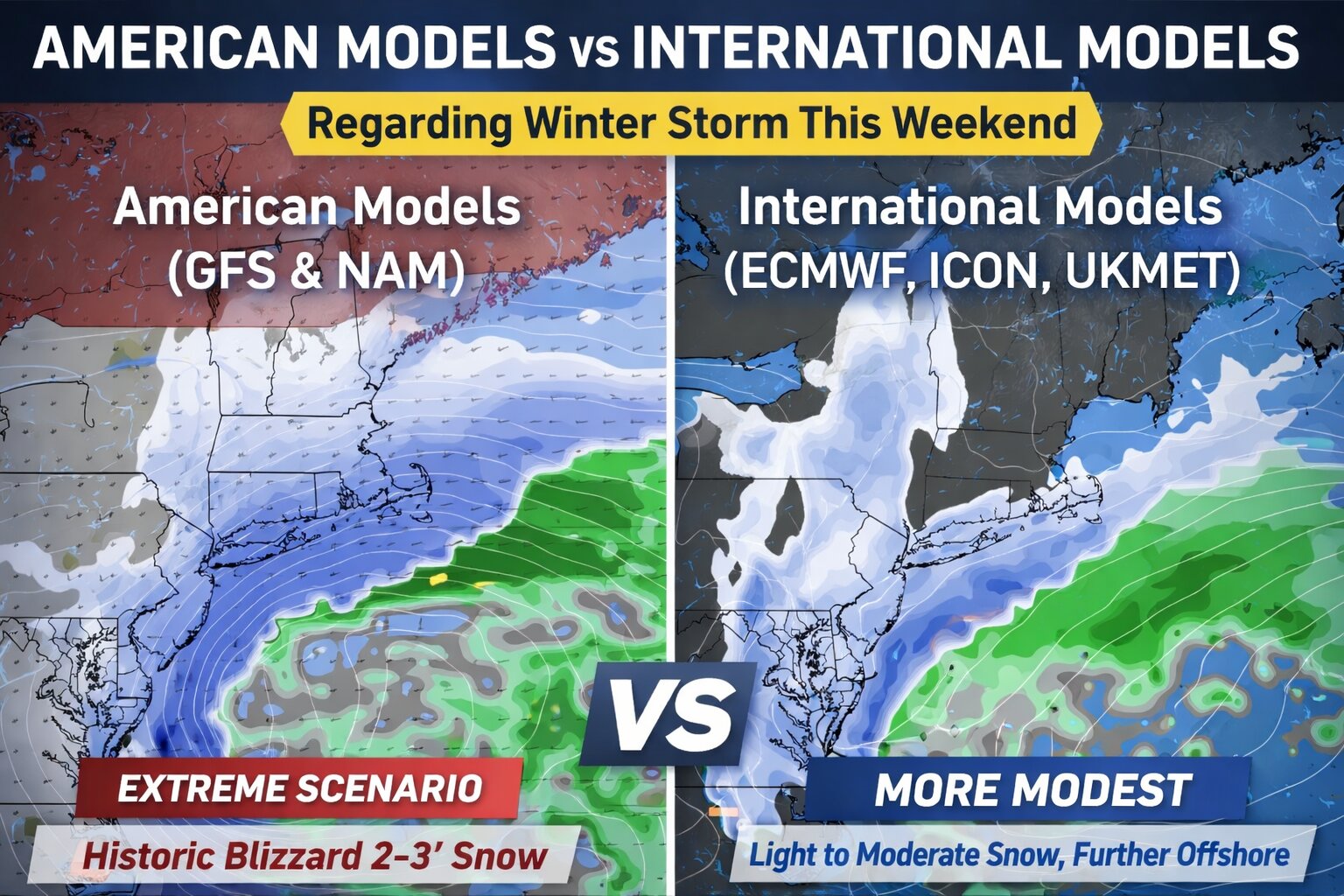
    Model solutions continue to vary widely. Some guidance depicts a stronger storm tucked closer to the Mid-Atlantic coastline, which would support heavier snowfall, stronger winds, and a higher risk of coastal flooding. Other solutions keep the storm weaker and farther offshore, which would result in lighter snowfall totals and potentially even some rain mixing in at the onset.

    There has been a subtle westward shift in some of the midday model runs, particularly with the ICON and UKMET, suggesting a slightly closer track. Meanwhile, the ECMWF has come into better agreement showing at least light snowfall accumulations across the entire area. Ensemble guidance, however, still shows significant spread, highlighting the continued uncertainty.

    It is worth noting that while some mid-range American models such as the GFS and NAM have hinted at an extreme scenario featuring 2 to 3 feet of snow in parts of the region, that solution currently appears to be an extreme outlier. At this time, confidence in a historic blizzard scenario remains very low. The overall snow threat is real and it is increasing, but the most extreme projections do not appear to be the most likely outcome.

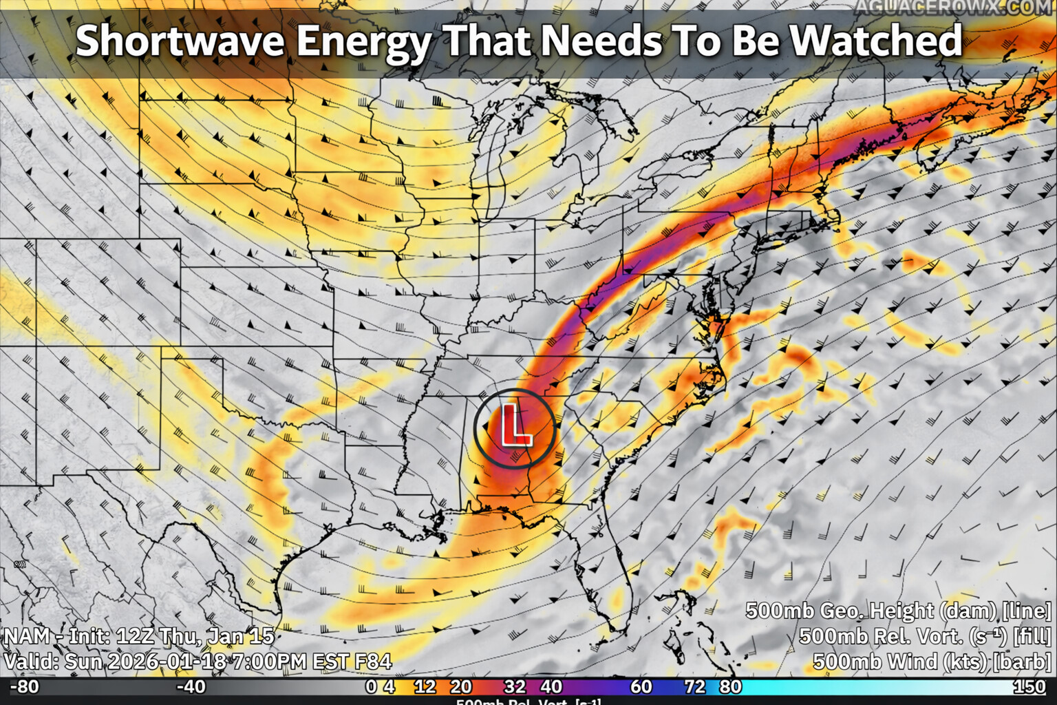
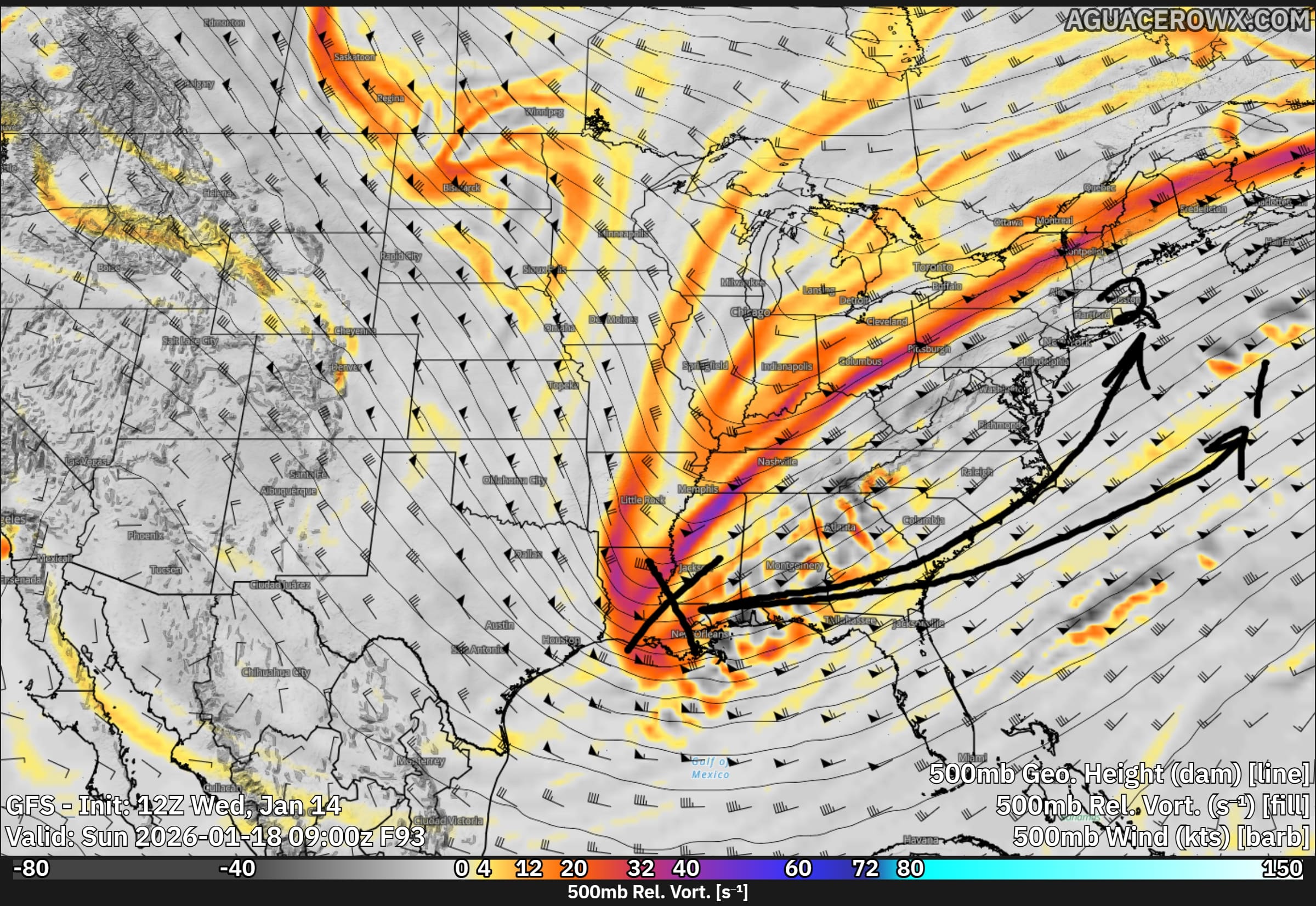
    High-resolution guidance is also offering important insight. Some CAMs, including the MPAS, show a significant reduction of snowfall on the backside of the system due to weaker phasing of upper-level energy. The timing and interaction of shortwave energy from the Midwest and West Coast will ultimately determine how amplified the upper-level trough becomes and whether the system achieves a more neutral or negative tilt. A stronger, phased system would support heavier snow, while weaker phasing would favor a more modest event.

    Another key factor will be boundary layer temperatures. The air mass ahead of the storm is not particularly cold, meaning surface temperatures will play a critical role in determining how efficiently snow accumulates. Even with a weaker solution, increasing northeasterly winds could develop Sunday into Monday, especially near the coast, raising at least some concern for minor coastal flooding.

    The bottom line: confidence is high that precipitation will occur Sunday into Monday, with an 80 to 90 percent chance of measurable precipitation. Confidence is increasing that a chuck of that is snow. However, it is too early to lock in specific totals or buy into extreme scenarios. Expect forecast adjustments as newer data continues to refine the storm’s evolution.

  • Unsettled Weekend Weather Possible Across Delmarva As Coastal System Develops With Snow Threat

    Unsettled Weekend Weather Possible Across Delmarva As Coastal System Develops With Snow Threat

    Residents across the Delmarva region will want to stay weather aware this weekend as multiple rounds of precipitation are possible, including the potential for snow. Forecast confidence remains moderate to low, but the overall pattern supports unsettled conditions from Saturday through Sunday night.

    A broad area of low pressure aloft, known as a longwave trough, will settle over the eastern United States this weekend. Several smaller disturbances moving through this pattern will help generate periods of precipitation, beginning early Saturday and possibly continuing into Sunday night.

    The first system is expected to move through Saturday morning and appears to be relatively weak. Precipitation may begin near or shortly after daybreak, when temperatures are at their coldest. Some locations could see a brief mix or light snow at the onset, especially inland areas, before temperatures rise through the morning. As daytime heating and weak warm air move in, most of Delmarva should transition to light rain. Any snow accumulation during this first round is expected to be minimal, with little more than a trace for most areas. Overall precipitation amounts should remain under a tenth of an inch.

    Attention then turns to a second system that could develop offshore late Sunday into Sunday night. This system carries more uncertainty and higher potential impacts, depending largely on how close the surface low tracks to the coast. Recent forecast guidance has shown a slight shift toward a closer approach, which has increased the chance for precipitation across the region, especially near coastal areas.

    With a cold front moving through Saturday night, colder air will be in place on Sunday. If the offshore low tracks close enough, much of the precipitation could fall as snow, particularly during the latter half of Sunday and into Sunday night. At this time, the probability of seeing measurable snow across coastal Delmarva is around 35 to 50 percent (of greater than 1″), with lower chances farther inland. The likelihood of higher snowfall amounts remains low, but it cannot be ruled out if the storm trends closer to the coast.

    While confidence has increased slightly compared to earlier forecasts, there is still considerable uncertainty regarding the exact track and strength of this system. Residents across Delmarva should continue to monitor the forecast through the weekend, as small changes in storm position could significantly impact precipitation type and amounts.

    More updates will be provided as forecast confidence improves.

  • Will It Storm Or Will It Be Another Dud? The Talk About Sun-Mon Storm Signal

    Will It Storm Or Will It Be Another Dud? The Talk About Sun-Mon Storm Signal

    We are gearing up to be in a fairly hostile pattern with many pieces of energy to play with here over the next 2 weeks as a large long wave trough sits over the eastern US. The biggest issue right now is do they interact with each other or will they remain strung out wasting the potential for snow lovers out there.

    While the overall risk of impactful wintry weather remains low heading into early next week, colder temperatures mean even small changes in the forecast could introduce a chance for snow.

    A brief warm up to near seasonal levels is expected Saturday ahead of a passing cold front. Behind it, a colder pattern looks likely to settle back in and persist through at least the middle of next week, with temperatures running below normal. During this time, several weak disturbances are forecast to move through the region. While none of these systems appear particularly strong on their own, there is a possibility they could interact in a way that brings a wintry weather threat late Sunday into Monday.

    At this time, the most likely outcome would be flurries or light snow, with limited or no accumulation. However, if the shortwave has more of a interaction with the Jetstream, that can bring larger impacts. Forecast confidence remains low, with precipitation chances generally in the 20 to 30 percent range.

    Given the cold air in place, this period will need to be monitored closely for any changes that could increase the wintry weather threat. For now, the risk of a significant winter storm from Sunday into early next week remains low, but not zero.

  • A Lot Of Talk About Wintry Weather Jan 6-8th…

    A Lot Of Talk About Wintry Weather Jan 6-8th…

    There has been a ton of speculation over social media about “Major Winter Storm Signal Jan 6-8th” and different variations for click bait and cash grabs for views. For many who know me over the last 15 years, I tell it like it is. And many of these social media pages need to keep their anticipation in check. I will go through the good and the bad for snow lovers with all this hype being shared around the internet about this timeframe.

    So the big take aways is what’s going on with the North America weather pattern changing a bit from this past week to a more colder one. But the biggest issues that people see on these maps is anytime they see a trough in the east immediately go “MAJOR WINTER SIGNAL, MAJOR STORM AHEAD” but there is so much more that goes into play. Yes we are looking at a trough across the eastern US, that’s only the first step. There is some blocking showing up in the arctic with the ECMWF but much weaker with the GFS. Blocking near Greenland helps slow down the overall weather pattern or for all the technical readers out there a -NAO block. So we have two pieces of the puzzle but there is something way more important in my opinion and its what’s going on the west coast.

    And that’s where my excitement starts going down the tubes as a snow lover. We need ridging in the west coast to get the trifecta ingredients. And this is where things start falling short for my liking. Not only that we have polar opposites in guidance between the two major long range models for this range and the placement is not ideal. Ridging along the west coast not only brings the cold air supply with cross polar flow and helps amplify the trough to its east. With this sitting over the Rockies, not the most ideal to get something off our coastlines. I prefer to have it back right at the coast instead but we also have a trough not too far away to the west side. ECMWF is your friend and the GFS is you enemy with the PNA across the west coast. Hard to say which will be correct until one switches as we get closer in time. This is why I have been thinking it’s so dumb to be stating about a storm is happening in this time frame because of the PNA in itself.

    One thing is for sure, we are looking to see some colder weather over in our neck of the woods going into the New Year. As temp anomalies over the next 1-2 week showing increasing confidence of “Below Average Temperatures” in the Mid-Atlantic & New England. Moral of the story, hold your excitement for now and be wary of pages that post this kind of hype and 384 hour snowfall maps claiming this is what’s ahead. It’s just not good and its a spreading terrible false information. It’s a cash grab for getting views and traffic for all the wrong reason. Trust your reliable sources friends.

  • NOAA Forecasts Above-Normal 2025 Atlantic Hurricane Season

    NOAA Forecasts Above-Normal 2025 Atlantic Hurricane Season

    The National Oceanic and Atmospheric Administration (NOAA) has issued its outlook for the 2025 Atlantic hurricane season, predicting above-normal activity. The season, which runs from June 1 through November 30, is expected to produce 13 to 19 named storms, with six to ten becoming hurricanes, and three to five reaching major hurricane status (Category 3 or higher).

    NOAA attributes the heightened activity to several factors, including warmer-than-average sea surface temperatures in the Atlantic Ocean and Caribbean Sea, and a neutral phase of the El Niño-Southern Oscillation (ENSO), which can influence hurricane development.

    “With the combination of warm ocean temperatures and neutral ENSO conditions, the atmosphere is primed for an active hurricane season,” said NOAA Administrator Rick Spinrad.

    This forecast aligns with projections from other institutions, such as Colorado State University and the UK Met Office, which also anticipate above-average hurricane activity for the 2025 season.

    NOAA emphasizes the importance of preparedness, urging residents in hurricane-prone areas to review their emergency plans and stay informed through official channels. The agency’s full fleet of satellites and advanced modeling systems will continue to monitor tropical activity throughout the season.

    For more information and updates, visit NOAA’s National Hurricane Center at www.nhc.noaa.gov.