
Millions more people across the globe could face coastal flooding dangers than previously calculated, according to groundbreaking research that exposes widespread errors in how scientists measure current sea levels.
A comprehensive analysis published Wednesday in the journal Nature examined hundreds of scientific papers and risk evaluations, discovering that roughly 90% incorrectly estimated existing coastal water heights by underestimating them by approximately one foot (30 centimeters) on average. The problem appears most severe in the Global South, Pacific regions, and Southeast Asia, while being less common along European and Atlantic shorelines.
The root of the issue stems from incompatible measurement methods for ocean and land elevations, explained study co-author Philip Minderhoud, who teaches hydrogeology at Wageningen University & Research in the Netherlands. He described this as a “methodological blind spot” between different measurement approaches.
While each measurement system works well for its intended purpose, complications arise at the critical junction where ocean meets shore, where satellite data and land-based models often miss important factors. Lead researcher Katharina Seeger from the University of Padua in Italy noted that impact studies typically “do not look at the actual measured sea level so they used this zero-meter” starting point. In certain Indo-Pacific locations, the actual difference reaches nearly 3 feet (1 meter), Minderhoud noted.
The measurement errors occur because many research projects assume calm ocean conditions without waves or currents, while actual coastal waters constantly experience disruption from wind, tides, currents, temperature changes, and phenomena like El Niño, both researchers explained.
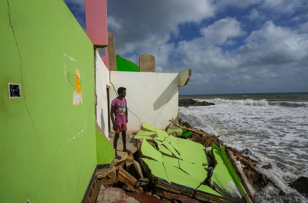
When scientists apply more precise coastal height measurements, the implications become alarming. Should ocean levels increase by slightly more than 3 feet (1 meter) — a projection some research suggests could occur by 2100 — flooding could affect 37% additional land area and endanger between 77 million and 132 million more individuals than current estimates predict.
These revised projections would create significant challenges for planning and funding climate adaptation efforts.
“You have a lot of people here for whom the risk of extreme flooding is much higher than people thought,” explained Anders Levermann, a climate researcher at Germany’s Potsdam Institute for Climate Impacts Research, who did not participate in the study. Southeast Asia, where the research identifies the largest measurement gaps, already contains the most people vulnerable to rising seas, he added.
Minderhoud highlighted island nations in that region as places where these measurement discrepancies have real-world consequences.
For Vepaiamele Trief, a 17-year-old climate advocate, these projections represent lived reality rather than abstract data. On her South Pacific island home in Vanuatu, the coastline has noticeably receded during her lifetime, with beaches washing away, coastal vegetation destroyed, and some residences now sitting just 3 feet (approximately 1 meter) from high tide waters. On her grandmother’s island of Ambae, rising waters forced officials to redirect a coastal airport road inland. Submerged burial sites and threatened traditional lifestyles illustrate the human cost.
“These studies, they aren’t just words on a paper. They aren’t just numbers. They’re people’s actual livelihoods,” she emphasized. “Put yourself in the shoes of our coastal communities — their lives are going to be completely overturned because of sea level rise and climate change.”
The research essentially focuses on determining ground-level reality.
Measurements that accurately represent open ocean conditions or inland terrain fail to capture the complex dynamics at the crucial water-land boundary, Seeger and Minderhoud explained. This issue particularly affects Pacific regions.
“To understand how much higher a piece of land is than the water, you need to know the land elevation and the water elevation. And what this paper says the vast majority of studies have done is to just assume that zero in your land elevation dataset is the level of the water. When in fact, it’s not,” said Ben Strauss, CEO of Climate Central and sea level rise specialist. His 2019 research was among the few the current paper identified as using correct methodology.
“It’s just the baseline that you start from that people are getting wrong,” Strauss noted, though he was not involved in this research.
Some independent scientists believe Minderhoud and Seeger may be overstating the significance of these measurement issues.
“I think they’re exaggerating the implications for impact studies a bit — the problem is actually well understood, albeit addressed in a way that could probably be improved,” said Gonéri Le Cozannet, a researcher with the French geological survey. Most local authorities understand their coastal challenges and develop plans accordingly, added Robert Kopp, a sea level specialist at Rutgers University.
Vietnam, located in the high-impact zone, demonstrates this local knowledge, Minderhoud acknowledged. Officials there maintain accurate elevation understanding, he said.
These findings emerge alongside a new UNESCO report highlighting significant gaps in understanding oceanic carbon absorption. That analysis revealed models vary by 10% to 20% when estimating carbon sink capacity, raising concerns about the reliability of global climate predictions that depend on such data.
Combined, both studies indicate governments may be developing coastal and climate risk strategies based on incomplete understanding of oceanic changes.
“When the ocean comes closer, it takes away more than just the land we used to enjoy,” said Thompson Natuoivi, a climate advocate with Save the Children Vanuatu.
“Sea level rise is not just changing our coastline, it’s changing our lives. We are not talking about the future — we’re talking about the right now.”