Tag: wx

  • Strong Coastal Low Could Bring Major Impacts to Delmarva This Weekend

    Strong Coastal Low Could Bring Major Impacts to Delmarva This Weekend

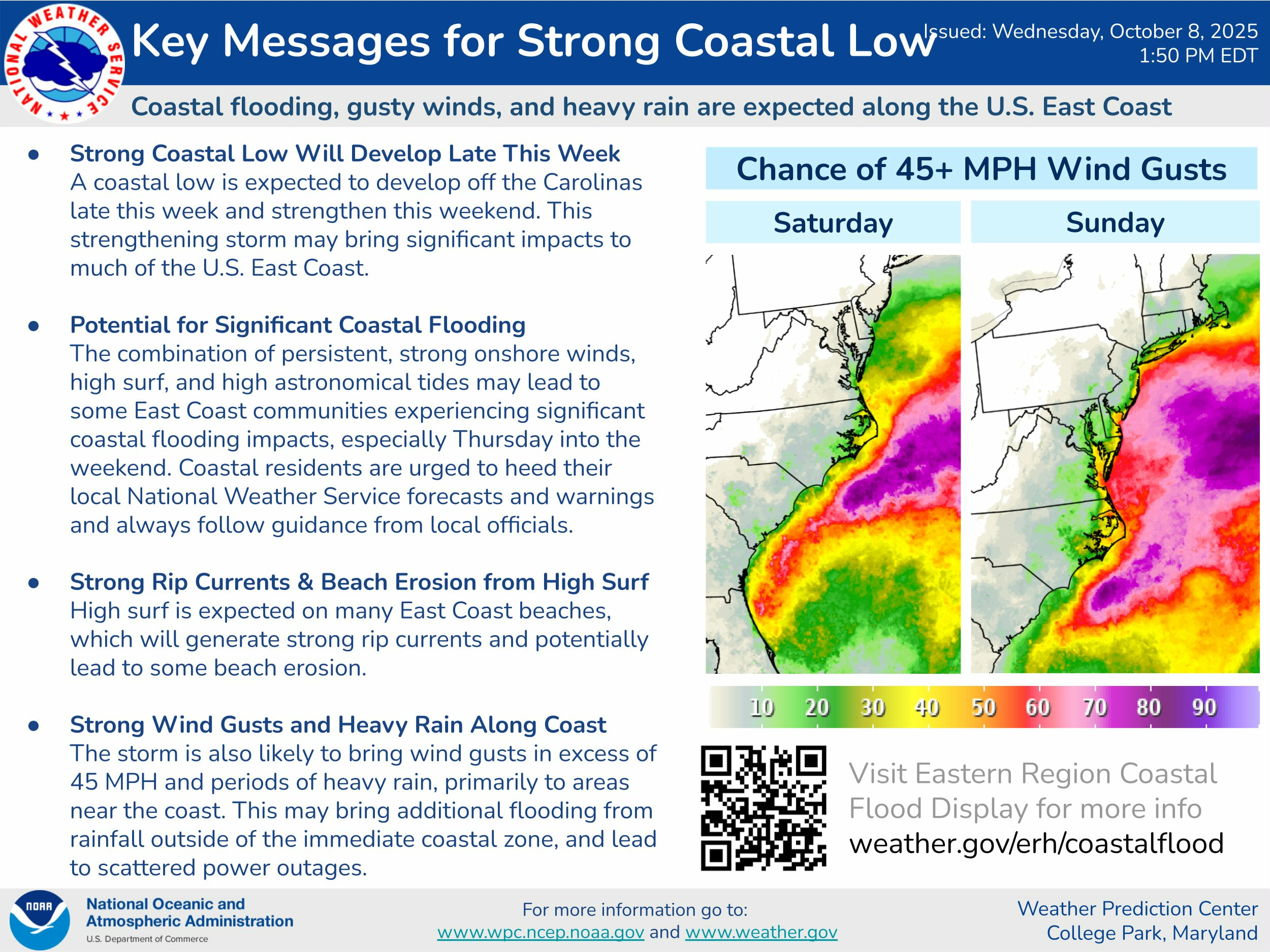
    A powerful coastal low is forecast to develop off the Carolina coast late this week before strengthening and tracking northward this weekend. The system is expected to bring gusty winds, heavy rain, and coastal flooding to much of the East Coast — including the Delmarva Peninsula.

    The combination of strong onshore winds, high surf, and high astronomical tides could lead to significant coastal flooding across parts of Delaware, Maryland, and Virginia. The most widespread impacts are expected from Friday night through Sunday, with the highest risk during periods of high tide.

    Persistent onshore winds will also generate dangerous rip currents and high surf, likely leading to beach erosion along the Atlantic coastline and the lower Delaware and Chesapeake Bays. Coastal residents should closely monitor updates and follow any advisories issued by local emergency management or the National Weather Service.

    In addition to flooding, the storm could bring wind gusts over 45 mph, especially along coastal areas, which may result in scattered power outages and tree damage. Heavy rainfall could also lead to localized flooding inland, particularly in poor drainage areas.

    The Weather Prediction Center highlights the Delmarva coast as an area of elevated concern for strong wind gusts and coastal flooding potential this weekend.

    Residents are urged to stay alert as the system approaches and to secure outdoor items ahead of the storm.

  • GOES-19 Goes Operational Across The US

    GOES-19 Goes Operational Across The US

    A very exciting day in the weather world. Welcome to GOES-19, the brand new updated satellite covering the United States is now in operation!

    GOES-19, formerly known as GOES-U, introduces significant enhancements over its predecessor, GOES-16, particularly in space weather monitoring. A notable addition is the Compact Coronagraph-1 (CCOR-1), the nation’s first operational coronagraph, designed to observe the solar corona and detect coronal mass ejections (CMEs). This instrument provides imagery within 30 minutes of acquisition, a substantial improvement over the previous system’s eight-hour delay, thereby enhancing space weather forecasting capabilities.

    GOES-19 continues the high-temporal resolution imaging capabilities introduced with the GOES-R series but maintains and enhances rapid updates for weather monitoring.

    • Full-Disk Updates Every 5 Minutes: GOES-19 can scan the entire Earth every five minutes, providing near-real-time global coverage to track weather systems, storms, and environmental changes. This allows meteorologists to monitor rapidly developing weather patterns with high-frequency updates.
    • Mesoscale Region Updates Every 30 Seconds: In high-impact weather events, GOES-19 can focus on two mesoscale sectors simultaneously, delivering images every 30 seconds per region. This is crucial for tracking severe thunderstorms, hurricanes, wildfires, and other rapidly evolving atmospheric phenomena, offering nearly real-time updates for forecasters.

    These rapid update capabilities, combined with its advanced instruments like the Advanced Baseline Imager (ABI) and Geostationary Lightning Mapper (GLM), allow GOES-19 to provide even more detailed and timely data, improving short-term forecasting, severe weather warnings, and disaster response efforts.

    ​GOES-19, previously known as GOES-U, introduces several advanced features over its predecessor, GOES-16, enhancing both Earth and space weather monitoring capabilities.​

    Enhanced Magnetometer (GMAG): GOES-19 is equipped with an upgraded magnetometer that offers improved measurements of Earth’s magnetic field compared to earlier GOES-R series satellites.

    These advancements position GOES-19 as a critical asset in NOAA’s mission to provide timely and accurate environmental data, ensuring improved forecasting and preparedness for both terrestrial and space weather phenomena.

  • New Cold Weather Alerts Aim to Simplify Messaging and Highlight Dangers

    New Cold Weather Alerts Aim to Simplify Messaging and Highlight Dangers

    As winter approaches, significant changes are coming to how extreme cold is communicated to the public. Starting this season, the National Weather Service (NWS) will replace wind chill watches, warnings, and advisories with extreme cold watches, warnings, and advisories. This shift aims to enhance understanding of cold weather hazards and ensure that the dangers of low temperatures are effectively conveyed.

    What’s Changing?

    Previously, wind chill alerts were issued only when wind speeds exceeded 10 mph, focusing solely on the combined effect of wind and low temperatures. However, under the new system, alerts will be based on the apparent temperature, which is the lower value of air temperature or wind chill. This adjustment acknowledges that dangerous cold can occur even in calm conditions.

    For example, if the air temperature drops to life-threatening levels but winds remain light, the new extreme cold warning would still be issued—something the prior system didn’t account for.

    Why the Change?

    The updated system reflects a growing understanding of how cold weather impacts people and communities. By removing the 10 mph wind threshold, the change aims to streamline cold weather alerts and emphasize that frigid temperatures can be dangerous with or without wind.

    Wind chill, however, is not disappearing—it will still be forecasted and reported as a key factor in winter weather conditions. The new terminology is designed to simplify messaging for the public while accounting for broader climatological and health impacts.

    New Guidelines for Alerts

    The thresholds for issuing extreme cold watches, warnings, and advisories have been refined to align with historical climate patterns and their potential impacts. These changes also incorporate insights from recent winters, where dangerously low temperatures have posed threats even in the absence of strong winds.

    • Cold Weather Advisory: Issued for conditions that could cause discomfort or mild health impacts for vulnerable populations.
    • Extreme Cold Watch: Used to signal the potential for dangerous cold weather conditions within a few days.
    • Extreme Cold Warning: Issued when life-threatening cold is imminent or occurring.

    A Clearer Message for Safety

    By simplifying the criteria and expanding the scope of dangerous cold conditions, the new system seeks to reduce confusion and encourage timely action during winter weather events. Whether it’s protecting yourself from frostbite and hypothermia or ensuring pets and pipes are safe, these changes emphasize preparedness for all cold weather scenarios.