Tag: wintry mix

  • Wintry Mix Followed By Arctic Cold To Finish Work Week

    Wintry Mix Followed By Arctic Cold To Finish Work Week

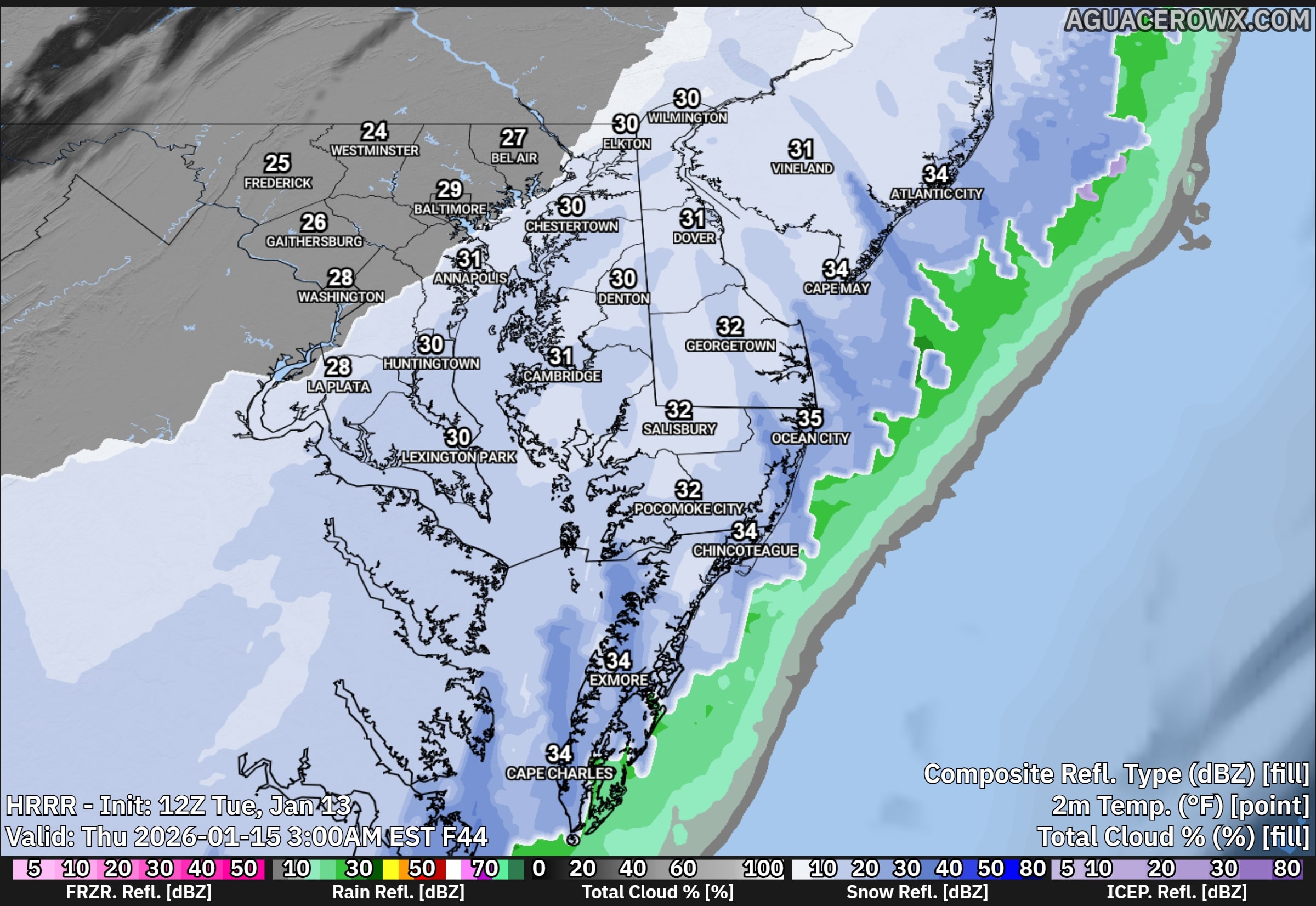
    A developing storm system will bring a brief period of light rain to Delmarva late Wednesday, with the potential for a few snowflakes before the precipitation ends early Thursday. While impacts from precipitation look minimal, the bigger story will be the sharp drop in temperatures and strong winds that follow and last into Friday.

    On Wednesday, a cold front associated with a passing system to our north will move through the region. This front will help produce a shield of light precipitation across the area Wednesday afternoon and evening. With temperatures starting off mild, most locations on Delmarva will see rain initially. As colder air moves in overnight, rain could briefly mix with or change to snow before ending early Thursday morning. Any snow accumulation is expected to be very light, with little to no impact expected across Delmarva.

    A secondary storm system is expected to develop offshore along the Carolina coast late Wednesday night into Thursday. Current forecast guidance keeps this system well offshore, meaning it should have little to no effect on our region. Because of this, confidence remains high that Thursday will be largely dry, aside from a small chance of lingering light precipitation early in the morning.

    Temperatures will be relatively mild ahead of the front on Wednesday, with highs ranging from the mid 40s to near 50 degrees across Delmarva. Conditions will change quickly Wednesday night as colder air pours into the region. By Thursday morning, temperatures will drop into the mid 20s to near 30 degrees. Strong west to northwest winds will develop, creating wind chills in the teens and lower 20s through much of the day.

    Thursday will feel bitterly cold and blustery, with sustained winds of 15 to 25 mph and gusts occasionally reaching 30 to 35 mph. Afternoon temperatures will struggle to recover, only reaching the upper 20s to mid 30s despite some sunshine.

    The coldest air arrives Thursday night into early Friday. Overnight lows will fall into the teens and lower 20s across Delmarva, and persistent winds will push wind chills into the single digits by Friday morning. Friday remains cold, with highs once again in the upper 20s to mid 30s and wind chills staying in the lower to mid 20s.

    While this system will not bring significant precipitation, the combination of strong winds and sharply colder temperatures will make it feel more like mid winter across Delmarva heading into the end of the week.

  • An Icy Boxing Day On The Way For The Mid-Atlantic States

    An Icy Boxing Day On The Way For The Mid-Atlantic States

    Its shaping up to be a fairly icy day after Christmas for many across the Mid-Atlantic states Friday into Saturday. A classic “Overrunning Event” to unfold as a warm front moves into arctic air that’s trapped across New England forced by northeast winds ahead of the precip.

    An overrunning event in winter meteorology occurs when warm, moist air is lifted up and over a shallow layer of cold air at the surface. This setup is common ahead of winter storms and often develops north of a warm front. Because cold air is denser, it remains trapped near the ground while warmer air flows over it along sloping isentropic surfaces.

    As the rising warm air cools, clouds and precipitation develop well in advance of the main storm system. In winter, this frequently leads to widespread, long-duration precipitation, often falling as snow, sleet, or freezing rain, depending on the temperature profile of the atmosphere. Overrunning events are typically associated with stratiform precipitation, lower visibility, and steady rather than convective rainfall or snowfall.

    These events can produce significant winter weather impacts, including heavy snow accumulations, ice accretion, and hazardous travel conditions, especially when cold air is reinforced at the surface by high pressure to the north. Overrunning precipitation often marks the initial phase of a winter storm before stronger dynamics and surface low pressure move in.

    With the latest guidance at this time, areas closer towards the Mason-Dixon have the greatest threat for looking at snow and ice accumulations as the cold air will be locked up better in those regions. totals wise at this time is not for certain the amount of snow/ice is expected with this system as we get a bit closer in time. Areas across Central Delmarva will start off with that wintry mix but eventually change over to plain rain as the winds turn a bit more easterly which will bring in that warmer Atlantic air across the region.

  • Potential Winter Storm Threat Looming Early Next Week

    Potential Winter Storm Threat Looming Early Next Week

    Just when it seemed like winter might be winding down, another round of winter weather is on the horizon. After a brief break from bitter cold and snow, forecast models indicate that winter storm threats will return next week, affecting the Midwest, Mid-Atlantic, and Northeast. This won’t be just one isolated storm, but several waves of wintry weather are expected. This setup is similar to the major winter storm we experienced in early January, featuring a classic “overrunning” pattern, which often produces significant snowfall in our region. But what exactly is an overrunning winter storm?

    An overrunning winter storm occurs when warm, moisture-laden air moves over a colder, denser air mass at the surface, leading to prolonged periods of wintry precipitation. This happens when warm air from the south collides with cold air entrenched to the north. Unlike last time, however, this system is being driven by a strong Arctic high-pressure system, rather than a blocking low-pressure system to the north. Scientifically, this process is known as Isentropic Ascent—a term used to describe how air is lifted along a temperature gradient.

    Current mid-range model guidance (GFS, ECMWF, UKMET, CMC, ICON) consistently shows an overrunning event with multiple waves of low pressure traveling along a stalled frontal boundary. A strong high-pressure system (1038-1040mb) will provide ample cold air north of this boundary, while incoming warm, moist air will fuel heavy precipitation. The exact position of the frontal boundary will determine whether areas experience heavy snow, plain rain, or, in the worst-case scenario, significant icing. Overrunning setups are notorious for producing dangerous ice storms, as cold air remains locked at the surface while warm air aloft causes precipitation to fall as freezing rain or sleet—leading to hazardous road conditions.

    The Weather Prediction Center (WPC) has already issued impact probabilities for next week’s potential winter storm, indicating a 50-60% chance of Minor Winter Storm Impacts and a 40-60% chance of Moderate Winter Storm Impacts. This suggests that disruptions to travel and infrastructure closures could occur.

    We’ll continue to monitor the latest forecast developments and provide real-time updates as this potential winter storm approaches early next week. Stay tuned for the latest information.

  • Increasing Threat of a Snow Event Sunday Night into Monday For Delmarva

    Increasing Threat of a Snow Event Sunday Night into Monday For Delmarva

    A potential snow event is taking shape for Sunday night into Monday as a dynamic weather pattern evolves. Heading into the weekend, an Arctic boundary is expected to push through the region, bringing temperatures into the upper 40s along with rain. However, a secondary piece of energy trailing behind the front will interact with the boundary, allowing a new low-pressure system to rapidly develop. This setup could result in light to moderate snow accumulations across parts of the area.

    Model Analysis and Comparisons

    ECMWF (European Model):
    Currently one of the most reliable models, the ECMWF suggests a light snow event affecting much of Delmarva and extending into the western shore of Maryland. Projected snowfall totals range between 1 and 4 inches, which aligns with current trends. However, areas along the southern shore may experience a mix of rain and snow due to the proximity of the low-pressure center and the Arctic front.

    UKMET, CMC, and RGEM Models:
    These models present a less favorable scenario for snowfall on the shore, with a more northern storm track that shifts the focus of snow accumulation to Pennsylvania, New Jersey, and extreme northwestern Maryland. The CMC and RGEM in particular show no significant snow accumulations for Delmarva. The UKMET, however, highlights a snow band producing 2 to 4 inches across northern Delmarva, aligning more closely with the ECMWF in terms of low-pressure positioning.

    GFS Model:

    The GFS takes a more expansive approach, forecasting widespread snowfall across the region. Accumulations of 2 to 5 inches are indicated from Easton to Dover and northward toward Wilmington. However, the GFS has shown considerable variability and currently holds the lowest verification rate among the models.

    Key Takeaways

    Confidence is increasing for another accumulating snow event across the region late Sunday into Monday. While there is still some uncertainty regarding the exact track of the low-pressure system and snow totals, current trends suggest a light to moderate event is possible, particularly for snow-prone areas on Delmarva. The National Blend of Models (NBM) also supports the potential for snowfall, giving some hope to snow enthusiasts before the arrival of extreme cold next week.

    Stay tuned for updates as this system develops.