Tag: winter weather

  • Winter Uncertainty Towards The Late Week; Social Media Hype Is Crazy Right Now

    Winter Uncertainty Towards The Late Week; Social Media Hype Is Crazy Right Now

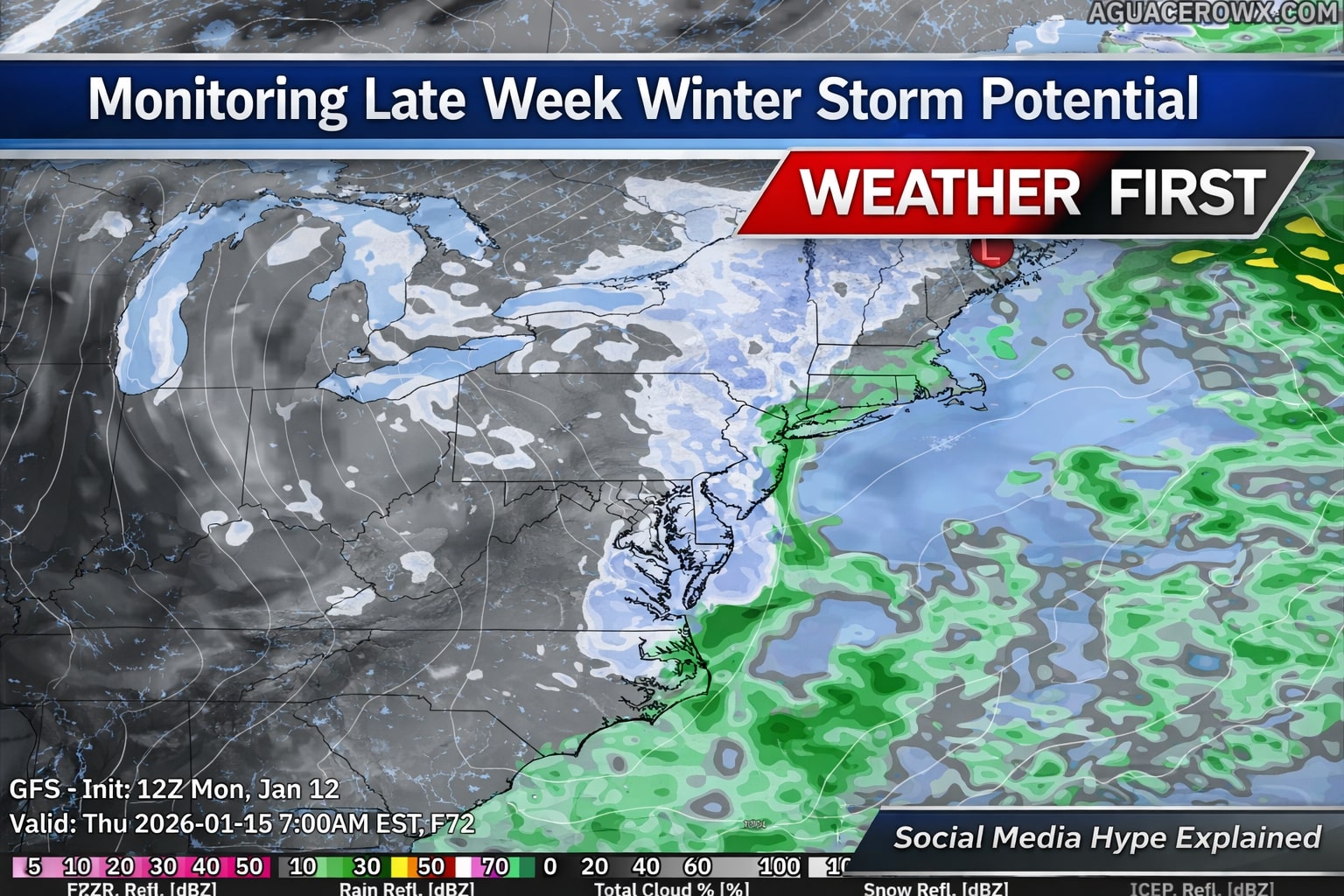
    Forecast guidance continues to signal the potential for a disruptive winter weather pattern later this week, mainly from Wednesday through Friday, as an upper level low strengthens over the Lower Great Lakes and moves toward the Northeast. This system is expected to bring an increase in wintry precipitation across parts of the Lower Great Lakes, the central Appalachians, and portions of the interior Northeast, with colder air also setting the stage for lake effect snow in typical snowbelt regions.

    However, confidence in the overall setup remains low. Key details such as the exact placement and strength of the upper level low are still uncertain, which will ultimately determine where the heaviest precipitation develops. There is also considerable question surrounding coastal low development, including whether it forms too late, remains weak, or tracks well offshore. Recent trends as of today favor a later developing system that stays farther out to sea, which would significantly limit impacts for much of the I-95 corridor.

    The primary question for Delmarva centers on whether a coastal low is able to develop in time and close enough to influence the region. Current guidance shows large spread in both timing and track, with recent trends favoring a system that forms too late and remains well offshore. If this trend holds, meaningful winter weather impacts across Delaware, eastern Maryland, and Virginia’s Eastern Shore would be limited or possibly avoided altogether.

    Because of these uncertainties, forecast impacts to travel and infrastructure remain unclear at this time. While some wintry weather is possible inland, especially across higher elevations and areas closer to the Great Lakes, any coastal impacts would depend on how quickly and how close a coastal low can organize. Forecast confidence should improve over the next few days as the system comes into better range of higher resolution models.

  • January Thaw Ongoing For Now, Winter Making A Return Towards Next Week

    January Thaw Ongoing For Now, Winter Making A Return Towards Next Week

    With days as of this past week constantly being int he 50’s and even 60’s, many wonder where did winter go? Normally in the winter months across the lower 48 go through a longer duration warming trend as a recharge of the overall pattern and sign are pointing at a return to more winter weather moving back across the eastern half of the US.

    Weather models are all onboard for a bigger shift in the overall weather pattern across the Northern Hemisphere Mainly what’s going on across the Pacific Ocean which is the biggest driver to the Lower 48 weather pattern for supplying the cold air and the active storm track. One thing that is peaking my interests is a significant drop in the Eastern Pacific Oscillation during the time period of the 14th-20th.

    A very large negative Eastern Pacific Oscillation, or EPO, is a significant large scale weather pattern that can strongly influence temperature and storm tracks across the United States, especially during the fall and winter months.

    When the EPO is strongly negative, a powerful ridge of high pressure builds over the eastern Pacific, often near Alaska and the Gulf of Alaska. This ridge acts as a blocking feature, forcing the jet stream to buckle sharply northward into Alaska and then dive southward downstream into western and central North America. As a result, Arctic air is displaced south out of Canada and into the United States.

    For the western United States, a negative EPO often brings colder than normal temperatures, particularly to the Pacific Northwest and northern Rockies. The ridge offshore can suppress precipitation along parts of the West Coast, leading to drier conditions in California, while the colder air aloft supports snow in the higher elevations of the Northwest and Intermountain West when storms are able to undercut the ridge.

    Across the central and eastern United States, the downstream response to a negative EPO is often a broad trough, which allows cold air to spill southward. This can lead to below normal temperatures across the Plains, Midwest, and East Coast. When moisture is available, this pattern can be favorable for winter storms, as cold air at the surface can interact with southern stream systems or coastal lows.

    The strength of the negative EPO matters. A weak negative phase may only produce brief or modest cold shots, while a strongly negative EPO can support prolonged cold outbreaks, sometimes reaching deep into the southern United States. This setup can also increase the likelihood of sharp temperature swings if the blocking ridge eventually breaks down.

    Weather across the Eastern US might get very interesting going forward into the mid-month.

  • Winter Takes a Break Across The Country But For How Long?

    Winter Takes a Break Across The Country But For How Long?

    The month of December brought well below average temperatures across much of the Mid-Atlantic region. Averaging as much as 4 to 6 degrees below normal. Putting impacts on energy costs already this early into the season but we are looking to see some relief on those heating bills over the next week. starting Tuesday, we flip the switch from being the freezer to being able to thaw out in a big way.

    Throughout the rest of this week, we are about to go from January weather to what i would say be ;ate October weather as we start cranking up to the 50s. Eventually towards the weekend we are even crossing the 60s threshold. Which is going to feel quite nice after being stuck every day in the 30s. But the real question lies, how long will this warm up will last?

    It appears this will be a week long warm up with the warmest time frame appearing closer to the weekend with highs approaching the mid 60s. But also bring the onset of rain chances as a storm system will be lifting up towards the Great Lakes area. But towards the mid-month, signs are pointing to a return of the west coast ridge allowing for troughs to extend east towards the Mid-Atlantic to bring back more seasonable temperatures. Cold air intrusion would be possible after the 15th when this occurs so that’s when any snow chances would return as of now.

    Enjoy the warmth and thaw while it last as we still have a whole lot of winter to get through!

  • One Of The Coldest January Thus Far In The Last 30-40 Years.

    One Of The Coldest January Thus Far In The Last 30-40 Years.

    *Graphic Provided By The National Weather Service Wakefield, VA*

    As we examine the climate data for January, we have observed some significant trends. So far this month, average temperatures in our region have consistently been 7 to 9 degrees colder than normal. While this cold weather is not unprecedented, all of our long-term climate monitoring stations are reporting the lowest average temperatures for the first 23 days of January in over 30 years, with certain areas such as Richmond, Salisbury, and Elizabeth City recording their coldest temperatures in over 40 years.

    Looking ahead, we anticipate temperatures will begin to stabilize, with averages returning closer to normal levels in the coming week as we near the end of the month. This indicates that while the current temperature deviations are notable, they may decrease somewhat. Nonetheless, we project that Salisbury and Elizabeth City are likely to secure spots on the top 10 coldest January lists by month’s end. Richmond may be on the cusp of making this list, but it is more probable it will fall just outside the top 10. In the meantime, Norfolk, which has a weather record extending over 150 years, is expected to rank between the 15th and 20th coldest January.

    Stay warm everyone, and please keep an eye on those temperature fluctuations! #WeatherUpdate #ColdWeather #JanuaryTemperatures #ClimateChange #StayWarm #TemperatureRecord #Meteorology

  • Snowfall On The Way Friday Into Saturday

    Snowfall On The Way Friday Into Saturday

    A period of light snow from a clipper system will arrive during the late overnight hours on Friday through the early morning hours Saturday. A fast moving area of low pressure from the Northern Plains will race just to the south of us through southern Virginia bringing a round of light snowfall accumulations. At this time it looks to be a nice spread of 1-3 inches of snowfall from areas of the Maryland Eastern Shore on northward. There maybe some localized heavier bands that could see 3 to 4 inches.

    As far as travel impacts for the morning hours on Saturday, accumulations of snowfall will be mostly on elevated and grassy surfaces. Road temperatures are on the warmer side and given temperatures will be marginal. This will be a wet snow in nature which could lead to a few slick spots here and there. Snowfall will taper off just after sunrise and will likely start melting throughout the day when temperatures rise above 32 degrees and the higher angle sun.