Tag: windy

  • Major Nor’easter to Bring Blizzard Conditions to Delmarva Sunday into Monday

    Major Nor’easter to Bring Blizzard Conditions to Delmarva Sunday into Monday

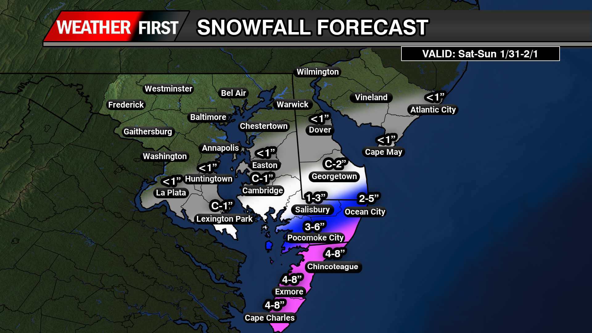
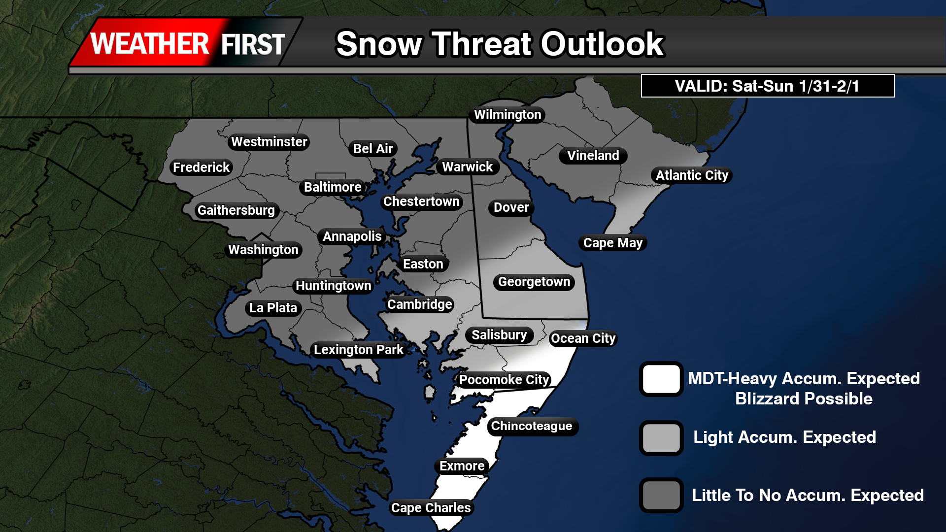
    A powerful late-February nor’easter is expected to significantly impact the Delmarva Peninsula from Sunday afternoon through Monday evening, bringing heavy snow, strong winds, and potentially dangerous travel conditions.

    This storm will rapidly intensify off the Mid-Atlantic coast, creating a period of heavy snowfall and localized blizzard conditions across coastal Delaware and portions of inland Sussex County.

    Heavy Snow and Strong Winds

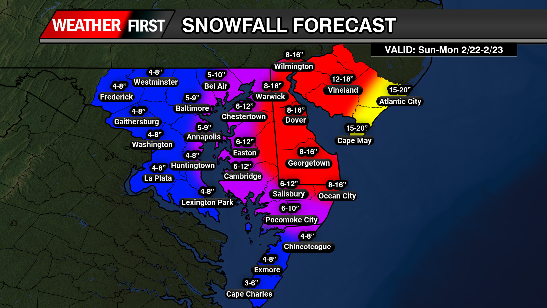
    Snow is expected to overspread Delmarva Sunday afternoon, becoming heavy at times Sunday night into early Monday. Snowfall rates could exceed one to two inches per hour during the height of the storm.

    Total accumulations across parts of the peninsula could reach significant levels, especially closer to the Delaware beaches, where blowing and drifting snow may greatly reduce visibility.

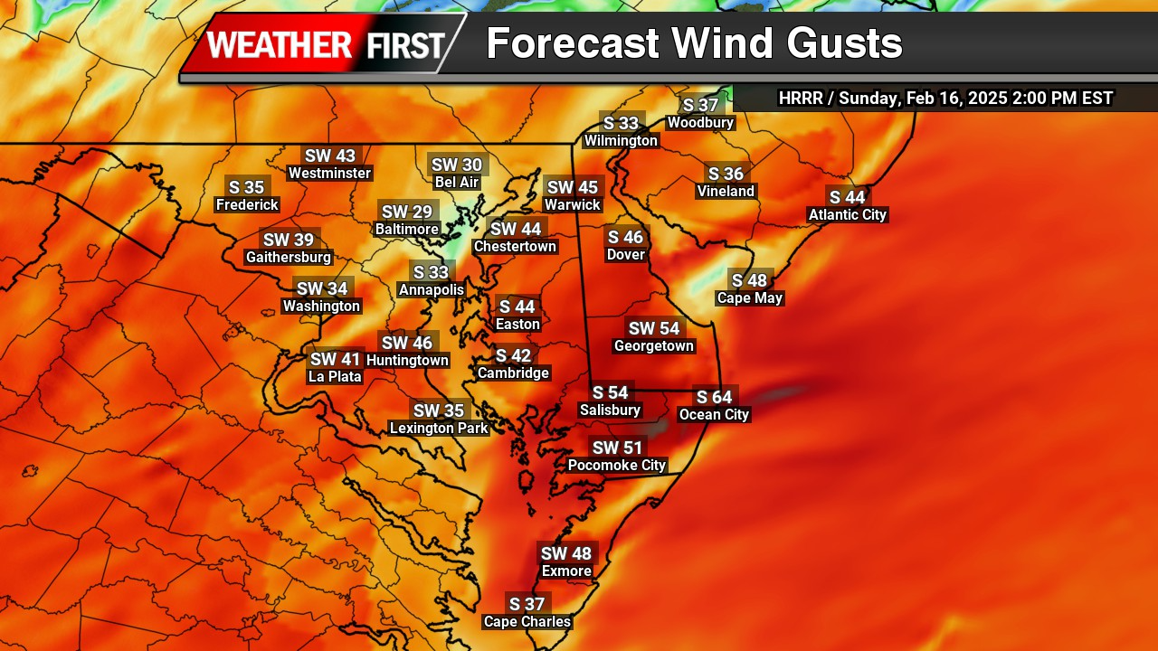
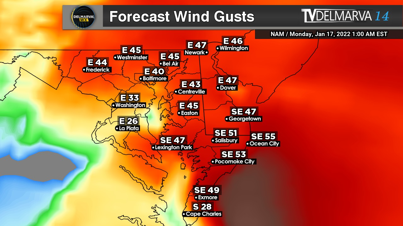
    In addition to heavy snowfall, strong northeast winds are expected to increase through Sunday night. Wind gusts between 40 and 60+ mph could create whiteout conditions, particularly along coastal areas. These winds will also lead to significant drifting, making roads impassable in some locations.

    Travel Could Become Extremely Dangerous

    The combination of heavy snow and strong winds may produce localized blizzard conditions across coastal Delmarva. Visibility could drop below a quarter mile at times, especially during peak snowfall rates.

    Travel is expected to become very difficult Sunday night into Monday. Both the Monday morning and evening commutes could be heavily impacted if conditions worsen as expected.

    Residents are urged to limit travel to emergencies only. If travel is unavoidable, motorists should carry a winter survival kit and be prepared for rapidly deteriorating conditions.

    Power Outages Possible

    Strong winds combined with heavy, wet snow could lead to scattered power outages across Sussex County and nearby coastal communities. Tree damage is possible, particularly where snowfall accumulates on limbs before peak wind gusts arrive.

    Coastal Concerns

    Moderate coastal flooding and beach erosion are also possible along the Delaware coastline, especially during times of high tide as strong onshore flow persists.

  • Coastal Winter Storm to Bring Snow, Wind, and Tidal Concerns to Delmarva This Weekend

    Coastal Winter Storm to Bring Snow, Wind, and Tidal Concerns to Delmarva This Weekend

    A rapidly intensifying coastal storm is expected to develop off the East Coast this weekend, bringing a combination of snow, strong winds, and coastal flooding concerns to parts of the Delmarva Peninsula. While the storm is forecast to track far enough offshore to limit widespread impacts inland, coastal and southern portions of Delmarva remain at risk for more significant winter weather impacts.

    Snowfall Forecast

    Snowfall amounts across Delmarva will feature a very sharp gradient, with accumulations increasing quickly from north to south and from inland areas toward the coast.

    Northern and central Delaware, along with much of interior Maryland’s Eastern Shore, are expected to see little accumulation, generally less than 1 inch. This includes areas such as Dover, Easton, and much of inland Kent and Queen Anne’s counties.

    Across central Delmarva, including Cambridge and Georgetown, snowfall totals are forecast to range from a coating up to around 1 inch, with 1 to 3 inches possible near Salisbury.

    The highest snowfall totals are expected along the coast and across southern Delmarva. Ocean City could see 2 to 5 inches of snow, while farther south, Pocomoke City is forecast to receive 3 to 6 inches. The most significant accumulations are expected across Chincoteague, Exmore, and Cape Charles, where 4 to 8 inches of snow remain possible.

    We stress that even small shifts in the storm’s track could result in noticeable changes to snowfall totals, especially along the northern edge of the heavier snow band.

    Timing and Impacts

    Snow is expected to develop Saturday night, with the highest confidence for accumulation occurring overnight into Sunday morning. Snow should gradually taper off from west to east by late Sunday morning.

    Strong winds will become an increasing concern early Sunday morning through Sunday evening, coinciding with the period of rapid storm intensification offshore. Gusts along the Delmarva coastline could approach or exceed 55mph, especially in exposed coastal locations.

    The combination of snow and strong winds could lead to blowing and drifting snow, particularly in southern Delaware and along the coast. These conditions may reduce visibility and create hazardous travel, even where snowfall totals are not extreme.

    Coastal Flooding Concerns

    At least minor tidal flooding is possible during the high tide cycle on Sunday, with some impacts potentially lingering into Monday. While wind direction is expected to limit more severe flooding, higher astronomical tides associated with the full moon, combined with increasing offshore swells, may exacerbate water level rises.

    Additional complications include existing ice on bays and waterways, which could influence how water levels respond during high tide.

    Forecast Confidence

    Confidence is increasing that Delmarva will experience impacts from this winter storm, though confidence in exact snowfall placement remains below average. The storm is expected to remain offshore, but a shift of as little as 50 miles could significantly change snowfall totals across the peninsula.

    Residents across Delmarva, especially in coastal and southern communities, are urged to monitor the forecast closely as additional updates and potential advisories may be issued over the next 24 hours.

  • Major Winter Storm Becoming Likely Across Southern Delmarva; Blizzard Conditions Possible

    Major Winter Storm Becoming Likely Across Southern Delmarva; Blizzard Conditions Possible

    A rapidly intensifying coastal storm is expected to develop off the East Coast this weekend, and while confidence in exact impacts remains limited, portions of the Delmarva Peninsula could see effects ranging from snowfall and strong winds to coastal flooding.

    Forecast guidance continues to show cyclogenesis beginning Saturday off the southeastern United States coast. As low pressure rapidly deepens, the system is expected to track north and east Saturday night into Sunday. This development is being driven by a potent upper-level disturbance rotating around the base of a longwave trough over the eastern United States, interacting with a sharp temperature contrast along the coast.

    For Delmarva, impacts will depend heavily on the exact track of the storm, which remains uncertain. Current guidance places much of the region on the northwest fringe of the precipitation shield. Small shifts in the storm’s path could make the difference between limited impacts and a more impactful winter weather event, particularly for southern and coastal Delaware.

    Among the latest forecast models, solutions remain mixed. Some guidance continues to suggest light snowfall for parts of Delaware, while others are more suppressed and keep meaningful precipitation offshore. At this time, forecast confidence supports the possibility of light to moderate snow accumulations in southern Delaware, with lesser amounts farther north. Additional snow could fall beyond early Sunday depending on how quickly the system departs.

    Snowfall probabilities remain highest closer to the coast. Current probabilistic guidance shows a 60 to 70 percent chance for more than 2 inches of snow near coastal areas, decreasing to 25 to 35 percent near the I-95 corridor. The probability of 6 inches or more remains lower, but remains notable near the coast where probabilities range from 35 to 50 percent.

    Regardless of snowfall totals, confidence is increasing that strong winds will affect the region Saturday night into Sunday. Northerly to northeasterly winds are expected to increase inland to 15 to 25 mph with gusts up to 35 mph. Along the coast, winds could reach 25 to 35 mph with gusts approaching 50 mph. If the storm tracks closer to the coast, winds could be stronger than currently forecast.

    Given the combination of strong winds and falling or blowing snow, there is a conditional risk for blizzard conditions in portions of southern Delmarva, especially near coastal areas. While confidence is not yet high enough for blizzard headlines, blizzard warnings could become necessary if the storm track shifts closer and snowfall rates increase alongside the strongest winds.

    Strong onshore winds will also increase the risk for coastal flooding, particularly during times of high tide. This threat is further heightened by the presence of a full moon, which will result in astronomical high tides. If strong northeasterly winds persist during peak tidal cycles, water levels could rise more quickly and lead to minor to locally moderate coastal flooding in vulnerable coastal communities.

    Temperatures throughout the event will be well below freezing, strongly favoring all snow across Delmarva should precipitation occur. Any snowfall that does develop would accumulate efficiently on untreated roads and elevated surfaces.

    The storm is expected to pull rapidly away to the northeast by Sunday evening, allowing quieter but cold conditions to return for the start of the new week.

    Overall, this remains a challenging forecast. While many model solutions currently suggest a near miss for Delmarva, even a subtle shift in the storm track could bring more substantial impacts. Residents are encouraged to stay informed, review winter weather safety plans, and monitor future forecasts as confidence improves over the coming days.

  • Bitter Cold Wind Chills To Finish Out The Work Week

    Bitter Cold Wind Chills To Finish Out The Work Week

    A surge of colder air behind a cold front will bring sharply colder temperatures and strong winds to the region late Thursday into Friday, creating dangerously cold wind chills.

    After the cold front moves through Thursday morning, strong cold air will continue to pour into the area through Friday morning. Afternoon temperatures on Thursday are expected to remain stuck in the low to mid 30s, while west winds increase to 15 to 20 mph with gusts reaching 30 to 35 mph. These gusty winds will make it feel much colder, with wind chills struggling to climb out of the upper teens and lower 20s during the day.

    As temperatures fall Thursday night, most locations will drop into the mid teens to near 20 degrees by early Friday morning. Although winds will ease slightly overnight, steady west winds of 10 to 15 mph will persist. This combination of cold air and lingering wind will cause wind chills to fall into the single digits across much of the area by daybreak Friday, with below zero wind chills possible in the higher elevations of the southern Poconos.

    By Friday morning, the strongest push of cold air will begin to ease, allowing winds to turn more southwesterly and temperatures to slowly recover. Afternoon highs on Friday will range from the upper 20s to the mid 30s. However, continued breezy conditions will keep wind chills in the 20s for much of the day, making it feel colder than the actual temperatures suggest.

    Residents are encouraged to dress in layers, limit prolonged exposure to the cold, and take precautions to protect pets, pipes, and vulnerable populations during this stretch of cold and windy weather.

  • Multiple Rounds of Rain Expected Across Delmarva This Weekend

    Multiple Rounds of Rain Expected Across Delmarva This Weekend

    The Delmarva region is expected to see several rounds of rain as a series of weather systems move through the area from late Friday into Sunday morning. While the rain will be spread out over time, confidence is high that most locations will see wet conditions at some point during the weekend.

    The first round of rain arrives late Friday into Friday night as a weakening cold front crosses the region. This front is associated with an area of low pressure moving from the Great Lakes toward eastern Canada. Because the front is weakening as it approaches Delmarva, it is not expected to bring much of a temperature drop or colder air. Rain during this period should generally be light to moderate.

    A stronger system moves in on Saturday as a slow moving trough dives south from Canada into the Great Lakes. This will help develop a new area of low pressure over the Lower Mississippi Valley that tracks northeast toward the Mid Atlantic. A warm front is expected to lift through Delmarva Saturday morning, placing the region in a warmer and more humid air mass. Temperatures are forecast to rise into the 60s, which is mild for this time of year, though still a few degrees shy of daily records.

    Heavier rain is expected later Saturday into Saturday night as a cold front moves through the region. There may be enough instability in the atmosphere for a rumble of thunder, but severe weather is not expected. After the initial front moves offshore Saturday night, scattered showers may linger until a secondary cold front passes through on Sunday morning.

    Once the secondary front clears the area, winds will increase, but the chance of wind gusts reaching advisory levels remains low. Overall, rainfall will be spread out over a 36 to 48 hour period with breaks between rounds.

    Forecast confidence is high that rain will occur, but exact rainfall totals remain uncertain. Most guidance suggests at least a half inch of rain, with some models indicating localized totals between 1.5 and 2 inches. The probability of receiving one inch or more of rain sits around 30 to 50 percent, while the chance of exceeding two inches is low.

    Despite the potential for moderate rainfall, flooding concerns remain minimal. The rain will fall gradually rather than all at once, and recent mild temperatures should have eliminated any lingering ice in creeks or rivers, allowing water to drain efficiently.

    More confidence in rainfall totals is expected as the weekend approaches, but residents across Delmarva should be prepared for several periods of rain from Friday afternoon through Sunday morning.

  • High Winds And Cooler Temps Follow Behind Cold Front This Weekend

    High Winds And Cooler Temps Follow Behind Cold Front This Weekend

    A strong cold front moving through the Northeast is expected to bring a period of gusty winds through Sunday night, with the highest wind gusts occurring in the wake of the front. Widespread gusts of 40 to 55 mph are likely across much of the Mid-Atlantic and interior Northeast, including Pennsylvania, New Jersey, New York, and New England. Stronger gusts in the 55 to 65 mph range are possible across parts of upstate New York and areas downwind of the Great Lakes, where the pressure gradient will be strongest. Along the coast, especially across New Jersey, Long Island, and southern New England, gusts may exceed 50 mph, increasing the risk for downed trees, power outages, and travel disruptions.

    Here is a break down per state in the region…

    Delaware:
    Strong winds are expected behind the cold front, with peak gusts generally ranging from 45 to 55 mph statewide. The highest gusts are most likely along the coast and across the Delmarva Peninsula, where marine influence and a tighter pressure gradient could push isolated gusts slightly higher. These winds may lead to scattered power outages and difficult travel, especially on bridges and causeways.

    Maryland:
    Widespread gusts of 45 to 55 mph are forecast across much of Maryland, including the I-95 corridor from Baltimore to Washington. Western Maryland could see locally stronger gusts approaching 55 to 60 mph, particularly in higher elevations and along exposed ridgelines. The combination of saturated soils and strong winds may increase the risk for downed trees and power lines.

    Virginia:
    Much of northern and central Virginia can expect wind gusts between 40 and 50 mph, with higher gusts of 50 to 55 mph possible across eastern Virginia and along the Chesapeake Bay. Coastal and tidal areas may experience the strongest winds as colder air surges in behind the front. Impacts may include isolated power outages, difficult travel for high-profile vehicles, and minor coastal concerns.

  • Snow Squalls Could Create Hazardous New Year’s Eve Travel Across Delmarva, Maryland, and Pennsylvania

    Snow Squalls Could Create Hazardous New Year’s Eve Travel Across Delmarva, Maryland, and Pennsylvania

    Drivers across Delmarva, Maryland, and much of Pennsylvania are being urged to use caution this New Year’s Eve as a strong Arctic cold front moves through the region, bringing the potential for sudden snow squalls and dangerous travel conditions. While snowfall amounts are expected to be brief and localized, the intensity of these squalls could quickly reduce visibility to near zero and lead to slick, snow-covered roadways in a matter of minutes.

    Forecasters say the greatest risk for snow squalls will develop this evening across western and central Pennsylvania before shifting east overnight into eastern Pennsylvania, northern Maryland, and parts of Delmarva. The squalls may be accompanied by gusty winds, creating whiteout conditions along major travel routes including Interstates 76, 81, 83, 95, and portions of U.S. Route 13 across the Delmarva Peninsula.

    Timing is a major concern, as the snow squalls could impact travel during peak New Year’s Eve festivities and late-night returns home. In Maryland, areas north of the Baltimore Washington corridor stand the best chance of seeing brief but intense snow bursts overnight, while Delmarva may see fast-moving squalls or snow showers capable of briefly coating roadways, particularly in northern and interior sections in the early morning hours.

    Even though total snowfall amounts will be limited, the rapid drop in temperatures behind the front could allow any moisture on roadways to freeze quickly, increasing the risk of icy conditions. Motorists may encounter rapidly changing visibility and road conditions with little advance warning.

    Looking ahead, much colder air settling in behind the front will fuel lake-effect snow across western and north-central Pennsylvania through Friday. While this will not directly impact Delmarva or most of Maryland, it could lead to continued travel disruptions for those heading north or west after the holiday.

    Officials urge drivers to slow down, increase following distance, and avoid unnecessary travel during squalls. Snow squalls are often short-lived but can be just as dangerous as longer-duration winter storms, especially during busy holiday travel periods.

  • March 2025 Goes Down as the Windiest on Record for Parts of the U.S.

    March 2025 Goes Down as the Windiest on Record for Parts of the U.S.

    Image From WeatherMatrx

    If you thought March felt windier than usual — you were absolutely right.

    This past March wasn’t just breezy — it was officially the windiest on record for several cities across the Central and Eastern U.S., according to data from the National Weather Service.

    Why Was It So Windy?

    Spring is typically known for being a bit blustery as seasons change. But this year, things were taken to a whole new level.

    Meteorologists say an unusually active jet stream combined with frequent storm systems created a perfect recipe for non-stop wind throughout the month. The strong contrast between areas of high and low pressure kept the air constantly moving — and moving fast.

    Cities That Smashed Records

    Some of the hardest-hit areas for wind records included:

    • Chicago, IL
    • Omaha, NE
    • Kansas City, MO
    • Des Moines, IA

    These cities didn’t just have a few windy days — their average wind speeds for the entire month were 2 to 4 mph higher than normal. That may not sound like much, but for monthly records, that’s a big deal.

    What Were the Impacts?

    The gusty conditions led to plenty of problems:

    • Trees and power lines were knocked down
    • Dust storms reduced visibility across the Plains
    • Wildfire danger spiked in dry areas
    • Air travel was affected with delays and rough landings

    It was a challenging month for truck drivers, travelers, and anyone trying to enjoy the outdoors.

    Will Windy Marches Become More Common?

    It’s too early to say if this is the start of a long-term trend or just a particularly stormy spring. But meteorologists will definitely be keeping an eye on future wind patterns as the climate continues to change.

    Either way, March 2025 will go down in the books as one of the windiest we’ve ever seen — and one that residents across the Midwest and Plains won’t forget anytime soon.

  • Severe Weather And High Winds Possible Again This Weekend On Delmarva

    Severe Weather And High Winds Possible Again This Weekend On Delmarva

    Once again another powerful storm system is expected to develop across the central lower 48 later this week posing a widespread multi-day severe weather outbreak with damaging winds, large hail, tornadoes, and another high wind event impacting millions across the country. The Storm Prediction Center has highlighted a “Slight Risk” of severe weather across the Mid-Atlantic region on Sunday for thunderstorms capable of producing damaging winds along a powerful cold front to swipe through the area.

    Although areas across Delmarva and the surrounding areas will escape the extreme brunt of the severe weather, gusty thunderstorms are possible during the afternoon hours on Saturday where we have surface temperatures well above average into the lower 70s, sufficient moisture with dew points in the 60s, and not to mention the amount of wind shear available. Although the details remain unclear on the severity of the damaging winds or a tornado threat at this time, we will continue to monitor the threat as time gets closer.

    With or without the presence of thunderstorms, strong non-thunderstorm winds will become a problem yet again with wind gusts 40-60 MPH are very possible when this front arrives. Enough to cause more issues with down tree limbs and sporadic power outages. Thunderstorms will only enhance the wind threat more similar to what we seen from last weeks event.

    With a strong low level Jetstream reaching 50-70mph at 5000ft, some of those stronger winds could reach down to the surface at times with the gusty showers and embedded thunderstorms. We will continue to monitor the latest forecast trends as we approach closer towards the weekend.

  • Major Storm System Across The Country Next Week: High Winds & Severe Weather

    Major Storm System Across The Country Next Week: High Winds & Severe Weather

    A major storm system is on the way across the Central Plains towards the East Coast bringing a plethora of heavy rain, severe weather and high winds. A severe weather risk from Tuesday-Wednesday where approximately 60 million people are in the threat regions for damaging winds, large hail, and the threat for tornadoes

    The Storm Prediction Center center highlighting a 30% severe weather risk across Northern Lousiana towards Western Kentucky with a large 15% risk from Illinois towards the Gulf Coast Tuesday. Extending into the Mid-Atlantic and the Southeast US on Wednesday. SPC Meteorologist Jeremy Kerr had this to say about the storm threat next week.

    ” Spread typical at this extended time frame (day 5) lingers among the
    various model output concerning the sub-synoptic, and even synoptic,
    details across the southeastern Great Plains through Ohio Valley and
    Southeast, which may considerably impact the severe weather risk
    area and potential. However, the medium-range guidance depicts an
    environment at least conditionally supportive of an organized severe
    weather event, including potential for a few strong tornadoes and
    damaging straight line winds.

    It is possible, but perhaps a bit more uncertain, that this could
    continue across parts of the southern and middle Atlantic Seaboard
    on Wednesday.”

    While the threat for severe weather isn’t enough, this system will be quite the wind maker as well. A powerful Jetstream combined with a strong low level Jetstream of 60-80kts. Providing a lot of wind energy down towards the surface. And with the presence of thunderstorms, that wind threat may increase even more going forward.

    As of now winds gusting 45-60 MPH are not out of the question come Wednesday which may lead to more episodes of down trees, and sporadic power outages. In the event of thunderstorms are in the mix, winds could become locally stronger bringing some of those powerful winds down to the surface.

  • High Wind Warning Issued For All Of The Mid-Atlantic: What You Need to Know

    High Wind Warning Issued For All Of The Mid-Atlantic: What You Need to Know

    A High Wind Warning is in effect from 10 AM Sunday to 6 PM Monday for all of Delaware, Maryland And Virginia. Strong west winds of 20 to 30 mph with gusts reaching up to 60 mph are expected throughout the region.

    Hazards of High Winds

    Winds of this magnitude can create significant hazards, including:

    • Falling Trees and Power Lines: The combination of strong gusts and saturated ground can easily topple trees, leading to widespread power outages and blocked roadways.
    • Structural Damage: High winds can cause damage to roofs, siding, fences, and outdoor furniture. Unsecured objects can become dangerous projectiles.
    • Difficult Travel Conditions: High-profile vehicles such as trucks, RVs, and buses will be especially vulnerable to strong crosswinds. Bridges and open roads will be hazardous.
    • Flying Debris: Loose objects such as garbage bins, decorations, and construction materials can be lifted and thrown, posing risks to people and property.

    How to Prepare for High Winds

    Taking proactive measures can help reduce damage and improve safety during this event:

    Before the Windstorm

    • Secure Outdoor Objects: Bring in or anchor loose items such as patio furniture, trash cans, and decorations.
    • Trim Trees and Branches: Remove weak limbs that could break and cause damage.
    • Charge Electronics: Power outages are likely, so ensure phones, flashlights, and backup batteries are fully charged.
    • Reinforce Windows and Doors: Close and lock all windows and doors. Consider storm shutters or plywood for additional protection.
    • Prepare an Emergency Kit: Include essentials such as flashlights, extra batteries, bottled water, non-perishable food, first-aid supplies, and necessary medications.

    During the Windstorm

    • Stay Indoors: Remain in the lower levels of your home, away from windows and exterior walls.
    • Avoid Unnecessary Travel: If you must drive, be extra cautious, especially on bridges and open roads.
    • Watch for Falling Debris: Avoid walking under trees, power lines, or unstable structures.

    After the Windstorm

    • Check for Damage: Assess your property for broken windows, roof damage, and fallen trees.
    • Report Power Outages: Contact your local utility provider to report outages or downed power lines. Stay at least 30 feet away from fallen wires.
    • Clear Debris Safely: Use caution when removing branches or other debris from your property.

    Stay Informed

    Monitor updates for real-time alerts and emergency instructions. Keeping informed can help you respond effectively to changing conditions.

    With proper preparation and caution, you can minimize the risks associated with this significant wind event. Stay safe and take necessary precautions to protect yourself, your family, and your property.

  • Windy Conditions Moving In For Wednesday: Powerful New England Storm System

    Windy Conditions Moving In For Wednesday: Powerful New England Storm System

    VALID: WEDNESDAY JAN 29TH @ 8AM

    Winds are beginning to intensify along the shoreline as a cold front steadily progresses through the region over the next several hours. Current observations indicate wind gusts already reaching up to 40 mph in some areas, with conditions expected to worsen as the front advances. By tomorrow, winds are forecast to strengthen further as the pressure gradient tightens, resulting in gusts up to 45 mph—nearing Wind Advisory thresholds.

    This increase in wind activity is tied to the influence of a strong low-pressure system currently diving southward from Canada. This system will bring widespread impacts, including areas of heavy snow squalls expected to develop across portions of upstate Pennsylvania and New York on Wednesday. Additionally, the intensification of the low-level jet stream, which is projected to reach speeds between 50 and 80 mph, will contribute to widespread gusty conditions across the mid-Atlantic and Northeast.

    Regions surrounding the Chesapeake Bay and Northern Maryland are expected to experience even stronger winds as the cold front and low-pressure system interact. In particular, wind acceleration along the eastern slopes of the Appalachian Mountains could produce gusts reaching as high as 50 mph. Higher-elevation areas, including parts of Western Maryland and Northern Virginia, where High Wind Warnings are in effect, are likely to encounter gusts exceeding 60 mph at times, presenting potential hazards to outdoor activities, infrastructure, and travel.

    Residents across the affected areas are encouraged to remain vigilant and secure loose objects outdoors, as these strong winds could lead to localized damage and power outages. Travelers should exercise caution, particularly in high-profile vehicles, due to the risk of crosswinds. Stay tuned to local forecasts for updates as this dynamic weather system unfolds.

    Wind Advisory In Effect From 11AM Weds – 6PM Weds

    …WIND ADVISORY IN EFFECT FROM 11 AM TO 6 PM EST WEDNESDAY…

    * WHAT…West winds 20 to 30 mph with gusts up to 50 mph expected.

    * WHERE…Portions of DC, central, north central, northeast, and

    northern Maryland, and northern Virginia.

    * WHEN…From 11 AM to 6 PM EST Wednesday.

    * IMPACTS…Gusty winds will blow around unsecured objects. Tree

    limbs could be blown down and a few power outages may result.

    PRECAUTIONARY/PREPAREDNESS ACTIONS…

    Winds this strong can make driving difficult, especially for high

    profile vehicles. Use extra caution.

  • Strong Thunderstorms Possible This Evening

    Strong Thunderstorms Possible This Evening

    With the extremely warm temperatures on this March day here on the shore, we have a strong cold front on the move this evening. With barely any instability in place today, this storm threat is strong shear dominate. We have the chance of some storms that could reach severe limits during the evening hours today. Computer guidance has been hinting at a thin squall line to develop along the front with already very strong surface winds expected today.

    Slight Risk of Severe Weather For Northern Delmarva and Northern Maryland

    The biggest driver for today’s Slight Risk of Severe Weather is the very strong low level shear and steep lapse rates. With strong winds fairly close to the surface and with a strengthening low level jet to 60 knots, when that front arrives some of those stronger winds aloft will be brought down to the surface.

    Steep Low Level Lapse Rates indicating some great mixing of the stronger winds aloft to be brought down to the surface.

    Anytime you see Lapse Rates greater that 7.5 in the lowest levels, that’s the perfect case scenario for a damaging wind potential. Damaging winds are really the only threat with today’s setup. Tornado threat is very low today because the wind direction throughout the atmosphere is very linear. Tornadoes need turning wind form the surface on up.

  • Growing Concerns For A High Wind Event Thursday Night-Friday

    Growing Concerns For A High Wind Event Thursday Night-Friday

    Growing concerns that we may be dealing with a high wind event evolving during the overnight hours on Thursday into the day on Friday. All thanks to a rapidly developing storm system from the Central Plains that will be driving a cold front through the Eastern Half of the nation. Not to mention the very warm temperatures that will be following the upcoming event as well.

    850mb Winds: Low Level Jetstream

    The main driver for the strong winds we are expecting is the enhancement of the nocturnal low level Jetstream which sits about 5000 feet above the surface. While this area of low pressure continues to strengthen as it crosses into the Great Lakes, the gradient between this area of low pressure and a strong high pressure system off the East Coast will really start enhancing those winds. Forecast models have been quite bold with 70-80kts (80-90 mph) low level jet at 5000 feet which is very strong. Now keep in mind, those winds are pretty high off the ground and unlikely we will see those reaching the surface. With the aid of falling precipitation, we will see some of those stronger winds above he surface to mix down.

    With the strong wind energy with that low level jet, no surprise we can see wind gusts 40-55 mph at the surface during the nighttime hours as the cold front edges closer. Winds of this speed can knock down some tree limbs and cause some sporadic power outages at times. Gusty winds will continue throughout the day on Friday even behind the front.

  • High Wind Event With Coastal Flooding Concerns Sunday Night

    High Wind Event With Coastal Flooding Concerns Sunday Night

    Not only we have to deal with some heavy rainfall, a little bit of snow for the northern areas of Delmarva and the Maryland Western Shore. There’s an event that is sleeping under the radar that has my full attention. When that low starts dropping below 990mb, that low level jet stream is very strong being pulled into this surface low.

    70-80kt Winds at 850mb ( Low Level Jet)

    Anytime I start seeing winds at 5000ft getting over 60kts, I get a bit uneasy in the damaging wind department. This is a long fetch stream of onshore winds we are talking about from the Gulf Stream. There is going to be a lot of wind energy pushing on the east side of this low. And it’s all onshore flow too. There’s more issues with this as well.

    Winds at the surface are showing widespread wind gusts of 40-60 mph from the east and southeast. Another problem surfaces as well. We have a high tide cycle that’s expected during the evening hours Sunday Night. To add more salt in the wound, this weekend is a full moon as well. So take 40-60mph surface winds, plus onshore flow, plus a high tide cycle, and a full moon, it’s not going to be a fun time for a coastal locations this weekend. Strongest winds appear to be in a window from 8pm Sunday until 4am Monday.

    Already a few tidal forecast in the region showing Moderate Flood Stage forecasts like this one in Crisfield. So we really got to watch our coastal regions Sunday night for flooding concerns.