Tag: wind

  • Coastal Low Brings Chilly, Showery Weekend to Delmarva

    Coastal Low Brings Chilly, Showery Weekend to Delmarva

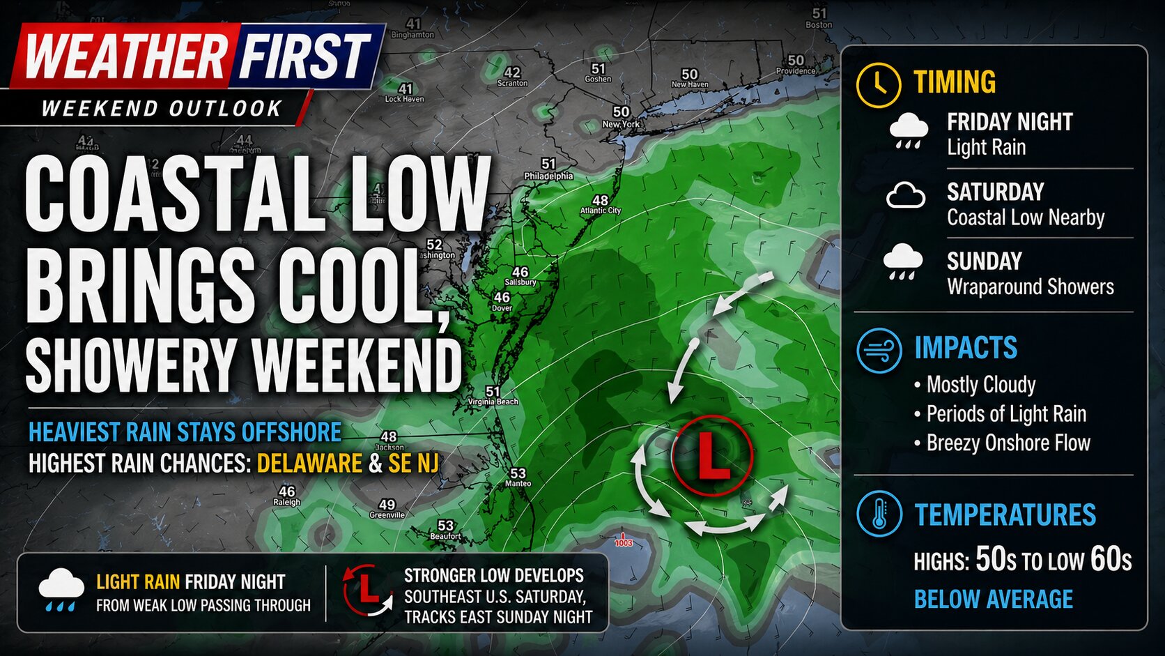
    A pair of low pressure systems will impact the Delmarva region from Friday night through the weekend, bringing periods of light rain, gusty onshore flow, and a return to below-average temperatures.

    The first system, a weak area of low pressure, is expected to pass through the region Friday night. This will deliver a quick shot of light precipitation, with most areas seeing minimal rainfall totals. Impacts from this initial system appear limited, but it sets the stage for a more complex setup heading into Saturday.

    Attention then turns to a stronger system developing to the south. A deep upper-level trough digging across the Midwest and Gulf Coast states will help spawn a more organized area of low pressure over the southeastern United States. This system is forecast to lift north toward the Mid-Atlantic during the day Saturday before tracking offshore by Saturday night into Sunday.

    For Delmarva, this track is critical. Current trends suggest the heaviest rainfall will remain offshore, particularly east of the coastline. However, wraparound moisture on the backside of the system will likely spread clouds and occasional rain back into the region, especially across Delaware and far southeastern New Jersey where rain chances are highest.

    While this will not be a washout for most, periods of light rain and persistent cloud cover are expected through at least part of the weekend. The combination of onshore flow and thick cloud cover will also keep temperatures suppressed, with highs generally stuck in the 50s to low 60s, well below late-April normals.

    Overall, the weekend will feature more clouds than sun, with occasional showers and a cool, damp feel. While beneficial rainfall is possible in spots, the bulk of the system’s moisture is expected to remain just offshore, limiting more widespread or heavier totals across the region.

  • Historic Winter Storm to Hammer Delmarva and South Jersey; Thundersnow Possible Tonight

    Historic Winter Storm to Hammer Delmarva and South Jersey; Thundersnow Possible Tonight

    A major and potentially historic winter storm is set to bring crippling snowfall, blizzard conditions, damaging winds, and significant coastal flooding to the Delmarva Peninsula and southern New Jersey through Monday.

    The storm is rapidly intensifying as it tracks northeast along the Mid-Atlantic coast. Forecast guidance continues to show the low deepening dramatically offshore, potentially reaching near 970 millibars. This strengthening coastal system will place Delmarva and South Jersey in a prime zone for heavy snow, strong winds, and dangerous conditions.

    Heavy Snow Becoming Intense This Evening

    Light precipitation is already spreading into the region, but colder air will quickly take over this afternoon and evening. Any early rain or mix will transition to all snow as the heaviest precipitation moves in.

    Snowfall rates are expected to exceed 2 inches per hour at times tonight, especially across Delaware and southern New Jersey. Widespread totals of 1 to 2 feet are expected across much of Delmarva, with locally higher amounts possible near the Delaware and New Jersey coasts where banding sets up.

    Southern New Jersey is expected to see some of the heaviest snowfall, particularly along the coastal counties where intense snow bands may persist for several hours.

    Thundersnow Possible Tonight

    With very strong upward motion in the atmosphere and intense snow bands developing, thundersnow is possible tonight across parts of Delmarva and southern New Jersey. This rare phenomenon occurs when lightning and thunder develop within heavy snow bands, often signaling extremely heavy snowfall rates and rapidly deteriorating visibility.

    If thundersnow develops, snowfall rates could briefly become even more intense, leading to near whiteout conditions.

    Blizzard Conditions and Life-Threatening Travel

    As the storm strengthens offshore tonight, winds will ramp up significantly. Northeast winds of 20 to 35 mph will shift north and northwest into Monday, with gusts of 35 to 45 mph inland and up to 60 mph along the coast.

    The combination of heavy, wet snow and strong winds will produce blowing and drifting snow, sharply reduced visibility, and potentially impossible travel conditions. Blizzard Warnings are in effect across all of Delaware and all of New Jersey.

    Even outside of strict blizzard criteria, travel is expected to become extremely dangerous Sunday night into early Monday. Residents are strongly urged to avoid travel once conditions worsen.

    Power Outages Likely

    Snow will initially be heavy and wet, sticking to trees and power lines. Combined with strong wind gusts, this increases the risk for scattered power outages across the region.

    Coastal Flooding Expected Tonight

    In addition to snow and wind, widespread coastal flooding is expected during tonight’s high tide cycle.

    Strong onshore winds will push water into the back bays and along the Atlantic coastline of southern New Jersey and Delaware. Moderate coastal flooding is likely, with some locations potentially reaching major flood stage, especially from Ocean County, New Jersey southward through Sussex County, Delaware.

    Coastal Flood Warnings remain in effect for Atlantic and Cape May Counties in New Jersey and for Kent and Sussex Counties in Delaware.

    Another round of minor to moderate flooding may occur Monday as ocean swells remain elevated, even as winds gradually shift offshore.

    No Tidal Flooding for Maryland Eastern Shore Rivers

    While Atlantic coastal areas face significant flooding concerns, tidal flooding is not expected along the tidal Maryland Eastern Shore waterways.

  • Major Nor’easter to Bring Blizzard Conditions to Delmarva Sunday into Monday

    Major Nor’easter to Bring Blizzard Conditions to Delmarva Sunday into Monday

    A powerful late-February nor’easter is expected to significantly impact the Delmarva Peninsula from Sunday afternoon through Monday evening, bringing heavy snow, strong winds, and potentially dangerous travel conditions.

    This storm will rapidly intensify off the Mid-Atlantic coast, creating a period of heavy snowfall and localized blizzard conditions across coastal Delaware and portions of inland Sussex County.

    Heavy Snow and Strong Winds

    Snow is expected to overspread Delmarva Sunday afternoon, becoming heavy at times Sunday night into early Monday. Snowfall rates could exceed one to two inches per hour during the height of the storm.

    Total accumulations across parts of the peninsula could reach significant levels, especially closer to the Delaware beaches, where blowing and drifting snow may greatly reduce visibility.

    In addition to heavy snowfall, strong northeast winds are expected to increase through Sunday night. Wind gusts between 40 and 60+ mph could create whiteout conditions, particularly along coastal areas. These winds will also lead to significant drifting, making roads impassable in some locations.

    Travel Could Become Extremely Dangerous

    The combination of heavy snow and strong winds may produce localized blizzard conditions across coastal Delmarva. Visibility could drop below a quarter mile at times, especially during peak snowfall rates.

    Travel is expected to become very difficult Sunday night into Monday. Both the Monday morning and evening commutes could be heavily impacted if conditions worsen as expected.

    Residents are urged to limit travel to emergencies only. If travel is unavoidable, motorists should carry a winter survival kit and be prepared for rapidly deteriorating conditions.

    Power Outages Possible

    Strong winds combined with heavy, wet snow could lead to scattered power outages across Sussex County and nearby coastal communities. Tree damage is possible, particularly where snowfall accumulates on limbs before peak wind gusts arrive.

    Coastal Concerns

    Moderate coastal flooding and beach erosion are also possible along the Delaware coastline, especially during times of high tide as strong onshore flow persists.

  • Periods of Rain Expected Across Delmarva Through the Weekend

    Periods of Rain Expected Across Delmarva Through the Weekend

    Residents across the Delmarva Peninsula should prepare for several rounds of rain as a series of weather systems move through the region from late Friday into early Sunday. While no significant flooding or severe weather is expected, the stretch will bring generally wet and mild conditions.

    The first system arrives late Friday as a weakening cold front moves into the Mid-Atlantic. This front is tied to an area of low pressure lifting north from the Great Lakes toward Quebec. Rain is expected to develop Friday afternoon and continue into Friday night. As the front weakens and gradually dissipates over the region, temperatures are not expected to drop noticeably, with little to no cold air pushing in behind it.

    A second, more impactful system follows on Saturday. A deepening upper-level trough moving south from Canada into the Great Lakes will help spawn a new surface low over the lower Mississippi River Valley. This low will track northeast, pushing a warm front northward across Delmarva on Saturday. As the warm front lifts through the region, rain coverage will increase and milder air will overspread the peninsula.

    Temperatures on Saturday may behave unusually, with some locations seeing their highest readings later in the day or even during the evening hours as warmer air moves in. Overnight temperatures may hold steady or even rise slightly in some areas. Overall, Saturday is expected to be a warm and wet day, with temperatures ranging from the upper 40s to the low 60s.

    Heavier rain is expected to move in later Saturday as an initial cold front crosses the region. While a brief rumble of thunder cannot be ruled out due to some elevated instability in the atmosphere, no severe weather is anticipated. Showers may linger Saturday night until a secondary cold front moves through on Sunday morning. Behind that front, winds will increase, but the chance of wind gusts reaching advisory levels remains low.

    There is higher confidence that Delmarva will see periods of rain from Friday afternoon through Sunday morning, though exact rainfall totals remain uncertain. Most guidance suggests at least a half inch of rain, with some models indicating localized totals between 1.5 and 2 inches. The probability of receiving one inch or more of rain is around 40 to 60 percent, while the chance of exceeding two inches is low.

    Rainfall is expected to fall over a 36 to 48 hour period with breaks between systems, reducing the risk of flooding. With mild temperatures in place leading into the weekend, any remaining ice in streams or rivers should have already melted, allowing water to drain efficiently. Confidence in rainfall totals and timing is expected to improve as the weekend approaches.

  • Multiple Rounds of Rain Expected Across Delmarva This Weekend

    Multiple Rounds of Rain Expected Across Delmarva This Weekend

    The Delmarva region is expected to see several rounds of rain as a series of weather systems move through the area from late Friday into Sunday morning. While the rain will be spread out over time, confidence is high that most locations will see wet conditions at some point during the weekend.

    The first round of rain arrives late Friday into Friday night as a weakening cold front crosses the region. This front is associated with an area of low pressure moving from the Great Lakes toward eastern Canada. Because the front is weakening as it approaches Delmarva, it is not expected to bring much of a temperature drop or colder air. Rain during this period should generally be light to moderate.

    A stronger system moves in on Saturday as a slow moving trough dives south from Canada into the Great Lakes. This will help develop a new area of low pressure over the Lower Mississippi Valley that tracks northeast toward the Mid Atlantic. A warm front is expected to lift through Delmarva Saturday morning, placing the region in a warmer and more humid air mass. Temperatures are forecast to rise into the 60s, which is mild for this time of year, though still a few degrees shy of daily records.

    Heavier rain is expected later Saturday into Saturday night as a cold front moves through the region. There may be enough instability in the atmosphere for a rumble of thunder, but severe weather is not expected. After the initial front moves offshore Saturday night, scattered showers may linger until a secondary cold front passes through on Sunday morning.

    Once the secondary front clears the area, winds will increase, but the chance of wind gusts reaching advisory levels remains low. Overall, rainfall will be spread out over a 36 to 48 hour period with breaks between rounds.

    Forecast confidence is high that rain will occur, but exact rainfall totals remain uncertain. Most guidance suggests at least a half inch of rain, with some models indicating localized totals between 1.5 and 2 inches. The probability of receiving one inch or more of rain sits around 30 to 50 percent, while the chance of exceeding two inches is low.

    Despite the potential for moderate rainfall, flooding concerns remain minimal. The rain will fall gradually rather than all at once, and recent mild temperatures should have eliminated any lingering ice in creeks or rivers, allowing water to drain efficiently.

    More confidence in rainfall totals is expected as the weekend approaches, but residents across Delmarva should be prepared for several periods of rain from Friday afternoon through Sunday morning.

  • High Winds And Cooler Temps Follow Behind Cold Front This Weekend

    High Winds And Cooler Temps Follow Behind Cold Front This Weekend

    A strong cold front moving through the Northeast is expected to bring a period of gusty winds through Sunday night, with the highest wind gusts occurring in the wake of the front. Widespread gusts of 40 to 55 mph are likely across much of the Mid-Atlantic and interior Northeast, including Pennsylvania, New Jersey, New York, and New England. Stronger gusts in the 55 to 65 mph range are possible across parts of upstate New York and areas downwind of the Great Lakes, where the pressure gradient will be strongest. Along the coast, especially across New Jersey, Long Island, and southern New England, gusts may exceed 50 mph, increasing the risk for downed trees, power outages, and travel disruptions.

    Here is a break down per state in the region…

    Delaware:
    Strong winds are expected behind the cold front, with peak gusts generally ranging from 45 to 55 mph statewide. The highest gusts are most likely along the coast and across the Delmarva Peninsula, where marine influence and a tighter pressure gradient could push isolated gusts slightly higher. These winds may lead to scattered power outages and difficult travel, especially on bridges and causeways.

    Maryland:
    Widespread gusts of 45 to 55 mph are forecast across much of Maryland, including the I-95 corridor from Baltimore to Washington. Western Maryland could see locally stronger gusts approaching 55 to 60 mph, particularly in higher elevations and along exposed ridgelines. The combination of saturated soils and strong winds may increase the risk for downed trees and power lines.

    Virginia:
    Much of northern and central Virginia can expect wind gusts between 40 and 50 mph, with higher gusts of 50 to 55 mph possible across eastern Virginia and along the Chesapeake Bay. Coastal and tidal areas may experience the strongest winds as colder air surges in behind the front. Impacts may include isolated power outages, difficult travel for high-profile vehicles, and minor coastal concerns.

  • Major Storm System Across The Country Next Week: High Winds & Severe Weather

    Major Storm System Across The Country Next Week: High Winds & Severe Weather

    A major storm system is on the way across the Central Plains towards the East Coast bringing a plethora of heavy rain, severe weather and high winds. A severe weather risk from Tuesday-Wednesday where approximately 60 million people are in the threat regions for damaging winds, large hail, and the threat for tornadoes

    The Storm Prediction Center center highlighting a 30% severe weather risk across Northern Lousiana towards Western Kentucky with a large 15% risk from Illinois towards the Gulf Coast Tuesday. Extending into the Mid-Atlantic and the Southeast US on Wednesday. SPC Meteorologist Jeremy Kerr had this to say about the storm threat next week.

    ” Spread typical at this extended time frame (day 5) lingers among the
    various model output concerning the sub-synoptic, and even synoptic,
    details across the southeastern Great Plains through Ohio Valley and
    Southeast, which may considerably impact the severe weather risk
    area and potential. However, the medium-range guidance depicts an
    environment at least conditionally supportive of an organized severe
    weather event, including potential for a few strong tornadoes and
    damaging straight line winds.

    It is possible, but perhaps a bit more uncertain, that this could
    continue across parts of the southern and middle Atlantic Seaboard
    on Wednesday.”

    While the threat for severe weather isn’t enough, this system will be quite the wind maker as well. A powerful Jetstream combined with a strong low level Jetstream of 60-80kts. Providing a lot of wind energy down towards the surface. And with the presence of thunderstorms, that wind threat may increase even more going forward.

    As of now winds gusting 45-60 MPH are not out of the question come Wednesday which may lead to more episodes of down trees, and sporadic power outages. In the event of thunderstorms are in the mix, winds could become locally stronger bringing some of those powerful winds down to the surface.

  • Windy Conditions Moving In For Wednesday: Powerful New England Storm System

    Windy Conditions Moving In For Wednesday: Powerful New England Storm System

    VALID: WEDNESDAY JAN 29TH @ 8AM

    Winds are beginning to intensify along the shoreline as a cold front steadily progresses through the region over the next several hours. Current observations indicate wind gusts already reaching up to 40 mph in some areas, with conditions expected to worsen as the front advances. By tomorrow, winds are forecast to strengthen further as the pressure gradient tightens, resulting in gusts up to 45 mph—nearing Wind Advisory thresholds.

    This increase in wind activity is tied to the influence of a strong low-pressure system currently diving southward from Canada. This system will bring widespread impacts, including areas of heavy snow squalls expected to develop across portions of upstate Pennsylvania and New York on Wednesday. Additionally, the intensification of the low-level jet stream, which is projected to reach speeds between 50 and 80 mph, will contribute to widespread gusty conditions across the mid-Atlantic and Northeast.

    Regions surrounding the Chesapeake Bay and Northern Maryland are expected to experience even stronger winds as the cold front and low-pressure system interact. In particular, wind acceleration along the eastern slopes of the Appalachian Mountains could produce gusts reaching as high as 50 mph. Higher-elevation areas, including parts of Western Maryland and Northern Virginia, where High Wind Warnings are in effect, are likely to encounter gusts exceeding 60 mph at times, presenting potential hazards to outdoor activities, infrastructure, and travel.

    Residents across the affected areas are encouraged to remain vigilant and secure loose objects outdoors, as these strong winds could lead to localized damage and power outages. Travelers should exercise caution, particularly in high-profile vehicles, due to the risk of crosswinds. Stay tuned to local forecasts for updates as this dynamic weather system unfolds.

    Wind Advisory In Effect From 11AM Weds – 6PM Weds

    …WIND ADVISORY IN EFFECT FROM 11 AM TO 6 PM EST WEDNESDAY…

    * WHAT…West winds 20 to 30 mph with gusts up to 50 mph expected.

    * WHERE…Portions of DC, central, north central, northeast, and

    northern Maryland, and northern Virginia.

    * WHEN…From 11 AM to 6 PM EST Wednesday.

    * IMPACTS…Gusty winds will blow around unsecured objects. Tree

    limbs could be blown down and a few power outages may result.

    PRECAUTIONARY/PREPAREDNESS ACTIONS…

    Winds this strong can make driving difficult, especially for high

    profile vehicles. Use extra caution.

  • Winter Storm Safety: Delaware State Police and DelDOT Issue Snow Safety Tips

    Winter Storm Safety: Delaware State Police and DelDOT Issue Snow Safety Tips

    Dover DE:

    As the snow continues to fall across Delaware, state officials are emphasizing safety measures for all residents. The Delaware State Police have issued a series of guidelines aimed at keeping motorists safe during the winter weather:

    • Stay Home if Possible: If you can avoid travel, do so. Conditions can be unpredictable and hazardous.
    • Drive Cautiously: For those who must travel, slow down, keep a safe distance from other vehicles, and ensure your vehicle is free of snow and ice to prevent accidents.
    • Emergency Preparedness: Carry an emergency kit in your car with items like blankets, a flashlight, food, and water. Check road conditions via official channels before setting out.
    • Respect Snow Plows: Do not attempt to pass or crowd snow removal vehicles. The Delaware Department of Transportation (DelDOT) crews are diligently working to clear the roads, and they need space to operate safely.

    DelDOT has expressed gratitude towards their crews for their relentless efforts during the storm, urging the public to assist by not crowding the plows.

    The Delaware Emergency Management Agency (DEMA) also reminds everyone to check on neighbors, particularly the elderly or those who might need assistance during this time.

    With these safety tips in mind, Delawareans are encouraged to take extra precautions as the winter weather persists. Your safety, and the safety of those around you, is paramount.

  • Wash, Rinse, Repeat. Another High Wind Event On The Way

    Wash, Rinse, Repeat. Another High Wind Event On The Way

    Although the next storm system is another big one moving through the same areas as the last one, this one will not have that extreme punch like this one will. Still will be a nuisance to say the least.

    Strong winds will be a issue once again but thankfully we will NOT see those hurricane force wind gusts like we did but still in the higher end of the advisory category. Winds during the later overnight hours Friday into Saturday morning will gust 40-50 MPH on average but at times could gust 55 or higher especially near the coastlines. Which once again can lead to sporadic power outages and tree damage.

    Rainfall will once again will be a problem but not a extreme problem. A lot less rain is expected with this storm. Most areas will see upwards to a inch of rain but with saturated grounds, sporadic flooding is possible.

    Coastal Flooding will be a issue yet again with the New Moon still in play creating higher than normal tide cycles. At this time most tidal gauge forecasts are showing minor to moderate levels of tidal flooding Friday Night. Main flooding concerns will once again be in the Chesapeake and the mouth of the Delaware River.

  • *** Hybrid Storm Expected This Weekend / Wednesday Update ***

    *** Hybrid Storm Expected This Weekend / Wednesday Update ***

    Confidence continues to increase for some sort of sub-tropical in nature storm system to develop along a stalled out frontal boundary off the coast of Florida and Georgia. With a strong area of high pressure it place towards New England, this will allow this system to intensify and move in towards the Carolina coastlines late Friday through Sunday.

    Overspreading heavy rain, gusty winds, and coastal flooding are all expected this weekend. Especially on Saturday when the conditions are expected to be the worst out of this storm. Whether this storm will be tropical in nature or not, impacts are going to be felt like a stronger nor’easter we would see in the winter months.

    Rain will begin to overspread the region beginning during the overnight hours on Friday and picking up in intensity on Saturday. Rain will be heavy at times with many operational and ensemble mean totals of 2-5 inches are expected over the weekend. With an area of high pressure to north, a strong pressure gradient will setup with constant strong onshore winds from the east and northeast. Sustained winds of 20-30 MPH with gusts 40-50 mph at times, will help generate waves offshore 10-20 feet. Near the coast, we are looking at swells generating 7-12 feet.

    With some of the the tide gauge forecasts as of now showing areas along the Atlantic Ocean and Inland Bay regions for Minor to even Moderate coastal flooding during the high tide cycle Saturday afternoon. I worry for the Inland Bays a lot more with all the water being forced with no where to go given how big the swells will be with the strong long fetched onshore winds.

    It’s pretty definitive at this point that we have a coastal storm on the way, it’s just a matter of how much rain will be associated with this system, and if it happens to be tropical or not. Or even a combination of both being a hybrid sub-tropical system. More details will be provided as the week goes on.

  • Hybrid Coastal Storm Impacting Delmarva This Weekend

    Hybrid Coastal Storm Impacting Delmarva This Weekend

    With the potential hybrid storm coming this weekend, not only heavy rain and gusty onshore winds are a problem, these are going to be some big waves. Moderate coastal flooding is on the table for Saturday. With onshore winds of 40-50 mph wind gusts generating waves 10-20 feet offshore. That’s going to be driving water hard to the coastal locations. Inland bays will be the bigger issues where water will not have any place to go.

    We still have days to go to see the full extent of details but the consistency in model guidance is very good with this one so far. Whether this will be a tropical system or a nor’easter, this will be bringing heavy rains, gusty winds, and coastal flooding.

  • Strong To Severe Thunderstorms Possible Saturday | Brand New Tornado Forecast Tool

    Strong To Severe Thunderstorms Possible Saturday | Brand New Tornado Forecast Tool

    Storm Threats For Saturday

    We are getting closer and closer to our typical Severe Weather Season here on the shore. And we get a bit of a taste for it on Saturday. Now here’s the setup we are looking at.

    First off we have a fairly strong area of low pressure moving across the Great Lakes region with a strengthening mid level Jetstream across the Mid-Atlantic States. That’s the first set of ingredients for the storm setup for tomorrow.

    Now storm formation will be isolated in nature based on the latest high resolution model guidance. One thing is for sure we got the warmer temperatures and bit of surface moistures with dew points getting into the 60’s. So it’s going to be a little bit muggy out there by the early afternoon hours.

    Now we will see ample instability and wind shear across the region before our cold front arrives during the evening hours. MLCAPE (a product used to measure instability) showing values in the moderate instability category which is very crucial for thunderstorm development. Not to mention with the decent amount of instabilty, mid level lapse rates are fairly steep as well. Anytime we get Lapse Rates in the mid levels over 7C/km, that increases our hail threat just a bit with the colder air higher into the atmosphere. This is why we have a bit of a higher threat for seeing quarter size hail in storms that may develop. Not to mention we have some decent bulk shear (wind shear in a storm environment). 50-60kts is more than plenty to get a mix of line segments or even a couple of isolated supercell thunderstorms.

    Now in production for a little while, we have been working very hard at developing to really narrow down tornado threats in a 0-10 scale (0-100%). We are testing the waters on this one since there is a little bit of a tornado threat going into tomorrow. our TEHI product showing a level 1-2 threat out of 10 for tornadoes here on the shore. meaning storms will have a 10-20% chance of producing a tornado. Low level environment showing sufficient turning in the lowest levels which is very important for tornadogenisis.

    One limiting factor for storms tomorrow is the time of year we are in. Our coastal water temperatures do play a role in our storm threats with them being in the upper 40’s. This can create some stable air near the surface and cause storms to climb upscale and scrapping any tornado threat all together.

  • Wind Advisories & Winter Weather Advisories for Saturday

    Wind Advisories & Winter Weather Advisories for Saturday

    ...WIND ADVISORY IN EFFECT FROM 10 AM SATURDAY TO 1 AM EST
    SUNDAY...
    
    * WHAT...Northwest winds 20 to 30 mph with gusts up to 50 mph
      expected.
    
    * WHERE...Portions of New Jersey, southeast Pennsylvania, the
      eastern shores of Maryland and Delaware.
    
    * WHEN...From 10 AM Saturday to 1 AM EST Sunday.
    
    * IMPACTS...Gusty winds could blow around unsecured objects.
      Tree limbs could be blown down and a few power outages may
      result.
    
    * ADDITIONAL DETAILS...Strong winds develop late Saturday morning
      and continue into the afternoon. There may be a lull Saturday
      evening before increasing once again.
    
    ----------------------------------------------------------------
    ...WINTER WEATHER ADVISORY IN EFFECT FROM 6 AM TO 7 PM EST
    SATURDAY...
    
    * WHAT...Snow expected. Total snow accumulations of 1 to 3
      inches. Winds gusting as high as 45 mph.
    
    * WHERE...Portions of northern New Jersey, southeast Pennsylvania
      and northern Delaware.
    
    * WHEN...From 6 AM to 7 PM EST Saturday.
    
    * IMPACTS...Plan on slippery road conditions. Gusty winds could
      bring down tree branches.
  • Major Coastal Storm Friday-Saturday

    Major Coastal Storm Friday-Saturday

    High Res Window Model Showing Major Coastal Low Over Delmarva

    We have been talking about this scenario throughout the week about a major storm system will be developing in the Eastern half of the nation. An area of low pressure will be rapidly developing from the Gulf States and runs parallel through the Mid-Atlantic states during the morning hours on Saturday.

    Large Trough In the Eastern US

    Phasing of the Northern Jet and the Sub-Tropical Jet will set the stages of a potential Bomb Cyclone (air pressure that drops more than 24mb’s in 24 hours) to develop. By the time this storm system moves north of New England we could be looking at some serious low pressures by Greenland.

    Depending on the placement of this area of low pressure will determine if we are in the path of the powerful low level Jetstream to setup. The blend solution has the area of low pressure going right over the Delmarva region keeping those powerful winds off of our coasts. But if the low positions further west, this will allow for a short term duration of strong winds exceeding 50 mph at times.

    Low Level Jetstream 90-100kts offshore

    To add more dynamics to the mix, cold air will be crashing on the northwest side of the storm which we may see a burst of snow on the backside during the evening hours. Any snow that does fall will have a extremely difficult time accumulating here on the shore. It’s a matter of how quickly can those temperatures crash on that backside of the storm. And the position of the low. If we have a further east solution like the NAM3km, then our chances are high but I have that one as my outlier as of now. I’m leaning more with the HRW-ARW with the further west solution overall.

  • Strong Thunderstorms Possible This Evening

    Strong Thunderstorms Possible This Evening

    With the extremely warm temperatures on this March day here on the shore, we have a strong cold front on the move this evening. With barely any instability in place today, this storm threat is strong shear dominate. We have the chance of some storms that could reach severe limits during the evening hours today. Computer guidance has been hinting at a thin squall line to develop along the front with already very strong surface winds expected today.

    Slight Risk of Severe Weather For Northern Delmarva and Northern Maryland

    The biggest driver for today’s Slight Risk of Severe Weather is the very strong low level shear and steep lapse rates. With strong winds fairly close to the surface and with a strengthening low level jet to 60 knots, when that front arrives some of those stronger winds aloft will be brought down to the surface.

    Steep Low Level Lapse Rates indicating some great mixing of the stronger winds aloft to be brought down to the surface.

    Anytime you see Lapse Rates greater that 7.5 in the lowest levels, that’s the perfect case scenario for a damaging wind potential. Damaging winds are really the only threat with today’s setup. Tornado threat is very low today because the wind direction throughout the atmosphere is very linear. Tornadoes need turning wind form the surface on up.

  • Growing Concerns For A High Wind Event Thursday Night-Friday

    Growing Concerns For A High Wind Event Thursday Night-Friday

    Growing concerns that we may be dealing with a high wind event evolving during the overnight hours on Thursday into the day on Friday. All thanks to a rapidly developing storm system from the Central Plains that will be driving a cold front through the Eastern Half of the nation. Not to mention the very warm temperatures that will be following the upcoming event as well.

    850mb Winds: Low Level Jetstream

    The main driver for the strong winds we are expecting is the enhancement of the nocturnal low level Jetstream which sits about 5000 feet above the surface. While this area of low pressure continues to strengthen as it crosses into the Great Lakes, the gradient between this area of low pressure and a strong high pressure system off the East Coast will really start enhancing those winds. Forecast models have been quite bold with 70-80kts (80-90 mph) low level jet at 5000 feet which is very strong. Now keep in mind, those winds are pretty high off the ground and unlikely we will see those reaching the surface. With the aid of falling precipitation, we will see some of those stronger winds above he surface to mix down.

    With the strong wind energy with that low level jet, no surprise we can see wind gusts 40-55 mph at the surface during the nighttime hours as the cold front edges closer. Winds of this speed can knock down some tree limbs and cause some sporadic power outages at times. Gusty winds will continue throughout the day on Friday even behind the front.

  • High Wind Event With Coastal Flooding Concerns Sunday Night

    High Wind Event With Coastal Flooding Concerns Sunday Night

    Not only we have to deal with some heavy rainfall, a little bit of snow for the northern areas of Delmarva and the Maryland Western Shore. There’s an event that is sleeping under the radar that has my full attention. When that low starts dropping below 990mb, that low level jet stream is very strong being pulled into this surface low.

    70-80kt Winds at 850mb ( Low Level Jet)

    Anytime I start seeing winds at 5000ft getting over 60kts, I get a bit uneasy in the damaging wind department. This is a long fetch stream of onshore winds we are talking about from the Gulf Stream. There is going to be a lot of wind energy pushing on the east side of this low. And it’s all onshore flow too. There’s more issues with this as well.

    Winds at the surface are showing widespread wind gusts of 40-60 mph from the east and southeast. Another problem surfaces as well. We have a high tide cycle that’s expected during the evening hours Sunday Night. To add more salt in the wound, this weekend is a full moon as well. So take 40-60mph surface winds, plus onshore flow, plus a high tide cycle, and a full moon, it’s not going to be a fun time for a coastal locations this weekend. Strongest winds appear to be in a window from 8pm Sunday until 4am Monday.

    Already a few tidal forecast in the region showing Moderate Flood Stage forecasts like this one in Crisfield. So we really got to watch our coastal regions Sunday night for flooding concerns.