Tag: wind damage

  • Severe Weather Awareness Week: Day 3 “Severe Thunderstorms & Hail”

    Severe Weather Awareness Week: Day 3 “Severe Thunderstorms & Hail”

    Severe thunderstorms are officially defined as storms that are capable of producing hail that is an inch or larger or wind gusts over 58 mph. Hail this size can damage property such as plants, roofs and vehicles. Wind this strong is able to break off large branches, knock over trees or cause structural damage to trees. Some severe thunderstorms can produce hail larger than softballs or winds over 100 mph, so please pay attention to the weather so you know when severe storms are possible. Thunderstorms also produce tornadoes and dangerous lightning; heavy rain can cause flash flooding.

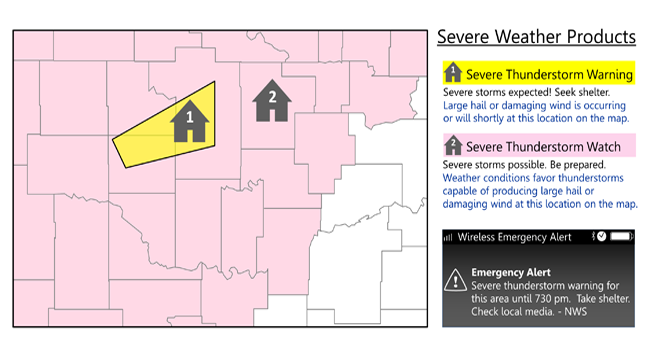
    Do you know the difference between a National Weather Service Severe Thunderstorm Watch and a Severe Thunderstorm Warning? Check your knowledge below.

    Severe Thunderstorm Watch: Be Prepared! Severe thunderstorms are possible in and near the watch area. Stay informed and be ready to act if a severe thunderstorm warning is issued. The watch area is typically large, covering numerous counties or even states.

    Severe Thunderstorm Warning: Take Action! Severe weather has been reported by spotters or indicated by radar. Warnings indicate imminent danger to life and property. Take shelter in a substantial building. Get out of mobile homes that can blow over in high winds. Warnings typically encompass a much smaller area (around the size of a city or small county) that may be impacted by a large hail or damaging wind identified by an NWS forecaster on radar or by a trained spotter/law enforcement who is watching the storm.

    Find out what you can do before severe weather strikes. Preparation is key to staying safe and minimizing impacts.

    • Be Weather-Ready: Check the forecast regularly to see if you’re at risk for severe weather. Listen to local news or a NOAA Weather Radio to stay informed about severe thunderstorm watches and warnings. Check the Weather-Ready Nation for tips.
    • Sign Up for Notifications: Know how your community sends warning. Some communities have outdoor sirens. Others depend on media and smart phones to alert residents to severe storms.
    • Create a Communications Plan: Have a family plan that includes an emergency meeting place and related information. Pick a safe room in your home such as a basement, storm cellar or an interior room on the lowest floor with no windows. Get more ideas for a plan at: https://www.ready.gov/make-a-plan
    • Practice Your Plan: Conduct a family severe thunderstorm drill regularly so everyone knows what to do if a damaging wind or large hail is approaching. Make sure all members of your family know to go there when severe thunderstorm warnings are issued. Don’t forget pets if time allows.
    • Prepare Your Home : Keep trees and branches trimmed near your house. If you have time before severe weather hits, secure loose objects, close windows and doors, and move any valuable objects inside or under a sturdy structure.
    • Help Your Neighbor: Encourage your loved ones to prepare for severe thunderstorms. Take CPR training so you can help if someone is hurt during severe weather.

    Find out what you can do when severe weather strikes. Acting quickly is key to staying safe and minimizing impacts.

    • Stay Weather Ready: Continue to listen to local news or a NOAA Weather Radio to stay updated about severe thunderstorm watches and warnings.
    • At Your House: Go to your secure location if you hear a severe thunderstorm warning. Damaging wind or large hail may be approaching. Take your pets with you if time allows.
    • At Your Workplace or School: Stay away from windows if you are in a severe thunderstorm warning and damaging wind or large hail is approaching. Do not go to large open rooms such as cafeterias, gymnasiums or auditoriums.
    • Outside: Go inside a sturdy building immediately if severe thunderstorms are approaching. Sheds and storage facilities are not safe. Taking shelter under a tree can be deadly. The tree may fall on you. Standing under a tree also put you at a greater risk of getting struck by lightning.
    • In a Vehicle: Being in a vehicle during severe thunderstorms is safer than being outside; however, drive to closest secure shelter if there is sufficient time.

    What should you do when the lightning and thunder stops and it looks likes the severe thunderstorm is over?

    • Stay Informed: Continue listening to local news or a NOAA Weather Radio to stay updated about severe thunderstorm watches and warnings. More severe thunderstorms could be headed your way.
    • Contact Your Family and Loved Ones: Let your family and close friends know that you’re okay so they can help spread the word. Text messages or social media are more reliable forms of communication than phone calls.
    • Assess the Damage: After you are sure the severe weather threat has ended, check your property for damages. When walking through storm damage, wear long pants, a long-sleeved shirt and sturdy shoes. Contact local authorities if you see power lines down. Stay out of damaged buildings. Be aware of insurance scammers if your property has been damaged.
    • Help Your Neighbor: If you come across people that are injured and you are properly trained, if needed, provide first aid to victims until emergency response team members arrive.
  • Remembering Superstorm Sandy: 12 Years Since Devastation and Resilience in the Mid-Atlantic

    Remembering Superstorm Sandy: 12 Years Since Devastation and Resilience in the Mid-Atlantic

    Today marks the 12th anniversary of Superstorm Sandy, one of the most destructive and unique storms to ever impact the eastern United States. Known for its unparalleled size and intensity, Sandy left a trail of devastation, particularly in the Mid-Atlantic and Delmarva regions. Its unprecedented combination of coastal flooding, record-breaking storm surges, and extreme winds wreaked havoc on communities, reshaping the region’s coastlines and lives.

    Superstorm Sandy: A Perfect Storm of Unusual Forces

    Superstorm Sandy began as a late-season hurricane in the Caribbean, following a northward path typical of Atlantic storms. But on October 29, 2012, Sandy took an unprecedented turn toward the U.S. mainland, merging with an approaching cold front. This merger transformed it into a hybrid system—a unique blend of tropical and extratropical forces—which vastly intensified its size, creating a sprawling wind field that spanned over 1,000 miles.

    Sandy’s unusually broad reach extended its impacts from the southeastern United States to the Canadian border, making it one of the largest and most impactful storms to strike the region. As it approached the coast, the collision of tropical moisture with cold, dry air from the north fueled its power, creating what meteorologists would call a “storm within a storm.” This rare dynamic made Sandy both catastrophic and unforgettable, even by hurricane standards.

    The Delmarva Impact: Coastal Flooding, Record Surge, and Utter Devastation

    Few places experienced Sandy’s wrath like the coastal communities of the Delmarva Peninsula. High tides coincided with Sandy’s powerful surge, creating unprecedented water levels. Flooding inundated roads, homes, and businesses, reaching areas far beyond the typical flood zones. Entire neighborhoods were submerged, with water damage reshaping landscapes and displacing families for weeks or even months.

    Record surges brought water to levels never before seen, breaching sea walls and transforming roads into rivers. Wind gusts reaching hurricane strength lashed the region, snapping trees, toppling power lines, and plunging thousands into darkness. Delmarva’s typically quiet coastal towns were left unrecognizable, and the economic impact was staggering. In total, Superstorm Sandy caused an estimated $70 billion in damages, with Delmarva and surrounding regions taking years to recover fully.

    The Wider Reach: Sandy’s Impact Across the Eastern United States

    The massive size of Superstorm Sandy meant its impacts went far beyond the coastal regions. Sandy’s far-reaching storm winds and extreme low pressure affected states up and down the East Coast, causing widespread flooding, power outages, and emergency declarations. Major urban centers from New York to Philadelphia and Washington, D.C., saw subways, highways, and neighborhoods flooded, with hospitals and critical infrastructure severely impacted.

    The “storm within a storm” effect created a system powerful enough to push storm surges and high winds far inland, affecting areas hundreds of miles from Sandy’s landfall. In addition to its human and structural toll, Sandy disrupted the national economy, resulting in billions in direct costs and lost productivity.

    A Legacy of Change: Building Resilience After Sandy

    Superstorm Sandy stands as a sobering reminder of the vulnerabilities of coastal communities in an era of rising sea levels and more extreme weather events. Since Sandy, cities along the East Coast have implemented a range of measures aimed at preventing future devastation. Infrastructure improvements, such as elevated roads and buildings, fortified seawalls, and improved stormwater management systems, have become priorities in many coastal areas.

    Sandy also transformed disaster preparedness in the region, with improved building codes, advanced forecasting systems, and faster, more coordinated emergency responses. These measures have made coastal communities better equipped for extreme storms, though Sandy’s legacy serves as a reminder of nature’s power.

    Remembering the Impact, Honoring the Resilience

    As we mark twelve years since Superstorm Sandy, memories of the unprecedented storm remain vivid for those who lived through it. The scars left by Sandy run deep, but so does the resilience of the communities that rebuilt. While nature’s power can never be fully controlled, Sandy’s story serves as a testament to the strength of those who confront and recover from its force.

    Today, we remember Sandy not just for the destruction it caused, but for the lessons it taught and the resilience it inspired across the eastern United States.

  • Severe Weather Threat For Thursday

    Severe Weather Threat For Thursday

    While we are now in the short term model guidance, we had a big shift in the timing of this event. On Tuesday many of the medium range model guidance showed this event to be extremely underwhelming and much later into the night. Now into Wednesday, we have pushed the timing up about 6-8 hours into the afternoon and evening hours on Thursday. That big shift in timing boosted our chances to match with the SPC’s Slight Risk of Severe Weather they had all week.

    A good agreement between the HRRR/RAP as well as the CAMS showing ample thunderstorm development across the Mid-Atlantic States. An increase in instability as well with dew points going into the lower 60’s. Storms should be developing from west to east from 2-10pm.

    With the main threat being wind damage within these storms. No surprise with the strong winds aloft and in the lower level Jetstream. Strong winds at 5000 feet of 60-70 kts giving ample speed shear for storms to produce some gusty downbursts. Using TEHI for the tornadic threat and the good news is once more, fairly low probabilities. TEHI values under 2 (20%) chance of these storms producing a tornado in this environment. Also when we take a look at the Updraft Helicity Streaks, there is very little if any which is good news for shows storms with potential rotation on the models.