Tag: warm up

  • Winter Takes a Break Across The Country But For How Long?

    Winter Takes a Break Across The Country But For How Long?

    The month of December brought well below average temperatures across much of the Mid-Atlantic region. Averaging as much as 4 to 6 degrees below normal. Putting impacts on energy costs already this early into the season but we are looking to see some relief on those heating bills over the next week. starting Tuesday, we flip the switch from being the freezer to being able to thaw out in a big way.

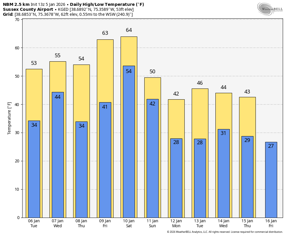
    Throughout the rest of this week, we are about to go from January weather to what i would say be ;ate October weather as we start cranking up to the 50s. Eventually towards the weekend we are even crossing the 60s threshold. Which is going to feel quite nice after being stuck every day in the 30s. But the real question lies, how long will this warm up will last?

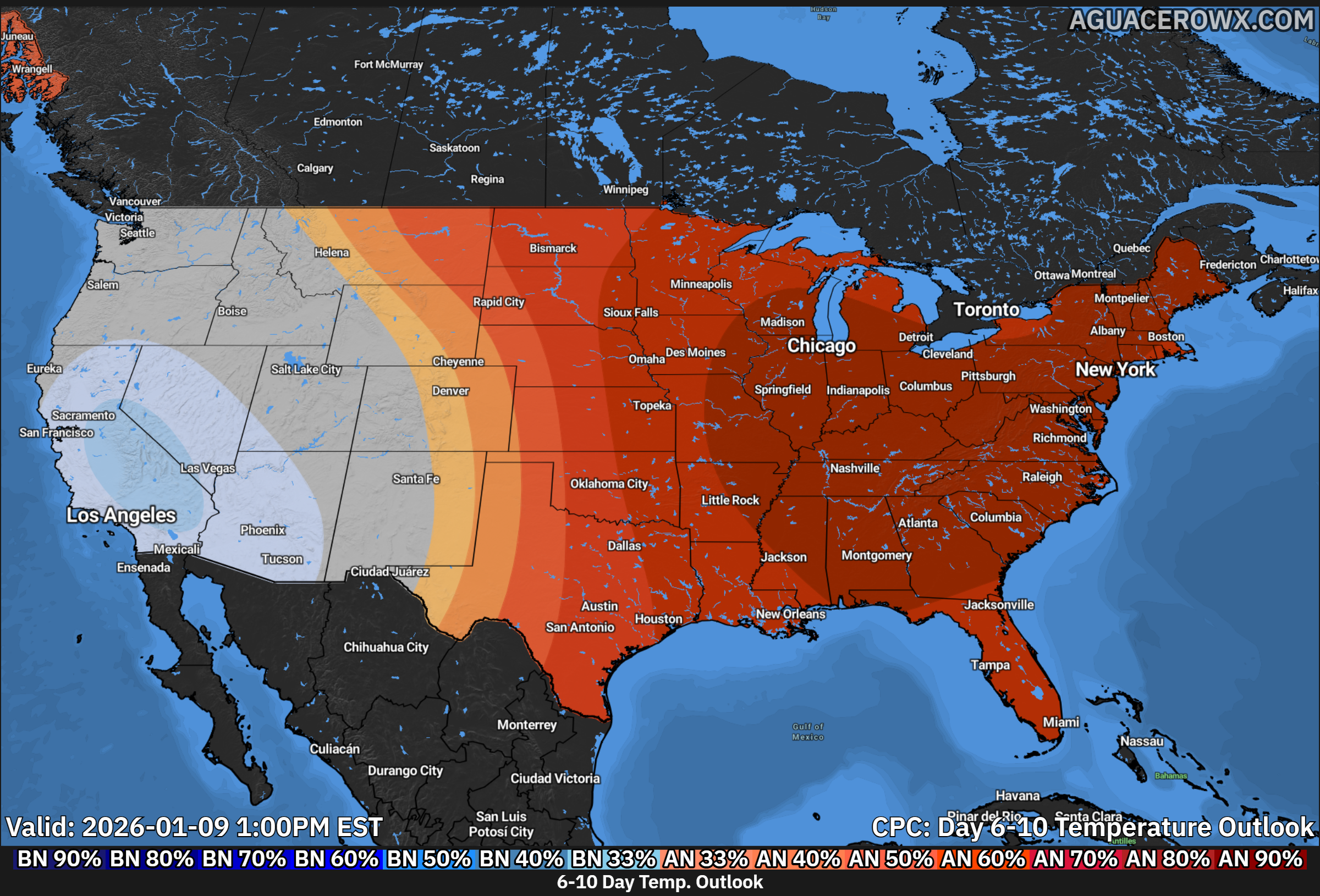
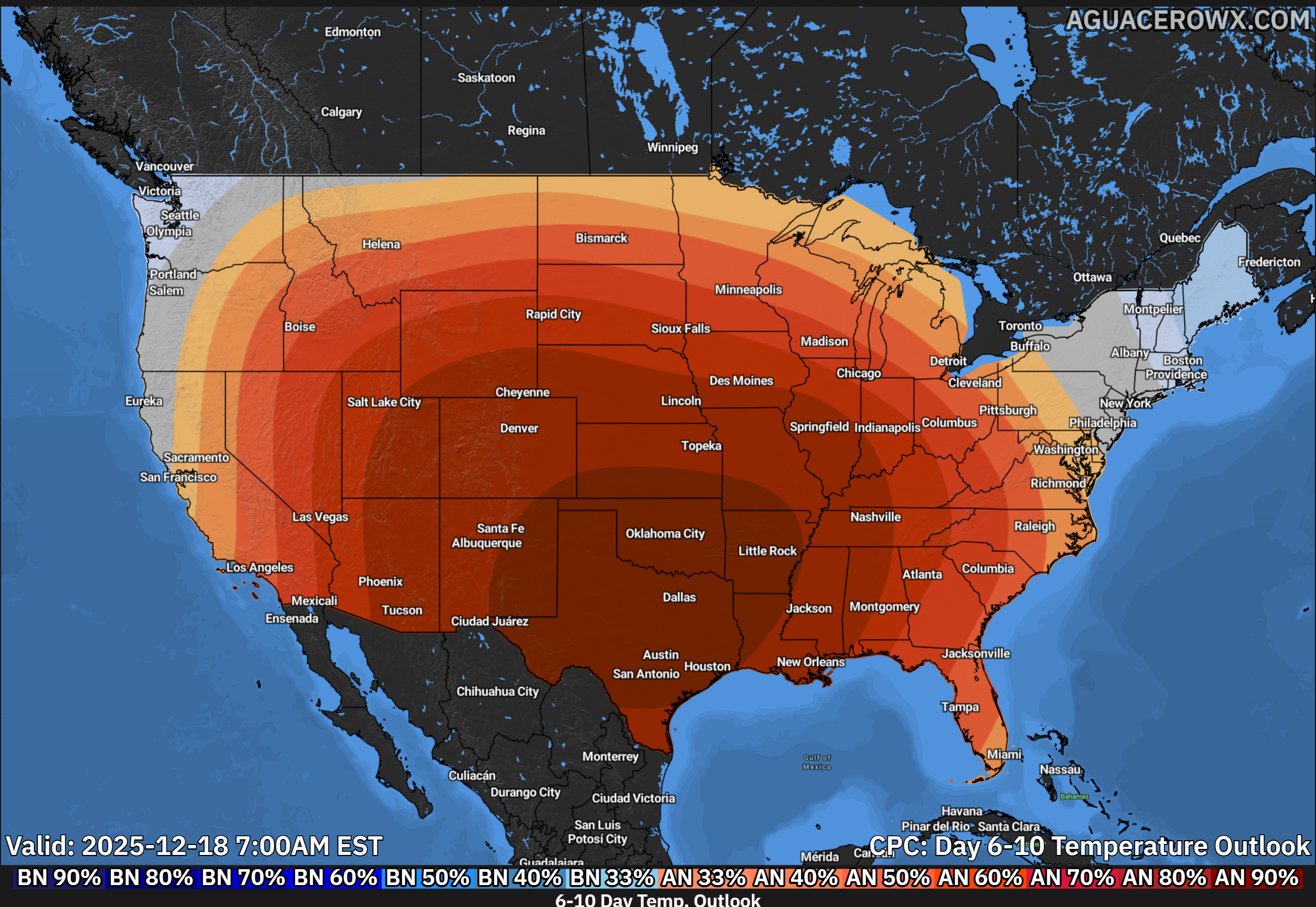
    It appears this will be a week long warm up with the warmest time frame appearing closer to the weekend with highs approaching the mid 60s. But also bring the onset of rain chances as a storm system will be lifting up towards the Great Lakes area. But towards the mid-month, signs are pointing to a return of the west coast ridge allowing for troughs to extend east towards the Mid-Atlantic to bring back more seasonable temperatures. Cold air intrusion would be possible after the 15th when this occurs so that’s when any snow chances would return as of now.

    Enjoy the warmth and thaw while it last as we still have a whole lot of winter to get through!

  • Widespread Warmth Expected Across Eastern U.S. in Mid-January Outlook

    Widespread Warmth Expected Across Eastern U.S. in Mid-January Outlook

    A strong signal for above-normal temperatures is shaping up across much of the eastern United States as we head into the January 8–12, 2026 timeframe, according to the latest 6–10 day temperature outlook issued by NOAA on January 2.

    The outlook shows a broad and confident area of above-average temperatures extending from the Mississippi Valley eastward to the Atlantic Coast. This includes the Midwest, Ohio Valley, Southeast, and much of the Mid-Atlantic and Northeast. In these areas, probabilities favoring above-normal temperatures range from 60% to as high as 90%, indicating a strong likelihood that temperatures will trend warmer than what is typical for early January.

    For the Mid-Atlantic region, including Delmarva, Maryland, and Pennsylvania, the signal is particularly robust. Persistent ridging in the upper atmosphere is expected to keep Arctic air bottled up well to the north, allowing milder air to dominate. This pattern would favor daytime highs running several degrees above normal, with fewer opportunities for sustained cold or wintry weather during this period.

    In contrast, below-normal temperatures are favored across portions of the western United States, especially parts of California, the Great Basin, and the Southwest. These regions show a 33–60% probability of cooler-than-average conditions, suggesting a more active Pacific pattern delivering cooler air and potentially unsettled weather.

    Areas of the northern Rockies and portions of the interior West are expected to remain near seasonal averages, lying along the transition zone between the cooler West and warmer East.

    Alaska shows a split pattern, with below-normal temperatures favored across much of the mainland, while parts of the southern coast lean above normal. Hawaii is expected to see above-average temperatures statewide.

    Overall, the pattern supports a continuation of a relatively mild January for large portions of the eastern U.S., potentially limiting snow and ice opportunities while increasing the risk of rapid snowmelt in areas that currently have snowpack.

  • Nationwide Warm-Up Expected Through Christmas

    Nationwide Warm-Up Expected Through Christmas

    New outlooks from the Climate Prediction Center indicate a pronounced and persistent warm pattern developing across much of the United States over the next one to two weeks, including through the Christmas holiday. Both the 6–10 day and 8–14 day temperature outlooks show above-normal temperatures dominating the central and eastern portions of the country, signaling a sustained break from typical late-December cold.

    A large area of strongly above-average temperatures is forecast to build across the Plains, Midwest, and South, with the warmest anomalies centered from the central Plains into the Lower Mississippi Valley. This warm ridge is expected to expand eastward as we head closer to Christmas.

    Mid-Atlantic Focus

    For the Mid-Atlantic region, including Delmarva, confidence is increasing in a milder-than-normal stretch of weather heading into and through the holiday period. Temperatures are favored to run above seasonal averages, with daytime highs frequently reaching the 50s and potentially near 60 degrees at times, depending on cloud cover and frontal timing. Overnight lows are also expected to remain milder, reducing the risk of prolonged cold snaps.

    While brief cool-downs remain possible as weak fronts pass through, no sustained Arctic air intrusions are currently indicated in the extended outlook. This pattern significantly lowers the chances for a widespread white Christmas across the Mid-Atlantic, with precipitation events more likely falling as rain rather than snow.

    Looking Ahead

    Overall, the pattern supports a quiet and relatively mild end to December for much of the eastern U.S. If this outlook holds, the Mid-Atlantic can expect a holiday season that feels more like late fall than mid-winter, with continued monitoring needed in case pattern shifts develop closer to Christmas.

  • Major Warm Up Coming Next Week In The Eastern US

    Major Warm Up Coming Next Week In The Eastern US

    As we head into the middle portions of April, we could be looking at some very warm temperatures across the Eastern third of the Nation. A large trough will begin digging into the Western US starting this coming weekend. This will help lift the Jetstream into Canada as a Sub-Tropical Ridge develops off the Southeast US coastlines pumping warm air all the way into New England.

    Temperatures could be running 10-20 degrees above normal during the mid and late portions of next week with this warm southerly flow. High temperatures are expected to be well into the 70’s with some low 80’s not out of the question. The average temperature for this time of year here on Delmarva is around 60 degrees during the daytime hours. I’m sure many will not be complaining about the welcomed warmth ahead.