Tag: vawx

  • NOAA Forecast: Pacific Ocean Weather Pattern Likely Shifting From La Niña to El Niño

    NOAA Forecast: Pacific Ocean Weather Pattern Likely Shifting From La Niña to El Niño

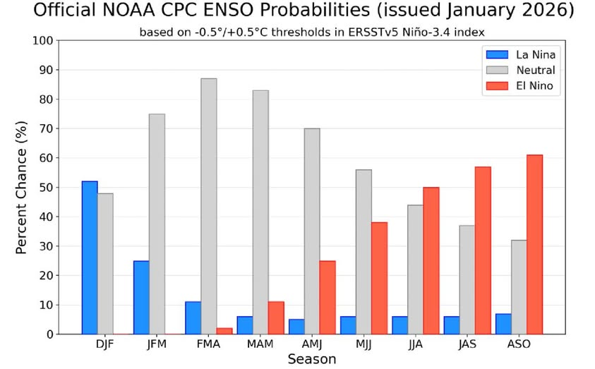
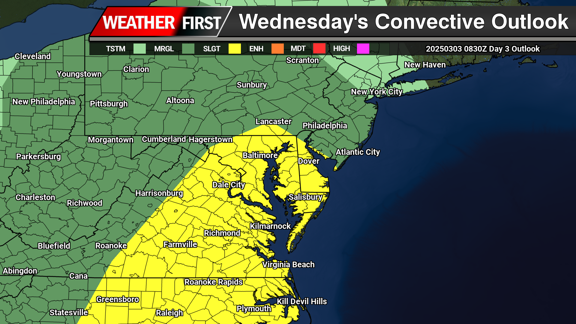
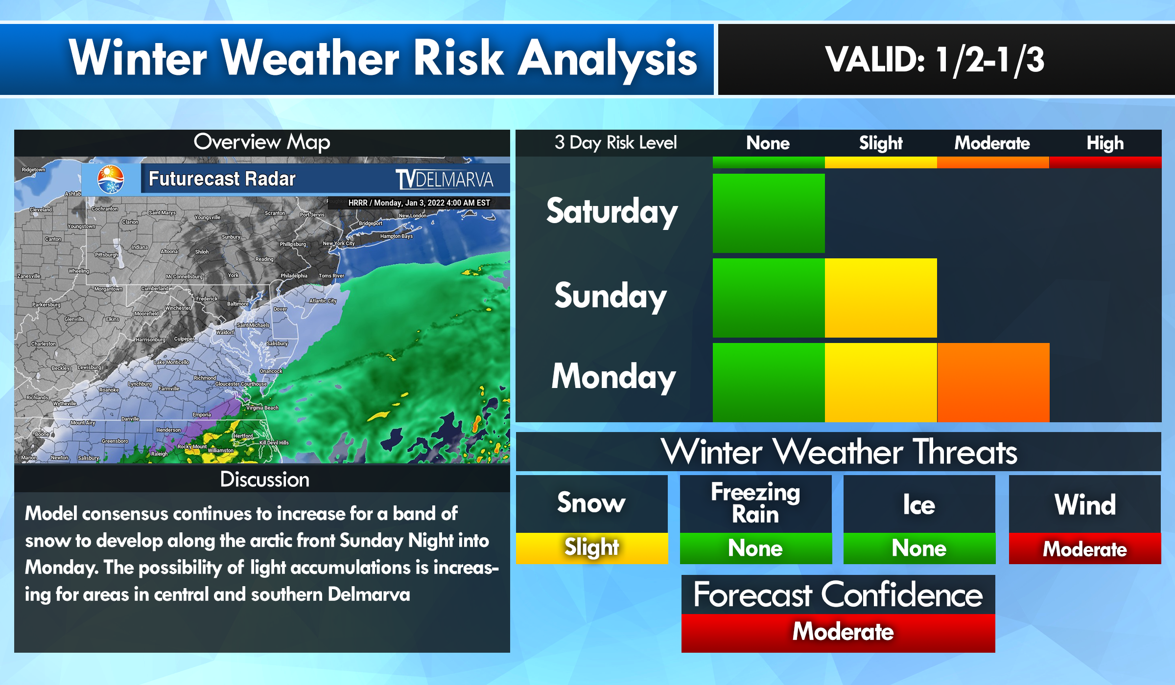
    The latest climate update from the Climate Prediction Center, part of the National Oceanic and Atmospheric Administration, shows that the ongoing La Nina pattern in the Pacific Ocean is weakening. Forecasters say a transition toward more neutral conditions is expected over the next few months.

    La Nina is a climate pattern marked by cooler than normal sea surface temperatures across the central and eastern tropical Pacific Ocean. These cooler waters have persisted into early 2026, based on recent ocean temperature observations. While La Nina remains in place, its influence is beginning to fade.

    According to NOAA, there is about a 75 percent chance that the Pacific will move into ENSO neutral conditions between January and March 2026. ENSO neutral means the Pacific is not in either a La Nina or El Nino phase. Forecast models suggest these neutral conditions could last through at least late spring.

    One of the main signals supporting this shift is warming water beneath the ocean surface. Warmer water that had been confined to the western Pacific is now spreading eastward, helping to weaken the remaining La Nina pattern. While some atmospheric features still resemble La Nina, key wind and temperature signals are gradually trending toward neutral.

    Forecasters caution that even after sea surface temperatures return to neutral, lingering impacts from La Nina could still influence weather patterns during early spring. Looking further ahead, there is increasing potential for El Nino to develop later in 2026, although confidence in that part of the forecast remains lower at this time.

    NOAA continues to monitor ocean and atmospheric conditions closely and will provide regular updates as the Pacific climate pattern evolves. These outlooks help forecasters, emergency planners, and the public prepare for seasonal weather changes influenced by shifts in the tropical Pacific.

  • Drought Conditions Continue to Worsen Across Delmarva

    Drought Conditions Continue to Worsen Across Delmarva

    Dry weather has continued to dominate the Delmarva Peninsula, with the latest drought data showing little improvement and increasing stress across the region. While occasional light rainfall has been observed, precipitation totals remain well below normal, providing minimal benefit to soil moisture, groundwater, or streamflows.

    Across Delaware, Maryland’s Eastern Shore, and Virginia’s Eastern Shore, ongoing precipitation deficits have allowed abnormally dry to drought conditions to persist and expand. Soils continue to dry, particularly in agricultural areas, and streamflows remain below seasonal averages; clear indicators that the region remains in a developing drought pattern.

    In Delaware, short-term dryness is increasingly transitioning into longer-term impacts, with limited recharge of groundwater and growing concerns for water resources if the dry trend continues. On the Maryland Eastern Shore, reduced soil moisture is beginning to affect winter crop establishment and could pose challenges heading into the early spring growing season if meaningful rainfall does not return. Portions of the Virginia Eastern Shore are experiencing similar conditions, with continued low streamflows and dry soils reinforcing drought development.

    Looking ahead, forecasters stress that several widespread, soaking rain events will be necessary to slow or reverse drought conditions across Delmarva. Until a wetter pattern develops, drought impacts are expected to persist through the remainder of the year, with close monitoring in place for further degradation.

  • March 2025 Goes Down as the Windiest on Record for Parts of the U.S.

    March 2025 Goes Down as the Windiest on Record for Parts of the U.S.

    Image From WeatherMatrx

    If you thought March felt windier than usual — you were absolutely right.

    This past March wasn’t just breezy — it was officially the windiest on record for several cities across the Central and Eastern U.S., according to data from the National Weather Service.

    Why Was It So Windy?

    Spring is typically known for being a bit blustery as seasons change. But this year, things were taken to a whole new level.

    Meteorologists say an unusually active jet stream combined with frequent storm systems created a perfect recipe for non-stop wind throughout the month. The strong contrast between areas of high and low pressure kept the air constantly moving — and moving fast.

    Cities That Smashed Records

    Some of the hardest-hit areas for wind records included:

    • Chicago, IL
    • Omaha, NE
    • Kansas City, MO
    • Des Moines, IA

    These cities didn’t just have a few windy days — their average wind speeds for the entire month were 2 to 4 mph higher than normal. That may not sound like much, but for monthly records, that’s a big deal.

    What Were the Impacts?

    The gusty conditions led to plenty of problems:

    • Trees and power lines were knocked down
    • Dust storms reduced visibility across the Plains
    • Wildfire danger spiked in dry areas
    • Air travel was affected with delays and rough landings

    It was a challenging month for truck drivers, travelers, and anyone trying to enjoy the outdoors.

    Will Windy Marches Become More Common?

    It’s too early to say if this is the start of a long-term trend or just a particularly stormy spring. But meteorologists will definitely be keeping an eye on future wind patterns as the climate continues to change.

    Either way, March 2025 will go down in the books as one of the windiest we’ve ever seen — and one that residents across the Midwest and Plains won’t forget anytime soon.

  • Severe Weather And High Winds Possible Again This Weekend On Delmarva

    Severe Weather And High Winds Possible Again This Weekend On Delmarva

    Once again another powerful storm system is expected to develop across the central lower 48 later this week posing a widespread multi-day severe weather outbreak with damaging winds, large hail, tornadoes, and another high wind event impacting millions across the country. The Storm Prediction Center has highlighted a “Slight Risk” of severe weather across the Mid-Atlantic region on Sunday for thunderstorms capable of producing damaging winds along a powerful cold front to swipe through the area.

    Although areas across Delmarva and the surrounding areas will escape the extreme brunt of the severe weather, gusty thunderstorms are possible during the afternoon hours on Saturday where we have surface temperatures well above average into the lower 70s, sufficient moisture with dew points in the 60s, and not to mention the amount of wind shear available. Although the details remain unclear on the severity of the damaging winds or a tornado threat at this time, we will continue to monitor the threat as time gets closer.

    With or without the presence of thunderstorms, strong non-thunderstorm winds will become a problem yet again with wind gusts 40-60 MPH are very possible when this front arrives. Enough to cause more issues with down tree limbs and sporadic power outages. Thunderstorms will only enhance the wind threat more similar to what we seen from last weeks event.

    With a strong low level Jetstream reaching 50-70mph at 5000ft, some of those stronger winds could reach down to the surface at times with the gusty showers and embedded thunderstorms. We will continue to monitor the latest forecast trends as we approach closer towards the weekend.

  • Severe Weather & High Wind Threat Wednesday

    Severe Weather & High Wind Threat Wednesday

    As a powerful storm system begins to develop across the Central Plains, rounds of severe weather are expected from the deep south towards the Mid-Atlantic. As the month turns a new, we are now in Meteorological Spring and the severe weather threats begin showing up across the country.

    As a strong area of low pressure lifts up towards the Great Lakes, a tight pressure gradient will create tons of wind energy all over the eastern portions of the United States. On the warm side of the system as a powerful cold front advances eastward, instability and moisture coming from the Gulf will create a line of strong to severe thunderstorms to move through the Mid-Atlantic Wednesday afternoon.

    A Slight Risk Of Severe Weather is in place across the Delmarva region down towards areas of the Carolinas. Primary threats will include strong damaging winds and the chance of a isolated tornado can not be ruled out. Storm Prediction Center meteorologist Jeremy Kerr had this to say about the overall threat.

       "Models indicate that surface dew points may increase into the 60s F
    in a corridor across the Carolinas through Virginia during the day.
    Latest NAM forecast soundings suggest that this might occur across
    parts of the Carolina Piedmont into coastal plain prior to the
    arrival of a remnant convective band emerging from the eastern Gulf
    States. Although lower/mid-tropospheric lapse rates are forecast to
    be rather weak, weak near-surface destabilization might become
    sufficient to support a risk for tornadoes and/or damaging straight
    line wind gusts, given forecast very large, clockwise curved
    low-level hodographs.

    In the wake of this initial band of convection, beneath a developing
    dry slot, northward moisture advection and insolation to the lee of
    the Blue Ridge may contribute to modest destabilization by late
    Wednesday afternoon. It appears that this will be aided by the
    leading edge of stronger mid-level cooling spreading to the east of
    the Appalachians, and accompanied by increasing thunderstorm
    development in the presence of strong deep-layer shear. Although
    forecast soundings suggest that low-level hodographs may become more
    modest by this time as the stronger low-level jet core spreads
    offshore, the environment may still become conducive to supercells
    with potential to produce severe wind, hail and perhaps a tornado."

    Including the threat for severe weather, high non-thunderstorm wind damage is possible with a strengthening low level jet stream across the region. Model guidance has been showing very strong low level Jetstream winds of 60-80kts at 5000 feet which can be brought down to the surface from heavy rain or thunderstorms.

    As of this time, strong winds of 45 upwards to 60 mph are possible as this powerful cold front arrives during the afternoon hours on Wednesday. Winds of this magnitude can bring down trees and powerlines to create sporadic areas of power outages. Winds will continue to be strong after the cold front passes through as the pressure gradient remaining strong through Thursday.

  • Major Storm System Across The Country Next Week: High Winds & Severe Weather

    Major Storm System Across The Country Next Week: High Winds & Severe Weather

    A major storm system is on the way across the Central Plains towards the East Coast bringing a plethora of heavy rain, severe weather and high winds. A severe weather risk from Tuesday-Wednesday where approximately 60 million people are in the threat regions for damaging winds, large hail, and the threat for tornadoes

    The Storm Prediction Center center highlighting a 30% severe weather risk across Northern Lousiana towards Western Kentucky with a large 15% risk from Illinois towards the Gulf Coast Tuesday. Extending into the Mid-Atlantic and the Southeast US on Wednesday. SPC Meteorologist Jeremy Kerr had this to say about the storm threat next week.

    ” Spread typical at this extended time frame (day 5) lingers among the
    various model output concerning the sub-synoptic, and even synoptic,
    details across the southeastern Great Plains through Ohio Valley and
    Southeast, which may considerably impact the severe weather risk
    area and potential. However, the medium-range guidance depicts an
    environment at least conditionally supportive of an organized severe
    weather event, including potential for a few strong tornadoes and
    damaging straight line winds.

    It is possible, but perhaps a bit more uncertain, that this could
    continue across parts of the southern and middle Atlantic Seaboard
    on Wednesday.”

    While the threat for severe weather isn’t enough, this system will be quite the wind maker as well. A powerful Jetstream combined with a strong low level Jetstream of 60-80kts. Providing a lot of wind energy down towards the surface. And with the presence of thunderstorms, that wind threat may increase even more going forward.

    As of now winds gusting 45-60 MPH are not out of the question come Wednesday which may lead to more episodes of down trees, and sporadic power outages. In the event of thunderstorms are in the mix, winds could become locally stronger bringing some of those powerful winds down to the surface.

  • Snowfall Forecast Across Delmarva Weds-Thurs Feb 19-20th

    Snowfall Forecast Across Delmarva Weds-Thurs Feb 19-20th

    A very difficult forecast remains in place as small portions of Delmarva are under the gun for a significant winter storm. A massive shift in the overall storm track the last 24-48 hours taking what would have been a widespread severe winter storm to more of a nuisance across northern and central Delmarva. And quite honestly one of the biggest failures of all numerical models I have seen thus far in my 15 years of doing this. From having a universal 100% trend for days and days with all the medium range guidance to a 200-300 mile shift south over the weekend is mind boggling.

    NBM blends continue to drop across areas of Central Delmarva where there will be a sharp cut off from the northern axis of precipitation. Light accumulations are expected through these areas while further south in Accomack and Northampton counties are still in great shape of significant accumulations of 6 inches or more.

    Of course there has to be one that wants to throw a wrench into the mix and that is the NAM model which wants to shift back north again bringing the pain of widespread significant snowfall. Although the NAM is on this ship alone which at this point in the game is the major outlier. Especially for the fact of bringing 17 inches snow across Salisbury, MD which was the original outputs before the weekend timeframe with all the guidance. Just not feasible anymore at this late in the game. Unless the NAM is seeing something that we don’t. Which i doubt is the case.

    NOAA’s WSSI Index highlighting moderate to major impacts from this winter storm across Accomack and Northampton counties.

    In the National Weather Service’s Winter Storm Severity Index (WSSI), the “Major Impacts” category indicates potentially life-threatening conditions and significant disruptions to daily life and infrastructure.

    Key Characteristics of “Major Impacts”:

    • Travel may become dangerous or impossible due to heavy snow, ice accumulation, or blizzard conditions.
    • Widespread power outages are likely, especially with ice storms or strong winds.
    • Infrastructure and emergency response may be severely strained, with delayed or limited emergency services.
    • Potential closures of roads, schools, and businesses due to hazardous conditions.
    • Risk to life and property, particularly for those caught in extreme conditions without proper preparation.

    This level is just below the most severe category, “Extreme Impacts,” but still signifies a high-impact winter storm that requires preparation and caution.

  • High Wind Warning Issued For All Of The Mid-Atlantic: What You Need to Know

    High Wind Warning Issued For All Of The Mid-Atlantic: What You Need to Know

    A High Wind Warning is in effect from 10 AM Sunday to 6 PM Monday for all of Delaware, Maryland And Virginia. Strong west winds of 20 to 30 mph with gusts reaching up to 60 mph are expected throughout the region.

    Hazards of High Winds

    Winds of this magnitude can create significant hazards, including:

    • Falling Trees and Power Lines: The combination of strong gusts and saturated ground can easily topple trees, leading to widespread power outages and blocked roadways.
    • Structural Damage: High winds can cause damage to roofs, siding, fences, and outdoor furniture. Unsecured objects can become dangerous projectiles.
    • Difficult Travel Conditions: High-profile vehicles such as trucks, RVs, and buses will be especially vulnerable to strong crosswinds. Bridges and open roads will be hazardous.
    • Flying Debris: Loose objects such as garbage bins, decorations, and construction materials can be lifted and thrown, posing risks to people and property.

    How to Prepare for High Winds

    Taking proactive measures can help reduce damage and improve safety during this event:

    Before the Windstorm

    • Secure Outdoor Objects: Bring in or anchor loose items such as patio furniture, trash cans, and decorations.
    • Trim Trees and Branches: Remove weak limbs that could break and cause damage.
    • Charge Electronics: Power outages are likely, so ensure phones, flashlights, and backup batteries are fully charged.
    • Reinforce Windows and Doors: Close and lock all windows and doors. Consider storm shutters or plywood for additional protection.
    • Prepare an Emergency Kit: Include essentials such as flashlights, extra batteries, bottled water, non-perishable food, first-aid supplies, and necessary medications.

    During the Windstorm

    • Stay Indoors: Remain in the lower levels of your home, away from windows and exterior walls.
    • Avoid Unnecessary Travel: If you must drive, be extra cautious, especially on bridges and open roads.
    • Watch for Falling Debris: Avoid walking under trees, power lines, or unstable structures.

    After the Windstorm

    • Check for Damage: Assess your property for broken windows, roof damage, and fallen trees.
    • Report Power Outages: Contact your local utility provider to report outages or downed power lines. Stay at least 30 feet away from fallen wires.
    • Clear Debris Safely: Use caution when removing branches or other debris from your property.

    Stay Informed

    Monitor updates for real-time alerts and emergency instructions. Keeping informed can help you respond effectively to changing conditions.

    With proper preparation and caution, you can minimize the risks associated with this significant wind event. Stay safe and take necessary precautions to protect yourself, your family, and your property.

  • Washout Of A Weekend On The Way For The Delmarva Region

    Washout Of A Weekend On The Way For The Delmarva Region

    If you were hoping to have a nice weekend ahead with good weather, this is not the weekend for it. Although the rain is welcomed and very beneficial for the ongoing extreme drought we are in, makes for plans to be remaining indoors. Rain will begin to move into the region during the afternoon hours on Saturday as a warm front lifts through. Rain will be heavy at times after dark through the morning hours.

    There will be a lull in the precipitation heading into the later morning hours on Sunday but we will see a noticeable increase in temperatures surging into the mid 60s. A cold front will be arriving later in the after hours bringing back the heavy rainfall and maybe even a few gusty thunderstorms are possible.

    The Storm Prediction center already highlighting a “Marginal” risk of severe weather for the afternoon hours on Sunday as a potential thing line of storms may form along the cold front. Although not expecting widespread thunderstorm development, a few rogue storms are not out of the question.

    Rainfall on the order of 1-2 inches is very plausible before tapering off Sunday night across the region. Might be some low lying area flooding with the recent rainfall events and the major snow melt from a few days ago.

  • Significant Winter Storm Set to Impact the Delmarva Region Tuesday into Wednesday

    Significant Winter Storm Set to Impact the Delmarva Region Tuesday into Wednesday

    Another winter storm is set to impact the region as we move into Tuesday and Wednesday, bringing a mix of heavy snow, ice, and rain across the Delmarva Peninsula. Snow and wintry precipitation will begin Tuesday afternoon and continue through Wednesday morning, leading to widespread travel disruptions and hazardous conditions.

    This storm is developing as a new area of low pressure forms over the Deep South and tracks northeastward along a stalled frontal boundary. At the same time, a strong high-pressure system to the north will funnel cold air into the region, setting the stage for a classic overrunning event. In this setup, warm, moisture-laden air from the Gulf of Mexico moves over the dense, cold Arctic air advancing southward from Canada, creating widespread heavy snowfall from the Midwest into the Mid-Atlantic. This process, known in meteorology as isentropic ascent, drives the formation of clouds and precipitation as the warm air rises and cools.

    In a winter storm overrunning setup, isentropic ascent occurs when warm, moist air is forced to rise over a cold, dense air mass at the surface. This typically happens along a stationary front or warm front, where the warm air follows sloping isentropic surfaces (constant potential temperature). As the air rises, it cools adiabatically, leading to cloud formation and precipitation.

    Since winter storms involve subfreezing surface temperatures, this precipitation can fall as snow, sleet, or freezing rain, depending on the temperature profile. Stronger isentropic ascent enhances moisture transport and lift, leading to heavier and more widespread winter precipitation.

    Snowfall Potential and Accumulation Estimates

    The latest ensemble model guidance indicates a significant increase in snowfall probabilities across central and northern Delmarva. There is now a 60-90% chance of at least 3 inches of snow north of the Maryland-Delaware state line, with 40-60% probabilities for accumulations exceeding 6 inches from Delmar, DE to Smyrna, DE.

    The heaviest snowfall totals are expected between the MD/DE line and Smyrna, where an average of 4 to 8 inches is forecast. This extends westward toward Washington, D.C.. However, localized snow bands could produce isolated totals up to 10 inches, particularly across central Delmarva.

    Coastal and Southern Delmarva Impacts

    Further south, near the coastal areas including Berlin and Pocomoke City, the storm will begin as snow but may transition to a mix of snow, sleet, and rain as temperatures rise above freezing. This will reduce overall snowfall totals due to melting overnight Tuesday into early Wednesday.

    Meanwhile, areas further north will remain all snow, though the intensity may be slightly lower compared to central Delmarva. Regardless, this storm is shaping up to be a significant winter weather event across the region, bringing hazardous travel conditions and potential disruptions.

    Stay tuned for updates as forecast details continue to evolve.

  • Some Beneficial Rain Arriving Tonight: Drought Conditions Continue To Worsen

    Some Beneficial Rain Arriving Tonight: Drought Conditions Continue To Worsen

    A much-needed round of rainfall is set to arrive across the Delmarva Peninsula late tonight, providing a temporary break from the dry conditions that have persisted for months. A warm front will lift through the region after midnight, bringing light to moderate rain that will continue through much of Friday. While occasional breaks in the precipitation are possible, Friday is expected to be a generally wet day before rain tapers off just before sunrise on Saturday morning.

    Rainfall totals will range between 0.5 to 1 inch on average, with localized areas potentially receiving slightly higher amounts. While this rain will help to wash away accumulated road salt and provide some short-term relief, it will do little to alleviate the severe to extreme drought conditions gripping the region. Rainfall deficits remain substantial, with much of Delmarva running nearly a foot below average for the past several months. This system, though beneficial, will barely make a dent in the long-term precipitation shortfall.

    Nonetheless, the rain will bring some temporary improvements to soil moisture levels and reduce the immediate fire danger that has accompanied the prolonged dry spell. However, with no significant additional rainfall in the extended forecast, drought conditions are likely to persist into February.

  • Windy Conditions Moving In For Wednesday: Powerful New England Storm System

    Windy Conditions Moving In For Wednesday: Powerful New England Storm System

    VALID: WEDNESDAY JAN 29TH @ 8AM

    Winds are beginning to intensify along the shoreline as a cold front steadily progresses through the region over the next several hours. Current observations indicate wind gusts already reaching up to 40 mph in some areas, with conditions expected to worsen as the front advances. By tomorrow, winds are forecast to strengthen further as the pressure gradient tightens, resulting in gusts up to 45 mph—nearing Wind Advisory thresholds.

    This increase in wind activity is tied to the influence of a strong low-pressure system currently diving southward from Canada. This system will bring widespread impacts, including areas of heavy snow squalls expected to develop across portions of upstate Pennsylvania and New York on Wednesday. Additionally, the intensification of the low-level jet stream, which is projected to reach speeds between 50 and 80 mph, will contribute to widespread gusty conditions across the mid-Atlantic and Northeast.

    Regions surrounding the Chesapeake Bay and Northern Maryland are expected to experience even stronger winds as the cold front and low-pressure system interact. In particular, wind acceleration along the eastern slopes of the Appalachian Mountains could produce gusts reaching as high as 50 mph. Higher-elevation areas, including parts of Western Maryland and Northern Virginia, where High Wind Warnings are in effect, are likely to encounter gusts exceeding 60 mph at times, presenting potential hazards to outdoor activities, infrastructure, and travel.

    Residents across the affected areas are encouraged to remain vigilant and secure loose objects outdoors, as these strong winds could lead to localized damage and power outages. Travelers should exercise caution, particularly in high-profile vehicles, due to the risk of crosswinds. Stay tuned to local forecasts for updates as this dynamic weather system unfolds.

    Wind Advisory In Effect From 11AM Weds – 6PM Weds

    …WIND ADVISORY IN EFFECT FROM 11 AM TO 6 PM EST WEDNESDAY…

    * WHAT…West winds 20 to 30 mph with gusts up to 50 mph expected.

    * WHERE…Portions of DC, central, north central, northeast, and

    northern Maryland, and northern Virginia.

    * WHEN…From 11 AM to 6 PM EST Wednesday.

    * IMPACTS…Gusty winds will blow around unsecured objects. Tree

    limbs could be blown down and a few power outages may result.

    PRECAUTIONARY/PREPAREDNESS ACTIONS…

    Winds this strong can make driving difficult, especially for high

    profile vehicles. Use extra caution.

  • Rain Chances Increase Later In The Week: Drought Conditions Worsen Here On Delmarva

    Rain Chances Increase Later In The Week: Drought Conditions Worsen Here On Delmarva

    More rain is in the forecast as we approach the weekend, but unfortunately, it is unlikely to significantly alleviate the ongoing drought conditions. Although several snowfall events have occurred this winter—including the major storm on January 5-6—these have not contributed meaningfully to overall precipitation levels. The region remains in a notable deficit, and the upcoming weather system is expected to provide limited relief.

    Later this week, a storm system originating from the Deep South will begin impacting the area. A warm front will approach Friday morning, bringing intermittent light rain throughout the day. This pattern of precipitation will persist into early Sunday morning. Current projections estimate rainfall amounts between 0.50 and 1 inch; however, these figures are subject to change as the system develops. Unfortunately, even this level of precipitation will be insufficient to make a significant dent in the drought conditions.

    Current Precipitation Deficit

    We extend our gratitude to National Weather Service Meteorologist Michael Lee from Mount Holly for providing valuable data and graphical insights into the current precipitation shortfall.

    • Georgetown, DE: From January 28, 2024, to January 27, 2025, the normal precipitation should be 43.98 inches. However, the actual precipitation recorded so far is only 31.66 inches, resulting in a deficit of 12.32 inches.
    • Wilmington, DE: During the same period, normal precipitation is expected to be 45.43 inches, but only 38.37 inches have been recorded, creating a deficit of 7.06 inches.

    These figures highlight the severity of the situation, emphasizing the significant gap that remains to be addressed in the coming months.

    Impacts on Agriculture

    The continued drought is a major concern for local farmers, particularly with the spring growing season fast approaching. Persistent dry conditions are likely to place extreme stress on agricultural operations, potentially affecting crop yields and overall productivity. Addressing this deficit before spring is critical to reducing the strain on farmers who have already faced significant challenges due to drought conditions in recent years.

    While the upcoming rainfall is welcome, it is clear that much more precipitation will be needed to recover from this prolonged dry spell. The hope remains that weather patterns in the next few months will bring sustained rainfall to help close the gap and alleviate some of the burdens facing the region.

  • Warmer Temperatures This Week: Will It Last?

    Warmer Temperatures This Week: Will It Last?

    Many of us have been eagerly anticipating relief from the bitter cold, not only for our comfort but also for some respite from the high costs of heating our homes. Over the last 30 days, we’ve experienced one of the coldest stretches in recent years. In fact, this period ranks as the 6th coldest since 1981, with temperatures averaging a remarkable 9 degrees below normal. However, after enduring weeks of frigid conditions, we’re finally seeing the light at the end of the tunnel as January draws to a close and February begins.

    The dramatic shift in weather patterns can be attributed to a significant change in the overall Northern Hemisphere setup. The persistent lobe of the Polar Vortex, which has been entrenched over the eastern half of the United States, is finally breaking down. This change is ushering in a new phase, with a deep trough developing across the western United States. As a result, Pacific air is beginning to flow more consistently across the lower 48 states. Here in the East, ridging is starting to take hold, allowing for a warmer southerly flow to bring much-needed relief from the cold.

    Now, while we’re not expecting a dramatic swing to extreme warmth akin to the 30-40 degrees below normal temperatures we’ve endured, the return to near-average conditions will be a welcome change. For our region on the Eastern Shore, average temperatures in the mid-40s will feel almost balmy in comparison. In fact, some days may even reach the 50s, which, after this prolonged cold snap, might feel like a veritable heatwave.

    Looking ahead to the next 1-2 weeks, the outlook remains promising. Warmer conditions are expected to persist as February gets underway. Beyond that, the latest 3-4 week outlook from the Climate Prediction Center indicates above-average temperatures for much of the Mid-Atlantic and Southeastern United States. While this signals a reprieve from the deep freeze, the question remains: are we done with the cold and snow for the season? Only time will tell, but for now, we can enjoy a much-deserved break from the relentless chill.

  • Light Snow Event Tonight For Areas Of Southern Delmarva: Dangerous Cold Remains

    Light Snow Event Tonight For Areas Of Southern Delmarva: Dangerous Cold Remains

    A minor to light snowfall event on the way tonight as a rare southern US snowstorm is underway. Areas of Delmarva will see the extreme northern extend of the precipitation shield bringing areas of snow showers tonight, in particular across the VA counties. With extremely cold temperatures in place, this will be a very light and fluffy snow as temperatures are expected to be in the teens by the time the snow arrives later this evening. Most of the snowfall accumulations will be occurring across Northampton and Accomack counties where a short duration 1 to 2 inches are possible. Even though the amount of precipitation is very little of a tenth of a inch or less, temperatures are playing a huge role for “high ratio snowfall”

    The snow-to-liquid ratio is a quantitative measurement of how fluffy or heavy new fallen snow is.  It’s reported as the number of inches of snow that comes from 1 inch of liquid precipitation.  Typical snow-to-liquid ratios vary by region and by the weather pattern producing the snowfall. Air temperature, humidity, and wind speed influence how dense new fallen snow is. The highest snow ratios (or lowest density snow) are usually formed by temperatures that are roughly between 0°F and 10°F, in what is called the “Dendritic Growth Zone.”  This is the regime for forming large dendrites that accumulate with abundant air space between crystals.   New snow grains that are smaller and pack together better form denser snow.  Snow that forms outside of the Dendritic Growth Zone regime will be denser, as will snow that falls through warmer layers or is subject to riming.  Stronger winds will batter snowflakes together as they fall, which breaks down snow crystals into smaller, denser grains.

    ...WINTER WEATHER ADVISORY IN EFFECT FROM 5 PM THIS AFTERNOON TO 7
    AM EST WEDNESDAY...
    
    * WHAT...Snow expected. Total snow accumulations of 1 to 2 inches.
    
    * WHERE...Portions of northeast North Carolina and eastern and
      southeast Virginia.
    
    * WHEN...From 5 PM this afternoon to 7 AM EST Wednesday.
    
    * IMPACTS...Plan on slippery road conditions. The hazardous
      conditions could impact the Tuesday evening and Wednesday morning
      commutes.
    
  • Cold Weather Advisory In Effect: What It Is & How To Prepare

    Cold Weather Advisory In Effect: What It Is & How To Prepare

    A few changes going into this winter season with the replacement of Wind Chill products. Introducing Extreme Cold Weather products with “Cold Weather Advisories” now in place for areas of the Delmarva region starting tonight through Wednesday morning.

    ...COLD WEATHER ADVISORY NOW IN EFFECT FROM 6 PM THIS EVENING TO
    NOON EST WEDNESDAY...
    
    * WHAT...Very cold wind chills as low as 7 below expected.
    
    * WHERE...Delaware, northeast Maryland, central to southern New
      Jersey, and southeast Pennsylvania.
    
    * WHEN...From 6 PM this evening to noon EST Wednesday.
    
    * IMPACTS...The cold wind chills could result in hypothermia if
      precautions are not taken. Frostbite and hypothermia will occur if
      unprotected skin is exposed to these temperatures.
    
    PRECAUTIONARY/PREPAREDNESS ACTIONS...
    
    Use caution while traveling outside. Wear appropriate clothing, a
    hat, and gloves.
    
    Keep pets indoors as much as possible.
    
    Make frequent checks on older family, friends, and neighbors. Ensure
    portable heaters are used correctly. Do not use generators or grills
    inside.

    Extreme Cold Warning vs Watch and Cold Weather Advisory

    • Extreme Cold Warning: Take Action! An Extreme Cold Warning is issued when dangerously cold air temperatures or wind chill values are expected or occurring. If you are in an area with an Extreme Cold Warning, avoid going outside. If you have to go outside, dress in layers, cover exposed skin, and make sure at least one other person knows your whereabouts. Update them when you arrive safely at your destination.
    • Extreme Cold Watch: Be Prepared. An Extreme Cold Watch is issued when dangerously cold air temperatures or wind chill values are possible. As with a Warning, adjust your plans to avoid being outside during the coldest parts of the day. Make sure your car has at least half a tank of gas, and update your winter survival kit.
    • Cold Weather Advisory: Be Aware. A Cold Weather Advisory is issued when seasonably cold air temperatures or wind chill values, but not extremely cold values, are expected or occurring. Be sure you and your loved ones dress appropriately and cover exposed skin when venturing outdoors.

    Dangerous wind chills dropping down below zero are expected for the next few nights here on Delmarva as winds will be gusting 20-30 mph. Temperatures dropping down to the single digits making it the coldest nights we have seen in the last several years.

    Extremely cold air comes every winter into at least part of the country and affects millions of people across the United States. The arctic air can be dangerous. Combined with brisk winds, dangerously cold wind chill values can result. People exposed to extreme cold are susceptible to frostbite and can succumb to hypothermia in a matter of minutes. Areas most prone to frostbite are uncovered skin and the extremities, such as hands and feet. Hypothermia occurs when the body loses heat faster than it can produce it.

    Prepare for Cold Weather

    The way to avoid frostbite and hypothermia is to plan for extreme cold before it arrives. Don’t get caught unprepared.

    • Check the Forecast at weather.gov or your favorite weather app, station, etc.: Make checking the forecast part of your regular routine so you’ll know when to expect cold weather.
    • Adjust Your Schedule: If possible, avoid being outside during the coldest part of the day, typically the early morning. Try to find a warm spot for your children while waiting for the school bus outside.
    • Protect Your Pets, Livestock and other Property: If you have pets or farm animals, make sure they are not overly exposed to extreme cold and have plenty of food and water that has not frozen.Take precautions to ensure your water pipes do not freeze. Know the temperature thresholds of your plants and crops.
    • Fill up the tank: Make sure your car or vehicle has at least a half a tank of gas during extreme cold so that you can stay warm if you become stranded.
    • Dress for the outdoors even if you don’t think you’ll be out much.
    • Update Your Winter Car Survival Kit: Make sure your car survival kit has the following:
      • Jumper cables: flares or reflective triangle are great extras
      • Flashlights: Replace the batteries before the winter season starts and pack extras
      • First Aid Kit: Carry essential medications with you in a purse or bag
      • Baby gear: Diapers and any special formula or food
      • Medical supplies: Materials for any special medical needs.
      • Food: Non-perishable food such as canned food and a can opener, dry cereal and protein rich foods like nuts and energy bars
      • Water: At least 1 gallon of water per person a day for at least 3 days
      • Basic toolkit: Pliers, wrench, screwdriver
      • Pet supplies: Food and water
      • Radio: Battery or hand cranked
      • Cat litter or sand: For better tire traction
      • Shovel: To dig out snow
      • Ice scraper: Have one in the car even if you usually park in a garage
      • Clothes: Dress for the weather in warm clothes, gloves, hat, sturdy boots, jacket and an extra change cold weather of clothes
      • Warmers: For body, hands and feet
      • Blankets or sleeping bags: If you get stranded you’ll be glad to have it.
      • Charged Cell Phone: And keep a spare charger in your car 

    Essential Tasks After it Warms Up

    • Check Your Pipes: Your pipes may be frozen. Water pipes on exterior walls and in places that are subject to cold, like in the basement, attic, and under kitchen cabinets, freeze most often. Water expands as it freezes, causing pipes to burst. If they are frozen, first turn on the faucet. Water will drip as you warm the pipes. Heat the pipes using a space heater, heating pad, electric hair dryer, or hot water on a cloth. Never use an open flame. Continue until water pressure returns to normal or call a plumber if you have more issues.
    • Salt Your Walkways: Once it warms up enough to go out, it’s important to shovel the snow from your sidewalks and driveway or sprinkle salt if there is ice. If there is a thick layer of snow on the ground that you cannot move, salt the area so that the snow melts. You should also put down salt if there is ice on the stairs leading into your house – less than a quarter inch of ice can be dangerous!
    • Call Your Neighbors: Check to see that your neighbors are okay, particularly seniors, disabled persons, or others living alone. Carbon monoxide poisoning is one of the leading causes of death after extreme cold, particularly if there are power outages. Cases of frostbite and hypothermia are also common for elderly people who were stuck in their homes.
    • Refill Your Supplies: This cold event may be over, but there might be another one soon. It is important to always be prepared.
  • Increasing Threat of a Snow Event Sunday Night into Monday For Delmarva

    Increasing Threat of a Snow Event Sunday Night into Monday For Delmarva

    A potential snow event is taking shape for Sunday night into Monday as a dynamic weather pattern evolves. Heading into the weekend, an Arctic boundary is expected to push through the region, bringing temperatures into the upper 40s along with rain. However, a secondary piece of energy trailing behind the front will interact with the boundary, allowing a new low-pressure system to rapidly develop. This setup could result in light to moderate snow accumulations across parts of the area.

    Model Analysis and Comparisons

    ECMWF (European Model):
    Currently one of the most reliable models, the ECMWF suggests a light snow event affecting much of Delmarva and extending into the western shore of Maryland. Projected snowfall totals range between 1 and 4 inches, which aligns with current trends. However, areas along the southern shore may experience a mix of rain and snow due to the proximity of the low-pressure center and the Arctic front.

    UKMET, CMC, and RGEM Models:
    These models present a less favorable scenario for snowfall on the shore, with a more northern storm track that shifts the focus of snow accumulation to Pennsylvania, New Jersey, and extreme northwestern Maryland. The CMC and RGEM in particular show no significant snow accumulations for Delmarva. The UKMET, however, highlights a snow band producing 2 to 4 inches across northern Delmarva, aligning more closely with the ECMWF in terms of low-pressure positioning.

    GFS Model:

    The GFS takes a more expansive approach, forecasting widespread snowfall across the region. Accumulations of 2 to 5 inches are indicated from Easton to Dover and northward toward Wilmington. However, the GFS has shown considerable variability and currently holds the lowest verification rate among the models.

    Key Takeaways

    Confidence is increasing for another accumulating snow event across the region late Sunday into Monday. While there is still some uncertainty regarding the exact track of the low-pressure system and snow totals, current trends suggest a light to moderate event is possible, particularly for snow-prone areas on Delmarva. The National Blend of Models (NBM) also supports the potential for snowfall, giving some hope to snow enthusiasts before the arrival of extreme cold next week.

    Stay tuned for updates as this system develops.

  • Light To Moderate Snowfall Returning To Delmarva This Weekend

    Light To Moderate Snowfall Returning To Delmarva This Weekend

    Here we go ahead folks with another round of snowfall across the shore heading into this weekend. Although not as a major storm like areas of Delmarva witnessed Sunday into Monday, but more of a headache for the already 8-12 inches that remain on the ground currently.

    A southern stream storm system will slide down through the Southeastern US with arctic air already in place blanketed the Deep South with snow & ice before heading off the Carolina coastlines. While this remains a weaker system overall, areas of light to potentially moderate snow is expected across Central and Southern portions of Delmarva. Heaviest impacts will be down in Accomack & Northampton counties in Virginia here on the shore.

    ...WINTER STORM WATCH REMAINS IN EFFECT FROM FRIDAY EVENING THROUGH
    SATURDAY AFTERNOON...

    * WHAT...Heavy mixed precipitation possible. Total snow
    accumulations between 2 and 4 inches and ice accumulations up to
    one tenth of an inch possible.

    * WHERE...Portions of northeast North Carolina and eastern and
    southeast Virginia.

    * WHEN...From Friday evening through early Saturday afternoon.

    * IMPACTS...Plan on slippery road conditions.

    PRECAUTIONARY/PREPAREDNESS ACTIONS...

    Monitor the latest forecasts for updates on this situation.

    Snow will begin to move in across the shore starting in the overnight hours Friday through the morning commute on Saturday. This will be a all snow event for the region as bitter cold arctic air remains locked in across much of the Eastern US.

    As it stands right now, Accomack & Northampton counties will likely see the most snowfall of 2-5″ before tapering off. Across the mid-shore, slightly less amounts of 2-4″ and 1-3″ expected from Pocomoke City towards Georgetown where the snow will be a bit lighter in intensity. Depending how far north the precipitation shield is, these totals could go up or down at this time. Areas across Northern Delmarva will only see about a dusting to a inch maybe if the precip shield is generous enough to keep that far north.

    More updates will follow going into tomorrow with any further changes down the line

  • Another Winter Storm Moves Across The Nation From Texas Towards The Mid-Atlantic

    Another Winter Storm Moves Across The Nation From Texas Towards The Mid-Atlantic

    🌨️ As the Midwest and Mid-Atlantic regions work towards recovery from the significant winter storm that recently impacted the area, we are bracing ourselves for another winter storm on the horizon! This time, the storm is coming from the Deep South, particularly Texas, where people are preparing for several inches of snow and ice starting tomorrow. Even places in the Deep South that usually don’t see snow will experience this major winter weather event!

    🌪️ As the low-pressure system advances into the Southeast, it is expected to spread snow across much of the Midwest, the Carolinas, and into the Mid-Atlantic states. While this storm could have been a significant threat with more interaction from the northern jet stream (potentially leading to an intense East Coast nor’easter this weekend), current models indicate that the storm’s path will remain further south and slightly weaker as it reaches the Eastern USA.

    ❄️ Current analyses suggest light to moderate snowfall accumulations for the Delmarva region, with the heaviest totals anticipated in the southern coastal areas. We’ll continue to monitor the situation closely and provide updates as we receive more detailed forecasts. Stay safe and stay tuned for more information!

  • 🔍 Another Winter Storm is Potentially Approaching This Weekend On Delmarva ❄️

    🔍 Another Winter Storm is Potentially Approaching This Weekend On Delmarva ❄️

    As we continue to recover from the recent winter storm, we want to keep everyone informed about the potential for yet another system approaching this weekend. This upcoming storm is part of the southern stream system that I mentioned prior to Christmas. Originating from the deep south, forecasters are noting an increasing chance for a snowstorm in the DFW area, and winter storm watches are already in effect.

    At this moment, the overall strength of the storm remains uncertain due to an additional weather disturbance that is currently moving down from Canada. The interaction between these two weather systems will be crucial; if they phase together, we could potentially see a stronger storm developing along the eastern seaboard, which might shape into a classic Nor’easter.

    Current forecasts indicate that we may experience a weaker system, with light to moderate snow accumulations expected. However, given the recent snowfall, this could worsen already hazardous travel conditions in the region. We will be keeping a close eye on the development of this weather system and will provide updates as we receive more information. Stay tuned and stay safe!

  • WINTER STORM EXPECTED FOR DELMARVA SUN-TUES / FIRST CALL FORECAST

    WINTER STORM EXPECTED FOR DELMARVA SUN-TUES / FIRST CALL FORECAST

    *** WINTER STORM EXPECTED FOR DELMARVA SUN-TUES / FIRST CALL FORECAST ***

    Alright ladies and gentlemen, for what seems like a eternity, a winter storm storm has it’s eyes on areas of Delmarva later this weekend to the start of the new work week. A mixture of heavy snow, ice, and even rain for portions of the peninsula and surrounding regions. Let’s give the run down on my current thoughts and the nightmare of a forecast this is turning out to be.

    With the current thinking, many areas across Central and Northern Delmarva are in for one of the largest storms we have seen since Jan 29th 2022 with several inches of snowfall in the forecast. One of the most frustrating aspects is dealing with the typical battleground we see here on the shore with the mixing of ice and rain on the southside. Let’s go through the model suite now that the midday runs have come into play.

    Let’s first start off with the GFS model which has been the biggest push north in the overall mixing battle ground up to the Kent/Sussex county line. Significantly dropping totals from areas south of Milford Delaware to a light 1-3 inches. But absolutely crushing areas from Dover on northward with some blends up to a foot. The other American Model the NAM has been slightly cooler solution with mixing up to Georgetown. Widespread areas of 4-8 in with this solution with 0.10-0.20″ of ice. These two models have been the warmest and most north of the spread.

    Now lets get to more southerly solutions which includes the ICON/CMC/UKMET/ECMWF. The UKMET & ECMWF have been extremely consistent keeping the colder air in place for the duration of this storm for many days now. And from a statistically aspect, these have the highest performing verification in this medium and short term range. The overall axis of heaviest snow with these solutions keeps it between Smyrna through Salisbury with on average 4-8 inches with locally higher amounts. Mixing pushed farther south of Salisbury and more snow for areas of the southern shore. ICON/CMC did trend south toward these solutions today as well.

    And one last blend is well the super blended model known as the NBM (National Blend Of Models) which takes in the consideration of many different solutions with a blend together. Here is a loop of the last several solutions where you see the trend north and then the trend back south again. So you see where the difficulty sets in.

    With that said for now I’m doing a blend between the both north and south solutions. I do worry about mixing up to areas of the mid shore for the warmer mid level temperatures with these kinds of storms. And with the lack of a high pressure to the northeast to lock the cold air in makes it very difficult for a all over region snow event. Even being within 54-72hr time from storm moving in we still have these battles to deal with. There will likely be changes with the snowfall forecast going forward until we get into the 24-48 hour range. Keep checking back for updates as this winter storm unfolds.

  • Major Winter Storm Threat Increasing For Sunday – Monday

    Major Winter Storm Threat Increasing For Sunday – Monday

    After taking a look over the the midday model runs and we are still on track for Delmarva seeing a major winter storm for the first time in a few years. But there is some key features I’m keeping a close eye on. Let’s get the run down going…

    I am seeing some trends of the system moving ever so slightly northward which will shift the overall axis of the heaviest snow corridor back towards the MD/DE line on northward with areas further south to be dealing with some ice or even rain the further south you go. This is typical as we get closer in time with the wobbles back and forth which makes winter storm forecasting so much fun… Regardless, everyone will start off with snow in the evening hours on Sunday throughout the night but during the day Monday is when we play hide and seek with the mixing line.

    Right now the big dogs the ECMWF and UKMET which statistically have higher verification rates in this range are showing a sizeable storm to region with widespread >4in from the Salisbury region on northward. Overall not much change with those two models from the last 24 hours which really support heavier snow from the MD/DE line up to Smyrna.

    GFS/ICON/CMC are a little bit more north than the ECMWF/UKMET counterparts with the mixing line going up through almost Milford DE will all snow north of that. Heaviest snow axis with these runs start from Dover up to the Mason Dixon. Trends we have to keep a watch on to see if they continue for that.

    Overall, the threat of a winter storm continues to grow here on Delmarva, just the minor details still need to be ironed out. I’ve highlighted the regions I am thinking currently will be seeing the heaviest snowfall from this storm near the MD/DE line on northward. Not quite ready to do actual snowfall totals as of yet, we will likely have those around this time tomorrow. With support from the NWS in Wakefield showing a good chunk of Delaware and the Maryland Eastern Shore of 50-80% probabilities of snowfall amounts 3 inches or great.

    Keep checking back for updates on this impending winter storm.

  • New Cold Weather Alerts Aim to Simplify Messaging and Highlight Dangers

    New Cold Weather Alerts Aim to Simplify Messaging and Highlight Dangers

    As winter approaches, significant changes are coming to how extreme cold is communicated to the public. Starting this season, the National Weather Service (NWS) will replace wind chill watches, warnings, and advisories with extreme cold watches, warnings, and advisories. This shift aims to enhance understanding of cold weather hazards and ensure that the dangers of low temperatures are effectively conveyed.

    What’s Changing?

    Previously, wind chill alerts were issued only when wind speeds exceeded 10 mph, focusing solely on the combined effect of wind and low temperatures. However, under the new system, alerts will be based on the apparent temperature, which is the lower value of air temperature or wind chill. This adjustment acknowledges that dangerous cold can occur even in calm conditions.

    For example, if the air temperature drops to life-threatening levels but winds remain light, the new extreme cold warning would still be issued—something the prior system didn’t account for.

    Why the Change?

    The updated system reflects a growing understanding of how cold weather impacts people and communities. By removing the 10 mph wind threshold, the change aims to streamline cold weather alerts and emphasize that frigid temperatures can be dangerous with or without wind.

    Wind chill, however, is not disappearing—it will still be forecasted and reported as a key factor in winter weather conditions. The new terminology is designed to simplify messaging for the public while accounting for broader climatological and health impacts.

    New Guidelines for Alerts

    The thresholds for issuing extreme cold watches, warnings, and advisories have been refined to align with historical climate patterns and their potential impacts. These changes also incorporate insights from recent winters, where dangerously low temperatures have posed threats even in the absence of strong winds.

    • Cold Weather Advisory: Issued for conditions that could cause discomfort or mild health impacts for vulnerable populations.
    • Extreme Cold Watch: Used to signal the potential for dangerous cold weather conditions within a few days.
    • Extreme Cold Warning: Issued when life-threatening cold is imminent or occurring.

    A Clearer Message for Safety

    By simplifying the criteria and expanding the scope of dangerous cold conditions, the new system seeks to reduce confusion and encourage timely action during winter weather events. Whether it’s protecting yourself from frostbite and hypothermia or ensuring pets and pipes are safe, these changes emphasize preparedness for all cold weather scenarios.

  • Mid-Atlantic Region Fire and Drought Conditions: November Update

    Mid-Atlantic Region Fire and Drought Conditions: November Update

    As October drew to a close, the Mid-Atlantic region, along with much of the Eastern U.S., grappled with significant fire potential, driven by an exceptionally dry autumn and widespread drought conditions. After a brief lull in September, fire activity surged in early October, prompting the National Preparedness Level to peak at Level 5 on October 8—the third time this year that fire danger hit this critical threshold. Although fire activity moderated later in October, Eastern and Southern areas remained active, especially given below-average precipitation levels that left landscapes parched.

    October’s Unusually Dry Conditions and Elevated Temperatures

    Throughout October, the Mid-Atlantic region endured below-normal rainfall, aligning with dry spells that stretched across the Southeast and Lower Mississippi Valley. Temperatures soared well above average from the West Coast to the Appalachians, with particularly extreme heat anomalies across the Plains and into the East. These conditions resulted in drought expansion, with the U.S. Drought Monitor recording 87% of the country in at least abnormally dry conditions—the highest level on record. Drought impacts were most severe across the Plains, Mississippi Valley, Great Lakes, and Appalachians, but the Mid-Atlantic and New England also experienced a marked increase in drought severity.

    Fire Risks Elevated into November

    Looking ahead, fire potential remains a concern as the dry and warm conditions from October carry into November. The Eastern Mid-Atlantic, in particular, faces continued drought and fire potential due to a combination of dry surface fuels and forecasted below-normal precipitation. While the northern Great Lakes region has recently seen rainfall that reduced fire risk, much of the Mid-Atlantic remains vulnerable. Leaf fall has created additional dry surface fuels, and any windy, dry spells are likely to spur ignition events. The combination of hunting season, outdoor fall activities, and leaf litter increases the likelihood of human-caused fires in these conditions.

    Climate Forecasts: Drought and Temperature Trends

    The Climate Prediction Center’s November outlook projects above-normal temperatures across much of the Eastern U.S., including the Mid-Atlantic. This warmth is expected to persist into the winter, with drier-than-average conditions for the Eastern Area, especially in the Southern Mid-Atlantic. As the weather transitions to a La Niña phase, typical patterns favor continued warm, dry conditions, especially in the southern parts of the region. In the northern areas, periodic rainfall could mitigate fire risks, but with deep soil layers still dry from prolonged summer droughts, potential fires may require extensive effort to control.

    Managing Risks and Potential Outcomes

    As the Mid-Atlantic faces November with elevated fire risks, the region’s significant drought conditions and dry surface fuels make any prolonged dry period dangerous. Fall curing of grasses and shrubs, coupled with leaf litter, provides ample fuel for fire spread in windy conditions. Without sustained rainfall, the fire potential will likely remain above average until either soaking rains or winter snow reduces the risk.

    With forecasters calling for continued warmth and dryness through late fall and early winter, the Mid-Atlantic region must prepare for an active fire season. Proactive measures, public awareness, and careful monitoring will be essential to manage fire risks until conditions improve.

  • Delmarva Faces Worsening Drought: Concerns for Agriculture and Fall Foliage

    Delmarva Faces Worsening Drought: Concerns for Agriculture and Fall Foliage

    The Delmarva Peninsula is currently experiencing one of its driest periods on record, with no measurable rainfall for several weeks. Unfortunately, according to the latest outlook, this dry spell is expected to persist for at least another two weeks, potentially placing Delmarva in the top 10 driest periods on record.

    While many areas across the mid-Atlantic are facing moderate drought conditions, parts of Delmarva are nearing severe drought status. Widespread severe drought conditions are likely to develop within the next one to two weeks, raising serious concerns, particularly for agriculture.

    Impact on Agriculture

    For farmers, the lack of rain couldn’t have come at a worse time. This is the season when many crops require adequate moisture to finish strong before harvest. The drought has already caused stress to crops like corn and soybeans, with yields expected to be lower than usual. Many farmers may struggle to bring in a profitable harvest, and this could lead to higher food prices in the coming months.

    Livestock farmers are also feeling the pressure as the dry conditions limit the growth of pasture grasses, forcing them to use stored feed much earlier than planned. Watering livestock is becoming a challenge in some areas as ponds and wells continue to dry up.

    Fall Foliage at Risk

    Beyond agriculture, the drought is likely to have a noticeable impact on Delmarva’s fall foliage. Trees that are under stress from drought often turn color earlier than usual, but the display may be shorter-lived and less vibrant. Instead of the bright reds, oranges, and yellows typical of fall, leaves may brown and fall off prematurely, leaving the landscape looking bare far earlier than normal.

    A Look Ahead

    The Climate Prediction Center’s 6 to 14-day outlook offers little hope for immediate relief, with dry conditions expected to continue in the near term. However, looking further out, there is a chance that wetter weather may return in the next 6 to 14 weeks, which could help bring much-needed moisture to the region.

    For now, though, the focus is on coping with the ongoing drought and its effects on both agriculture and the environment. Residents are encouraged to conserve water where possible and be prepared for potential crop shortages and higher prices in the months ahead.

  • Major Warm Up Coming Next Week In The Eastern US

    Major Warm Up Coming Next Week In The Eastern US

    As we head into the middle portions of April, we could be looking at some very warm temperatures across the Eastern third of the Nation. A large trough will begin digging into the Western US starting this coming weekend. This will help lift the Jetstream into Canada as a Sub-Tropical Ridge develops off the Southeast US coastlines pumping warm air all the way into New England.

    Temperatures could be running 10-20 degrees above normal during the mid and late portions of next week with this warm southerly flow. High temperatures are expected to be well into the 70’s with some low 80’s not out of the question. The average temperature for this time of year here on Delmarva is around 60 degrees during the daytime hours. I’m sure many will not be complaining about the welcomed warmth ahead.

  • Wind Advisories & Winter Weather Advisories for Saturday

    Wind Advisories & Winter Weather Advisories for Saturday

    ...WIND ADVISORY IN EFFECT FROM 10 AM SATURDAY TO 1 AM EST
    SUNDAY...
    
    * WHAT...Northwest winds 20 to 30 mph with gusts up to 50 mph
      expected.
    
    * WHERE...Portions of New Jersey, southeast Pennsylvania, the
      eastern shores of Maryland and Delaware.
    
    * WHEN...From 10 AM Saturday to 1 AM EST Sunday.
    
    * IMPACTS...Gusty winds could blow around unsecured objects.
      Tree limbs could be blown down and a few power outages may
      result.
    
    * ADDITIONAL DETAILS...Strong winds develop late Saturday morning
      and continue into the afternoon. There may be a lull Saturday
      evening before increasing once again.
    
    ----------------------------------------------------------------
    ...WINTER WEATHER ADVISORY IN EFFECT FROM 6 AM TO 7 PM EST
    SATURDAY...
    
    * WHAT...Snow expected. Total snow accumulations of 1 to 3
      inches. Winds gusting as high as 45 mph.
    
    * WHERE...Portions of northern New Jersey, southeast Pennsylvania
      and northern Delaware.
    
    * WHEN...From 6 AM to 7 PM EST Saturday.
    
    * IMPACTS...Plan on slippery road conditions. Gusty winds could
      bring down tree branches.
  • Growing Concerns For A High Wind Event Thursday Night-Friday

    Growing Concerns For A High Wind Event Thursday Night-Friday

    Growing concerns that we may be dealing with a high wind event evolving during the overnight hours on Thursday into the day on Friday. All thanks to a rapidly developing storm system from the Central Plains that will be driving a cold front through the Eastern Half of the nation. Not to mention the very warm temperatures that will be following the upcoming event as well.

    850mb Winds: Low Level Jetstream

    The main driver for the strong winds we are expecting is the enhancement of the nocturnal low level Jetstream which sits about 5000 feet above the surface. While this area of low pressure continues to strengthen as it crosses into the Great Lakes, the gradient between this area of low pressure and a strong high pressure system off the East Coast will really start enhancing those winds. Forecast models have been quite bold with 70-80kts (80-90 mph) low level jet at 5000 feet which is very strong. Now keep in mind, those winds are pretty high off the ground and unlikely we will see those reaching the surface. With the aid of falling precipitation, we will see some of those stronger winds above he surface to mix down.

    With the strong wind energy with that low level jet, no surprise we can see wind gusts 40-55 mph at the surface during the nighttime hours as the cold front edges closer. Winds of this speed can knock down some tree limbs and cause some sporadic power outages at times. Gusty winds will continue throughout the day on Friday even behind the front.

  • Pending Blizzard On Delmarva; Significant Snowfall On The Way

    Pending Blizzard On Delmarva; Significant Snowfall On The Way

    My poker chips are ALL IN ladies and gentlemen. A major winter storm is coming beginning tonight and going all the way into Saturday Afternoon. Model guidance from last night and this morning has shown a significant shift westward with the track. Coastal Delmarva will be in the hot seat regarding the most significant impacts from this winter storm.

    For the first time since January of 2018, we have Blizzard Warnings for Northampton, Accomack, Worcester, Wicomico, Somerset, and Sussex Counties from 7pm Friday until 7pm on Saturday. Winter Storm Warnings are in place for all of Delmarva except for Cecil County in Maryland. There is very strict criteria in place to qualify for a Blizzard Warning. I do think that a expansion westward with the Blizzard Warnings are not out of the question.

    Futurecast Radar

    Snow will be developing across the region from 5-8pm. And the heaviest will be in place from Midnight tonight through noon Saturday. Significant snowfall rates of 1-3 inches per hour are possible with wind gusts of 40-50 mph. This will create a roadway nightmare on the shore for Saturday morning. Avoid travel at all cost if you can during the height of this blizzard.

  • Snowfall Forecast Thursday Night – Friday Morning *Updated*

    Snowfall Forecast Thursday Night – Friday Morning *Updated*

    Current Snowfall Accumulation Forecast

    We are not finished with the snow just yet. With a decent snow cover still on the ground to this date, more will be added beginning tomorrow night into the morning hours on Friday. This should not be a significant event like we saw on Monday, but enough to cause some roadway problems going into the Friday morning rush hour.

    Risk Analysis Regarding Snow & Travel Over The Next 3 Days

    With light to moderate accumulations on the table, there will be an area of sleet especially near Salisbury, Ocean City, and the Pocomoke City regions where temperatures will be flirting with the 32 degree mark. Locations further north will start out between 32 and 34 degrees before dropping down below freezing, once the precipitation arrives. Another instance of Dynamic Cooling will take place. This will be fairly wet snow just like last time, and it should not have a problem sticking to roadways.

  • Snowfall Forecast For Monday (Updated (9:30pm)

    Snowfall Forecast For Monday (Updated (9:30pm)

    Snowfall Forecast Valid For Monday (Subject To Change)

    Do not let these warm conditions fool you of the arctic snap that’s on our doorsteps today. With a very significant shift in the forecast trending towards the potential biggest storm in the region since 2019. Around this time in 24 hours, we will see a 30-35 degree temperature drop once the arctic front settles in from the north to the region.

    Futurecast Radar

    The main focus mechanism will be a lobe breaking off from the Sub-Tropical Jet Stream that will begin to interact with the stalling out arctic front. The thermodynamic difference along this front will help generate a strong baroclinic forcing. An area of low pressure will begin to intensify later this evening and track just off the coast of the Carolinas. Moisture will then start running into the arctic air mass (overrunning) creating a fairly narrowband of moderate snow to overspread areas from central Virginia into the Delmarva region.

    500mb Vorticity Forecast ECMWF

    For a rare set of parameters, there has been exceptional agreement between ALL model guidance regarding several inches of snow to the region. Some big contenders like the ECMWF (European model) showing some fairly significant snow to the region. GFS being the most robust out of all them showing a foot plus. Although that’s being really extreme and not likely at this time, but we have a great average of 4-8 blend with all the guidance at this time. Subject to chance of course for the difference in small fluctuations on axis and location.

    Winter Storm Warnings / Winter Weather Advisories

    I get a lot of questions and concerns when it comes to the sudden temperature drop and ground temperatures. On the first onset of precipitation, intensity will be key. Just because we were in the 60’s the last few days, falling snow can quickly cool off ground temperatures with the heavier intensity of snowfall. Same with roadways. Snow will be beginning to fall during the pre dawn hours and continue into the afternoon hours.

    Let’s not forget the night after if we have snow cover on the ground. With the arctic air mass settling in and fresh snow cover, temperatures will tank significantly during the overnight hours with clear skies. The snow will act as a blanket keeping the ground temperatures from warming the surface air temperature. Think of it like a cooler with ice in it, the air above the ice is extremely cold but underneath is above freezing. Depending on snow depth covering the ground, temperatures could drop down into the single digits.

    We will continue to provide updates on this potential winter storm going into tomorrow.

  • Record Heat To Accumulating Snow In 36 Hours

    Record Heat To Accumulating Snow In 36 Hours

    Confidence is increasing for snow on Delmarva Monday Morning

    Going to be in for some wacky weather over the next 36-48 hours. First off off we are dealing with very mild temperatures in the 60’s before a arctic front passage pushing through Sunday evening. The arctic front will push through dropping temperatures down below freezing and then stall just south of the Delmarva region. A piece of southern stream energy with the sub-tropical jet will begin to interact with the arctic front having a redevelopment of precipitation and amplification of an area of low pressure to move off the Carolina coasts.

    A good blend of different solutions showing that areas of central and southern Delmarva to pick up a light accumulation of snowfall. Some extreme solutions like the RAP and GFS showing a significant snowstorm to the region with several inches of snowfall but I’m going against that extreme. But i would not doubt some light accumulations are not out of the question.