Tag: travel

  • Icy Post Christmas Storm Across The Northern Mid-Atlantic States

    Icy Post Christmas Storm Across The Northern Mid-Atlantic States

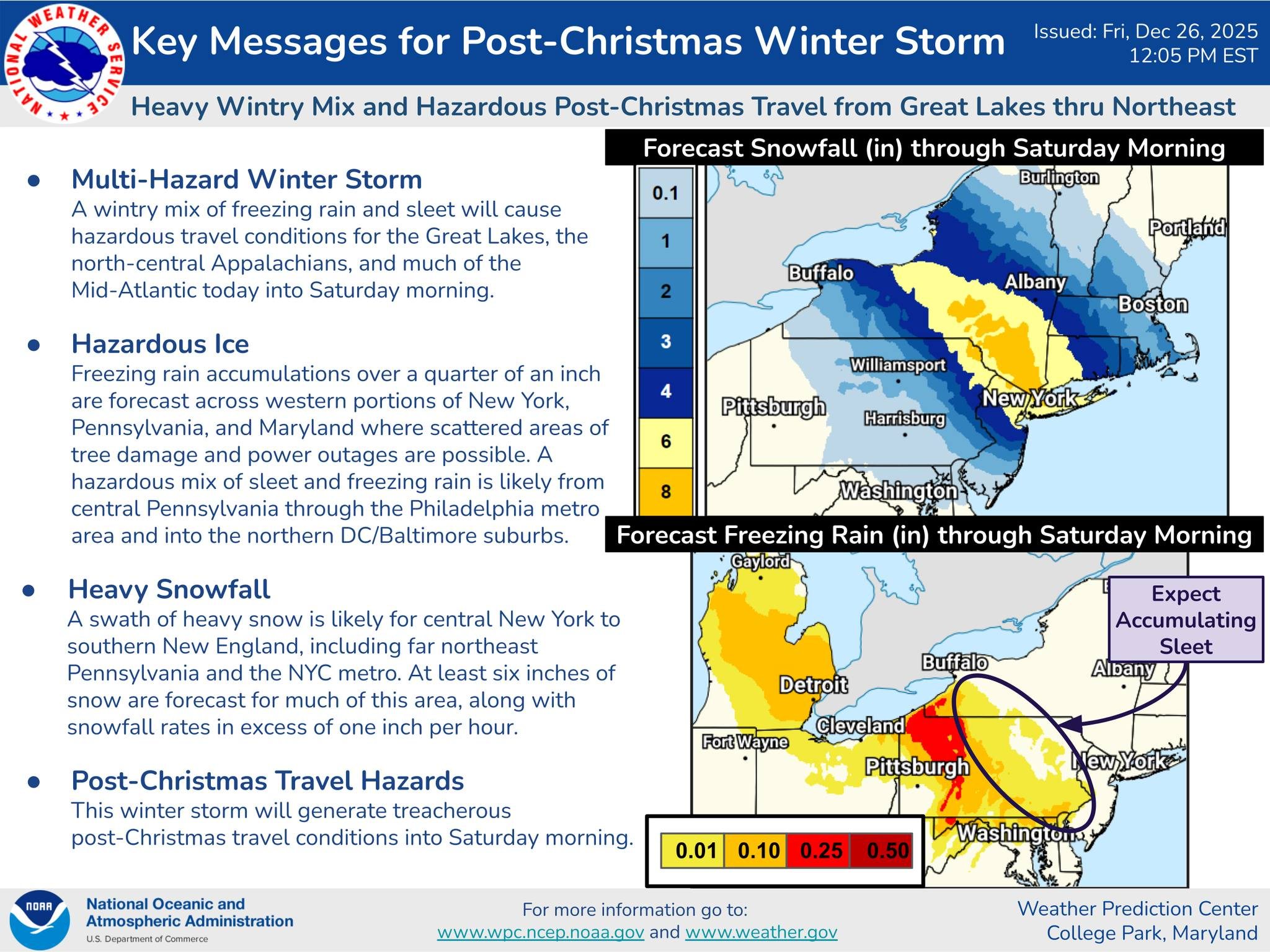
    A significant post-Christmas winter storm is expected to create hazardous conditions from the Great Lakes through the Mid-Atlantic and into the Northeast through Saturday morning, bringing a complex mix of snow, sleet, and freezing rain that will heavily impact travel and infrastructure across the region.

    According to the Weather Prediction Center, this is a multi-hazard winter storm, with the most dangerous impacts tied to ice accumulation and heavy snowfall. A swath of heavy snow is forecast from central New York into southern New England, including portions of northeastern Pennsylvania and the New York City metro area. Many of these locations could see six inches or more of snow, with snowfall rates exceeding one inch per hour at times, leading to rapidly deteriorating road conditions.

    Farther south, the primary concern shifts from snow to ice. Freezing rain and sleet are expected to dominate across portions of Pennsylvania, western and central Maryland, and parts of the Mid-Atlantic, creating a dangerous glaze on untreated surfaces. Ice accumulations over a quarter inch are possible in some areas, increasing the risk for tree damage and scattered power outages.

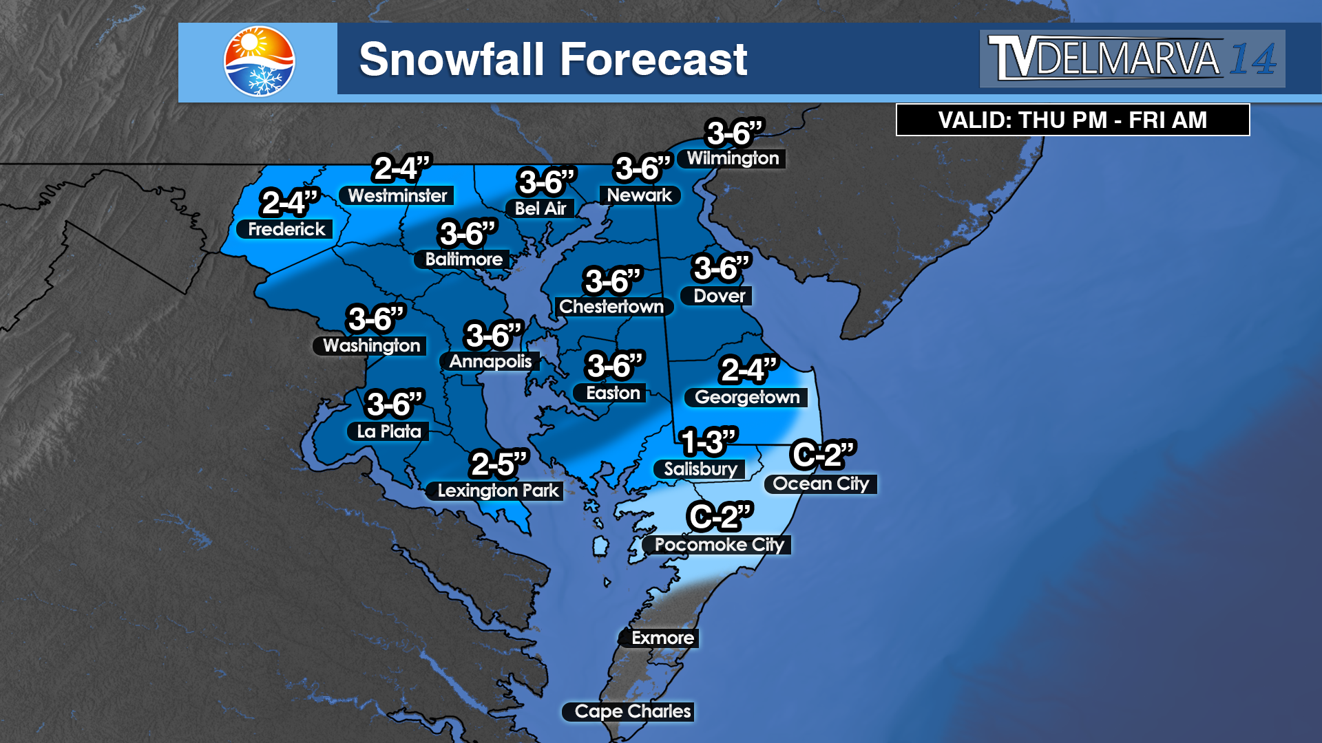
    Northern Maryland Impacts

    Northern Maryland, including areas near and north of the Baltimore metro, is expected to be near the transition zone between snow and freezing rain. This setup raises the risk for significant sleet accumulation followed by freezing rain, which can be particularly hazardous for travel. Roads may quickly become icy, even where surface temperatures hover near freezing. Elevated surfaces such as bridges and overpasses will be especially prone to icing. Any ice buildup on trees and power lines could result in localized outages and downed limbs.

    Northern Delmarva Concerns

    Across northern Delmarva, including Cecil County, Kent County, and areas near the upper Chesapeake Bay, a wintry mix of sleet and freezing rain is expected to develop, particularly late Friday into Friday night. While snowfall totals are likely limited, even light ice accretion could significantly impact travel along major corridors such as I-95, U.S. Route 13, and local secondary roads. Gusty winds combined with ice may further stress trees and utility lines, increasing the risk of isolated power disruptions.

    Travel and Safety Impacts

    The timing of this storm is particularly concerning, as it coincides with post-Christmas travel. Treacherous road conditions are expected to persist into Saturday morning, especially in areas affected by freezing rain and sleet. Visibility reductions, slick surfaces, and rapidly changing precipitation types will make driving dangerous, even for experienced winter drivers.

    Residents across northern Maryland and northern Delmarva are urged to closely monitor forecast updates, avoid unnecessary travel during periods of freezing rain, and prepare for the possibility of power outages. This storm serves as a reminder that ice, even more than snow, can quickly escalate impacts and disrupt daily life across the Mid-Atlantic.

  • Safe travel tips, where to see fireworks this 4th of July

    Safe travel tips, where to see fireworks this 4th of July

    If you’re planning to travel for the 4th of July holiday, expect company.

    .

    Already the roads across Delaware and Delmarva are jammed packed with visitors, so extra caution when out and about this holiday weekend. Triple-A Mid-Atlantic reports that nearly 50 million people will be traveling this weekend, a new record despite gas prices sitting at an average of $4.84 nationwide, with average prices at $4.75 here in Delaware.

    .

    Some tips for traveling this 4th of July includes:

    Have a plan A, B and C. Flights, car rentals, accommodations, tours, cruises and other activities are in high demand and availability may be limited, which will impact pricing. Finding last-minute deals is unlikely so it’s recommended to look for discounts and rewards, usually available through a membership like AAA. This is also another time when travel advisors are a great resource since they may know of a deal that may not be readily available to the public.

    .
    Air—AAA finds that the average lowest airfare is 14% more than last year coming in at $201/ticket.
    Hotels—Mid-range hotel rates have increased about 23%, with the average lowest nightly rates coming in at $244/night for AAA Approved Hotels.

    .
    Car Rentals— Since late last year, the average daily rate for car rentals has continued to increase. With more people traveling, these prices remain on the rise due to continued supply chain issues coupled with growing demand. However, because we saw record high rental car rates last year for the Independence Day holiday due to limited inventory, daily car rental rates have actually decreased 34% compared to last years holiday, with the average lowest rate coming in at $110/day on average compared to 2019.

    .
    B-E-T on a breakdown-free trip. AAA expects to respond to over 446,000 calls for roadside assistance over the Independence Day holiday weekend. Make sure to get a full vehicle inspection ahead of any long trip but especially for components like a vehicle’s battery, engine and tires. Even a vehicle in top shape can run into an issue so it’s a good idea to pack a well-stocked emergency kit and have roadside assistance just in case.

    .
    Beat the rush. Travel on off-peak times or days or pick a hidden gem closer to home. Based on AAA booking data, Friday, July 1 is shaping up to be the busiest day for air travel during the holiday weekend (June 30 – July 4) with Monday, July 4 being the lightest. For those hitting the road, the Thursday and Friday before the holiday are anticipated to be peak traffic days.


    where you can see fireworks set off on this 4th of July:

    Bethany Beach: Monday, July 4
    Dover: Monday, July 4, at 9:15 p.m
    Laurel: Monday, July 4
    Lewes: Monday, July 4 (famous boat parade at 1:30 p.m.)
    Rehoboth Beach: Sunday, July 3
    Smyrna/Clayton: Monday, July 4

  • Snowfall Forecast Thursday Night – Friday Morning *Updated*

    Snowfall Forecast Thursday Night – Friday Morning *Updated*

    Current Snowfall Accumulation Forecast

    We are not finished with the snow just yet. With a decent snow cover still on the ground to this date, more will be added beginning tomorrow night into the morning hours on Friday. This should not be a significant event like we saw on Monday, but enough to cause some roadway problems going into the Friday morning rush hour.

    Risk Analysis Regarding Snow & Travel Over The Next 3 Days

    With light to moderate accumulations on the table, there will be an area of sleet especially near Salisbury, Ocean City, and the Pocomoke City regions where temperatures will be flirting with the 32 degree mark. Locations further north will start out between 32 and 34 degrees before dropping down below freezing, once the precipitation arrives. Another instance of Dynamic Cooling will take place. This will be fairly wet snow just like last time, and it should not have a problem sticking to roadways.