Tag: tornadoes

  • Severe Weather On Tap For Monday Evening Across Delmarva

    Severe Weather On Tap For Monday Evening Across Delmarva

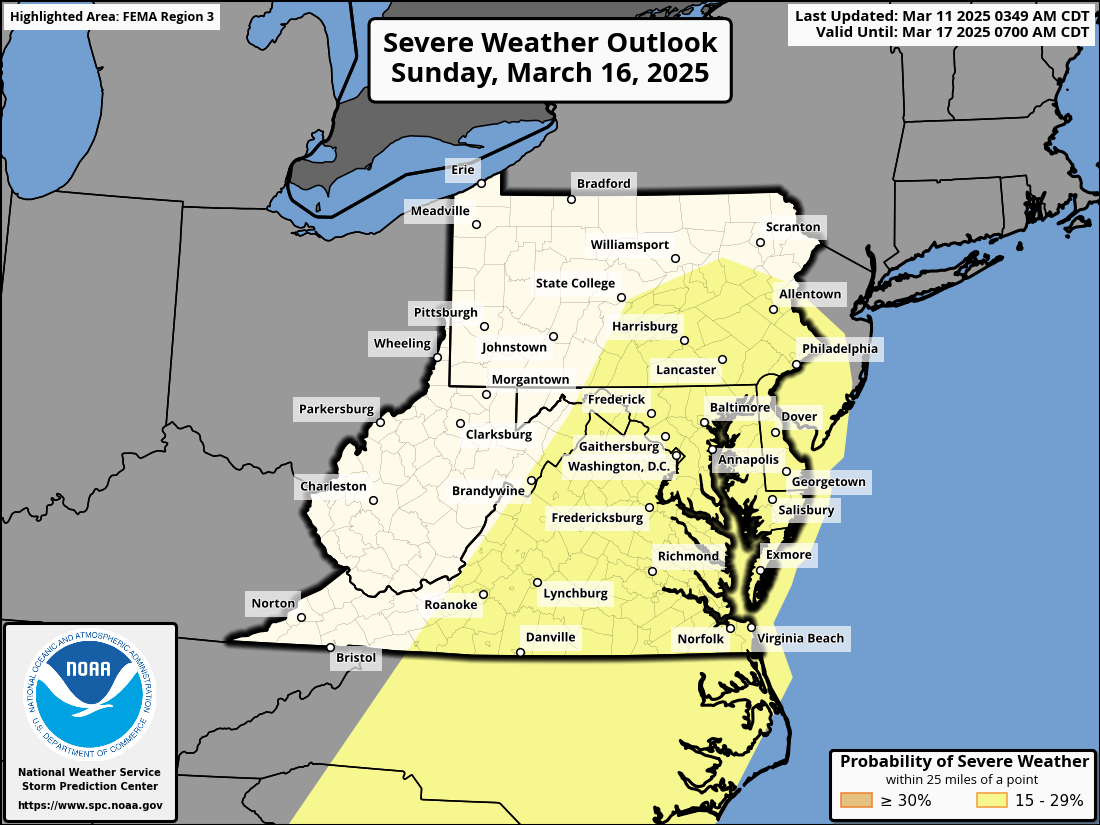
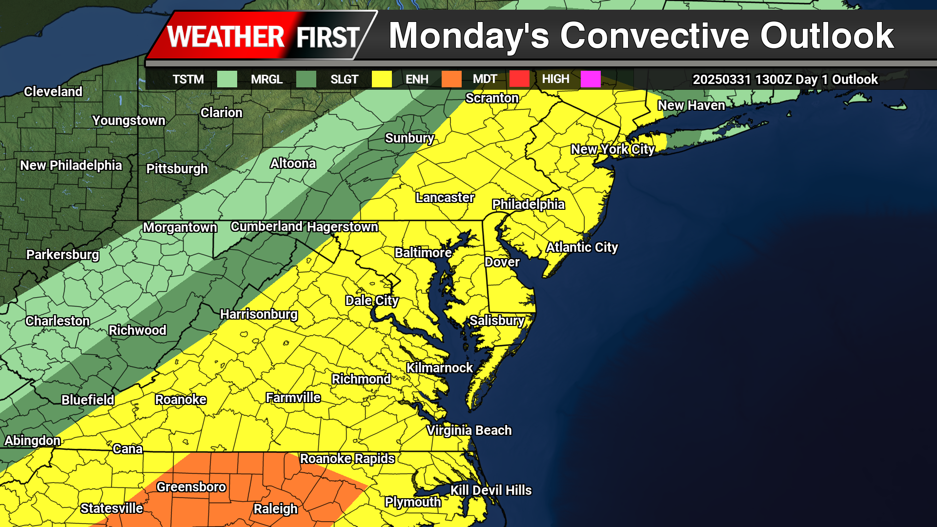
    Strong to severe thunderstorms remain on tap as we venture into the afternoon and evening hours today as a strong cold front advances from the west. A “Slight Risk” of severe weather from the Storm Prediction Center laid across all of the Mid-Atlantic today.

    Looking at satellite this morning over towards our west a nice blanket of sunshine moving into the region to help destabilize the atmosphere with surface heating as temperatures are expected to be well into the 70s as dew points surge into the 60s to have plenty of moisture in place. Well suited for thunderstorm develop later today.

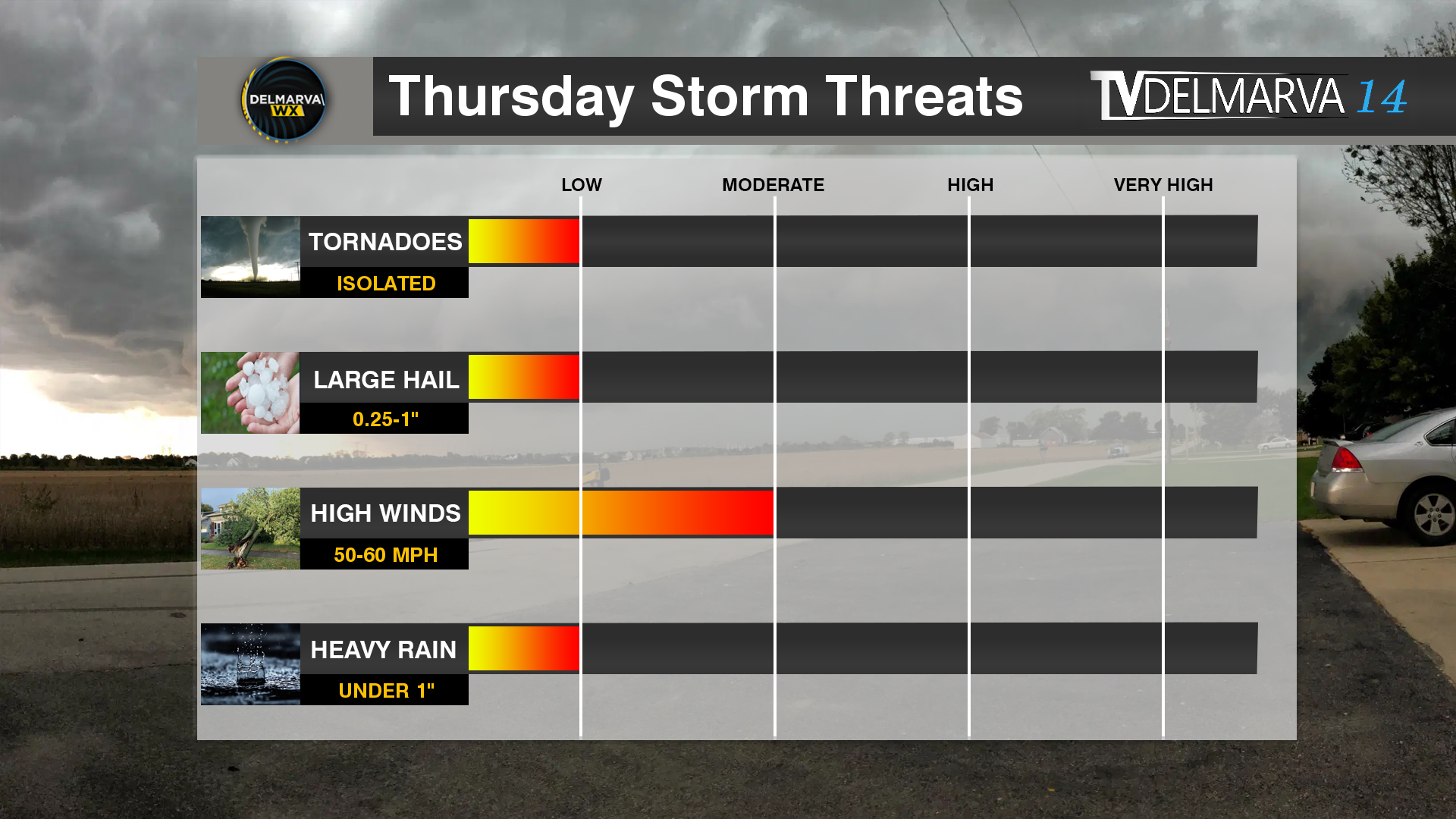
    The first round of storms will begin to develop across the Maryland Western shore around the mid-afternoon hours (4-5PM) which will have the highest chances of larger hail or even an isolated tornado being discrete in nature. Later in the evening hours as the cold front arrives, a squall line likely to develop with the primary threat of damaging straight line winds. Although a quick spin up in the line is always a possibility but those probabilities remain on the low side of things.

    As mentioned before, the primary threat for the storms this afternoon will be indeed damaging straight line winds from the main squall line that moves through towards the evening hours from 7-10PM. Winds gusting as high as 70 mph are possible with the strongest portions of the line. Heavy rainfall from the squall line of 1-3″/hr could lead to some localized flooding in spots. During the mid afternoon hours when a few discrete cells form will have the best shot of large hail to 1″ or locally larger. Tornado threat remains low but not impossible for the first cells to develop in the afternoon hours and then again in the line itself.

  • Severe Weather And High Winds Possible Again This Weekend On Delmarva

    Severe Weather And High Winds Possible Again This Weekend On Delmarva

    Once again another powerful storm system is expected to develop across the central lower 48 later this week posing a widespread multi-day severe weather outbreak with damaging winds, large hail, tornadoes, and another high wind event impacting millions across the country. The Storm Prediction Center has highlighted a “Slight Risk” of severe weather across the Mid-Atlantic region on Sunday for thunderstorms capable of producing damaging winds along a powerful cold front to swipe through the area.

    Although areas across Delmarva and the surrounding areas will escape the extreme brunt of the severe weather, gusty thunderstorms are possible during the afternoon hours on Saturday where we have surface temperatures well above average into the lower 70s, sufficient moisture with dew points in the 60s, and not to mention the amount of wind shear available. Although the details remain unclear on the severity of the damaging winds or a tornado threat at this time, we will continue to monitor the threat as time gets closer.

    With or without the presence of thunderstorms, strong non-thunderstorm winds will become a problem yet again with wind gusts 40-60 MPH are very possible when this front arrives. Enough to cause more issues with down tree limbs and sporadic power outages. Thunderstorms will only enhance the wind threat more similar to what we seen from last weeks event.

    With a strong low level Jetstream reaching 50-70mph at 5000ft, some of those stronger winds could reach down to the surface at times with the gusty showers and embedded thunderstorms. We will continue to monitor the latest forecast trends as we approach closer towards the weekend.

  • Severe Weather & High Wind Threat Wednesday

    Severe Weather & High Wind Threat Wednesday

    As a powerful storm system begins to develop across the Central Plains, rounds of severe weather are expected from the deep south towards the Mid-Atlantic. As the month turns a new, we are now in Meteorological Spring and the severe weather threats begin showing up across the country.

    As a strong area of low pressure lifts up towards the Great Lakes, a tight pressure gradient will create tons of wind energy all over the eastern portions of the United States. On the warm side of the system as a powerful cold front advances eastward, instability and moisture coming from the Gulf will create a line of strong to severe thunderstorms to move through the Mid-Atlantic Wednesday afternoon.

    A Slight Risk Of Severe Weather is in place across the Delmarva region down towards areas of the Carolinas. Primary threats will include strong damaging winds and the chance of a isolated tornado can not be ruled out. Storm Prediction Center meteorologist Jeremy Kerr had this to say about the overall threat.

       "Models indicate that surface dew points may increase into the 60s F
    in a corridor across the Carolinas through Virginia during the day.
    Latest NAM forecast soundings suggest that this might occur across
    parts of the Carolina Piedmont into coastal plain prior to the
    arrival of a remnant convective band emerging from the eastern Gulf
    States. Although lower/mid-tropospheric lapse rates are forecast to
    be rather weak, weak near-surface destabilization might become
    sufficient to support a risk for tornadoes and/or damaging straight
    line wind gusts, given forecast very large, clockwise curved
    low-level hodographs.

    In the wake of this initial band of convection, beneath a developing
    dry slot, northward moisture advection and insolation to the lee of
    the Blue Ridge may contribute to modest destabilization by late
    Wednesday afternoon. It appears that this will be aided by the
    leading edge of stronger mid-level cooling spreading to the east of
    the Appalachians, and accompanied by increasing thunderstorm
    development in the presence of strong deep-layer shear. Although
    forecast soundings suggest that low-level hodographs may become more
    modest by this time as the stronger low-level jet core spreads
    offshore, the environment may still become conducive to supercells
    with potential to produce severe wind, hail and perhaps a tornado."

    Including the threat for severe weather, high non-thunderstorm wind damage is possible with a strengthening low level jet stream across the region. Model guidance has been showing very strong low level Jetstream winds of 60-80kts at 5000 feet which can be brought down to the surface from heavy rain or thunderstorms.

    As of this time, strong winds of 45 upwards to 60 mph are possible as this powerful cold front arrives during the afternoon hours on Wednesday. Winds of this magnitude can bring down trees and powerlines to create sporadic areas of power outages. Winds will continue to be strong after the cold front passes through as the pressure gradient remaining strong through Thursday.

  • Major Storm System Across The Country Next Week: High Winds & Severe Weather

    Major Storm System Across The Country Next Week: High Winds & Severe Weather

    A major storm system is on the way across the Central Plains towards the East Coast bringing a plethora of heavy rain, severe weather and high winds. A severe weather risk from Tuesday-Wednesday where approximately 60 million people are in the threat regions for damaging winds, large hail, and the threat for tornadoes

    The Storm Prediction Center center highlighting a 30% severe weather risk across Northern Lousiana towards Western Kentucky with a large 15% risk from Illinois towards the Gulf Coast Tuesday. Extending into the Mid-Atlantic and the Southeast US on Wednesday. SPC Meteorologist Jeremy Kerr had this to say about the storm threat next week.

    ” Spread typical at this extended time frame (day 5) lingers among the
    various model output concerning the sub-synoptic, and even synoptic,
    details across the southeastern Great Plains through Ohio Valley and
    Southeast, which may considerably impact the severe weather risk
    area and potential. However, the medium-range guidance depicts an
    environment at least conditionally supportive of an organized severe
    weather event, including potential for a few strong tornadoes and
    damaging straight line winds.

    It is possible, but perhaps a bit more uncertain, that this could
    continue across parts of the southern and middle Atlantic Seaboard
    on Wednesday.”

    While the threat for severe weather isn’t enough, this system will be quite the wind maker as well. A powerful Jetstream combined with a strong low level Jetstream of 60-80kts. Providing a lot of wind energy down towards the surface. And with the presence of thunderstorms, that wind threat may increase even more going forward.

    As of now winds gusting 45-60 MPH are not out of the question come Wednesday which may lead to more episodes of down trees, and sporadic power outages. In the event of thunderstorms are in the mix, winds could become locally stronger bringing some of those powerful winds down to the surface.

  • Tropical Troubles Into The Weekend

    Tropical Troubles Into The Weekend

    A big tone shift with the overnight model runs shows full speed ahead of a tropical system moving in from the Carolinas up into the Chesapeake Bay region. Which is the worst case scenario for any track of a storm system here on the shore.

    Many of the high resolution model guidance showing heavy rain beginning to move in starting in the evening hours on Friday from south to north as the winds start to increase from the east. Winds could be gusting as high as 50 mph along the coastlines with 40-50 for the inland locations. Along with the major waves coming ashore of 10-20 feet. Combination of a high tide cycle, heavy rainfall, strong long fetched onshore winds, coastal flooding is going to be a big problem.

    Early indications from a few days ago had flooding in the minor to borderline moderate levels. Well with high confidence now with the storm track and overall strength, moderate to potential major levels of coastal flooding exist for all water ways along the Atlantic, Delaware Bay, and of course the inland bays in Sussex, Kent and Worcester counties. Inundation of 1-3 feet are on the table on Saturday.

    Rainfall with tropical moisture is surely going to be a issue for areas along coastal Delaware down the Bay Bridge Tunnel. across the mid-shore we will average of 2 to 5 inches of rain. Highest for those farthest south and east.

    Now my least favorite topic, tornadoes. If we do have a tropical system on our hands rather than a hybrid or extra tropical cyclone, being on the right side of it is never a good thing. Slight curvature in the hodographs suggest we do have some turning in the atmosphere. Whether we have the little bit of instability remains to be in question. Tornadoes are a possibility but not with very high confidence right now.

    Prepare for a potentially major storm system heading into this weekend.

  • Severe Weather Threat For Thursday

    Severe Weather Threat For Thursday

    While we are now in the short term model guidance, we had a big shift in the timing of this event. On Tuesday many of the medium range model guidance showed this event to be extremely underwhelming and much later into the night. Now into Wednesday, we have pushed the timing up about 6-8 hours into the afternoon and evening hours on Thursday. That big shift in timing boosted our chances to match with the SPC’s Slight Risk of Severe Weather they had all week.

    A good agreement between the HRRR/RAP as well as the CAMS showing ample thunderstorm development across the Mid-Atlantic States. An increase in instability as well with dew points going into the lower 60’s. Storms should be developing from west to east from 2-10pm.

    With the main threat being wind damage within these storms. No surprise with the strong winds aloft and in the lower level Jetstream. Strong winds at 5000 feet of 60-70 kts giving ample speed shear for storms to produce some gusty downbursts. Using TEHI for the tornadic threat and the good news is once more, fairly low probabilities. TEHI values under 2 (20%) chance of these storms producing a tornado in this environment. Also when we take a look at the Updraft Helicity Streaks, there is very little if any which is good news for shows storms with potential rotation on the models.