Tag: tornado

  • NWS Confirms EF-0 Tornado In Omar, DE On Monday

    NWS Confirms EF-0 Tornado In Omar, DE On Monday

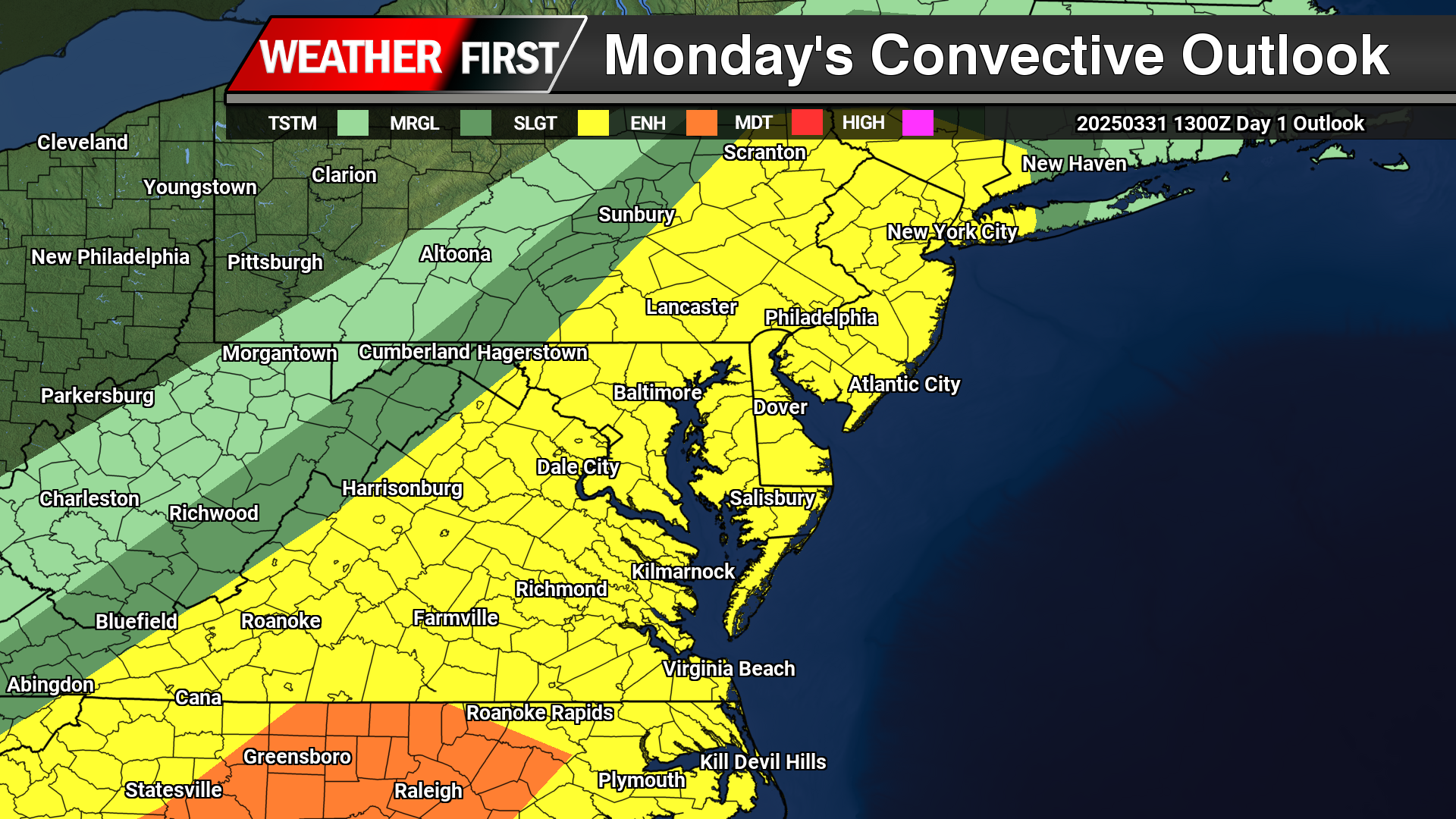
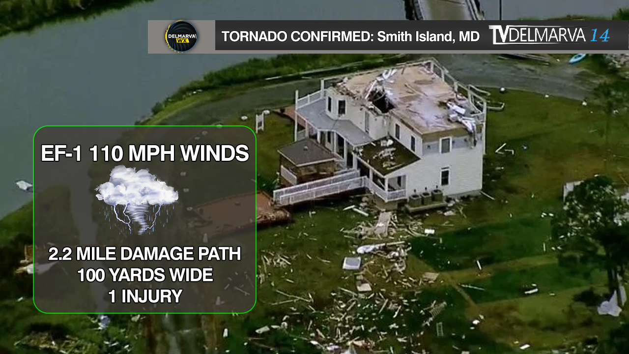
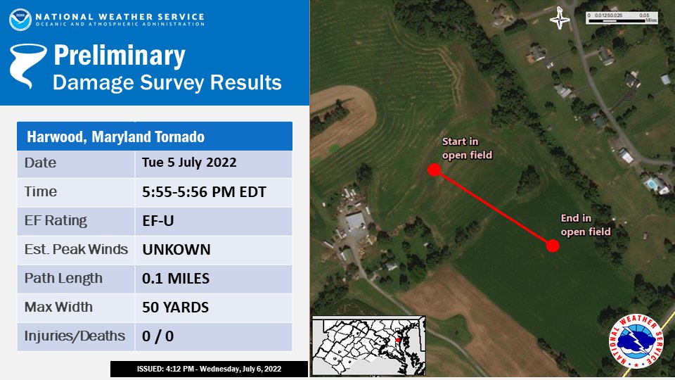
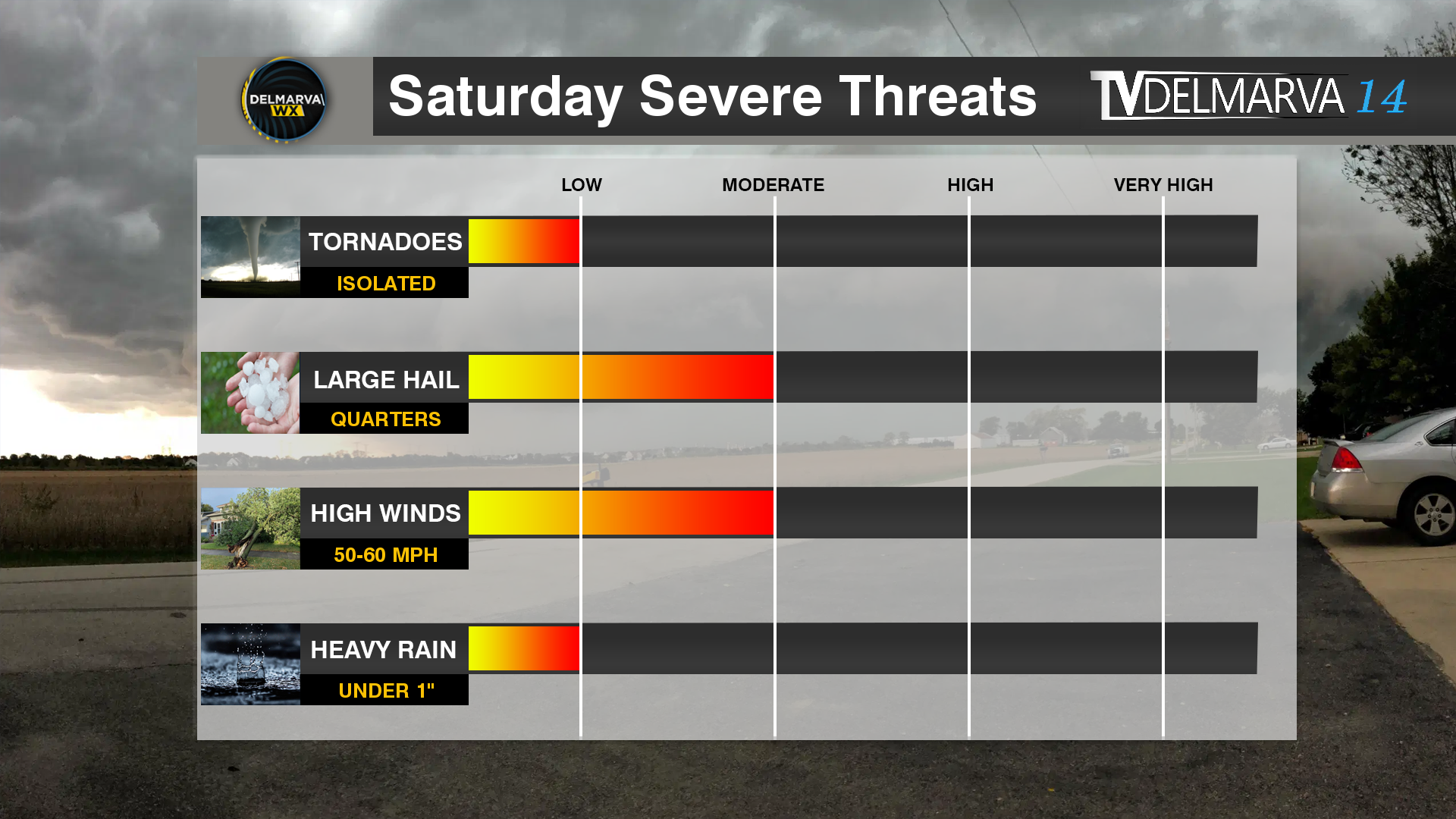
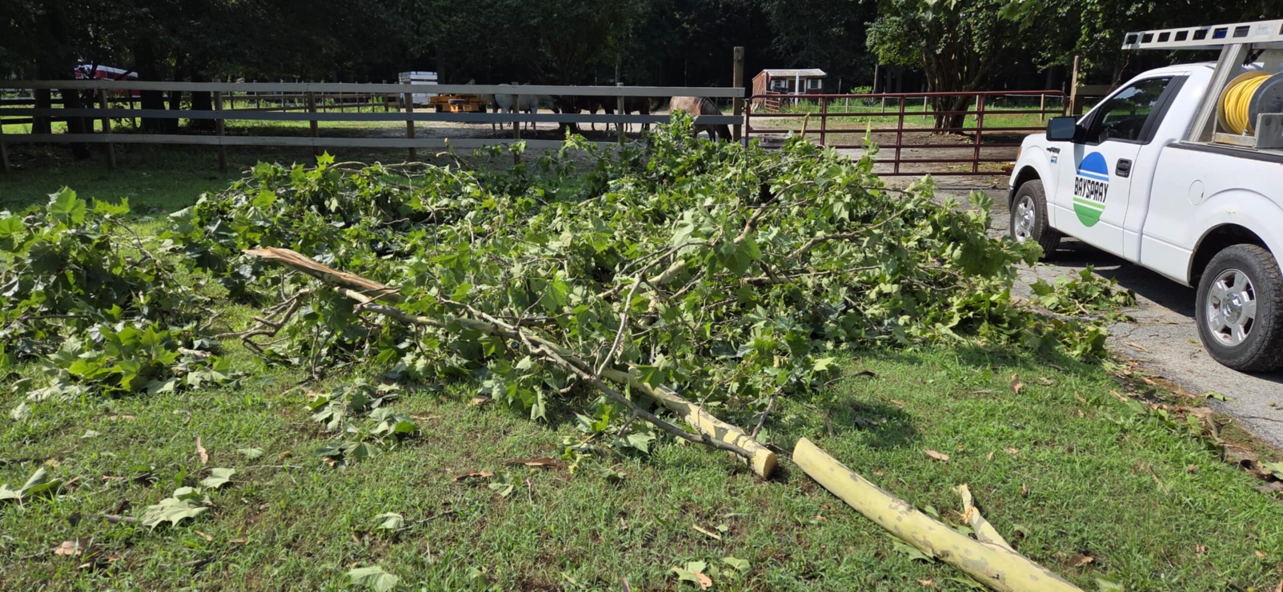
    Public Information Statement
    National Weather Service Mount Holly NJ
    1224 PM EDT Wed Jul 2 2025
    
    ...NWS Damage Survey for Sussex County DE Tornado Update #1...
    
    .Update...EF-0 Tornado Confirmed in Frankford, DE on June 30th
    
    .Frankford Tornado...
    
    Rating:                 EF-0
    Estimated Peak Wind:    65 mph
    Path Length /statute/:  0.5 miles
    Path Width /maximum/:   100 yards
    Fatalities:             0
    Injuries:               0
    
    Start Date:             June 30, 2025
    Start Time:             1:16 PM EDT
    Start Location:         Frankford, DE
    Start Lat/Lon:          38.5266, -75.2111
    
    End Date:               June 30, 2025
    End Time:               1:16 PM EDT
    End Location:           Frankford, DE
    End Lat/Lon:            38.5243, -75.2016
    
    Damage assessment determined that an EF0 tornado with a maximum
    wind speed of 65 mph briefly touched down along Omar Rd in
    Frankford, DE and moved ESE over a heavily forested area towards
    Shockley Town Rd. Several brief video clips shared by broadcast
    media and social media showed various angles of a tornado in
    progress in the heavily forested area between Omar Rd and
    Shockley Town Rd. Several large branches were twisted and snapped
    along Omar Rd. Additional damage is possible in the heavily
    forested area, but the survey team was unable to access the area.
    
    Special thanks to local media and the Sussex County Emergency
    Management for their assistance in this storm survey.
    
    &&
    
    EF Scale: The Enhanced Fujita Scale classifies tornadoes into the
    following categories:
    
    EF0.....65 to 85 mph
    EF1.....86 to 110 mph
    EF2.....111 to 135 mph
    EF3.....136 to 165 mph
    EF4.....166 to 200 mph
    EF5.....>200 mph
    
    NOTE:
    The information in this statement is preliminary and subject to
    change pending final review of the event and publication in NWS
    Storm Data.
  • Severe Weather On Tap For Monday Evening Across Delmarva

    Severe Weather On Tap For Monday Evening Across Delmarva

    Strong to severe thunderstorms remain on tap as we venture into the afternoon and evening hours today as a strong cold front advances from the west. A “Slight Risk” of severe weather from the Storm Prediction Center laid across all of the Mid-Atlantic today.

    Looking at satellite this morning over towards our west a nice blanket of sunshine moving into the region to help destabilize the atmosphere with surface heating as temperatures are expected to be well into the 70s as dew points surge into the 60s to have plenty of moisture in place. Well suited for thunderstorm develop later today.

    The first round of storms will begin to develop across the Maryland Western shore around the mid-afternoon hours (4-5PM) which will have the highest chances of larger hail or even an isolated tornado being discrete in nature. Later in the evening hours as the cold front arrives, a squall line likely to develop with the primary threat of damaging straight line winds. Although a quick spin up in the line is always a possibility but those probabilities remain on the low side of things.

    As mentioned before, the primary threat for the storms this afternoon will be indeed damaging straight line winds from the main squall line that moves through towards the evening hours from 7-10PM. Winds gusting as high as 70 mph are possible with the strongest portions of the line. Heavy rainfall from the squall line of 1-3″/hr could lead to some localized flooding in spots. During the mid afternoon hours when a few discrete cells form will have the best shot of large hail to 1″ or locally larger. Tornado threat remains low but not impossible for the first cells to develop in the afternoon hours and then again in the line itself.

  • Delaware Severe Weather Awareness Week: Day 2 “Tornado Safety”

    Delaware Severe Weather Awareness Week: Day 2 “Tornado Safety”

    Delaware Severe Weather Awareness Week is a reminder that Delaware has been hit with many major weather events within the past five years. This year marks five years since Tropical Storm Isaias spawned the longest tornado ever recorded in Delaware, which wreaked a path of destruction as it traveled from Dover in Kent County to Glasgow in New Castle County. In April of 2023, a tragic tornado fatality occurred in Sussex County. It was the first tornado-related death since two people were killed near a mobile home community near Hartly on July 21, 1983. Record rainfall from the remnants of Hurricane Ida in 2021 caused historic flooding in parts of downtown Wilmington,

    What is a Tornado?

    A tornado is a violently rotating column of air extending from the base of a thunderstorm down to the ground. Tornadoes are capable of completely destroying well-made structures, uprooting trees, and hurling objects through the air like deadly missiles. Tornadoes can occur at any time of day or night and at any time of the year. Although tornadoes are most common in the Central Plains and the southeastern United States, they have been reported in all 50 states.

    What Are The Differences Between A Tornado Watch & Tornado Warnings

    What is the difference between a Tornado Watch, a Tornado Warning and a Tornado Emergency?  The National Weather Service has three key alerts to watch out for.

    • Tornado Watch: Be Prepared!  Tornadoes are possible in and near the watch area. Review and discuss your emergency plans, take inventory of your supplies and check your safe room. Be ready to act quickly if a warning is issued or you suspect a tornado is approaching. Acting early helps to save lives! Watches are issued by the Storm Prediction Center for counties where tornadoes may occur. The watch area is typically large, covering numerous counties or even states.
    • Tornado Warning: Take Action! A tornado has been sighted or indicated by weather radar. There is imminent danger to life and property. Move to an interior room on the lowest floor of a sturdy building. Avoid windows. If in a mobile home, a vehicle, or outdoors, move to the closest substantial shelter and protect yourself from flying debris. Warnings are issued by your local forecast office. Warnings typically encompass a much smaller area (around the size of a city or small county) that may be impacted by a tornado identified by a forecaster on radar or by a trained spotter/law enforcement who is watching the storm.
    • Tornado Emergency: Seek Shelter Immediately! A tornado emergency is the National Weather Service’s highest alert level. It is issued when a violent tornado has touched down in the watch area. There is a severe threat to human life and property, with catastrophic damage confirmed. Immediately seek refuge in the safest location possible. Call friends and family who are within the watch area to ensure they are aware of the situation. If you see a tornado approaching, do not attempt to outrun it in a vehicle; shelter in place. Once safe, be sure to monitor your local forecast for the latest updates.

    How To Prepare For A Tornado

    • Be Weather-Ready: Check the forecast regularly to see if you’re at risk for tornadoes. Listen to local news or a NOAA Weather Radio to stay informed about tornado watches and warnings. Check the Weather-Ready Nation for tips.
    • Sign Up for Notifications: Know how your community sends warnings. Some communities have outdoor sirens. Others depend on media and smart phones to alert residents of severe storms capable of producing tornadoes.
    • Create a Communications Plan: Have a family plan that includes an emergency meeting place and related information. If you live in a mobile home or home without a basement, identify a nearby safe building you can get too quickly, such as a church or family member.
    • Pick a safe room in your home, such as a basement, storm cellar, or an interior room on the lowest floor with no windows. Check more ideas for your family plan at: https://www.ready.gov/make-a-plan
    • Practice Your Plan: Conduct a family severe thunderstorm drill regularly so everyone knows what to do if a tornado is approaching. Make sure all members of your family know to go there when tornado warnings are issued. Don’t forget pets if time allows.
    • Prepare Your Home: Consider having your safe room reinforced. You can find plans for reinforcing an interior room to provide better protection on the Federal Emergency Management Agency website.
    • Help Your Neighbor: Encourage your loved ones to prepare for the possibility of tornadoes. Take CPR training so you can help if someone is hurt.

    What To Do During A Tornado

    Find out what you can do when a tornado strikes. Acting quickly is key to staying safe and minimizing impacts.

    • Stay Weather-Ready: Continue to listen to local news or a NOAA Weather Radio to stay updated about tornado watches and warnings.
    • At Your House: If you are in a tornado warning, go to your basement, safe room, or an interior room away from windows. Don’t forget pets if time allows.
    • At Your Workplace or School: Follow your tornado drill and proceed to your tornado shelter location quickly and calmly. Stay away from windows and do not go to large open rooms such as cafeterias, gymnasiums, or auditoriums.
    • Outside: Seek shelter inside a sturdy building immediately if a tornado is approaching. Sheds and storage facilities are not safe. Neither is a mobile home or tent.  If you have time, get to a safe building.
    • In a vehicle: Being in a vehicle during a tornado is not safe. The best course of action is to drive to the closest shelter. If you are unable to make it to a safe shelter, either get down in your car and cover your head, or abandon your car and seek shelter in a low lying area such as a ditch or ravine.

    What To Do After A Tornado Strikes

    • Stay Informed: Continue to listen to local news or a NOAA Weather Radio to stay updated about tornado watches and warnings. Multiple rounds of thunderstorms capable of producing tornadoes are possible during severe weather outbreaks.
    • Contact Your Family and Loved Ones: Let your family and close friends know that you’re okay so they can help spread the word. Text messages or social media are more reliable forms of communication than phone calls.
    • Assess the Damage: After the threat for tornadoes has ended, check to see if your property has been damaged. When walking through storm damage, wear long pants, a long-sleeved shirt, and sturdy shoes. Contact local authorities if you see power lines down. Stay out of damaged buildings. Be aware of insurance scammers if your property has been damaged.
    • Help Your Neighbor: If you come across people that are injured and you are properly trained, provide first aid to victims if needed until emergency response teams arrive.
  • Dagsboro Tornado 9/11/23 – Meteorological Deep Dive

    Dagsboro Tornado 9/11/23 – Meteorological Deep Dive

    Updated: [10:15 AM] NWS Mount Holly meteorologists have confirmed that a tornado occurred yesterday afternoon in Sussex County, Delaware near Dagsboro. Complete details will be available later this afternoon. #dewx

    Damage looking to be observed as a weak EF-0 Tornado with winds of 80 mph on Adams Road in Dagsboro, DE

    Out of surprise to many of residents living east of Dagsboro Delaware yesterday when a quick touchdown of a tornado occurred between Bunting and Piney Neck Road. With the hardest hit area being Adams road. Severe weather wasn’t on the ballet for yesterday but these freak events do happen from time to time when it comes to the microscale details.

    Video From Kelly Phillips

    A lot of key features played a role when you dig into the microscale levels. Overall weather synoptic pattern did not support the formation of tornadoes overall but the two colliding outflow boundaries did the trick. Similar to what happened several years ago in Ocean City Maryland when a EF-0 rolled through the city. These two boundaries interacting help creates vertical wind shear which is crucial for tornadogensis. When the storm matured with the very saturated surface with high dew points and extremely low cloud bases (LCL’s) was enough the get the mesocyclone spinning and tighten up down near the surface before dissipating a few minutes later. This tornado was only on the ground for about 5 minutes or less with a damage width of only about 100 yards.

    Big thank you to everyone who sent us photos, videos and the Sussex County EOC for helping with the survey efforts.

  • National Weather Service Confirmed EF-3 Tornado In Sussex County Saturday

    National Weather Service Confirmed EF-3 Tornado In Sussex County Saturday

    .BRIDGEVILLE-ELLENDALE DE TORNADO...
    
    RATING:                 EF-3
    ESTIMATED PEAK WIND:    140 MPH
    PATH LENGTH /STATUTE/:  14.3 MILES
    PATH WIDTH /MAXIMUM/:   700 YARDS (0.4 MILES)
    FATALITIES:             1
    INJURIES:               0
    
    START DATE:             APRIL 1, 2023
    START TIME:             5:59 PM EDT
    START LOCATION:         BRIDGEVILLE / SUSSEX COUNTY / DE
    START LAT/LON:          38.7570 / -75.6398
    
    END DATE:               APRIL 1, 2023
    END TIME:               6:19 PM EDT
    END LOCATION:           ELLENDALE / SUSSEX COUNTY / DE
    END LAT/LON:            38.8180 / -75.3892
    
    THE BRIDGEVILLE-ELLENDALE TORNADO BEGAN AROUND 5:59 PM EDT NEAR THE 
    INTERSECTION OF POLK ROAD AND DUBLIN HILL ROAD WHERE A SECTION OF A 
    SMALL BARN ROOF WAS BLOWN OFF. THE TORNADO CONTINUED EAST-NORTHEAST 
    CROSSING SEASHORE HIGHWAY. ALONG THIS SECTION OF THE DAMAGE PATH, A 
    COUPLE WOODEN POWER POLES WERE BLOWN DOWN ALONG WITH SEVERAL TREES 
    UPROOTED OR SNAPPED. ON TREE FELL ONTO A HOUSE CAUSING SIGNIFICANT 
    COLLATERAL ROOF DAMAGE. THE TORNADO CONTINUED EASTWARD PARALLELING 
    NEWTON ROAD WHERE A FARMSTEAD SUSTAIN SIGNIFICANT TREE DAMAGE. ABOUT 
    A HALF DOZEN PARKED SEMI-TRAILERS WERE BLOW OVER ALONG A DRIVEWAY. 
    FARTHER EAST, MORE TREE DAMAGE AND SNAPPED POWER POLES WERE 
    OBSERVED. NEAR THE INTERSECTION OF PRECIOUS LANE AND NEWTON ROAD, A 
    2 STORY HOUSE WAS COLLAPSED AFTER APPEARING TO HAVE SLID OFF ITS 
    FOUNDATION. A SMALL OUTBUILDING WAS ALSO SEVERELY DAMAGED NEARBY. 
    DEBRIS FROM THIS AREA WAS BLOWN SEVERAL HUNDRED YARDS EAST INTO 
    NEARBY FIELDS. ANOTHER FARMSTEAD WAS STRUCK BY THE TORNADO AS IT 
    CONTINUED EAST ON DALE FARM ROAD. A LARGE BARN HAD 2 EXTERIOR WALLS 
    BLOWN OUT AND A SMALLER SHED WAS BLOWN OVER. SEVERAL TREES WERE ALSO 
    SNAPPED OR UPROOTED ON THE PROPERTY.
    
    THE TORNADO CONTINUED EAST, CROSSING A RAILROAD TRACK AND IMPACTING 
    A DELAWARE DEPARTMENT OF TRANSPORTATION FACILITY. ALONG THE RAILROAD 
    TRACK, A HALF DOZEN OR MORE WOODEN HIGH TENSION POWER POLES WERE 
    SNAPPED AND COLLAPSED ALONG WITH 2 STEEL HIGH TENSION POWER POLES. 
    THIS IS WHERE THE TORNADO'S ESTIMATED PEAK WIND SPEEDS OF 140 MPH 
    WERE REACHED. THE DE DOT FACILITY SUSTAINED SIGNIFICANT DAMAGE. A 
    MAINTENANCE GARAGE BUILDING EXPERIENCED A COLLAPSE OF AN EXTERIOR 
    WALL AND LARGE PORTION OF ITS ROOF. 2 SMALLER GARAGE BUILDINGS 
    NEARBY EXPERIENCED SEVERAL GARAGE DOORS BLOWN OUT, ROOFING MATERIAL 
    REMOVAL, AND EXTERIOR WALL DAMAGE. A BUILDING STORING ROAD SALT HAD 
    IT'S ROOF COMPLETELY DESTROYED. THE FACILITY'S OFFICE BUILDING HAD A 
    FEW WINDOWS BLOWN OUT, SIDING, AND ROOFING MATERIAL BLOWN OFF. SOME 
    OF THE SIDING MATERIAL WAS FOUND EMBEDDED INTO THE GROUND 
    DOWNSTREAM WHERE A DELAWARE ENVIRONMENTAL OBSERVING SYSTEM MESONET 
    GAUGE MEASURED A 98 MPH WIND GUST AT 3 METERS (~10 FEET) ABOVE THE 
    GROUND AT 6:05 PM EDT.
    
    THE TORNADO CONTINUED ACROSS A FIELD, THEN CROSSED US ROUTE 13 WHERE 
    A FEW UTILITY POLES WERE SNAPPED. THE TORNADO CONTINUED EAST INTO A 
    WOODED AREA WHERE SIGNIFICANT TREE DAMAGE OCCURRED. NUMEROUS TREES 
    WERE SNAPPED, ONE OF WHICH FELL ONTO A DOUBLE-WIDE MANUFACTURED 
    HOME. AFTER CONTINUING THROUGH THE WOODED AREA, THE TORNADO EMERGED 
    INTO A FIELD ALONG SUGAR HILL ROAD. A HOUSE ALONG THE ROAD SUSTAINED 
    SIGNIFICANT ROOF REMOVAL, EXTERIOR WALL DAMAGE, AND BLOWN OUT 
    WINDOWS. A SMALL OUTBUILDING SUSTAINED ROOF MATERIAL REMOVAL AND 
    SEVERAL TREES NEAR THE HOUSE WERE SNAPPED OR UPROOTED. THE TORNADO 
    CONTINUED ACROSS SUGAR HILL ROAD AND EAST INTO ANOTHER FIELD WHERE 2 
    IRRIGATION PIVOTS WERE BLOWN OVER. THE TORNADO EMERGED INTO A WOODED 
    RESIDENTIAL AREA ALONG FAWN ROAD WHERE THE TORNADO APPEARED TO HAVE 
    INTENSIFIED. THE TORNADO CAUSE SIGNIFICANT UPROOTED AND SNAPPED 
    TREES IN THE AREA AS WELL AS SIGNIFICANT REMOVAL OF ROOFING MATERIAL 
    AND BLOWN OUT WINDOWS TO SOME OF THE SINGLE-FAMILY HOUSES ALONG FAWN 
    ROAD. FARTHER EAST, THE SIGNIFICANT TREE DAMAGE CONTINUED AND A 
    LARGE DETACHED GARAGE COLLAPSED.
    
    THE TORNADO CONTINUED NORTHEAST TOWARD THE NORTHERN EXTENSION OF 
    FAWN ROAD WHERE MORE SIGNIFICANT TREE DAMAGE OCCURRED. A SINGLE 
    STORY SINGLE FAMILY HOME APPEARED TO HAVE SLID OFF ITS FOUNDATION 
    AND COLLAPSED. A FEW OTHER HOMES SUSTAINED ROOFING MATERIAL AND 
    OTHER COSMETIC MATERIAL BLOWN OFF. THE TORNADO CONTINUED EAST INTO 
    ANOTHER WOODED RESIDENTIAL AREA ALONG QUAIL HOLLOW ROAD WHERE MOSTLY 
    SIGNIFICANT TREE DAMAGE OCCURRED. NUMEROUS TREES WERE SNAPPED OR 
    UPROOTED. ONE SNAPPED TREE FELL INTO A HOUSE CAUSING SIGNIFICANT 
    COLLATERAL DAMAGE. ON LARGE DETACHED GARAGE WAS SEVERELY DAMAGED 
    WITH EXTERIOR WALLS AND ROOF COLLAPSE NEAR TUCKERS ROAD AND QUAIL 
    HOLLOW ROAD.
    
    THE TORNADO MOVED NORTHEAST FROM THIS AREA INTO A WOODED AREA JUST 
    SOUTH OF TUCKERS ROAD, EMERGING INTO AN OPEN FIELD. THIS WAS THE 
    POINT WHERE THE TORNADO REACHED ITS MAXIMUM WITH OF ABOUT 700 YARDS 
    (~0.4 MILES). THE TORNADO STRUCK A SMALL FARMSTEAD ALONG TUCKERS 
    ROAD. THE HOUSE APPEARED TO HAVE SLIDE OFF ITS FOUNDATION AND 
    COLLAPSED. 2 BARNS ON THE PROPERTY WERE COMPLETELY DESTROYED ALONG 
    WITH SNAPPED TREES AND POWER POLES. FARTHER EAST, SEVERAL HOMES 
    SUSTAINED DAMAGE FROM FALLEN TREES AND WIND BLOWING OFF ROOF 
    MATERIAL. A FEW IRRIGATION PIVOTS WERE BLOWN OVER IN THIS AREA. 
    NUMEROUS TREES WERE SNAPPED OR UPROOTED ALONG OWENS ROAD AND SHARPS 
    MILL ROAD NEAR TUCKERS ROAD. JUST EAST OF TUCKERS ROAD, A SINGLE 
    FAMILY HOUSE SUSTAINED SIGNIFICANT STRUCTURAL DAMAGE. A LARGE 
    SECTION OF ROOF WAS BLOWN OFF AND AN EXTERIOR WALL WAS PARTIALLY 
    BLOWN OUT. SEVERAL WINDOWS WERE BLOWN OUT AND THE VINYL FENCING ON 
    THE PROPERTY WAS ALMOST COMPLETELY BLOWN AWAY. A FEW MORE TREES AND 
    MINOR COSMETIC DAMAGE TO STRUCTURES OCCURRED A FEW HUNDRED YARDS 
    EAST OF TUCKERS ROAD AS THE TORNADO CONTINUED NORTHEAST. ANOTHER 
    RESIDENCE WAS STRUCK BY THE TORNADO ON TUCKERS ROAD WHERE A LARGE 
    PORTION OF EXTERIOR WALL ALONG THE ATTIC WAS BLOWN OFF. THE HOME'S 
    CHIMNEY WAS ALSO BLOWN OFF AND A FEW WINDOWS WERE BLOWN OUT. A 
    DETACHED GARAGE ON THE PROPERTY HAD ITS ROOF ALMOST COMPLETELY BLOWN 
    OFF. A CHICKEN HOUSE BEHIND THE RESIDENCE HAD A SMALL PORTION OF ITS 
    ROOF BLOWN OFF. SOME TREES WERE UPROOTED ALONG A TREE LINE BEFORE 
    THE TORNADO MOVED INTO A LARGE AND INACCESSIBLE WOODED AREA.
    
    THE TORNADO APPEARED TO HAVE MAINTAINED A FAIRLY STEADY INTENSITY AS 
    IT CONTINUED NORTHEAST TOWARD ELLENDALE WHILE CROSSING SEVERAL 
    ROADS. THE TORNADO CROSSED OAK ROAD, B AND R ROAD, OAKLEY ROAD, 
    UNION CHURCH ROAD, AND BEAVER DAM ROAD. ALONG THESE ROAD CROSSINGS, 
    THE TORNADO PRODUCED CONSISTENT TREE DAMAGE AND SOME MINOR COSMETIC 
    DAMAGE TO SOME HOMES. MORE NOTABLE AREAS OF DAMAGE INCLUDE: A LARGE 
    CHICKEN HOUSE ALONG B AND R ROAD WAS SEVERELY DAMAGED WITH SOME 
    COLLAPSE OF THE NORTHERN END OF THE STRUCTURE; A HOUSE ALONG OAKLEY 
    ROAD HAD AN EXTERIOR GARAGE WALL PUSHED INWARD; MORE SIGNIFICANT 
    TREE DAMAGE WAS ALSO NOTED ALONG OAKLEY ROAD; AND A SMALL PORTION OF 
    A SINGLE FAMILY HOUSE WAS BLOWN OFF ON BEAVER DAM ROAD.
    
    THE TORNADO CROSSED US ROUTE 113 INTO ELLENDALE WHERE SPORADIC TREE 
    DAMAGE OCCURRED IN A RESIDENTIAL AREA ALONG SHARONS ROAD. AN ENTIRE 
    ATTACHED GARAGE ROOF AND WALLS WERE BLOWN OFF ON A SINGLE FAMILY 
    HOME ON PINE OAK STREET NEAR SHARONS ROAD. SOME OTHER HOUSES 
    SUSTAINED ROOF MATERIAL BLOWN OFF IN THIS AREA. THE TORNADO CROSSED 
    BEACH HIGHWAY/MAIN STREET NEAR OLD STATE ROAD WHERE SOME MINOR TREE 
    DAMAGE OCCURRED AND SOME SHINGLES WERE BLOWN OFF OF A FEW HOMES. THE 
    TORNADO CROSSED WASHINGTON AVENUE AND MCCAULLEY AVENUE WHERE A SMALL 
    PORTION OF ROOF MATERIAL WAS BLOW OFF OF A FREE STANDING GARAGE. THE 
    TORNADO BEGAN TO WEAKEN CONSIDERABLY MOVING NORTHEAST OF DOWNTOWN 
    ELLENDALE. IT CROSSED PONDER ROAD WHERE SOME ROOF MATERIAL WAS BLOWN 
    OFF OF A AUTOMOTIVE SERVICE BUILDING. THE TORNADO CONTINUED INTO A 
    WOODED AREA THEN CROSSED HOLLY TREE ROAD EMERGING INTO A FIELD. THE 
    TORNADO CIRCULATION DISSIPATED AROUND 6:19 PM EDT JUST AFTER TURNING 
    OVER AN IRRIGATION PIVOT NEAR HUMMINGBIRD ROAD AND BENSON ROAD.
    
    ONE FATALITY OCCURRED FROM THIS TORNADO, BUT NO OTHER KNOWN SERIOUS 
    INJURIES OCCURRED.
    
    THE NATIONAL WEATHER SERVICE SURVEY TEAM WOULD LIKE TO THANK THE 
    DELAWARE EMERGENCY MANAGEMENT AGENCY AND SUSSEX COUNTY EMERGENCY 
    MANAGEMENT AGENCY FOR THEIR ASSISTANCE WITH THIS SURVEY.
  • NWS Confirms Tornado On Smith Island, MD With Winds Of 110 MPH

    NWS Confirms Tornado On Smith Island, MD With Winds Of 110 MPH

    ...NWS DAMAGE SURVEY FOR 08/04/22 SMITH ISLAND TORNADO EVENT...
    
    THE FOLLOWING INFORMATION WAS PROVIDED BY LOCAL RESIDENTS AND NEWS 
    OUTLETS.
    
    RATING:                 EF-1
    ESTIMATED PEAK WIND:    110 MPH
    PATH LENGTH /STATUTE/:  2.2 MILES
    PATH WIDTH /MAXIMUM/:   100 YARDS
    FATALITIES:             NONE
    INJURIES:               1
    
    START DATE:             AUGUST 4, 2022
    START TIME:             7:20 PM EDT
    START LOCATION:         SHEEP PEN GUT IN SMITH ISLAND, MD
    START LAT/LON:          37.9695 / -76.0467
    
    END DATE:               AUGUST 4, 2022
    END TIME:               7:27 PM EDT
    END LOCATION:           EWELL IN SMITH ISLAND, MD
    END LAT/LON:            38.0000 / -76.0300
    
    
    A WATERSPOUT TOUCHED DOWN IN THE CHESAPEAKE BAY JUST TO THE 
    SOUTHWEST OF SMITH ISLAND BEFORE MOVING ASHORE AND CAPSIZING SEVERAL 
    BOATS LONGER THAN 25 FEET IN SHEEP PEN GUT. AFTER CROSSING SHEEP PEN 
    GUT, THE TORNADO CROSSED MARSH ROAD JUST TO THE NORTHWEST OF CALVARY 
    CHURCH, WHERE POWER POLES WERE DOWNED. THE TORNADO TRACKED TO THE 
    NORTH-NORTHEAST AND REACHED HIGH-END EF-1 INTENSITY WITH ESTIMATED WINDS 
    OF 110 MPH WHEN IT ARRIVED AT THE INTERSECTION OF MARSH ROAD AND 
    SMITH ISLAND ROAD. THE TORNADO RIPPED THE ROOF OFF OF ISLAND TIME 
    BED AND BREAKFAST AND ANOTHER BLOCK BUILDING RIGHT AFTER THIS POINT. 
    IN ADDITION, A MOBILE HOME JUST NORTH OF THESE TWO BUILDINGS WAS 
    COMPLETELY DESTROYED AND ONE RESIDENT WAS INJURED. MULTIPLE TREES 
    WERE DOWNED IN THIS AREA AS WELL. THE TORNADO CONTINUED TO TRACK TO 
    THE NORTH-NORTHEAST, CROSSING SMITH ISLAND ROAD AND MOVING WELL INTO 
    THE MARSH EAST OF SMITH ISLAND ROAD. THE TORNADO WEAKENED SOME 
    BEFORE REACHING THE NORTH SIDE OF THE ISLAND, BUT STILL SEVERELY 
    DAMAGED AN OUTBUILDING JUST WEST OF THE LOCAL POST OFFICE. IT ALSO 
    OVERTURNED A GOLF CART, WHICH FELL INTO LEVERING CREEK. THE TORNADO 
    MOVED BACK INTO THE CHESAPEAKE BAY SHORTLY AFTER CROSSING LEVERING CREEK.
    
    &&
    
    EF SCALE: THE ENHANCED FUJITA SCALE CLASSIFIES TORNADOES INTO THE
    FOLLOWING CATEGORIES:
    
    EF0...WEAK......65 TO 85 MPH
    EF1...WEAK......86 TO 110 MPH
    EF2...STRONG....111 TO 135 MPH
    EF3...STRONG....136 TO 165 MPH
    EF4...VIOLENT...166 TO 200 MPH
    EF5...VIOLENT...>200 MPH
    
    NOTE:
    THE INFORMATION IN THIS STATEMENT IS PRELIMINARY AND SUBJECT TO
    CHANGE PENDING FINAL REVIEW OF THE EVENT AND PUBLICATION IN NWS
    STORM DATA.
  • NWS Confirms Tornado Near Harwood Maryland Yesterday

    NWS Confirms Tornado Near Harwood Maryland Yesterday

    ...NWS DAMAGE SURVEY FOR HARWOOD MD TORNADO EVENT TUESDAY JULY 5, 2022...

    RATING: EFU
    ESTIMATED PEAK WIND: UNKNOWN
    PATH LENGTH: 0.1 MILES
    PATH WIDTH: 50 YARDS
    FATALITIES: 0
    INJURIES: 0

    START DATE: JUL 5 2022
    START TIME: 555 PM EDT
    START LOCATION: 1 N HARWOOD MD
    START LAT/LON: 38.896/-76.599

    END DATE: JUL 5 2022
    END TIME: 556 PM EDT
    END LOCATION: 1 N HARWOOD MD
    END LAT/LON: 38.895/-76.597

    A SUPERCELL THUNDERSTORM SPAWNED A BRIEF TORNADO JUST NORTH OF
    HARWOOD, MD (4 SOUTHWEST OF LONDONTOWNE) IN ANNE ARUNDEL COUNTY
    LATE TUESDAY AFTERNOON JULY 5, 2022, BETWEEN 5:55 AND 5:56 PM EDT.

    THIS SUPERCELL ORIGINALLY DEVELOPED ALONG THE HOWARD/MONTGOMERY
    COUNTY LINE AS A RESULT OF A REMNANT MESOSCALE CONVECTIVE VORTEX
    (MCV) MOVING THROUGH THE REGION WHICH HAD EARLIER MOVED THROUGH
    THE OHIO VALLEY EARLIER IN THE DAY. IT EVOLVED INTO A CLUSTER OF
    CELLS INITIALLY BEFORE SPLITTING OFF INTO AN INDIVIDUAL SUPERCELL
    THAT WOULD DEVELOP ROTATION AS IT MOVED OUT OF SOUTHEASTERN
    MONTGOMERY COUNTY INTO NORTHWESTERN PRINCE GEORGES COUNTY. THE
    CELL DROPPED A TORNADO EARLIER IN THE AFTERNOON NEAR BOWIE, AND
    WOULD THEN CYCLE TO PRODUCE THE SECOND TORNADO IN HARWOOD.

    A BROADCAST MEDIA PARTNER PROVIDED VIDEO AND EYEWITNESS EVIDENCE
    OF A BRIEF SPIN-UP TORNADO WHILE LOCATED AT THE INTERSECTION OF
    BIRDSVILLE RD AND SOLOMONS ISLAND RD. THIS INDIVIDUAL NOTED THAT
    THE TORNADO WAS LOCATED JUST TO THEIR NORTH IN AN OPEN FIELD AND
    WAS ON THE GROUND FOR ABOUT ONE MINUTE.

    KLWX WSR-88D DOPPLER RADAR IN STERLING VA DEPICTED A BRIEF
    VELOCITY COUPLET THAT CORRESPONDED TO THE LOCATION OF THE VIDEO
    DESCRIBED ABOVE.

    THE BALTIMORE/WASHINGTON WEATHER FORECAST OFFICE IN STERLING,
    THANKS OUR BROADCATST MEDIA PARTNERS WHO WERE ABLE TO PROVIDE
    EVIDENCE OF A TORNADO ON THE GROUND.

    EF SCALE: THE ENHANCED FUJITA SCALE CLASSIFIES TORNADOES INTO THE
    FOLLOWING CATEGORIES:

    EFU.........UNKNOWN WIND SPEED
    EF0.........65 TO 85 MPH
    EF1.........86 TO 110 MPH
    EF2.........111 TO 135 MPH
    EF3.........136 TO 165 MPH
    EF4.........166 TO 200 MPH
    EF5.........>200 MPH

  • Strong To Severe Thunderstorms Possible Saturday | Brand New Tornado Forecast Tool

    Strong To Severe Thunderstorms Possible Saturday | Brand New Tornado Forecast Tool

    Storm Threats For Saturday

    We are getting closer and closer to our typical Severe Weather Season here on the shore. And we get a bit of a taste for it on Saturday. Now here’s the setup we are looking at.

    First off we have a fairly strong area of low pressure moving across the Great Lakes region with a strengthening mid level Jetstream across the Mid-Atlantic States. That’s the first set of ingredients for the storm setup for tomorrow.

    Now storm formation will be isolated in nature based on the latest high resolution model guidance. One thing is for sure we got the warmer temperatures and bit of surface moistures with dew points getting into the 60’s. So it’s going to be a little bit muggy out there by the early afternoon hours.

    Now we will see ample instability and wind shear across the region before our cold front arrives during the evening hours. MLCAPE (a product used to measure instability) showing values in the moderate instability category which is very crucial for thunderstorm development. Not to mention with the decent amount of instabilty, mid level lapse rates are fairly steep as well. Anytime we get Lapse Rates in the mid levels over 7C/km, that increases our hail threat just a bit with the colder air higher into the atmosphere. This is why we have a bit of a higher threat for seeing quarter size hail in storms that may develop. Not to mention we have some decent bulk shear (wind shear in a storm environment). 50-60kts is more than plenty to get a mix of line segments or even a couple of isolated supercell thunderstorms.

    Now in production for a little while, we have been working very hard at developing to really narrow down tornado threats in a 0-10 scale (0-100%). We are testing the waters on this one since there is a little bit of a tornado threat going into tomorrow. our TEHI product showing a level 1-2 threat out of 10 for tornadoes here on the shore. meaning storms will have a 10-20% chance of producing a tornado. Low level environment showing sufficient turning in the lowest levels which is very important for tornadogenisis.

    One limiting factor for storms tomorrow is the time of year we are in. Our coastal water temperatures do play a role in our storm threats with them being in the upper 40’s. This can create some stable air near the surface and cause storms to climb upscale and scrapping any tornado threat all together.