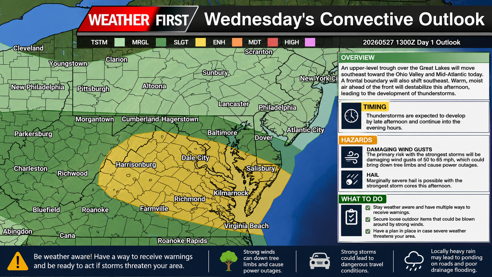
A more active weather pattern is expected to unfold across the Mid Atlantic today as a disturbance moving out of the Great Lakes pushes toward the Ohio Valley and East Coast. Forecasters are monitoring the potential for scattered strong to severe thunderstorms this afternoon and evening, especially across portions of Maryland, Delaware, Virginia, and southern Pennsylvania.
An upper level trough currently swinging southeast through the Great Lakes will help provide the energy needed for thunderstorm development later today. Early morning satellite and water vapor imagery already showed a lead disturbance tracking across southern Ohio into the central Appalachians, helping to spark areas of showers and thunderstorms ahead of the main system.
At the surface, a frontal boundary draped across the region has been reshaped by ongoing morning rainfall and thunderstorms. As this boundary gradually slides southeast through the day, warm and humid air ahead of it will continue building instability across the Mid Atlantic. Dewpoints climbing into the upper 60s and lower 70s will create a very moisture rich atmosphere capable of supporting stronger storms by this afternoon.
Clusters of thunderstorms to develop and move east southeastward later today. The primary threat with the strongest storms will be damaging wind gusts ranging from 50 to 65 mph, capable of bringing down tree limbs and causing isolated power outages. Some of the more intense storm cores may also produce small to marginally severe hail.
While widespread severe weather is not expected, scattered strong storms could become locally intense during the peak heating hours this afternoon into early evening. Residents across the region should stay alert for rapidly changing weather conditions and be prepared for possible severe thunderstorm warnings later today.
In addition to the wind threat, locally heavy rainfall may also accompany stronger storms given the humid environment already in place across the region.
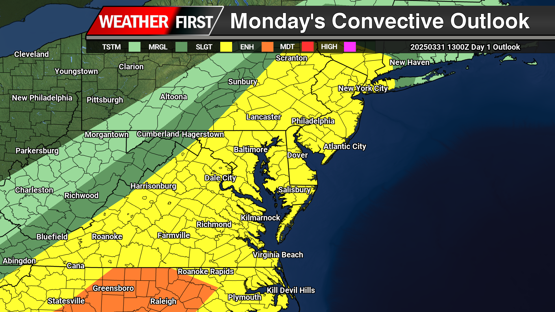
Strong to severe thunderstorms remain on tap as we venture into the afternoon and evening hours today as a strong cold front advances from the west. A “Slight Risk” of severe weather from the Storm Prediction Center laid across all of the Mid-Atlantic today.
Looking at satellite this morning over towards our west a nice blanket of sunshine moving into the region to help destabilize the atmosphere with surface heating as temperatures are expected to be well into the 70s as dew points surge into the 60s to have plenty of moisture in place. Well suited for thunderstorm develop later today.
The first round of storms will begin to develop across the Maryland Western shore around the mid-afternoon hours (4-5PM) which will have the highest chances of larger hail or even an isolated tornado being discrete in nature. Later in the evening hours as the cold front arrives, a squall line likely to develop with the primary threat of damaging straight line winds. Although a quick spin up in the line is always a possibility but those probabilities remain on the low side of things.
As mentioned before, the primary threat for the storms this afternoon will be indeed damaging straight line winds from the main squall line that moves through towards the evening hours from 7-10PM. Winds gusting as high as 70 mph are possible with the strongest portions of the line. Heavy rainfall from the squall line of 1-3″/hr could lead to some localized flooding in spots. During the mid afternoon hours when a few discrete cells form will have the best shot of large hail to 1″ or locally larger. Tornado threat remains low but not impossible for the first cells to develop in the afternoon hours and then again in the line itself.
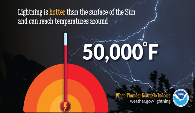
There is no safe place outside when thunderstorms are in the area. If you hear thunder, you are likely within striking distance of the storm. Just remember, When Thunder Roars, Go Indoors. Too many people wait far too long to get to a safe place when thunderstorms approach. Unfortunately, these delayed actions lead to many of the lightning deaths and injuries in the United States.
Lightning is a giant spark of electricity in the atmosphere or between the atmosphere and the ground. In the initial stages of development, air acts as an insulator between the positive and negative charges in the cloud and between the cloud and the ground; however, when the differences in charges becomes too great, this insulating capacity of the air breaks down and there is a rapid discharge of electricity that we know as lightning. There’s so much to learn about lightning.
Lightning kills about 20 people each year in the United States and hundreds more are injured. Some survivors suffer lifelong neurological damage. Here’s more information on the victims and the survivors.
Severe thunderstorms are officially defined as storms that are capable of producing hail that is an inch or larger or wind gusts over 58 mph. Hail this size can damage property such as plants, roofs and vehicles. Wind this strong is able to break off large branches, knock over trees or cause structural damage to trees. Some severe thunderstorms can produce hail larger than softballs or winds over 100 mph, so please pay attention to the weather so you know when severe storms are possible. Thunderstorms also produce tornadoes and dangerous lightning; heavy rain can cause flash flooding.
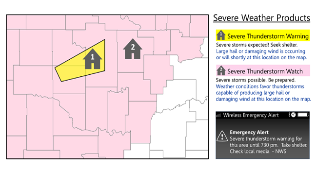
Do you know the difference between a National Weather Service Severe Thunderstorm Watch and a Severe Thunderstorm Warning? Check your knowledge below.
Severe Thunderstorm Watch: Be Prepared! Severe thunderstorms are possible in and near the watch area. Stay informed and be ready to act if a severe thunderstorm warning is issued. The watch area is typically large, covering numerous counties or even states.
Severe Thunderstorm Warning: Take Action! Severe weather has been reported by spotters or indicated by radar. Warnings indicate imminent danger to life and property. Take shelter in a substantial building. Get out of mobile homes that can blow over in high winds. Warnings typically encompass a much smaller area (around the size of a city or small county) that may be impacted by a large hail or damaging wind identified by an NWS forecaster on radar or by a trained spotter/law enforcement who is watching the storm.
Find out what you can do before severe weather strikes. Preparation is key to staying safe and minimizing impacts.
Be Weather-Ready: Check the forecast regularly to see if you’re at risk for severe weather. Listen to local news or a NOAA Weather Radio to stay informed about severe thunderstorm watches and warnings. Check the Weather-Ready Nation for tips.
Sign Up for Notifications: Know how your community sends warning. Some communities have outdoor sirens. Others depend on media and smart phones to alert residents to severe storms.
Create a Communications Plan: Have a family plan that includes an emergency meeting place and related information. Pick a safe room in your home such as a basement, storm cellar or an interior room on the lowest floor with no windows. Get more ideas for a plan at: https://www.ready.gov/make-a-plan
Practice Your Plan: Conduct a family severe thunderstorm drill regularly so everyone knows what to do if a damaging wind or large hail is approaching. Make sure all members of your family know to go there when severe thunderstorm warnings are issued. Don’t forget pets if time allows.
Prepare Your Home : Keep trees and branches trimmed near your house. If you have time before severe weather hits, secure loose objects, close windows and doors, and move any valuable objects inside or under a sturdy structure.
Help Your Neighbor: Encourage your loved ones to prepare for severe thunderstorms. Take CPR training so you can help if someone is hurt during severe weather.
Find out what you can do when severe weather strikes. Acting quickly is key to staying safe and minimizing impacts.
Stay Weather Ready: Continue to listen to local news or a NOAA Weather Radio to stay updated about severe thunderstorm watches and warnings.
At Your House: Go to your secure location if you hear a severe thunderstorm warning. Damaging wind or large hail may be approaching. Take your pets with you if time allows.
At Your Workplace or School: Stay away from windows if you are in a severe thunderstorm warning and damaging wind or large hail is approaching. Do not go to large open rooms such as cafeterias, gymnasiums or auditoriums.
Outside: Go inside a sturdy building immediately if severe thunderstorms are approaching. Sheds and storage facilities are not safe. Taking shelter under a tree can be deadly. The tree may fall on you. Standing under a tree also put you at a greater risk of getting struck by lightning.
In a Vehicle: Being in a vehicle during severe thunderstorms is safer than being outside; however, drive to closest secure shelter if there is sufficient time.
What should you do when the lightning and thunder stops and it looks likes the severe thunderstorm is over?
Stay Informed: Continue listening to local news or a NOAA Weather Radio to stay updated about severe thunderstorm watches and warnings. More severe thunderstorms could be headed your way.
Contact Your Family and Loved Ones: Let your family and close friends know that you’re okay so they can help spread the word. Text messages or social media are more reliable forms of communication than phone calls.
Assess the Damage: After you are sure the severe weather threat has ended, check your property for damages. When walking through storm damage, wear long pants, a long-sleeved shirt and sturdy shoes. Contact local authorities if you see power lines down. Stay out of damaged buildings. Be aware of insurance scammers if your property has been damaged.
Help Your Neighbor: If you come across people that are injured and you are properly trained, if needed, provide first aid to victims until emergency response team members arrive.
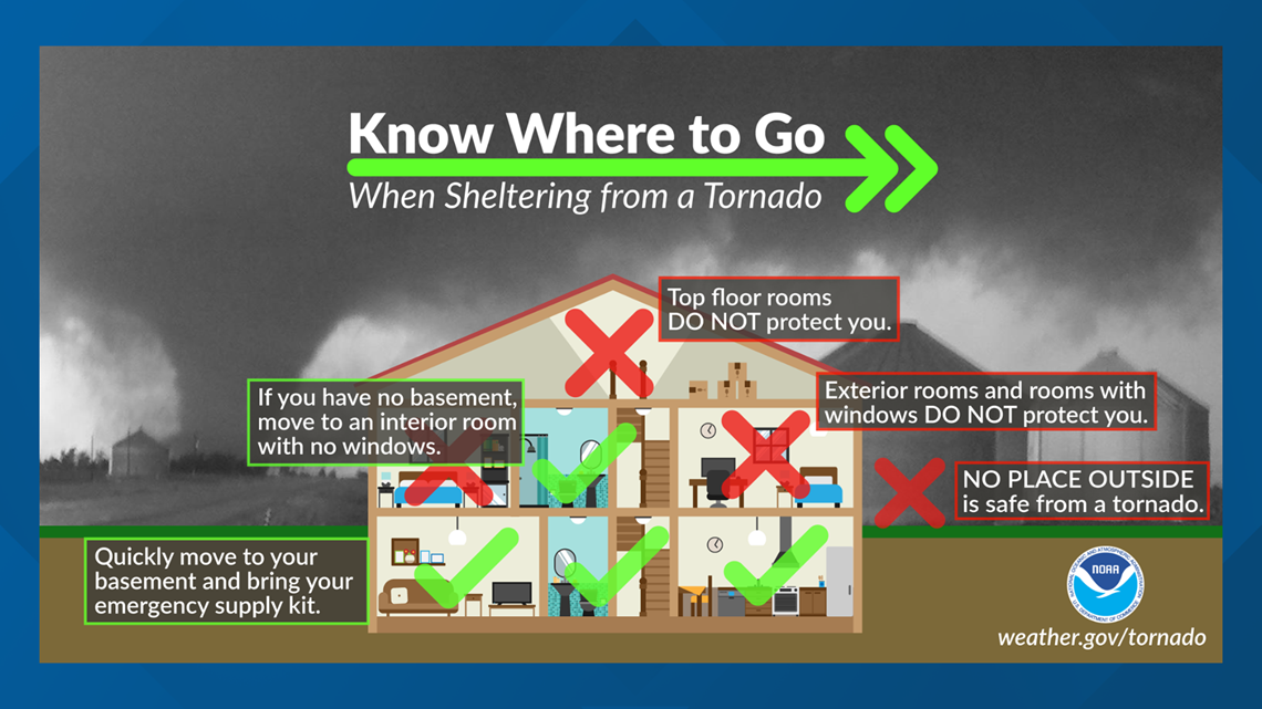
A tornado is a violently rotating column of air extending from the base of a thunderstorm down to the ground. Tornadoes are capable of completely destroying well-made structures, uprooting trees, and hurling objects through the air like deadly missiles. Tornadoes can occur at any time of day or night and at any time of the year. Although tornadoes are most common in the Central Plains and the southeastern United States, they have been reported in all 50 states.
What Are The Differences Between A Tornado Watch & Tornado Warnings
What is the difference between a Tornado Watch, a Tornado Warning and a Tornado Emergency? The National Weather Service has three key alerts to watch out for.
Tornado Watch: Be Prepared! Tornadoes are possible in and near the watch area. Review and discuss your emergency plans, take inventory of your supplies and check your safe room. Be ready to act quickly if a warning is issued or you suspect a tornado is approaching. Acting early helps to save lives! Watches are issued by the Storm Prediction Center for counties where tornadoes may occur. The watch area is typically large, covering numerous counties or even states.
Tornado Warning: Take Action! A tornado has been sighted or indicated by weather radar. There is imminent danger to life and property. Move to an interior room on the lowest floor of a sturdy building. Avoid windows. If in a mobile home, a vehicle, or outdoors, move to the closest substantial shelter and protect yourself from flying debris. Warnings are issued by your local forecast office. Warnings typically encompass a much smaller area (around the size of a city or small county) that may be impacted by a tornado identified by a forecaster on radar or by a trained spotter/law enforcement who is watching the storm.
Tornado Emergency: Seek Shelter Immediately! A tornado emergency is the National Weather Service’s highest alert level. It is issued when a violent tornado has touched down in the watch area. There is a severe threat to human life and property, with catastrophic damage confirmed. Immediately seek refuge in the safest location possible. Call friends and family who are within the watch area to ensure they are aware of the situation. If you see a tornado approaching, do not attempt to outrun it in a vehicle; shelter in place. Once safe, be sure to monitor your local forecast for the latest updates.
How To Prepare For A Tornado
Be Weather-Ready: Check the forecast regularly to see if you’re at risk for tornadoes. Listen to local news or a NOAA Weather Radio to stay informed about tornado watches and warnings. Check the Weather-Ready Nation for tips.
Sign Up for Notifications: Know how your community sends warnings. Some communities have outdoor sirens. Others depend on media and smart phones to alert residents of severe storms capable of producing tornadoes.
Create a Communications Plan: Have a family plan that includes an emergency meeting place and related information. If you live in a mobile home or home without a basement, identify a nearby safe building you can get too quickly, such as a church or family member.
Pick a safe room in your home, such as a basement, storm cellar, or an interior room on the lowest floor with no windows. Check more ideas for your family plan at: https://www.ready.gov/make-a-plan
Practice Your Plan: Conduct a family severe thunderstorm drill regularly so everyone knows what to do if a tornado is approaching. Make sure all members of your family know to go there when tornado warnings are issued. Don’t forget pets if time allows.
Prepare Your Home: Consider having your safe room reinforced. You can find plans for reinforcing an interior room to provide better protection on the Federal Emergency Management Agency website.
Help Your Neighbor: Encourage your loved ones to prepare for the possibility of tornadoes. Take CPR training so you can help if someone is hurt.
What To Do During A Tornado
Find out what you can do when a tornado strikes. Acting quickly is key to staying safe and minimizing impacts.
Stay Weather-Ready: Continue to listen to local news or a NOAA Weather Radio to stay updated about tornado watches and warnings.
At Your House: If you are in a tornado warning, go to your basement, safe room, or an interior room away from windows. Don’t forget pets if time allows.
At Your Workplace or School: Follow your tornado drill and proceed to your tornado shelter location quickly and calmly. Stay away from windows and do not go to large open rooms such as cafeterias, gymnasiums, or auditoriums.
Outside: Seek shelter inside a sturdy building immediately if a tornado is approaching. Sheds and storage facilities are not safe. Neither is a mobile home or tent. If you have time, get to a safe building.
In a vehicle: Being in a vehicle during a tornado is not safe. The best course of action is to drive to the closest shelter. If you are unable to make it to a safe shelter, either get down in your car and cover your head, or abandon your car and seek shelter in a low lying area such as a ditch or ravine.
What To Do After A Tornado Strikes
Stay Informed: Continue to listen to local news or a NOAA Weather Radio to stay updated about tornado watches and warnings. Multiple rounds of thunderstorms capable of producing tornadoes are possible during severe weather outbreaks.
Contact Your Family and Loved Ones: Let your family and close friends know that you’re okay so they can help spread the word. Text messages or social media are more reliable forms of communication than phone calls.
Assess the Damage: After the threat for tornadoes has ended, check to see if your property has been damaged. When walking through storm damage, wear long pants, a long-sleeved shirt, and sturdy shoes. Contact local authorities if you see power lines down. Stay out of damaged buildings. Be aware of insurance scammers if your property has been damaged.
Help Your Neighbor: If you come across people that are injured and you are properly trained, provide first aid to victims if needed until emergency response teams arrive.
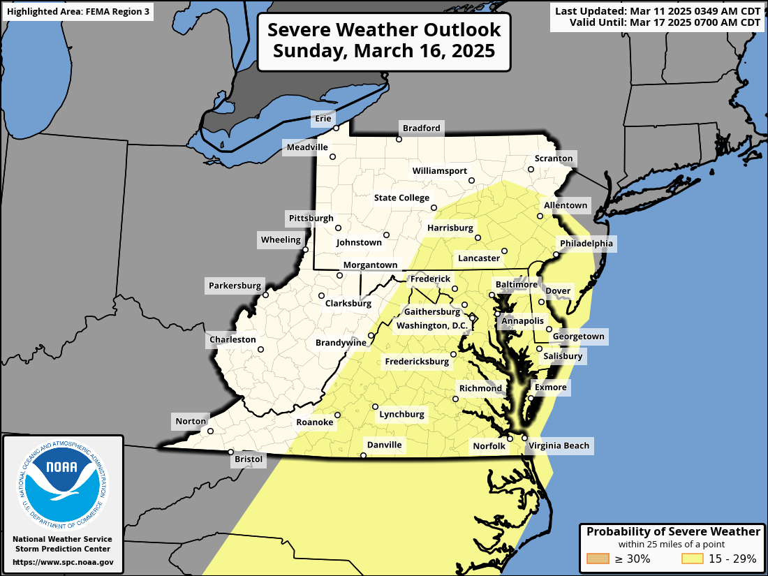
Once again another powerful storm system is expected to develop across the central lower 48 later this week posing a widespread multi-day severe weather outbreak with damaging winds, large hail, tornadoes, and another high wind event impacting millions across the country. The Storm Prediction Center has highlighted a “Slight Risk” of severe weather across the Mid-Atlantic region on Sunday for thunderstorms capable of producing damaging winds along a powerful cold front to swipe through the area.
Although areas across Delmarva and the surrounding areas will escape the extreme brunt of the severe weather, gusty thunderstorms are possible during the afternoon hours on Saturday where we have surface temperatures well above average into the lower 70s, sufficient moisture with dew points in the 60s, and not to mention the amount of wind shear available. Although the details remain unclear on the severity of the damaging winds or a tornado threat at this time, we will continue to monitor the threat as time gets closer.
With or without the presence of thunderstorms, strong non-thunderstorm winds will become a problem yet again with wind gusts 40-60 MPH are very possible when this front arrives. Enough to cause more issues with down tree limbs and sporadic power outages. Thunderstorms will only enhance the wind threat more similar to what we seen from last weeks event.
With a strong low level Jetstream reaching 50-70mph at 5000ft, some of those stronger winds could reach down to the surface at times with the gusty showers and embedded thunderstorms. We will continue to monitor the latest forecast trends as we approach closer towards the weekend.
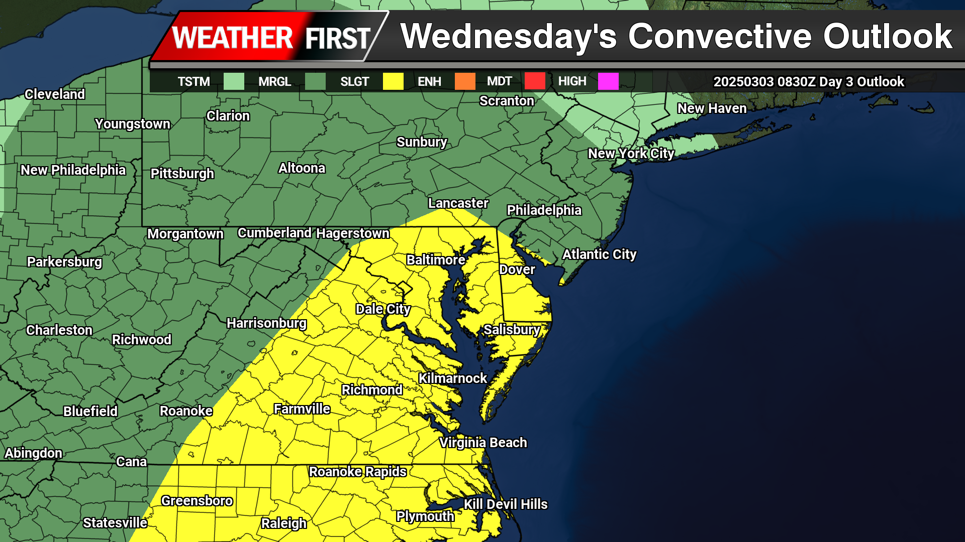
As a powerful storm system begins to develop across the Central Plains, rounds of severe weather are expected from the deep south towards the Mid-Atlantic. As the month turns a new, we are now in Meteorological Spring and the severe weather threats begin showing up across the country.
As a strong area of low pressure lifts up towards the Great Lakes, a tight pressure gradient will create tons of wind energy all over the eastern portions of the United States. On the warm side of the system as a powerful cold front advances eastward, instability and moisture coming from the Gulf will create a line of strong to severe thunderstorms to move through the Mid-Atlantic Wednesday afternoon.
A Slight Risk Of Severe Weather is in place across the Delmarva region down towards areas of the Carolinas. Primary threats will include strong damaging winds and the chance of a isolated tornado can not be ruled out. Storm Prediction Center meteorologist Jeremy Kerr had this to say about the overall threat.
   "Models indicate that surface dew points may increase into the 60s F
   in a corridor across the Carolinas through Virginia during the day.
   Latest NAM forecast soundings suggest that this might occur across
   parts of the Carolina Piedmont into coastal plain prior to the
   arrival of a remnant convective band emerging from the eastern Gulf
   States.  Although lower/mid-tropospheric lapse rates are forecast to
   be rather weak, weak near-surface destabilization might become
   sufficient to support a risk for tornadoes and/or damaging straight
   line wind gusts, given forecast very large, clockwise curved
   low-level hodographs.

   In the wake of this initial band of convection, beneath a developing
   dry slot, northward moisture advection and insolation to the lee of
   the Blue Ridge may contribute to modest destabilization by late
   Wednesday afternoon.  It appears that this will be aided by the
   leading edge of stronger mid-level cooling spreading to the east of
   the Appalachians, and accompanied by increasing thunderstorm
   development in the presence of strong deep-layer shear.  Although
   forecast soundings suggest that low-level hodographs may become more
   modest by this time as the stronger low-level jet core spreads
   offshore, the environment may still become conducive to supercells
   with potential to produce severe wind, hail and perhaps a tornado."
Including the threat for severe weather, high non-thunderstorm wind damage is possible with a strengthening low level jet stream across the region. Model guidance has been showing very strong low level Jetstream winds of 60-80kts at 5000 feet which can be brought down to the surface from heavy rain or thunderstorms.
As of this time, strong winds of 45 upwards to 60 mph are possible as this powerful cold front arrives during the afternoon hours on Wednesday. Winds of this magnitude can bring down trees and powerlines to create sporadic areas of power outages. Winds will continue to be strong after the cold front passes through as the pressure gradient remaining strong through Thursday.
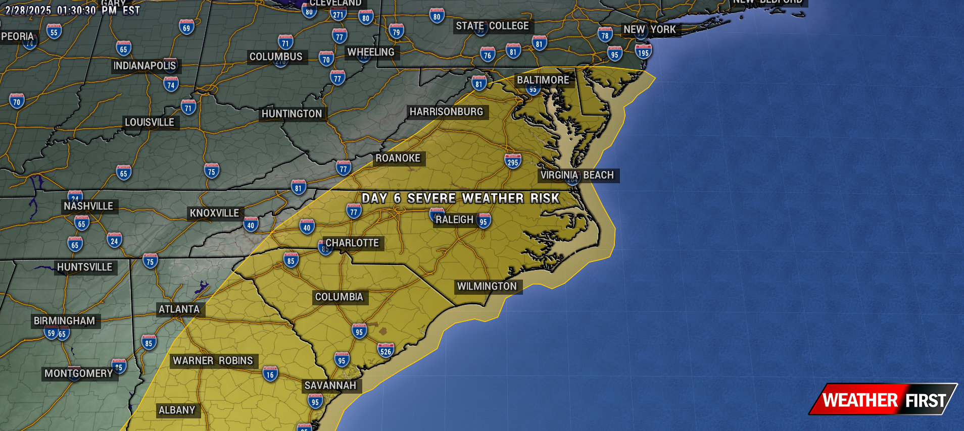
A major storm system is on the way across the Central Plains towards the East Coast bringing a plethora of heavy rain, severe weather and high winds. A severe weather risk from Tuesday-Wednesday where approximately 60 million people are in the threat regions for damaging winds, large hail, and the threat for tornadoes
The Storm Prediction Center center highlighting a 30% severe weather risk across Northern Lousiana towards Western Kentucky with a large 15% risk from Illinois towards the Gulf Coast Tuesday. Extending into the Mid-Atlantic and the Southeast US on Wednesday. SPC Meteorologist Jeremy Kerr had this to say about the storm threat next week.
” Spread typical at this extended time frame (day 5) lingers among the various model output concerning the sub-synoptic, and even synoptic, details across the southeastern Great Plains through Ohio Valley and Southeast, which may considerably impact the severe weather risk area and potential. However, the medium-range guidance depicts an environment at least conditionally supportive of an organized severe weather event, including potential for a few strong tornadoes and damaging straight line winds.
It is possible, but perhaps a bit more uncertain, that this could continue across parts of the southern and middle Atlantic Seaboard on Wednesday.”
While the threat for severe weather isn’t enough, this system will be quite the wind maker as well. A powerful Jetstream combined with a strong low level Jetstream of 60-80kts. Providing a lot of wind energy down towards the surface. And with the presence of thunderstorms, that wind threat may increase even more going forward.
As of now winds gusting 45-60 MPH are not out of the question come Wednesday which may lead to more episodes of down trees, and sporadic power outages. In the event of thunderstorms are in the mix, winds could become locally stronger bringing some of those powerful winds down to the surface.
As the snow continues to fall across Delaware, state officials are emphasizing safety measures for all residents. The Delaware State Police have issued a series of guidelines aimed at keeping motorists safe during the winter weather:
Stay Home if Possible: If you can avoid travel, do so. Conditions can be unpredictable and hazardous.
Drive Cautiously: For those who must travel, slow down, keep a safe distance from other vehicles, and ensure your vehicle is free of snow and ice to prevent accidents.
Emergency Preparedness: Carry an emergency kit in your car with items like blankets, a flashlight, food, and water. Check road conditions via official channels before setting out.
Respect Snow Plows: Do not attempt to pass or crowd snow removal vehicles. The Delaware Department of Transportation (DelDOT) crews are diligently working to clear the roads, and they need space to operate safely.
DelDOT has expressed gratitude towards their crews for their relentless efforts during the storm, urging the public to assist by not crowding the plows.
The Delaware Emergency Management Agency (DEMA) also reminds everyone to check on neighbors, particularly the elderly or those who might need assistance during this time.
With these safety tips in mind, Delawareans are encouraged to take extra precautions as the winter weather persists. Your safety, and the safety of those around you, is paramount.
PUBLIC INFORMATION STATEMENT
NATIONAL WEATHER SERVICE MOUNT HOLLY NJ
445 PM EDT THU JUL 14 2022

...NWS DAMAGE ASSESSMENT FOR JULY 12TH, 2022 THUNDERSTORM WIND EVENT...

.DENTON-HOBBS-ANDREWSVILLE-FARMINGTON MACROBURST...

PEAK WIND ESTIMATED:	110 MPH
PATH LENGTH /STATUTE/:  18 MILES
PATH WIDTH /MAXIMUM/:   4 MILES
FATALITIES:             0
INJURIES:               1

START DATE:             JULY 12, 2022
START TIME:             7:22 PM EDT
START LOCATION:         1.5 MILES SW DENTON, CAROLINE COUNTY, MARYLAND
START LAT/LON:          38.86/-75.85

END DATE:               JULY 12, 2022
END TIME:               7:57 PM EDT
END LOCATION:           4 MILES E FARMINGTON, SUSSEX COUNTY, DELAWARE
END LAT/LON:            38.87/-75.50

A MACROBURST BEGAN AROUND 7:22 PM EDT ABOUT 1.5 MILES SOUTHWEST OF
DENTON, MD IN CAROLINE COUNTY ALONG THE CHOPTANK RIVER. THE FIRST
AREA IMPACTED BY THE MACROBURST WAS AT MARTINAK STATE PARK WHERE
NUMEROUS TREES WERE DAMAGED. ONE TREE FELL ONTO A CAMPING TRAILER IN
THE CAMPGROUND RESULTING IN ONE MINOR INJURY TO AN OCCUPANT. A
PERSONAL WEATHER STATION JUST NORTH OF THE STATE PARK MEASURED A 70
MPH WIND GUST. THE PARENT STORM TRAVELED EASTWARD AND IMPACTED THE
HOBBS, MD AREA THEN CROSSED INTO FAR SOUTHWESTERN KENT COUNTY IN
DELAWARE WHERE IT CONTINUED TOWARD THE ANDREWSVILLE, DE AND
FARMINGTON, DE AREAS. ALONG THIS PATH, NUMEROUS AREAS SUSTAINED
CONSIDERABLE TREE AND UTILITY POLE DAMAGE ALONG WITH SOME
STRUCTURAL DAMAGE. NUMEROUS TREES WERE UPROOTED OR SNAPPED AND SOME
UTILITIES POLES WERE SNAPPED. A FEW STRUCTURES SUSTAINED
CONSIDERABLE ROOF MATERIAL AND ROOF STRUCTURE REMOVAL, INCLUDING A
FEW BARNS, FARM OUTHOUSES, AND CHICKEN HOUSES. AN UNUSED GRAIN SILO
AND A RESIDENTIAL TV ANTENNA TOWER WERE COLLAPSED. ONE HOME HAD A
COUPLE WINDOWS BLOWN OUT. THE STORM CONTINUED EASTWARD INTO NORTHERN
SUSSEX COUNTY EAST OF US ROUTE 13 WHERE IT BEGAN TO WEAKEN
CONSIDERABLY BY 7:57 PM EDT.

THE STRONGEST WIND GUSTS RESULTING IN THE DAMAGE CAUSED BY THIS
SEVERE THUNDERSTORM HAVE BEEN ESTIMATED TO BE AROUND 110 MPH.
2022 Severe Weather Season on Delmarva keeps delivering more and more destructive thunderstorms as the year goes on. From freak destructive hail across Dorchester and Wicomico counties back in May, Tornadoes in Western Maryland, to now one of the most destructive high wind events in several years across Caroline, Kent, and Sussex Counties.
Radar Loop From KDOX radar 7-8pm
So let’s dig into the atmosphere across the region on Tuesday. On Monday models where not handling the environment well what so ever with only a few isolated strong storms. It took until Tuesday morning to understand the environment was very conductive of a localized severe weather outbreak. If there was a checklist of what ingredients are needed to support destructive downburst winds, we had all the boxes checked for yesterday. We had very steep mid and low level lapse rates which is a combination alone supports great mixing of the atmosphere. A lapse rate is the rate of temperature change with height. The faster the temperature decreases with height, the “steeper” the lapse rate and the more “unstable” the atmosphere becomes. Plenty of moisture to work with the atmosphere with PWAT values exceeding 2 inches region wide. Precipitable water is the amount of water potentially available in the atmosphere for precipitation, usually measured in a vertical column that extends from the Earth’s surface to the upper edge of the troposphere.
Steep Mid Level Lapse Rates 700-500mb
Steep Low Level Lapse Rates – SFC – 700mb
High PWATS Exceeding 2 Inches
Unstable Enviroment of 1500 j/kg MLCAPE
30-50 KTS Wind Shear
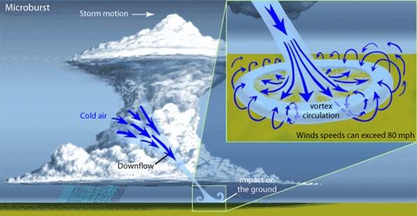
High moisture content within thunderstorm increases the chances for wet microbursts. A microburst is a localized column of sinking air (downdraft) within a thunderstorm and is usually less than or equal to 2.5 miles in diameter. Microbursts can cause extensive damage at the surface, and in some instances, can be life-threatening. We had enough instability in the atmosphere both at the surface level and into the mid portions of the atmosphere. CAPE values (Convective Available Potential Energy) were on the order of 1500 j/kg in the mid portions of the atmosphere and surface based CAPE on the order of 3000 j/kg. Those values indicate we have a modestly unstable airmass in place for vigorous thunderstorm development. And finally we have wind shear. With a trough digging in across the region we had sufficient wind shear up to 50kts to help sculpt and give these storms structure, as well as a source of stronger winds to tap into.
Diagram of Downbursts/Microbursts
Now that we got the environment sampled from yesterday, lets dive into the storm that caused prolific damage from Denton to Farmington.
Radar around 7:24pm Near Denton, MD
Our damage path started when we had a well defined line of storms started moving across Talbot county before moving into Caroline County around 7pm. Watching from the radar perspective, I started to notice a big increase in radar returns using Base Velocity. This tool is used to sample wind speeds within storms and they were accelerating very quickly southwest of Denton. I knew at that moment we got some major issues on our hands. I sent out a alert to residents from Denton to Farmington to seek a sturdy shelter immediately knowing we have significant Microburst in progress. At this moment only a base level Severe Thunderstorm Warning was issues for the region for winds of 60 mph. Which at this point, radar return showing surging winds of 80-90 mph around 1000 feet above the ground. Significant wind damage was already in progress with power poles snapped, large trees uprooted and some structural damage. Even one confirmed injury with a gentlemen suffering a concussion when taking shelter in a Camper in Denton. Where he was thrown with his camper from the strong winds and a tree falling on it. He is in stable condition which is great news.
Radar View From Andrewsville On The MD/DE Line
Our storm begins to gain intensity as it crosses over the MD/DE line into Andrewsville. Radar signatures still holding steady with 80-90 MPH winds roughly at 800ft above the surface. Many reports out that way of power poles being snapped, significant tree damage with several roofs being blown off from chicken houses and outbuildings. Consistent with ongoing radar returns, significant straight line winds were continuing to rip across the county in Kent & Sussex counties.
Radar Snapshot ~ 7:38PM – Radar Returns Reaching 100 MPH Around 700ft In Harrington / Farmington
Now we enter I would say the max intensity of this destructive wind even near the Harrington region where I have seen some of the worst damage. With radar coverage so close to where this storm occurred, it was a blessing to have such incredible radar data to judge the strength of these winds. At this point when a rare “Destructive Severe Thunderstorm Warning” was issued for areas of Kent and Sussex Counties.
These are new type of warning from the National Weather Service to be issued to give greater threats to thunderstorms who are capable of destructive winds or hail. Winds need to be at least 80 MPH or hail greater than the size of baseballs. These warnings will trigger mobile phones similar to how you would receive a Tornado Warning for your area. This is our second SVRD to the Delmarva region this year with the last one occurring in May across Ocean City Maryland. Damage across Harrington include several structures losing roofs and one pole barn suffered a full collapse on the rear side. Debris were thrown hundreds of feet into other homes and opens fields. Several power poles snapped along Route 14.
Slaughter Neck, DE 2021 – EF1 90 MPHTiffany Clarie – Harrington, DE
A resident with a TV antenna tower folded under the power of the winds yesterday. Now those take some very strong winds to topple over. Last year in Milford through Slaughter beach, a EF-1 tornado caused similar wind speeds of at least 90 mph to topple one of these. The only difference the one in Slaughter Neck was twisted at the point of the failure where as Tiffany had in Harrington was folded in the same direction of the wind. 90-100 MPH of Straight Line Winds appear likely through this region in reference to radar data to support it. Goes to show that you do not need a tornado to create significant damage. Straight lines of this magnitude are similar to a EF-1 tornado and can cause significant threat to lives and property.
A big thank to everyone who sent us photos and information for this case study of the destructive winds across our region.
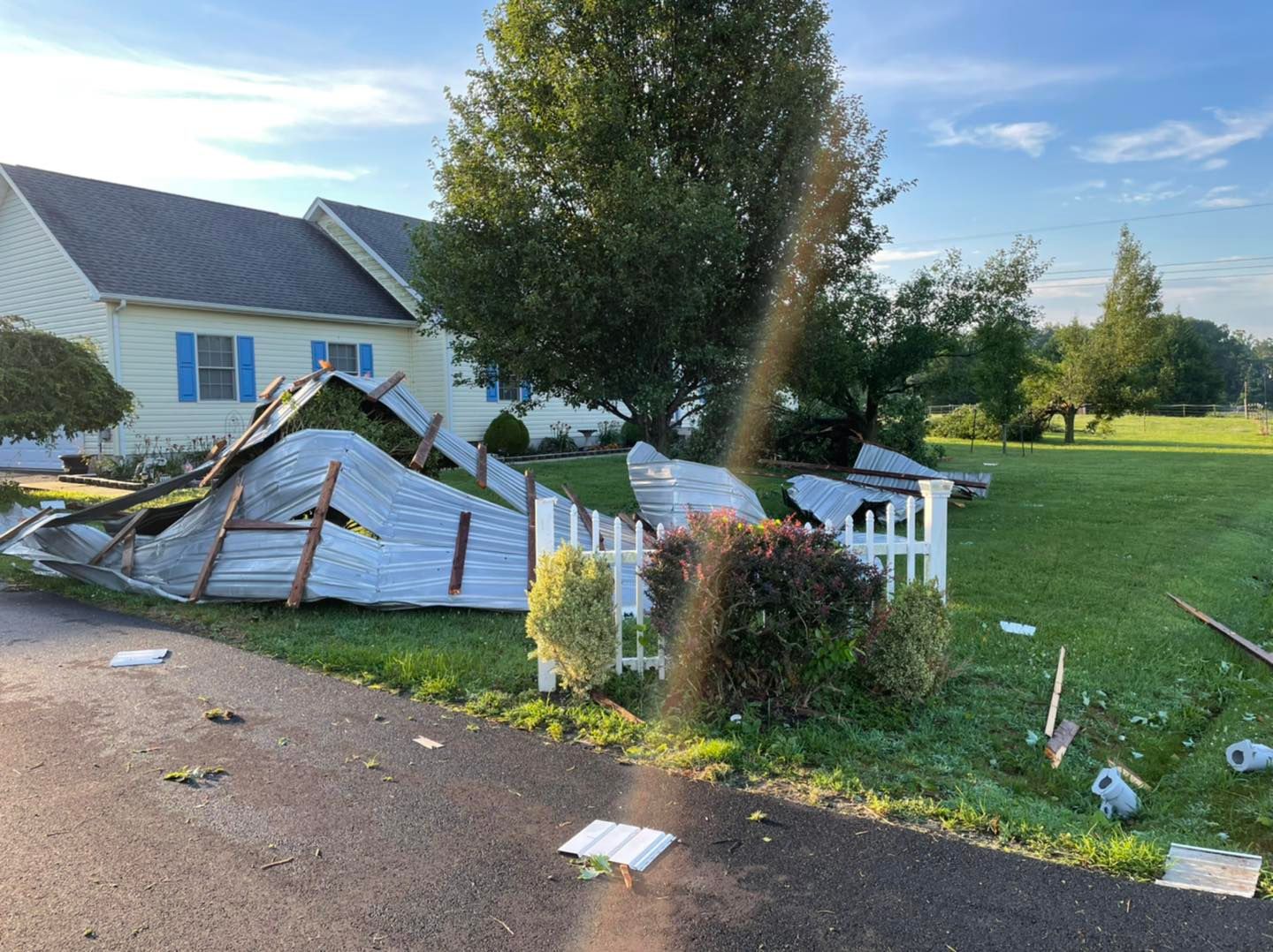
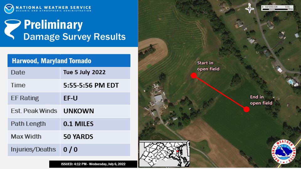
END DATE: JUL 5 2022 END TIME: 556 PM EDT END LOCATION: 1 N HARWOOD MD END LAT/LON: 38.895/-76.597
A SUPERCELL THUNDERSTORM SPAWNED A BRIEF TORNADO JUST NORTH OF HARWOOD, MD (4 SOUTHWEST OF LONDONTOWNE) IN ANNE ARUNDEL COUNTY LATE TUESDAY AFTERNOON JULY 5, 2022, BETWEEN 5:55 AND 5:56 PM EDT.
THIS SUPERCELL ORIGINALLY DEVELOPED ALONG THE HOWARD/MONTGOMERY COUNTY LINE AS A RESULT OF A REMNANT MESOSCALE CONVECTIVE VORTEX (MCV) MOVING THROUGH THE REGION WHICH HAD EARLIER MOVED THROUGH THE OHIO VALLEY EARLIER IN THE DAY. IT EVOLVED INTO A CLUSTER OF CELLS INITIALLY BEFORE SPLITTING OFF INTO AN INDIVIDUAL SUPERCELL THAT WOULD DEVELOP ROTATION AS IT MOVED OUT OF SOUTHEASTERN MONTGOMERY COUNTY INTO NORTHWESTERN PRINCE GEORGES COUNTY. THE CELL DROPPED A TORNADO EARLIER IN THE AFTERNOON NEAR BOWIE, AND WOULD THEN CYCLE TO PRODUCE THE SECOND TORNADO IN HARWOOD.
A BROADCAST MEDIA PARTNER PROVIDED VIDEO AND EYEWITNESS EVIDENCE OF A BRIEF SPIN-UP TORNADO WHILE LOCATED AT THE INTERSECTION OF BIRDSVILLE RD AND SOLOMONS ISLAND RD. THIS INDIVIDUAL NOTED THAT THE TORNADO WAS LOCATED JUST TO THEIR NORTH IN AN OPEN FIELD AND WAS ON THE GROUND FOR ABOUT ONE MINUTE.
KLWX WSR-88D DOPPLER RADAR IN STERLING VA DEPICTED A BRIEF VELOCITY COUPLET THAT CORRESPONDED TO THE LOCATION OF THE VIDEO DESCRIBED ABOVE.
THE BALTIMORE/WASHINGTON WEATHER FORECAST OFFICE IN STERLING, THANKS OUR BROADCATST MEDIA PARTNERS WHO WERE ABLE TO PROVIDE EVIDENCE OF A TORNADO ON THE GROUND.
EF SCALE: THE ENHANCED FUJITA SCALE CLASSIFIES TORNADOES INTO THE FOLLOWING CATEGORIES:
EFU.........UNKNOWN WIND SPEED EF0.........65 TO 85 MPH EF1.........86 TO 110 MPH EF2.........111 TO 135 MPH EF3.........136 TO 165 MPH EF4.........166 TO 200 MPH EF5.........>200 MPH
I will start off to say we for sure had a unicorn of hail storm here across areas of Delmarva. I’ve been studying a lot of storms over the years across Delmarva and this one was in the top tier of hail storms for the sure because of the damage it caused just from the hail alone.
Cloud Phase Distinction Satellite Of The Supercell
Let’s start off with the elephant in the room that this was a long tracked supercell thunderstorm as discrete as you could possibility get. Didn’t have to share resources with other storms in the environment. And I’m going to be real with you, the environment this storm was in for what it produced is actually astonishing. Storms of this magnitude producing widespread 2in diameter hail or greater for this long duration is something you would normally see out in the central plains. With the very cold air aloft and the very unstable atmosphere. Our supercell yesterday was only under 1500 j/kg of MLCAPE where storms I’ve normally seen with this kind of hail has at least twice that if not more. This one lone supercell took advantage of a disturbed free environment all to itself and used the maximum instability the region had. Not to mention tapping in the the 50kt bulk shear in the region to keep supercellular characteristics
Hail Streak Across Western Shore Of Maryland & Central Delmarva
This storm first developed just the west of Washington D.C as a single cluster before taking off as a HP Supercell throughout Prince Georges and Calvert County. Confirmed multiple locations with > 2in diameter hail with a single report of 3in in Diameter in Chesapeake Beach in Calvert County. Before moving across the Chesapeake keeping the same intensity across Delmarva.
Cross Section & SFC Radar In Dorchester County
Here’s what took me by surprise. Normally getting large hail of this size, you need a storm that is very tall in the atmosphere. On radar estimates, we had on average 40-45 kft (40-45,000 feet) cloud tops with one singular overshooting top to 45 kft. Normally seeing 2in hail you need very cold cloud tops closer to 50-55kft and cold temperatures aloft which is something we do not get here in the warmer seasons. Looking at radar from KDOX and GOES-16 Satellite we had one persistent updraft on the southern side of the storm. The hail core was astonishing. We had the updraft all the way to the very top of the storm at 40kft which is amazing for how small of an area it covered.
Keep in mind I want to share with you the logistics of how strong of a updraft is needed to suspend >2in hail in a storm. For the reported 2 to 3 in Diameter hail you need a updraft speed of 70-85 MPH upward velocity. Looking at some the hail sizes and shapes we have a mixture of round and spikey hail meaning there has been some warmer air with some melting on the way up. Even more evidence that there was some strong upward forcing of water molecules in this small but potent updraft.
James Phillips Jr / East New MarketCory Polidore / Linkwood, MDMegan Elzey / Linkwood, MDLianne Hosmer / Laurel, DE
Impressive damage across areas of Dorchester and Western Sussex County from this one storm yesterday. Severe damage to vehicles, windows blown out, siding a complete loss. Not to mention reports of a hail accumulations for areas around Cambridge. Very common for hail sizes around baseballs causing significant damage to property.
Average of >2in Hail Events In The US. Delmarva Is At The Bottom Of The Scale
Goes to show you, Delmarva can defy the odds of getting Central Plains type of storms. Whether it’s a tornado outbreak, a derecho or in our case this time around, a severe hail event. Always remember, it can only take one storm to make a disaster. We had a very rare event happen yesterday that unfortunately had some devastating consequences. Luckily nobody was hurt and property can be rebuilt.
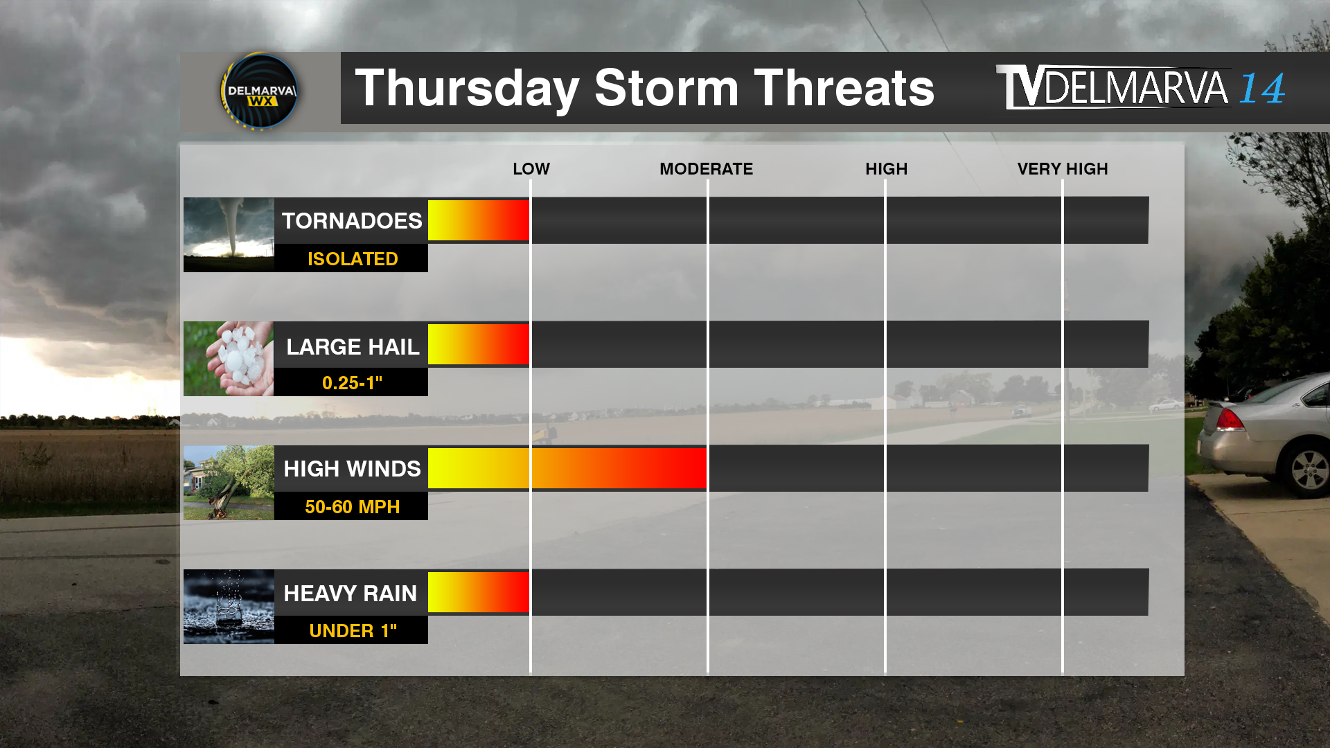
While we are now in the short term model guidance, we had a big shift in the timing of this event. On Tuesday many of the medium range model guidance showed this event to be extremely underwhelming and much later into the night. Now into Wednesday, we have pushed the timing up about 6-8 hours into the afternoon and evening hours on Thursday. That big shift in timing boosted our chances to match with the SPC’s Slight Risk of Severe Weather they had all week.
A good agreement between the HRRR/RAP as well as the CAMS showing ample thunderstorm development across the Mid-Atlantic States. An increase in instability as well with dew points going into the lower 60’s. Storms should be developing from west to east from 2-10pm.
With the main threat being wind damage within these storms. No surprise with the strong winds aloft and in the lower level Jetstream. Strong winds at 5000 feet of 60-70 kts giving ample speed shear for storms to produce some gusty downbursts. Using TEHI for the tornadic threat and the good news is once more, fairly low probabilities. TEHI values under 2 (20%) chance of these storms producing a tornado in this environment. Also when we take a look at the Updraft Helicity Streaks, there is very little if any which is good news for shows storms with potential rotation on the models.
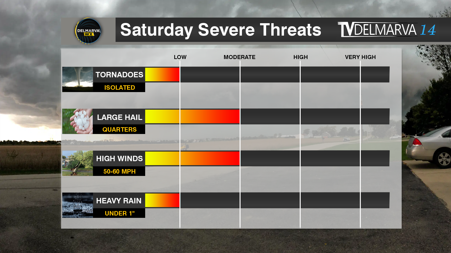
We are getting closer and closer to our typical Severe Weather Season here on the shore. And we get a bit of a taste for it on Saturday. Now here’s the setup we are looking at.
Low Pressure system Over The Great Lakes Driving A Cold Front Through The Eastern US
First off we have a fairly strong area of low pressure moving across the Great Lakes region with a strengthening mid level Jetstream across the Mid-Atlantic States. That’s the first set of ingredients for the storm setup for tomorrow.
Futurecast With Forecasted Dew Points | Sufficient for Storm Development
Now storm formation will be isolated in nature based on the latest high resolution model guidance. One thing is for sure we got the warmer temperatures and bit of surface moistures with dew points getting into the 60’s. So it’s going to be a little bit muggy out there by the early afternoon hours.
Model Outputs Regarding Instability and Wind Shear
Now we will see ample instability and wind shear across the region before our cold front arrives during the evening hours. MLCAPE (a product used to measure instability) showing values in the moderate instability category which is very crucial for thunderstorm development. Not to mention with the decent amount of instabilty, mid level lapse rates are fairly steep as well. Anytime we get Lapse Rates in the mid levels over 7C/km, that increases our hail threat just a bit with the colder air higher into the atmosphere. This is why we have a bit of a higher threat for seeing quarter size hail in storms that may develop. Not to mention we have some decent bulk shear (wind shear in a storm environment). 50-60kts is more than plenty to get a mix of line segments or even a couple of isolated supercell thunderstorms.
Brand New Product To Help Forecast Tornado Threats | Forecast Slice Through The Atmosphere
Now in production for a little while, we have been working very hard at developing to really narrow down tornado threats in a 0-10 scale (0-100%). We are testing the waters on this one since there is a little bit of a tornado threat going into tomorrow. our TEHI product showing a level 1-2 threat out of 10 for tornadoes here on the shore. meaning storms will have a 10-20% chance of producing a tornado. Low level environment showing sufficient turning in the lowest levels which is very important for tornadogenisis.
One limiting factor for storms tomorrow is the time of year we are in. Our coastal water temperatures do play a role in our storm threats with them being in the upper 40’s. This can create some stable air near the surface and cause storms to climb upscale and scrapping any tornado threat all together.
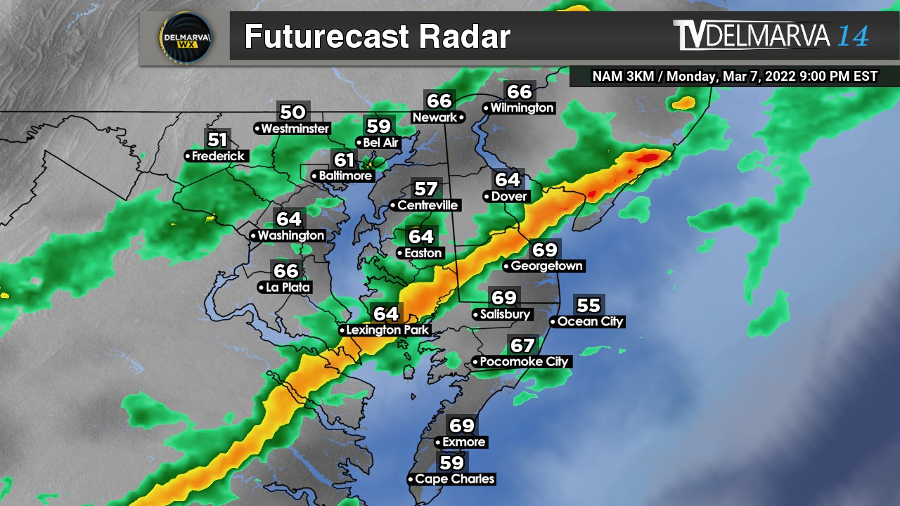
With the extremely warm temperatures on this March day here on the shore, we have a strong cold front on the move this evening. With barely any instability in place today, this storm threat is strong shear dominate. We have the chance of some storms that could reach severe limits during the evening hours today. Computer guidance has been hinting at a thin squall line to develop along the front with already very strong surface winds expected today.
Slight Risk of Severe Weather For Northern Delmarva and Northern Maryland
The biggest driver for today’s Slight Risk of Severe Weather is the very strong low level shear and steep lapse rates. With strong winds fairly close to the surface and with a strengthening low level jet to 60 knots, when that front arrives some of those stronger winds aloft will be brought down to the surface.
Steep Low Level Lapse Rates indicating some great mixing of the stronger winds aloft to be brought down to the surface.
Anytime you see Lapse Rates greater that 7.5 in the lowest levels, that’s the perfect case scenario for a damaging wind potential. Damaging winds are really the only threat with today’s setup. Tornado threat is very low today because the wind direction throughout the atmosphere is very linear. Tornadoes need turning wind form the surface on up.