Tag: polar vortex

  • Polar Vortex Split Bringing Arctic Outbreak Starting Next Week

    Polar Vortex Split Bringing Arctic Outbreak Starting Next Week

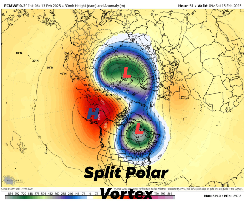
    A significant meteorological event is poised to impact the contiguous United States next week, as the stratospheric polar vortex undergoes a rare split, leading to an arctic outbreak with temperatures projected to plummet 20 to 40 degrees below normal between February 17th and 23rd.

    Understanding the Polar Vortex Split

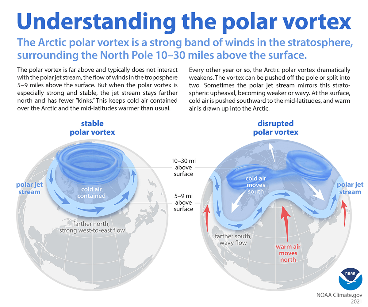
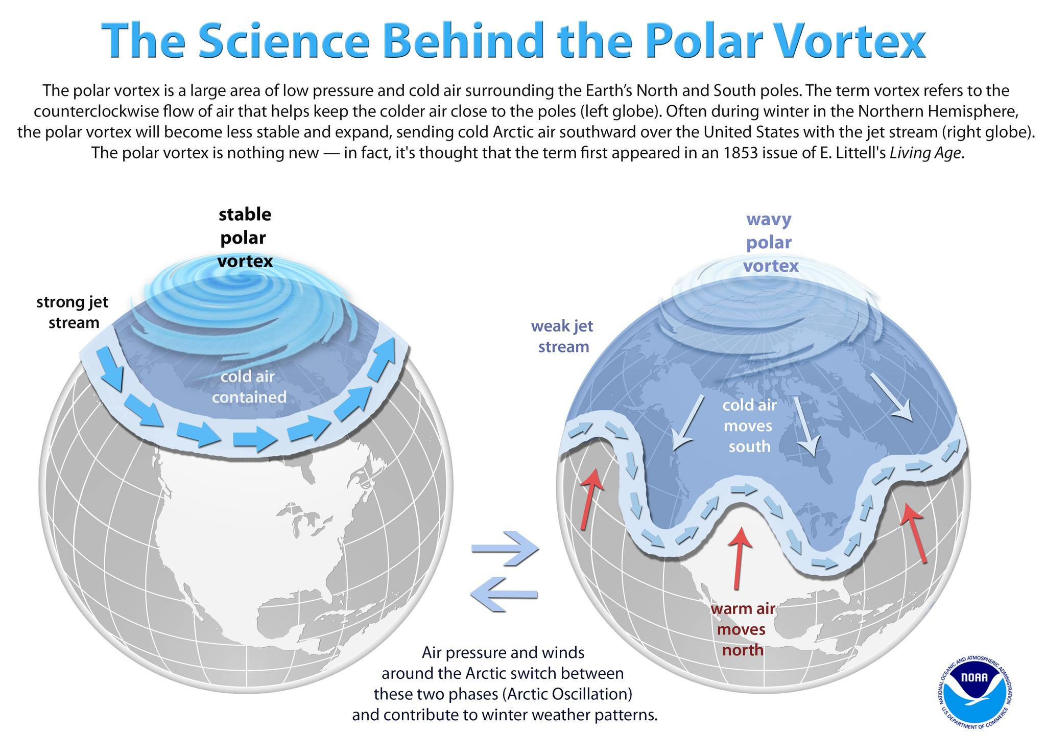
    The polar vortex is a large area of low pressure and cold air surrounding both of Earth’s poles, residing in the stratosphere. Typically, this vortex remains stable, containing the cold air within the polar regions. However, certain atmospheric conditions can disrupt this stability, leading to a phenomenon known as a Sudden Stratospheric Warming (SSW). During an SSW, large-scale atmospheric waves, called Rossby waves, propagate into the stratosphere, weakening the polar vortex. If these waves are strong enough, they can cause the vortex to split into two or more smaller vortices. This split allows frigid polar air to descend into mid-latitude regions, including parts of the United States.

    Projected Temperature Anomalies

    Forecast models, including the European Centre for Medium-Range Weather Forecasts (ECMWF) and the Global Forecast System (GFS), indicate that one of the split vortex cores will migrate over North America. This movement is expected to usher in a significant cold air outbreak across the northern, central, and eastern United States. Temperature anomalies during this period are projected to range from 20 to 40 degrees below normal.

    Potential for Increased Winter Storm Activity

    The influx of arctic air sets the stage for enhanced winter storm development. As the cold air interacts with warmer, moisture-laden systems from the south, the likelihood of snow, ice, and mixed precipitation events increases. Regions across the central and eastern U.S. should prepare for potential winter storms during this period, with the possibility of significant snowfall and hazardous travel conditions.

    Preparing for the Arctic Outbreak

    Residents are advised to monitor local weather forecasts and heed warnings from meteorological authorities. Preparations should include:

    • Ensuring adequate heating supplies and checking the functionality of heating systems.
    • Stocking up on essential items in anticipation of potential disruptions.
    • Taking necessary precautions for vulnerable populations, including the elderly and those with health conditions.
    • Preparing vehicles for winter conditions, including checking antifreeze levels and ensuring tires are suitable for snow and ice.

    By staying informed and taking proactive measures, individuals and communities can mitigate the impacts of this impending arctic outbreak.

  • Major Changes Ahead: Stratospheric Polar Vortex Split Could Bring An Active Winter Pattern Back to the U.S. Mid Month

    Major Changes Ahead: Stratospheric Polar Vortex Split Could Bring An Active Winter Pattern Back to the U.S. Mid Month

    As we head into mid-February, significant changes are brewing in the upper atmosphere that could have major implications for winter weather across the United States. The stratospheric polar vortex, a large-scale circulation of frigid air in the upper levels of the atmosphere, is undergoing a split, with one lobe shifting over North America and the other over Eastern Russia. This development could mean that winter is far from over for the Lower 48, with renewed bursts of Arctic air and even the potential for more snow.

    What is the Polar Vortex?

    The polar vortex is a vast region of cold, low-pressure air that resides in the stratosphere above the Arctic. It is typically strongest in winter and is contained by the polar jet stream, which acts as a barrier, keeping the frigid air locked in place. However, disturbances in the atmosphere, such as sudden stratospheric warming (SSW) events, can weaken or even split the polar vortex, allowing cold Arctic air to spill southward into mid-latitude regions, including the United States, Europe, and Asia.

    The Implications of a Polar Vortex Split

    When the polar vortex splits, the disrupted circulation can send lobes of cold air into different parts of the world. In this case, one portion of the vortex is expected to shift over North America, while the other moves over Eastern Russia. This could lead to:

    • Bitter Cold Spells: A more active intrusion of Arctic air into the U.S., potentially bringing below-average temperatures to much of the country, including regions that have recently experienced milder conditions.
    • Increased Snowfall: With cold air in place, any developing storm systems could tap into this frigid air mass and produce widespread snowfall across parts of the Midwest, Northeast, and even the South.
    • Disruptive Weather Patterns: A disrupted polar vortex can lead to more extreme weather events, including stronger storms, ice events, and even severe weather outbreaks as cold air clashes with milder air masses to the south.

    What to Expect Mid-Month

    As we approach mid-February, long-range models suggest a greater likelihood of colder air descending into the central and eastern U.S., potentially bringing another round of winter weather. The exact details remain uncertain, but if history is any guide, a significant polar vortex split often leads to prolonged cold outbreaks lasting several weeks.

    For those who thought winter was winding down, this development is a strong reminder that the season isn’t over just yet. Stay tuned for further updates as meteorologists track the evolving polar vortex split and its potential impacts on the weather in the coming weeks.

  • Cold & Stormier Ringing In The New Year

    Cold & Stormier Ringing In The New Year

    To most of you this just looks like a bunch of lines on a graph. To me this is a pure (Mwah Chef’s Kiss) for someone who is a fan of cold and stormy going into the New Year. And right now the forecasted teleconnections across the Northern Hemisphere are as good as it gets.

    What are teleconnections? Teleconnections are significant relationships or links between weather phenomena at widely separated locations on earth, which typically entail climate patterns that span thousands of miles. Many teleconnection patterns behave like a seesaw, with atmospheric mass/pressure shifting back and forth between two distant locations.

    So going forward we have a -AO (Arctic Oscillation) which promotes something known as Cross-Polar Flow bringing colder air from Siberia down into North America.

    A -NAO (North Atlantic Oscillation) which promotes high latitude blocking across Greenland which helps slows down the jet-stream pattern. This allows storm to deepen and strengthen across the country.

    A +PNA (Pacific North-American Oscillation) promotes ridging across the Western US, and on the opposite end brings troughs to the east for storm systems to follow.

    And we also throw in a -EPO (Eastern Pacific Oscillation) which works with the PNA to promote ridging in the Eastern Pacific which helps allows cross polar flow down in the Eastern US.

    All these together is the ingredients to start bringing up the chances for some snowstorms in the east after the New Year! Not to mention, we have a SSW (Sudden Stratospheric Warming) occuring which will help break down the Polar Vortex and displace cold air southward to the Middle Latitudes. This is the response to what the teleconnections are forecasted to do here in the next few weeks.

    If you are fan of cold and stormy weather, this is the pattern for you hands down!

  • Warming In The Stratosphere: Busy Second Half Of Winter?

    Warming In The Stratosphere: Busy Second Half Of Winter?

    Second half of winter just keeps looking better and better. El Nino winter’s alone are notorious for second half winter fun for the country. And now we have another parameter to throw into place. Welcome to Polar Vortex!

    “The polar vortex is a large area of low pressure and cold air surrounding both of the Earth’s poles. It ALWAYS exists near the poles, but weakens in summer and strengthens in winter. The term “vortex” refers to the counter-clockwise flow of air that helps keep the colder air near the Poles. Many times during winter in the northern hemisphere, the polar vortex will expand, sending cold air southward with the jet stream. This occurs fairly regularly during wintertime and is often associated with large outbreaks of Arctic air in the United States. The one that occurred January 2014 is similar to many other cold outbreaks that have occurred in the past, including several notable colder outbreaks in 1977, 1982, 1985 and 1989.”

    So what is going on is that we are see a potential major warming of the stratosphere near the polar region going into the New Year. So what does that mean and how in the world do we get cold air from a “Warming” event. Think of like a bath tub separated in half with one side of very cold water and one side very warm water. When introducing the warmer water to the very cold side what happens? The cold water gets displaced and in the atmosphere, that cold air sinks south which overall weakens and breaks down this cold vortex in the polar regions.

    Sudden Stratospheric Warming events take time to do it’s thing. Typically 2-3 weeks before we can see the influence of the global weather pattern, but the effects can last for 1-2 months. As I have been mentioning or quite awhile now, we just have to be patient this winter. Second half of January into February keeps looking more and more interesting. 🌬🌨☃️