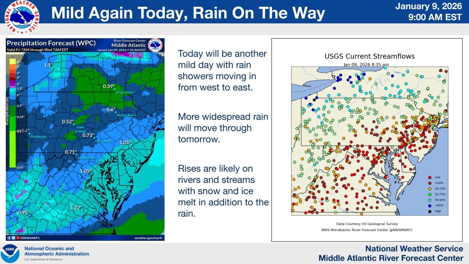
A prolonged period of unsettled weather is expected to impact much of the Mid Atlantic beginning later this evening and continuing through Sunday, bringing multiple rounds of rain and the potential for localized flooding concerns.
Rain showers will begin moving into the region from west to east this evening as a mild and moisture rich weather pattern remains in place. While rainfall tonight is expected to be generally light to moderate, coverage will increase overnight and into Saturday as a stronger system approaches.
More widespread rain is forecast for Saturday and Saturday night as deeper moisture moves into the Mid Atlantic. Periods of steady rain are likely, with occasional heavier downpours. Embedded isolated thunderstorms are also possible during this time, which could briefly enhance rainfall rates in some areas.
By Sunday, additional rounds of showers are expected to continue, keeping soils saturated and rivers on the rise. While rainfall amounts will vary by location, several areas could see one to two inches of rain by the end of the weekend, with locally higher totals where heavier showers or thunderstorms occur.
Delmarva Region Faces Elevated Rain And Water Concerns
Across the Delmarva Peninsula, including Delaware, eastern Maryland, and the Eastern Shore of Virginia, the rain threat will become more pronounced overnight and persist through the weekend. Rainfall totals of one to two inches are likely across much of the region, with isolated higher amounts possible.
The combination of steady rain, mild temperatures, and ongoing snow and ice melt farther north could lead to noticeable rises on rivers, streams, and creeks. Low lying and poor drainage areas may be especially susceptible to ponding of water, particularly during periods of heavier rain.
While widespread flooding is not currently expected, localized minor flooding cannot be ruled out, especially if thunderstorms produce brief heavy downpours. Urban areas and locations near small waterways should remain alert for changing conditions.
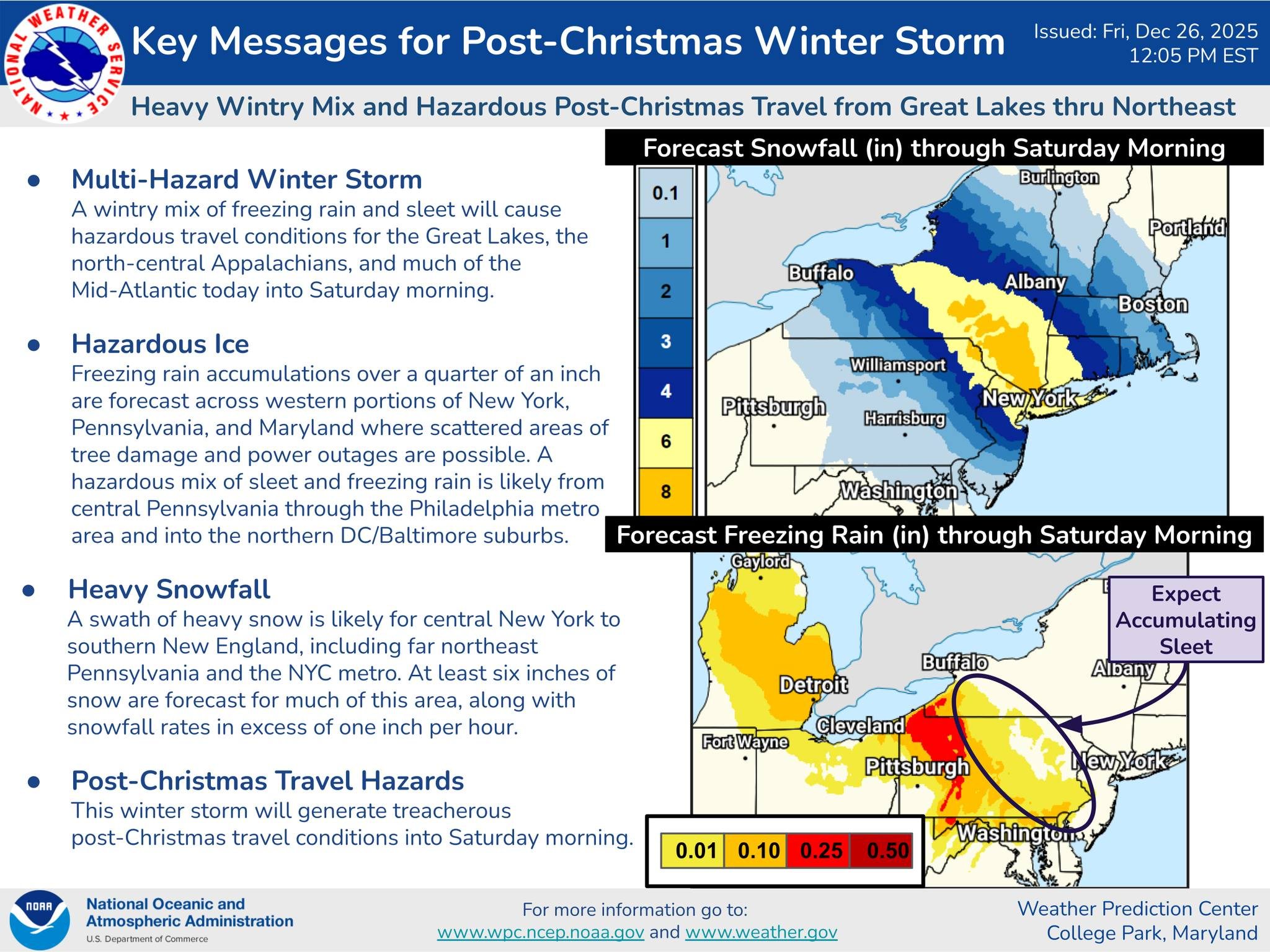
A significant post-Christmas winter storm is expected to create hazardous conditions from the Great Lakes through the Mid-Atlantic and into the Northeast through Saturday morning, bringing a complex mix of snow, sleet, and freezing rain that will heavily impact travel and infrastructure across the region.
According to the Weather Prediction Center, this is a multi-hazard winter storm, with the most dangerous impacts tied to ice accumulation and heavy snowfall. A swath of heavy snow is forecast from central New York into southern New England, including portions of northeastern Pennsylvania and the New York City metro area. Many of these locations could see six inches or more of snow, with snowfall rates exceeding one inch per hour at times, leading to rapidly deteriorating road conditions.
Farther south, the primary concern shifts from snow to ice. Freezing rain and sleet are expected to dominate across portions of Pennsylvania, western and central Maryland, and parts of the Mid-Atlantic, creating a dangerous glaze on untreated surfaces. Ice accumulations over a quarter inch are possible in some areas, increasing the risk for tree damage and scattered power outages.
Northern Maryland Impacts
Northern Maryland, including areas near and north of the Baltimore metro, is expected to be near the transition zone between snow and freezing rain. This setup raises the risk for significant sleet accumulation followed by freezing rain, which can be particularly hazardous for travel. Roads may quickly become icy, even where surface temperatures hover near freezing. Elevated surfaces such as bridges and overpasses will be especially prone to icing. Any ice buildup on trees and power lines could result in localized outages and downed limbs.
Northern Delmarva Concerns
Across northern Delmarva, including Cecil County, Kent County, and areas near the upper Chesapeake Bay, a wintry mix of sleet and freezing rain is expected to develop, particularly late Friday into Friday night. While snowfall totals are likely limited, even light ice accretion could significantly impact travel along major corridors such as I-95, U.S. Route 13, and local secondary roads. Gusty winds combined with ice may further stress trees and utility lines, increasing the risk of isolated power disruptions.
Travel and Safety Impacts
The timing of this storm is particularly concerning, as it coincides with post-Christmas travel. Treacherous road conditions are expected to persist into Saturday morning, especially in areas affected by freezing rain and sleet. Visibility reductions, slick surfaces, and rapidly changing precipitation types will make driving dangerous, even for experienced winter drivers.
Residents across northern Maryland and northern Delmarva are urged to closely monitor forecast updates, avoid unnecessary travel during periods of freezing rain, and prepare for the possibility of power outages. This storm serves as a reminder that ice, even more than snow, can quickly escalate impacts and disrupt daily life across the Mid-Atlantic.
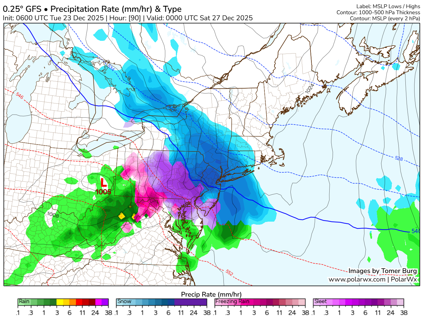
December 26-27th event has been a model guidance nightmare these past few days so that’s why i haven’t really talked much about it. Because at one moment its a 63 degree day with rain and then next minute its a day with accumulating snow and ice. This is very typical back and forth nonsense that happens in the 84-120hr timeframe so i don’t put a whole lot of weight to it. But we are starting to get into the sub 84 timeframe where they begin to get their act together. So here is the setup.
We will already have a push of arctic air in place out ahead of a weak disturbance with a warm front nosing into the cold air. This is a classic representation of what we call a “Overrunning Event”
An overrunning event in winter meteorology occurs when warm, moist air is lifted up and over a shallow layer of cold air at the surface. This setup is common ahead of winter storms and often develops north of a warm front. Because cold air is denser, it remains trapped near the ground while warmer air flows over it along sloping isentropic surfaces.
As the rising warm air cools, clouds and precipitation develop well in advance of the main storm system. In winter, this frequently leads to widespread, long-duration precipitation, often falling as snow, sleet, or freezing rain, depending on the temperature profile of the atmosphere. Overrunning events are typically associated with stratiform precipitation, lower visibility, and steady rather than convective rainfall or snowfall.
These events can produce significant winter weather impacts, including heavy snow accumulations, ice accretion, and hazardous travel conditions, especially when cold air is reinforced at the surface by high pressure to the north. Overrunning precipitation often marks the initial phase of a winter storm before stronger dynamics and surface low pressure move in.
With the latest mid day mid range guidance rolling in they are starting to come into light of a icing scenario beginning to unfold across areas of central and northern Delmarva, northern Maryland, and portions of South Jersey. A lot of factors remain in place like will the cold air remain more locked in and keep the warm nose at bay, will the warm nose make it a widespread icing event, or will the warm nose overwhelm the environment and keep it more of a rain threat in the region. Those are the details we need to iron out going later into the week.
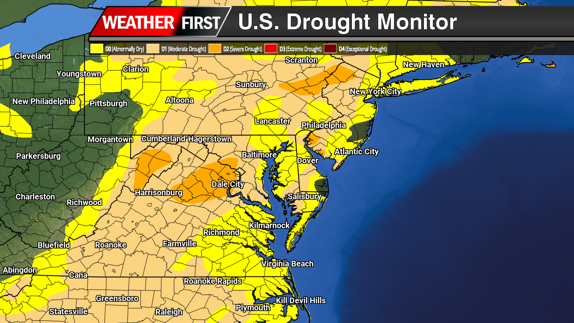
Dry weather has continued to dominate the Delmarva Peninsula, with the latest drought data showing little improvement and increasing stress across the region. While occasional light rainfall has been observed, precipitation totals remain well below normal, providing minimal benefit to soil moisture, groundwater, or streamflows.
Across Delaware, Maryland’s Eastern Shore, and Virginia’s Eastern Shore, ongoing precipitation deficits have allowed abnormally dry to drought conditions to persist and expand. Soils continue to dry, particularly in agricultural areas, and streamflows remain below seasonal averages; clear indicators that the region remains in a developing drought pattern.
In Delaware, short-term dryness is increasingly transitioning into longer-term impacts, with limited recharge of groundwater and growing concerns for water resources if the dry trend continues. On the Maryland Eastern Shore, reduced soil moisture is beginning to affect winter crop establishment and could pose challenges heading into the early spring growing season if meaningful rainfall does not return. Portions of the Virginia Eastern Shore are experiencing similar conditions, with continued low streamflows and dry soils reinforcing drought development.
Looking ahead, forecasters stress that several widespread, soaking rain events will be necessary to slow or reverse drought conditions across Delmarva. Until a wetter pattern develops, drought impacts are expected to persist through the remainder of the year, with close monitoring in place for further degradation.
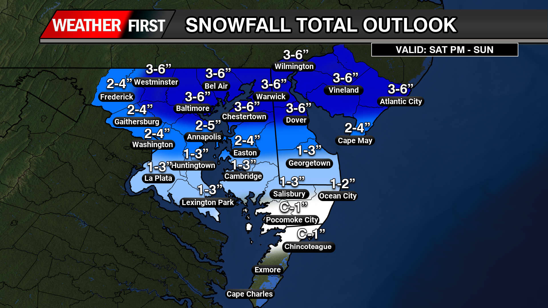
Another round of accumulating snowfall is on tap for this weekend during the early morning hours Sunday through the late morning hours. Overall snowfall amounts have increased across Central and Northern Delmarva for tonight. A Clipper system approaching from the Mid-west will begin to redevelop a coastal low will bring a band of light to moderate snowfall to the region on Sunday as an arctic frontal boundary moves through bring severely cold temperatures throughout the Eastern US.
Looks like right now areas across Northern Maryland, Northern Delmarva, and South Jersey will be in the hot seat for seeing the most accumulating snow when the coastal low begins to take over. A widespread swaft of 3-6 inches of snow is likely with areas further south will have lighter precipitation to deal with overall. Making for Sunday morning travel a bit slick with temperatures in the upper 20s to lower 30s and the winds begin to pick up later in the day for some blowing and drifting.
An Arctic air mass is moving southward, bringing dangerously low temperatures and life-threatening wind chills across a broad swath of the central US, from the Northern Plains towards the Mid-Atlantic
Temperatures are forecasted to plunge 20 to 30 degrees below normal, with wind chills dropping below -30°F in some areas. This extreme cold poses serious risks to human health, pets, and infrastructure, including the potential for frozen pipes.
Residents in the affected regions are urged to prepare immediately by taking steps to protect themselves, their animals, and their homes. The agencies emphasize the importance of readiness to mitigate the harsh impacts of this severe weather event.
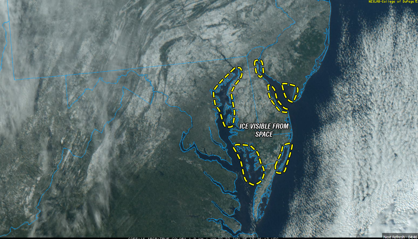
The U.S. Coast Guard has set Winter Port Condition One for the Chesapeake Bay and the Chesapeake & Delaware (C&D) Canal due to increasing ice formation in the region’s waterways. This status indicates that current weather conditions are conducive to further ice development.
Recent observations revealed up to 40% ice coverage, with thicknesses reaching two inches, in areas including the C&D Canal, Welch Point to Nine Foot Knoll, and Turkey Point. Further south, from Quantico to Alexandria, Va., as well as the D.C. Harbor and Anacostia River, ice coverage stands at approximately 30%, with thicknesses around one inch. The Nanticoke and Wicomico rivers report 15% ice coverage at one inch thick.
While no navigation restrictions are currently imposed, the Coast Guard advises mariners to exercise caution. Ice can displace buoys and damage navigational aids, potentially leading to hazards. If ice coverage approaches 100% and impacts port operations, the Coast Guard may initiate icebreaking efforts and implement vessel restrictions.
The Maryland Department of Natural Resources (DNR) and the Coast Guard have icebreaking vessels on standby. Recent icebreaking activities have been reported in sheltered areas, including Selby Bay, South River, and Bay Bridge Marina, to assist vessels hindered by ice accumulation. Continued low temperatures could lead to widespread ice in creeks and along river and bay shorelines, potentially affecting routes such as the Smith Island to Crisfield ferry and oyster harvest operations.
Emergency services are also preparing for icy conditions. The Hacks Point Fire Company conducted ice rescue training at Hack Point Marina on the Bohemia River over the weekend to ensure readiness for potential emergencies.
72-year-old Gloria Williams, of New Castle, DE – Delaware State Police
A 72-year-old New Castle woman was arrested on felony assault charges after police say she stabbed a person who tried to throw away her walker.
According to the Delaware State Police Department, the incident occurred around 9:30 p.m., Tuesday at the Hollywood Motel on South Dupont Highway in New Castle.
Police arrived and learned that a 57-year-old victim was engaged in a verbal argument with 72-year-old Gloria Williams over a suspected theft, according to police. The argument escalated and turned physical.
After the two were separated, police say a short time later the victim tried to throw Williams’ walker in the dumpster. During this action, Williams allegedly produced a knife and stabbed the victim in the upper extremity. The victim was treated at an area hospital with non-life-threatening injuries.
When police arrived, Williams reportedly still had the knife in her hand. The knife was recovered and she was taken into custody without incident.
Williams was charged with Possession of a Deadly Weapon During the Commission of a Felony (Felony) and Assault 2nd Degree (Felony). She was arraigned and committed to the Delores J. Baylor Correctional Institution on $30,000 secured bond.
The Delaware Department of Transportation (DelDOT) is under fire after countless people were sent false toll violations when they didn’t run the toll. DelDOT is refusing to acknowledge the issue as more people continue to speak out, demanding something be done to fix the issue.
TV Delmarva News has been inundated with interview requests from dozens of residents across the state who received toll violations after traveling through the Biddle’s Corner Toll Plaza in New Castle County when they had a working E-ZPass with active funds in their account.
The issue appears to span over the course of at least the past six months as reports of the false violations, for some residents, date all the way back to October, 2021. Some residents, including Sherry Steller, of Smyrna, have received dozens of false violations and are now speaking out, demanding DelDOT take action to resolve the issue.
“As of today, I have 17 more coming today,” Sherry said. “Once I add the 17 in today, I’ll be at 78 toll violations. I went down to E-ZPass in Dover, spent an hour in there and showed her all my transponders, she checked the batteries and everything is great, and then she tells me to write an appeal for every single violation that I got. My time is valuable to me, I don’t have time to sit around and do appeals when the fault is not my fault.”
TV Delmarva News Director & Reporter Rob Petree raised these concerns directly to DelDOT’s Community Relations Director, Charles McLeod, who refused to acknowledge the issue and repeatedly requested that everyone who raises theses concerns contact customer service. Our interview request was then denied.
Is Bodybuilding a Dysfunctional Vanity Sport? clomid vs nolvadex for pct lines drawn | bodybuilding steroids banned, buy testosterone cypionate online with credit card
“We encourage them to contact customer service,” McLeod stated in an email response. “We will be glad to investigate the issue with the individuals but won’t be providing any interviews at this time.”
Everyone we have interviewed and spoke to who has been impacted by this issue has already reached out to DelDOT customer service to no avail, some of whom have already had their false toll violations sent to collections, including Adam Pritchett, of Camden, who said DelDOT did nothing to resolve the issue, all the while knowing that it wasn’t his fault but rather an error on their end, and still nothing was done.
“It’s been a long stream of this,” Pritchett said. “They told me it was my transponder, so I invested in four new transponders for my vehicles, and then I’d go through there and it would say ‘good to go’ every time, and then I would get notices in the mail that I had ran through the violation and it would show a picture of my tag. And I’m like ‘why are they sending me notices’ I’m an E-ZPass account holder, it should be real simple. It’s happen multiple times and I’ve even been taken to collections because I can’t even resolve the issue when I call customer service.”
Chris Phipps, of Smyrna, said he went above and beyond to get the issue resolved with DelDOT after he received a toll violation when he knew for a fact he had funds in his E-ZPass and that it wasn’t his fault. He has not heard back after he appealed the decision and is speaking out to call for a resolution to this issue that has affected countless Delawareans.
“I’m very frustrated, very angry, and I would hope if anything just a little transparency, a simple letter in the mail to say they received it, an email, or anything,” Phipps said. “Their online portal, in my opinion, is a joke. I don’t know how it takes two weeks to get a letter back. I don’t understand how it’s like this, it’s very old, but I’m just trying to get by as much as I can I guess.”
The extent of the issue, exactly how many people have been affected and what’s causing this to happen, all of which DelDOT has refused to acknowledge, is not yet known at this time. What is clear however is that the issue is affecting residents from all corners of the state, including Jeff and Barbara Baskin, of Lewes, who also received a toll violation from the Biddle’s toll plaza when they shouldn’t have.
“We discovered it when we got the letter in the mail saying we went through a toll booth and that we did not have a transponder, which is not true, we had one,” Jeff Baskin explained. “It’s more like it didn’t read it or something in my mind, but then I’m looking at it again, and on there, just eyeing the tolls because I’ve been running up to Pennsylvania regularly now, my Mom is ill and it’s a lot, and I looked down and for some reason it has us as a different class of vehicle at the same toll booth. Again, I’m going up to Pennsylvania and back, so I go through four toll booths, and the other three show me as a Class 2 and all of a sudden this one’s Class 4 and it’s like ‘what’s going on?’”
Kelsey Gallagher, of Smyrna, said she recently got a large stack of false toll violations, all with random dates, showing her tag. For each one of them, she says she had a working, funded, E-ZPass transponder in her vehicle and should not have received the violations.
“I tried to go online and enter them to put my transponder in, and it won’t even let me do that, it says ‘call the main office’,” Kelsey said. “I’m really frustrated with this. It’s just maddening, I’m a full-time working Mom, I’m just busy all the time, and I shouldn’t have to take so much time out of my day to try and call them and wait on hold forever, and then just try and get ahold of somebody, when I’ve had it in my window this whole time, why is it not being used the way it’s supposed to be used?”
Countless people from across the state have flooded our social media with reports of the same thing happening to them, receiving a toll violation when they didn’t violate the toll, and then having to run around in circles with DelDOT to resolve the issue that wasn’t their fault to begin with:
“About a month ago I got 13 toll violations,” one user wrote. “This week 5 more smh dated as far back as October 2021 to January 2022.”
“They sent me the violation letter and I checked my E-Z Pass account to find that I had already paid the toll with my E-Z Pass,” another user wrote on our Facebook page. “They were trying to charge me $51.00 for a $1.00 toll that had been paid. Glad I checked and called them today!”
“It’s another scam the state has to gain revenue if you don’t pay it any attention,” one user speculated.
“We have a stack of them from as far back as August 2021,” another user wrote. “We get them in groups of 3-8 every few days. All appeals have been denied, although we have active EZ Pass.”
“My husband and I had some violations as high as $4,000,” another user wrote online. “We have transponders in both of our vehicles.”
Sure do have a whole stack,” yet another user wrote. “I have an active E-ZPass account and a transponder in each vehicle. Was told perhaps it was my tinted windshield so I traded the car in…still happening with my new vehicle with no tint on windshield.”
For a $1 toll on Route 1, the cost of violating it is upwards of $50 in fines. Many people who’ve been billed have been unable to resolve the issue with DelDOT, who at this time is refusing to acknowledge the it and continues to direct everyone to contact customer service. An interview request with DelDOT Secretary Nicole Majeski was denied.
TV Delmarva News is continuing to investigate this developing story. We will continue to bring you stories of Delawareans impacted by this issue until DelDOT addresses it and resolves the problem.
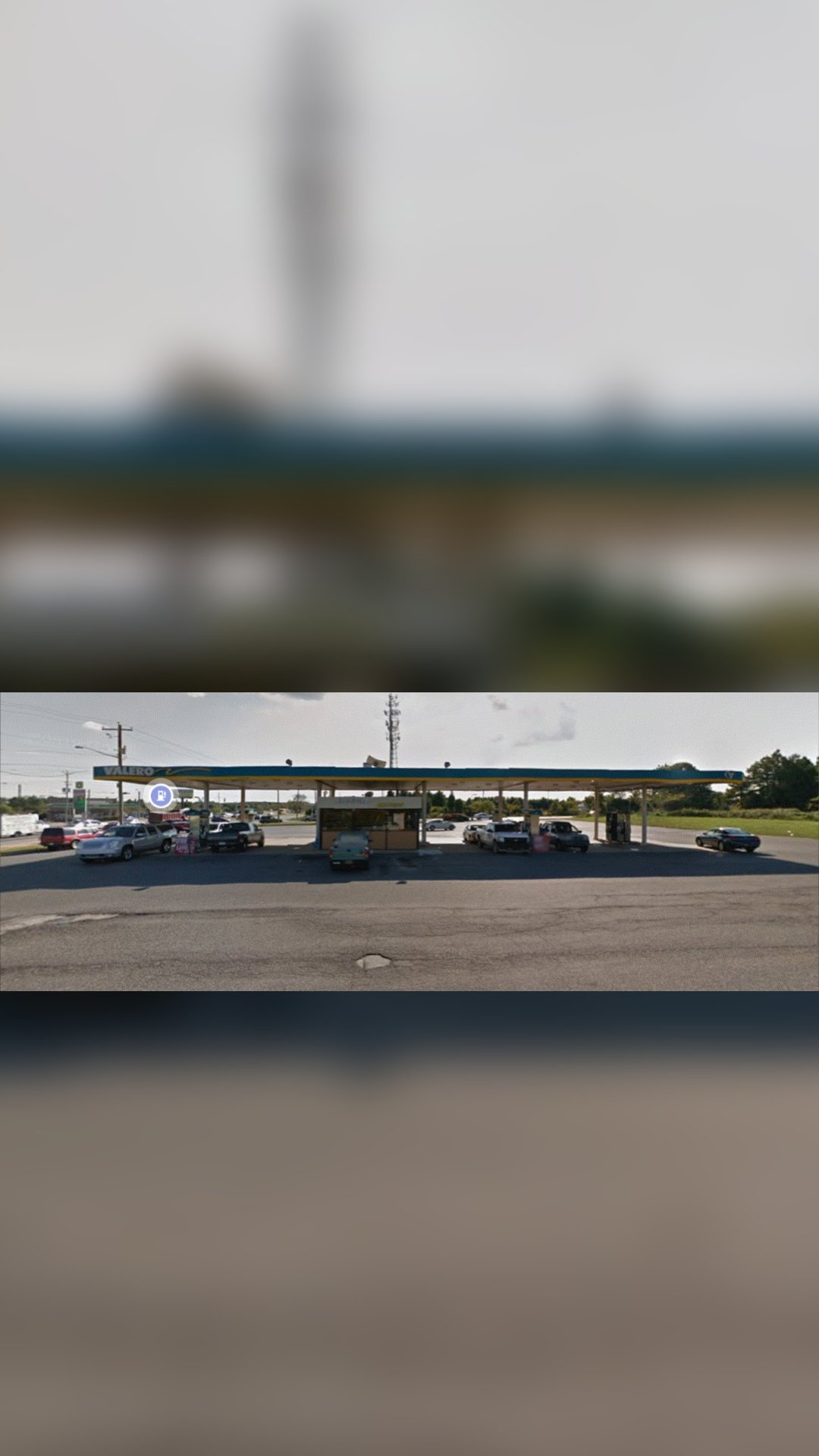
Delaware State Police are investigating a shooting incident that occurred outside a New Castle gas station Thursday afternoon.
On March 24, 2022, at approximately 1:00 p.m., a 33-year-old Smyrna man arrived at Valero located at 891 S. Dupont Highway, New Castle, to get fuel. He pulled his vehicle into the diesel pump before realizing he was at the wrong pump. He reversed his car to another gas pump when a black male standing outside of a passenger vehicle parked at a nearby gas pump fired multiple rounds at the victim as he was still reversing. The victim immediately placed his car in drive, fled the area, and drove to a nearby hospital. The victim was struck multiple times and was treated for non-life-threatening injuries.
After the shooting, the unknown suspect fled the area northbound onto Bear Road. There is currently no suspect information or surveillance footage available.
Delaware State Police Troop 2 Criminal Investigation Unit is currently investigating this incident. Anyone who witnessed or has information regarding this incident is asked to contact Det. Amy Bange by calling 302-365-8411. Information may also be provided by sending a Private Facebook Message to the Delaware State Police or contacting Delaware Crime Stoppers at 1-800-TIP-3333 or via the internet at www.delawarecrimestoppers.com
52-year-old Catherine Dorczuk, of New Castle, DE – Harrington PD
A New Castle woman was arrested for her third DUI offense in Harrington.
According to the Harrington Police Department, shortly before 11 p.m., Tuesday officers patrolling South DuPont Highway stopped a vehicle for a traffic violation.
Officers then made contact with the driver, identified as 52-year-old Catherine Dorczuk, at which time an odor of alcohol was smelled coming from the vehicle along with alcohol bottles that were in plain view inside the car.
Police administered a standardized field sobriety test and Dorczuk was taken into custody.
A vehicle search was conducted and police located drug paraphernalia inside the vehicle.
Dorczuk was transported to the Harrington Police Department for processing. A computer check revealed she had two previous DUI convictions dating back to 1995. She was arraigned at Justice of the Peace Court 7 and was charged with 3rd Offense Driving under the Influence of Alcohol (Felony), Possession of Drug Paraphernalia and Speeding. She was then committed to the Sussex Correctional Institute in default of $3,501 cash only bond.