Tag: kent

  • Rain Threat Increases Across the Mid Atlantic Through the Weekend

    Rain Threat Increases Across the Mid Atlantic Through the Weekend

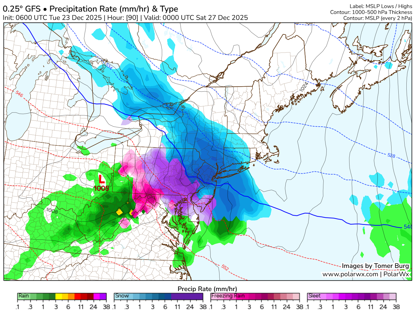
    A prolonged period of unsettled weather is expected to impact much of the Mid Atlantic beginning later this evening and continuing through Sunday, bringing multiple rounds of rain and the potential for localized flooding concerns.

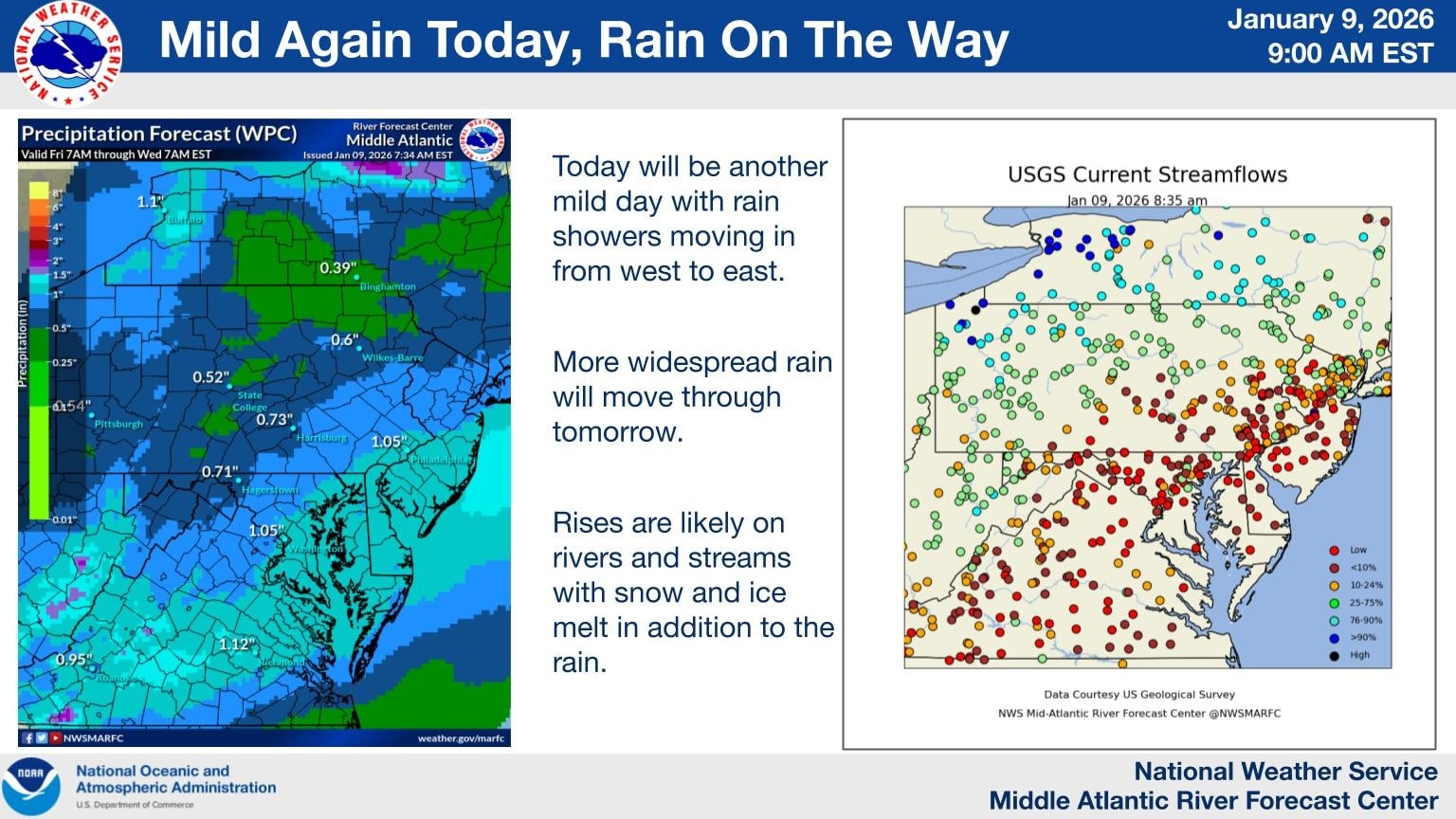
    Rain showers will begin moving into the region from west to east this evening as a mild and moisture rich weather pattern remains in place. While rainfall tonight is expected to be generally light to moderate, coverage will increase overnight and into Saturday as a stronger system approaches.

    More widespread rain is forecast for Saturday and Saturday night as deeper moisture moves into the Mid Atlantic. Periods of steady rain are likely, with occasional heavier downpours. Embedded isolated thunderstorms are also possible during this time, which could briefly enhance rainfall rates in some areas.

    By Sunday, additional rounds of showers are expected to continue, keeping soils saturated and rivers on the rise. While rainfall amounts will vary by location, several areas could see one to two inches of rain by the end of the weekend, with locally higher totals where heavier showers or thunderstorms occur.

    Delmarva Region Faces Elevated Rain And Water Concerns

    Across the Delmarva Peninsula, including Delaware, eastern Maryland, and the Eastern Shore of Virginia, the rain threat will become more pronounced overnight and persist through the weekend. Rainfall totals of one to two inches are likely across much of the region, with isolated higher amounts possible.

    The combination of steady rain, mild temperatures, and ongoing snow and ice melt farther north could lead to noticeable rises on rivers, streams, and creeks. Low lying and poor drainage areas may be especially susceptible to ponding of water, particularly during periods of heavier rain.

    While widespread flooding is not currently expected, localized minor flooding cannot be ruled out, especially if thunderstorms produce brief heavy downpours. Urban areas and locations near small waterways should remain alert for changing conditions.

  • SNEAKY ICING EVENT ON BOXING DAY DEC 26-27TH?

    SNEAKY ICING EVENT ON BOXING DAY DEC 26-27TH?

    December 26-27th event has been a model guidance nightmare these past few days so that’s why i haven’t really talked much about it. Because at one moment its a 63 degree day with rain and then next minute its a day with accumulating snow and ice. This is very typical back and forth nonsense that happens in the 84-120hr timeframe so i don’t put a whole lot of weight to it. But we are starting to get into the sub 84 timeframe where they begin to get their act together. So here is the setup.

    We will already have a push of arctic air in place out ahead of a weak disturbance with a warm front nosing into the cold air. This is a classic representation of what we call a “Overrunning Event”

    An overrunning event in winter meteorology occurs when warm, moist air is lifted up and over a shallow layer of cold air at the surface. This setup is common ahead of winter storms and often develops north of a warm front. Because cold air is denser, it remains trapped near the ground while warmer air flows over it along sloping isentropic surfaces.

    As the rising warm air cools, clouds and precipitation develop well in advance of the main storm system. In winter, this frequently leads to widespread, long-duration precipitation, often falling as snow, sleet, or freezing rain, depending on the temperature profile of the atmosphere. Overrunning events are typically associated with stratiform precipitation, lower visibility, and steady rather than convective rainfall or snowfall.

    These events can produce significant winter weather impacts, including heavy snow accumulations, ice accretion, and hazardous travel conditions, especially when cold air is reinforced at the surface by high pressure to the north. Overrunning precipitation often marks the initial phase of a winter storm before stronger dynamics and surface low pressure move in.

    With the latest mid day mid range guidance rolling in they are starting to come into light of a icing scenario beginning to unfold across areas of central and northern Delmarva, northern Maryland, and portions of South Jersey. A lot of factors remain in place like will the cold air remain more locked in and keep the warm nose at bay, will the warm nose make it a widespread icing event, or will the warm nose overwhelm the environment and keep it more of a rain threat in the region. Those are the details we need to iron out going later into the week.

  • Drought Conditions Continue to Worsen Across Delmarva

    Drought Conditions Continue to Worsen Across Delmarva

    Dry weather has continued to dominate the Delmarva Peninsula, with the latest drought data showing little improvement and increasing stress across the region. While occasional light rainfall has been observed, precipitation totals remain well below normal, providing minimal benefit to soil moisture, groundwater, or streamflows.

    Across Delaware, Maryland’s Eastern Shore, and Virginia’s Eastern Shore, ongoing precipitation deficits have allowed abnormally dry to drought conditions to persist and expand. Soils continue to dry, particularly in agricultural areas, and streamflows remain below seasonal averages; clear indicators that the region remains in a developing drought pattern.

    In Delaware, short-term dryness is increasingly transitioning into longer-term impacts, with limited recharge of groundwater and growing concerns for water resources if the dry trend continues. On the Maryland Eastern Shore, reduced soil moisture is beginning to affect winter crop establishment and could pose challenges heading into the early spring growing season if meaningful rainfall does not return. Portions of the Virginia Eastern Shore are experiencing similar conditions, with continued low streamflows and dry soils reinforcing drought development.

    Looking ahead, forecasters stress that several widespread, soaking rain events will be necessary to slow or reverse drought conditions across Delmarva. Until a wetter pattern develops, drought impacts are expected to persist through the remainder of the year, with close monitoring in place for further degradation.

  • Largest Ice Build Up In Several Years For Delmarva Coastal Waters

    Largest Ice Build Up In Several Years For Delmarva Coastal Waters

    The U.S. Coast Guard has set Winter Port Condition One for the Chesapeake Bay and the Chesapeake & Delaware (C&D) Canal due to increasing ice formation in the region’s waterways. This status indicates that current weather conditions are conducive to further ice development.

    Recent observations revealed up to 40% ice coverage, with thicknesses reaching two inches, in areas including the C&D Canal, Welch Point to Nine Foot Knoll, and Turkey Point. Further south, from Quantico to Alexandria, Va., as well as the D.C. Harbor and Anacostia River, ice coverage stands at approximately 30%, with thicknesses around one inch. The Nanticoke and Wicomico rivers report 15% ice coverage at one inch thick.

    While no navigation restrictions are currently imposed, the Coast Guard advises mariners to exercise caution. Ice can displace buoys and damage navigational aids, potentially leading to hazards. If ice coverage approaches 100% and impacts port operations, the Coast Guard may initiate icebreaking efforts and implement vessel restrictions.

    The Maryland Department of Natural Resources (DNR) and the Coast Guard have icebreaking vessels on standby. Recent icebreaking activities have been reported in sheltered areas, including Selby Bay, South River, and Bay Bridge Marina, to assist vessels hindered by ice accumulation. Continued low temperatures could lead to widespread ice in creeks and along river and bay shorelines, potentially affecting routes such as the Smith Island to Crisfield ferry and oyster harvest operations.

    Emergency services are also preparing for icy conditions. The Hacks Point Fire Company conducted ice rescue training at Hack Point Marina on the Bohemia River over the weekend to ensure readiness for potential emergencies.