Tag: impacts

  • 30 Years Later: Reflecting on the Blizzard of ’96 and the Impact on Delmarva

    30 Years Later: Reflecting on the Blizzard of ’96 and the Impact on Delmarva

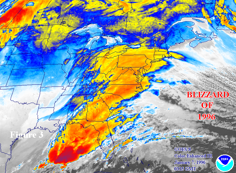
    This winter marks 30 years since one of the most powerful and memorable winter storms in Mid-Atlantic history — the Blizzard of 1996. From January 6 through January 8, a classic nor’easter buried much of the Eastern United States under a historic blanket of snow, bringing life to a standstill from Virginia all the way to southern New England. Thirty years later, the effects of that storm remain part of the weather lore of communities across the Delmarva Peninsula.

    A Storm that Shut Down the Region

    The Blizzard of ’96 was not simply a big snowstorm, it was a paralyzing meteorological event. Fueled by abundant Gulf moisture lifting into frigid Arctic air, the storm produced heavy snowfall, fierce winds, and drifts as high as 5 to 8 feet in places, and it cut off normal travel and commerce for days. More than 20 inches of snow was common from the Smoky Mountains to the Northeast, with Baltimore alone recording more than 22 inches.

    Across the broader Mid-Atlantic, most major airports closed, highways like Interstate 95 became impassable, government and business operations shut down, and utility outages were widespread as heavy snow and strong winds downed trees and power lines.

    Delmarva’s Experience: Snow, School Closures, and Water Issues

    Although Delmarva lies on the more southern and coastal edge of the storm’s heaviest snow, many parts of the Eastern Shore still saw significant impacts. In Delaware and Maryland’s eastern counties, reports from regional accounts show that snowfall totals often reached into the teens across Delmarva, with southern and interior areas picking up even more as the storm slowly moved northward.

    Across the peninsula, schools and local governments closed for days, giving many children extended breaks and making the blizzard one of the most memorable weather events of a generation for families on the Eastern Shore. Many locals from surrounding Mid-Atlantic communities still reminisce about “the week the snow didn’t stop” and the long task of digging out afterward.

    After the Snow: Rapid Melt and Flooding

    What made the Blizzard of 1996 especially notable wasn’t just the snowfall — it was what happened after the snow stopped. Warm and humid air rapidly moved in shortly after the storm, bringing heavy rain and quick snowmelt across the Mid-Atlantic. This combination caused major flooding in rivers and streams throughout the region, including Chesapeake Bay tributaries that affect Delmarva’s watersheds.

    Tributaries that feed into the Bay saw record flows as hundreds of millions of gallons of water — along with nutrients and sediment from the melting snowpack — rushed downstream, raising water levels and flooding low-lying farmland around Delmarva rivers and streams.

    Long-Term Memories and Local Culture

    In the decades since, the Blizzard of ’96 has remained a touchpoint in local weather memory. Many families on Delmarva still tell stories of being snowed in for days, navigating icy roads, building massive drifts and snow forts, and enduring extended school closures that are still talked about at community gatherings.

    For long-time residents of the Mid-Atlantic and Delmarva, the storm also stands as a reminder of how quickly winter weather can transition from snow to serious flooding, the importance of emergency preparation for both snow and water events, and how a single storm system can reshape community life for weeks.

  • Significant Winter Storm Ahead For Delmarva Sunday Night Through Tuesday.

    Significant Winter Storm Ahead For Delmarva Sunday Night Through Tuesday.

    Signs continue to push for a significant winter storm on the way from areas of the central Plains towards the Mid-Atlantic states over the next few days with heavy snow and dangerous ice. A few changes in the overall forecast are now in play of a colder and slight shift south in the overall snow axis. Let’s go through the run down once more.

    During the daytime hours on Sunday will we be looking at a sunny but very chilly day with highs struggling to get above freezing before later that night clouds start to increase and the snow moves in. Everyone across the region will start off as snow with temperatures in the 20s. Snow ratios will be up slightly during this time period upwards to 15:1. A more powdery & dry snow as temperatures slowly start to warm into the daytime hours on Monday. From the latest futurecast thus far showing widespread areas of moderate snow in time for the Monday morning rush hour and continue throughout the daytime hours. Trends been showing the cold air locking in place a bit better with the extent of the snow shifting south.

    With the American models the GFS/NAM have trended even more south and a little bit colder overall throughout the event but still promoting the warmest solutions of them all. Mixing once again still remaining a possibility towards areas near Salisbury on southward. Significant snowfall accumulations of snow across Central Delmarva. Also some dangerous ice further south in the battle ground zone to shake things up a bit with sleet and freezing rain. These solution have been trending towards the UKMET and ECMWF runs now from the past couple of days.

    UKMET and the ECMWF have been the most aggressive, colder, and even farthest south solutions out of the bunch over the last several days. Also have been the most persistent with the overall snow axis throughout the last several days. Bringing the most significant amounts from areas of the Kent Sussex line through areas near Fruitland, MD. But also as of this afternoon down to Pocomoke City. But i am worry about mixing of ice down in these areas as well so will be holding them a bit lower in amounts as of now.

    As it stands, we are expected widespread amounts of 6-12 inches throughout much of Central and Northern Delmarva with the potential of a localized heavier band to setup during the day on Monday. Mixing is possible for areas further south of Salisbury to reduce totals down a bit. Regardless, a major winter storm is on the way for the first time in 3 years across the region. Make plans and prepare for snow covered roadways and hazardous road conditions. More updates to follow ahead.

  • Hurricane Milton Aiming For The West Coast Florida Next Week

    Hurricane Milton Aiming For The West Coast Florida Next Week

    The west coast of Florida is bracing for the potential landfall of Hurricane Milton, a rapidly intensifying storm expected to impact the Tampa Bay region and surrounding areas. With projections showing the storm strengthening significantly over the next few days, Florida residents are preparing for what could be another major hurricane following the devastation caused by Hurricane Helene.

    Rapid Intensification Expected

    Forecasters warn that Hurricane Milton is set to undergo rapid intensification, potentially reaching Category 3 or higher before making landfall. Warm Gulf waters and favorable atmospheric conditions are contributing to the storm’s swift development, raising concerns for communities along the west coast of Florida.

    The National Hurricane Center has advised residents in the projected path of Milton to begin preparations now, as the storm may bring life-threatening storm surges, heavy rainfall, and damaging winds. Evacuation orders could be issued in the coming days as the storm’s path becomes clearer.

    Tampa Bay Region at Risk

    The Tampa Bay region, including major cities like Tampa, St. Petersburg, and Clearwater, is under the gun for a potential direct hit from Milton. This area, vulnerable to storm surges due to its coastal geography, faces significant risks if the hurricane continues on its current trajectory.

    Emergency services and local governments are urging residents to secure their properties and gather essential supplies in anticipation of power outages, flooding, and disruptions to daily life.

    Florida Braces for Another Major Impact

    If Hurricane Milton makes landfall as a major hurricane, it will mark Florida’s constant strike for Major Hurricanes here in the last several years in a row. The scars from Helene are still fresh for many, and Milton’s approach has heightened anxiety across the state. However, state and local officials are mobilizing resources and preparing emergency response plans to ensure a coordinated effort to protect lives and property.