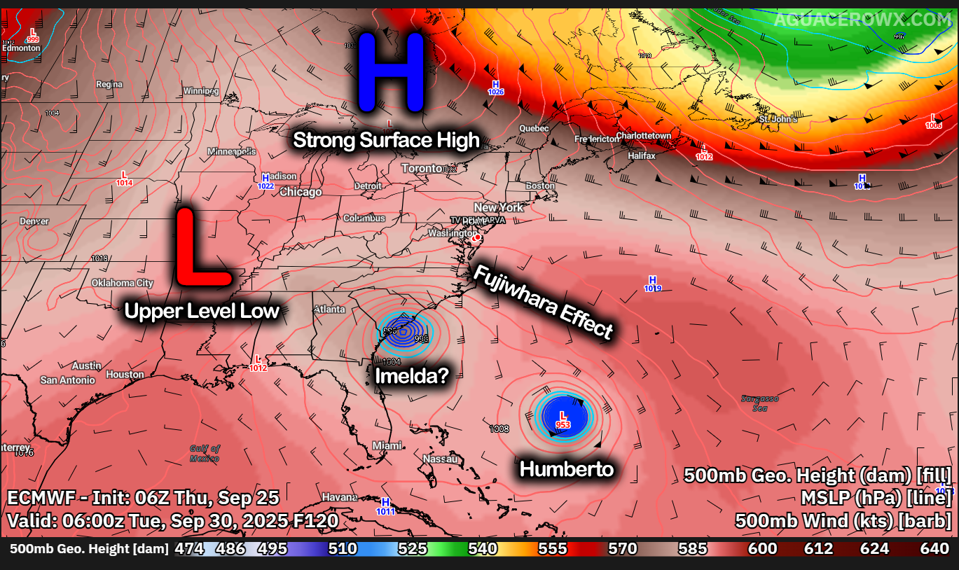
Ladies and gentlemen, we may get to witness an extremely unique weather phenomena coming into early next week. There has been a lot of talk about something called the “Fujiwhara Effect” and this is becoming more of a real scenario which makes forecasting very difficult. We already have Humberto which formed yesterday in areas north and east of the Lesser Antilles which is expected to become a major hurricane towards the weekend. Another tropical wave near Hispaniola is expected to develop into Imelda and will become in close enough proximity to Humberto to do a bit of a waltz we can say.
First off what is the Fujiwhara Effect? The Fujiwhara effect describes the rotational interaction of two vortices, such as tropical cyclones, where they orbit a common center and can either merge into one larger storm, cause one to be absorbed, or break apart and move away from each other. The effect, named after Japanese meteorologist Sakuhei Fujiwhara, is more common in the Pacific Ocean, where tropical cyclones are more numerous.
This is exactly what we have going on here with potentially two tropical cyclones is close enough proximity to start doing some very strange movements as they share a similar fulcrum point between each other. Humberto should stay off our coast but Imelda is the one to watch as this becomes a threat towards the Southeast US coastal toward the Mid-Atlantic coasts. To throw a bigger wrench into things, we have a strong surface high moving in across the Great Lakes and New England with a retrograding upper level low in the Midwest. So many steering currents to bring what would be Imelda towards the US Coastlines. And could stall Imelda in place with a tremendous rainfall threat.
We really need to see if Imelda can form a center of circulation to get a better handle on where it would go and the impacts with the Fujiwhara. This is going to be a fairly impactful and intriguing setup overall. The meteorology behind this is truly astonishing. Regardless, residents along the Eastern Seaboard need to relate alert as we head into the weekend.
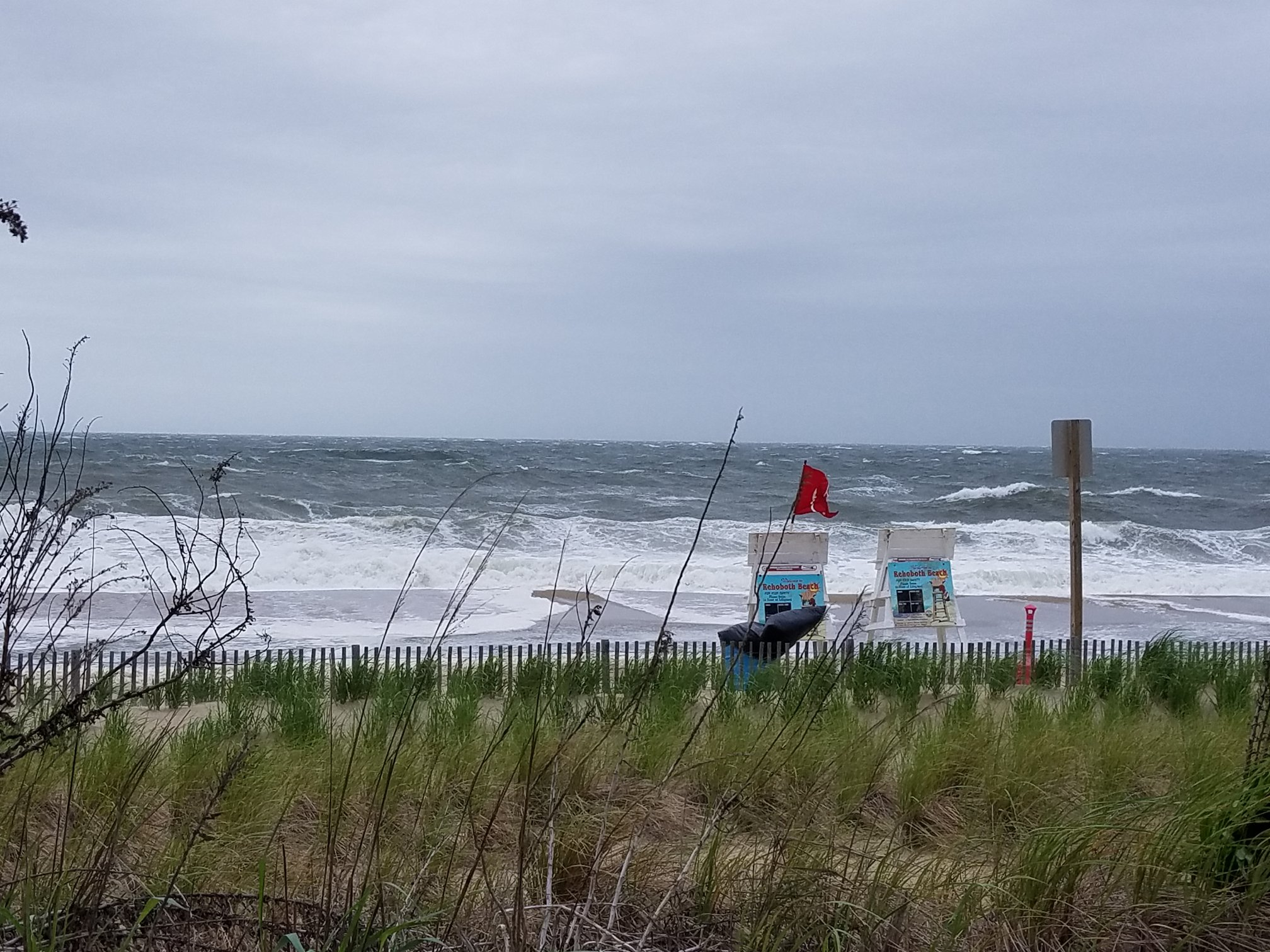
— Hurricane Erin is currently off the coast of the Delmarva Pennisula. Beaches along the Eastern Seaboard have raised red flags, warning the public about dangerous surf and rip currents. Public officials, meteorologists, and emergency responders have all strongly advised against entering the water or engaging in beach recreation during this time. Despite this, too many people ignore these warnings. They dismiss the threat by comparing the storm to past hurricanes or by calling official alerts “fake news.” This attitude is not just reckless; it endangers lives. Public weather alerts are issued for one fundamental reason: to save lives and protect communities. These warnings are based on complex meteorological data, satellite tracking, and sophisticated computer forecasting models that take into account storms’ wind speeds, rainfall potential, storm surge, and other hazards. They reflect expert analysis designed to help residents prepare for events that could cause flooding, property damage, injury, or loss of life. The forecasts are never perfect, but they are the single best guide available for decision-making during severe weather. The Delmarva Peninsula is especially vulnerable to the effects of hurricanes and tropical storms. Its low-lying geography makes it prone to flooding and storm surge.
History confirms the risks. In 2003, Hurricane Isabel caused major flooding on Maryland’s Eastern Shore. Many residents underestimated the danger, leading to costly damages and some fatalities. These events are reminders that storms can rapidly shift in intensity and impact, and no storm can be judged solely by the name or category it carries. Rip currents provide another deadly danger lurking near coastal waters. Even when skies seem clear, distant hurricanes create powerful currents that sweep swimmers away. Each year, lifeguards on Delmarva rescue dozens of people caught in rip currents, and fatalities occur when warnings are ignored. These dangers are not theoretical. Emergency responders put their lives at risk when they respond to people who disregard official advice. Ignoring safety warnings during high surf does not just risk one person’s life; it endangers entire communities and stretches local emergency resources. Social media complicates matters further. While it enables rapid sharing of information, it can also spread false or misleading messages.
Photo: James Spann
Posts claiming that storms are “no big deal” or that warnings are exaggerated encourage complacency. This undermines trust in professional meteorologists and emergency officials who spend countless hours ensuring their forecasts are as accurate as possible. Public confidence is essential in emergency management, and misinformation erodes that trust. People often compare new storms to past events, assuming they can “handle it better” or that it “won’t be as bad.” This oversimplifies the complex nature of severe weather. No two storms are exactly alike. Factors like storm speed, rainfall distribution, and coastal geography combine in unique ways each time, making every event different. Dismissing warnings by relying on past experience is dangerous. Sometimes, storms do weaken or shift course, leading some to say the forecasts were wrong. That perception fails to acknowledge the purpose of advance warnings: to give people time to take precautions against worst-case scenarios. It is better to prepare and have a storm pass with minor impacts than to ignore warnings and face disaster unprepared. In summary, public weather alerts exist to protect every member of the community.
They are developed through rigorous science and decades of storm data. When officials issue beach closures, evacuation orders, or high surf warnings, they do so with public safety as their priority. Ignoring these alerts is not a harmless act of skepticism; it endangers lives, burdens first responders, and threatens entire communities. The best way to protect yourself and those around you is to listen to professional forecasts, respect warnings, and prepare accordingly. Share accurate information and encourage others to do the same. Storms do not negotiate with opinions or social media posts. They follow the rules of nature. Our safety depends on understanding that truth and acting on it.
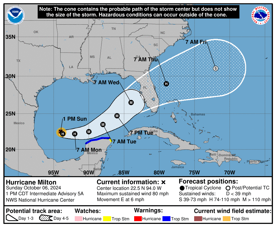
The west coast of Florida is bracing for the potential landfall of Hurricane Milton, a rapidly intensifying storm expected to impact the Tampa Bay region and surrounding areas. With projections showing the storm strengthening significantly over the next few days, Florida residents are preparing for what could be another major hurricane following the devastation caused by Hurricane Helene.
Rapid Intensification Expected
Forecasters warn that Hurricane Milton is set to undergo rapid intensification, potentially reaching Category 3 or higher before making landfall. Warm Gulf waters and favorable atmospheric conditions are contributing to the storm’s swift development, raising concerns for communities along the west coast of Florida.
The National Hurricane Center has advised residents in the projected path of Milton to begin preparations now, as the storm may bring life-threatening storm surges, heavy rainfall, and damaging winds. Evacuation orders could be issued in the coming days as the storm’s path becomes clearer.
Tampa Bay Region at Risk
The Tampa Bay region, including major cities like Tampa, St. Petersburg, and Clearwater, is under the gun for a potential direct hit from Milton. This area, vulnerable to storm surges due to its coastal geography, faces significant risks if the hurricane continues on its current trajectory.
Emergency services and local governments are urging residents to secure their properties and gather essential supplies in anticipation of power outages, flooding, and disruptions to daily life.
Florida Braces for Another Major Impact
If Hurricane Milton makes landfall as a major hurricane, it will mark Florida’s constant strike for Major Hurricanes here in the last several years in a row. The scars from Helene are still fresh for many, and Milton’s approach has heightened anxiety across the state. However, state and local officials are mobilizing resources and preparing emergency response plans to ensure a coordinated effort to protect lives and property.
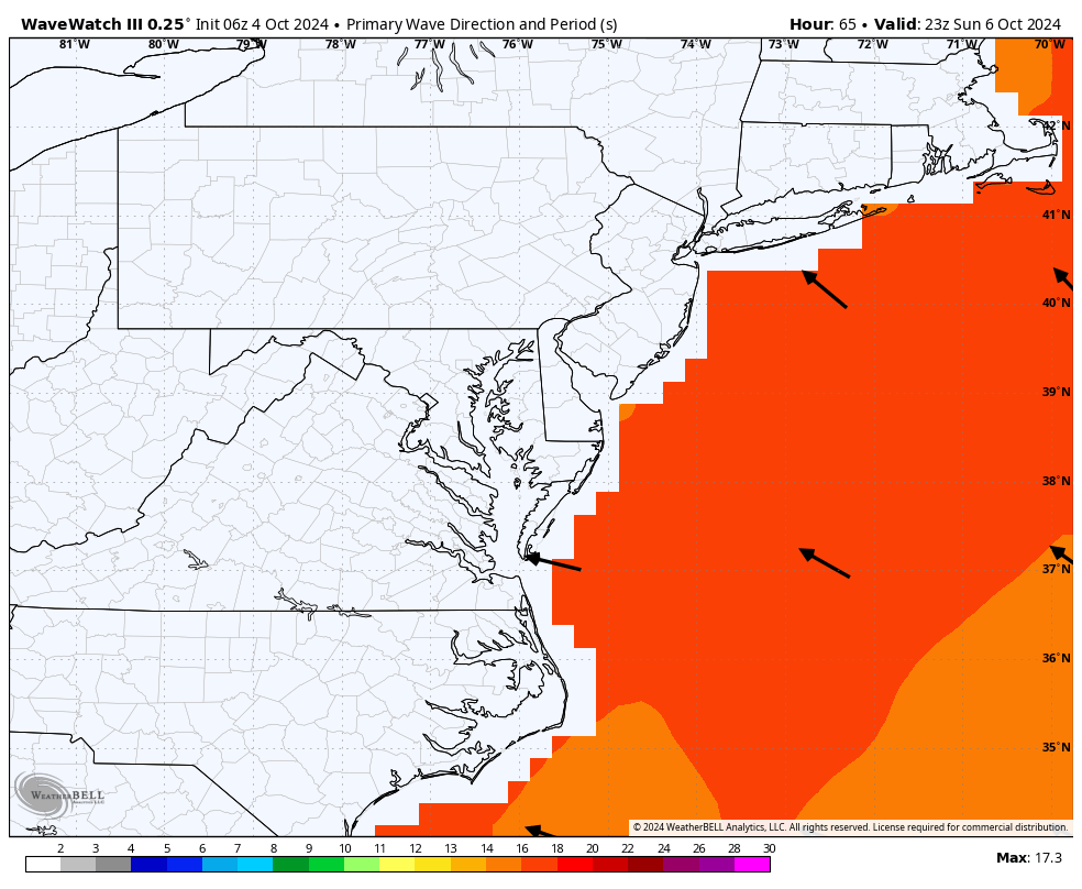
Starting this Sunday, the East Coast, particularly the Delmarva region, will see increased wave activity as long-period swells from Major Hurricane Kirk arrive. Currently a powerful Category 4 storm, Kirk is churning in the central Atlantic, far from land. However, the hurricane’s strength is generating significant wave action that will reach coastal areas, with wave heights projected between 4 to 8 feet.
These swells will bring more than just impressive waves. The combination of increased wave energy and prolonged exposure could result in some coastal erosion and minor flooding in vulnerable areas. The Delmarva coastline, known for its low-lying beaches, is particularly at risk. In addition, the elevated wave activity will heighten the risk of rip currents, making it dangerous for swimmers and beachgoers.
While Kirk itself poses no direct threat to land, as it is expected to curve safely toward the north and east, its indirect impacts will still be felt. The National Weather Service has advised those along the coast to remain vigilant, especially for rip currents, which can easily catch even experienced swimmers off guard.
Coastal communities are encouraged to prepare for potential minor flooding and erosion in sensitive areas as wave action intensifies through the weekend and into early next week.
Beachgoers and surfers should also be aware of local warnings and avoid swimming in areas where rip currents are likely.
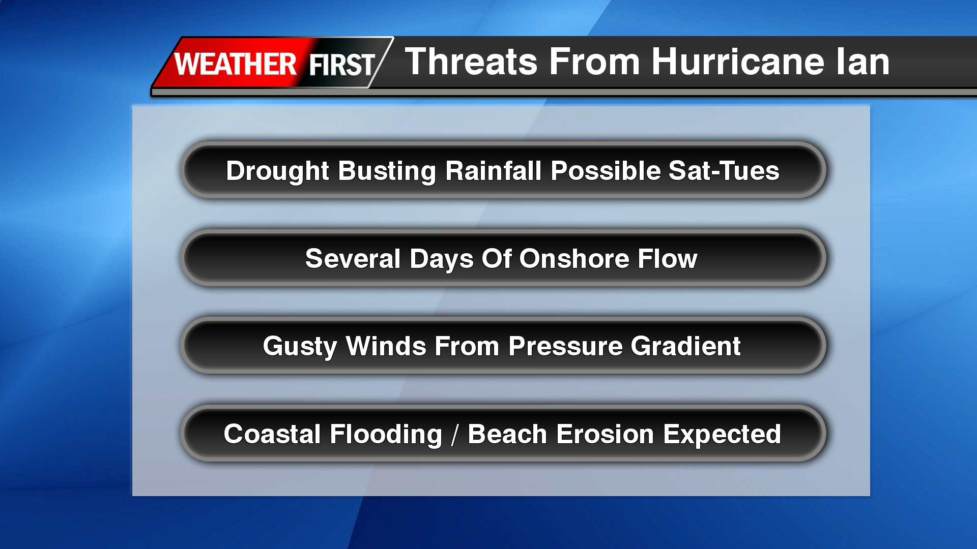
Well ladies and gentlemen, looks like we finally got our drought busting storm on the table for this upcoming weekend. Dangerous Major Hurricane Ian just passed over Cuba and was completely unphased and it’s full steam ahead toward the west coast of Florida. Ian is expected to make landfall somewhere along the Florida coast as a major hurricane and continue to move towards the northeast. Beyond that point is where things get very cruical.
Forecast Tracks Means Everything Regarding Impacts
Over the last 12 hours, forecast guidance has been taking Ian a bit further east away from the Panhandle of Florida. Even south of Tampa Bay where that has been the biggest threat in the past day or two. Now barreling in through Central Florida. Beyond that is where things get very complicated in the track.
NHC Future Track For Hurricane Ian
The reason Ian has had a big shift east is because of a large trough over Eastern Canada driving the atmospheric flow further east. But that wont last long. A strong surface high is going to be replacing the trough across the Great Lakes and Northeast USA. This tells Ian, oh no you are not going anywhere and bring the hurricane back towards the northwest due to the blocking high. The real question comes in too, does this go off the coast of Florida enough to gain a little bit of steam before rotating back into the Carolina’s? Very possible. Regardless the storms center will struggle to advance north past the Mid-Atlantic states. So the only place it can go is off our coast! Just like a nor’easter!
Impacts For Delmarva As Of Now
Impacts of Ian should be moving into the area beginning late Friday into Saturday morning with onshore flow and the rain bands. Although winds will be steady from the east, each high tide should be watched since this has the potential for being a long duration event especially for our coastal locations. Seas will be building as the pressure gradient begins to tighten up from the remnants of Ian slamming into the high pressure to the north.
The biggest issue I’m seeing right now is the amount of rain we could be seeing. We have multiple areas of moderate and severe drought here on Delmarva. With some of the model guidance and the latest from the WPC (Weather Prediction Center), we could be looking at some decent rainfall amounts. WPC being very bullish with areas of 5-10 inches over the course of the next several days. GFS/ECMWF showing a range of 4-7 inches by Tuesday. Which would be enough for inland flooding concerns.
Winds will be slowly increasing as the days go on. Nothing major but wind gusts 30-40 mph starting Saturday through Tuesday will be the biggest problems for our coastal regions.
Plenty of more details need to be ironed out as we get closer to the weekend regarding full impact of Ian here on Delmarva.