Tag: high winds

  • High Winds And Cooler Temps Follow Behind Cold Front This Weekend

    High Winds And Cooler Temps Follow Behind Cold Front This Weekend

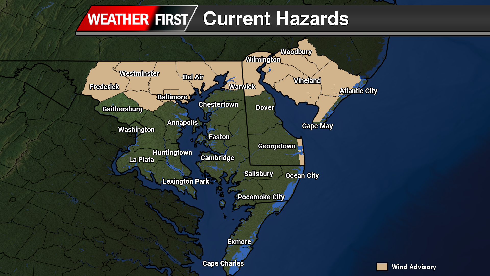
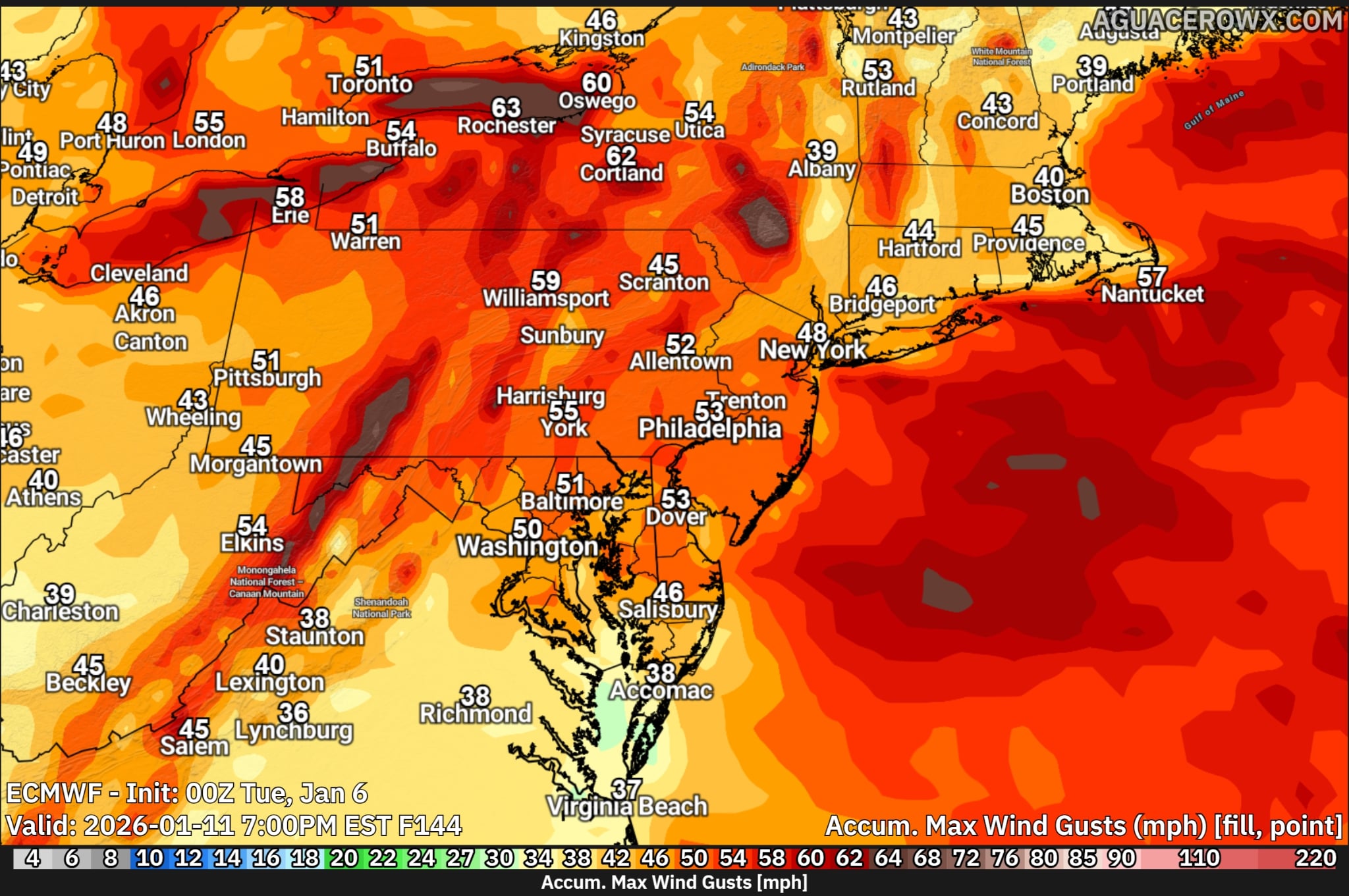
    A strong cold front moving through the Northeast is expected to bring a period of gusty winds through Sunday night, with the highest wind gusts occurring in the wake of the front. Widespread gusts of 40 to 55 mph are likely across much of the Mid-Atlantic and interior Northeast, including Pennsylvania, New Jersey, New York, and New England. Stronger gusts in the 55 to 65 mph range are possible across parts of upstate New York and areas downwind of the Great Lakes, where the pressure gradient will be strongest. Along the coast, especially across New Jersey, Long Island, and southern New England, gusts may exceed 50 mph, increasing the risk for downed trees, power outages, and travel disruptions.

    Here is a break down per state in the region…

    Delaware:
    Strong winds are expected behind the cold front, with peak gusts generally ranging from 45 to 55 mph statewide. The highest gusts are most likely along the coast and across the Delmarva Peninsula, where marine influence and a tighter pressure gradient could push isolated gusts slightly higher. These winds may lead to scattered power outages and difficult travel, especially on bridges and causeways.

    Maryland:
    Widespread gusts of 45 to 55 mph are forecast across much of Maryland, including the I-95 corridor from Baltimore to Washington. Western Maryland could see locally stronger gusts approaching 55 to 60 mph, particularly in higher elevations and along exposed ridgelines. The combination of saturated soils and strong winds may increase the risk for downed trees and power lines.

    Virginia:
    Much of northern and central Virginia can expect wind gusts between 40 and 50 mph, with higher gusts of 50 to 55 mph possible across eastern Virginia and along the Chesapeake Bay. Coastal and tidal areas may experience the strongest winds as colder air surges in behind the front. Impacts may include isolated power outages, difficult travel for high-profile vehicles, and minor coastal concerns.

  • Heavy Rains, Thunder, And High Winds On The Way Tonight Through Friday

    Heavy Rains, Thunder, And High Winds On The Way Tonight Through Friday

    A strong cold front is expected to move through the region later this evening, bringing periods of moderate to heavy rainfall, with the potential for a few embedded thunderstorms. Ahead of the front, a surge of unseasonably warm air continues to advance up the East Coast, allowing afternoon temperatures to rise into the upper 50s to near 60 degrees.

    ...WIND ADVISORY REMAINS IN EFFECT FROM 1 AM FRIDAY TO 1 AM EST
    SATURDAY...
    
    * WHAT...Southwest winds 20 to 30 mph with gusts up to 45 mph
      expected Thursday night through Friday morning. Winds turn to the
      northwest behind a strong cold front Friday afternoon. There may
      be a lull in the strongest wind gusts around midday Friday before
      the cold front passes through the region. Wind gusts in the wake
      of the front up to 50 MPH are possible.
    
    * WHERE...In Delaware, Delaware Beaches County. In New Jersey,
      Eastern Monmouth, Western Monmouth, Atlantic, Atlantic Coastal
      Cape May, Cape May, Coastal Atlantic, Coastal Ocean, Ocean, and
      Southeastern Burlington Counties.
    
    * WHEN...From 1 AM Friday to 1 AM EST Saturday.
    
    * IMPACTS...Gusty winds will blow around unsecured objects. Tree
      limbs could be blown down and a few power outages may result.
    
    PRECAUTIONARY/PREPAREDNESS ACTIONS...
    
    Winds this strong can make driving difficult, especially for high
    profile vehicles. Use extra caution.

    As the frontal boundary approaches, winds will strengthen significantly, with gusts of 40 to 50 mph possible across portions of New England and the Mid-Atlantic. A Wind Advisory is in effect for several areas. Rainfall totals are currently forecast to range between 0.50 and 1.50 inches, which will be beneficial in helping to alleviate ongoing drought conditions across much of the eastern United States.

    The sharp temperature gradient associated with the frontal passage may provide enough atmospheric instability to support a narrow line of embedded thunderstorms. Within this line, a strong low-level jet could allow isolated stronger wind gusts to mix down to the surface. While widespread severe weather is not anticipated, localized areas may experience brief heavy rainfall and gusty winds.

    Behind the front, gusty conditions will persist through Friday, with winds continuing to gust between 40 and 50 mph at times. Skies will gradually clear as cooler air filters into the region, bringing a return to sunshine and more seasonable temperatures.