Tag: high wind

  • Severe Weather & High Wind Threat Wednesday

    Severe Weather & High Wind Threat Wednesday

    As a powerful storm system begins to develop across the Central Plains, rounds of severe weather are expected from the deep south towards the Mid-Atlantic. As the month turns a new, we are now in Meteorological Spring and the severe weather threats begin showing up across the country.

    As a strong area of low pressure lifts up towards the Great Lakes, a tight pressure gradient will create tons of wind energy all over the eastern portions of the United States. On the warm side of the system as a powerful cold front advances eastward, instability and moisture coming from the Gulf will create a line of strong to severe thunderstorms to move through the Mid-Atlantic Wednesday afternoon.

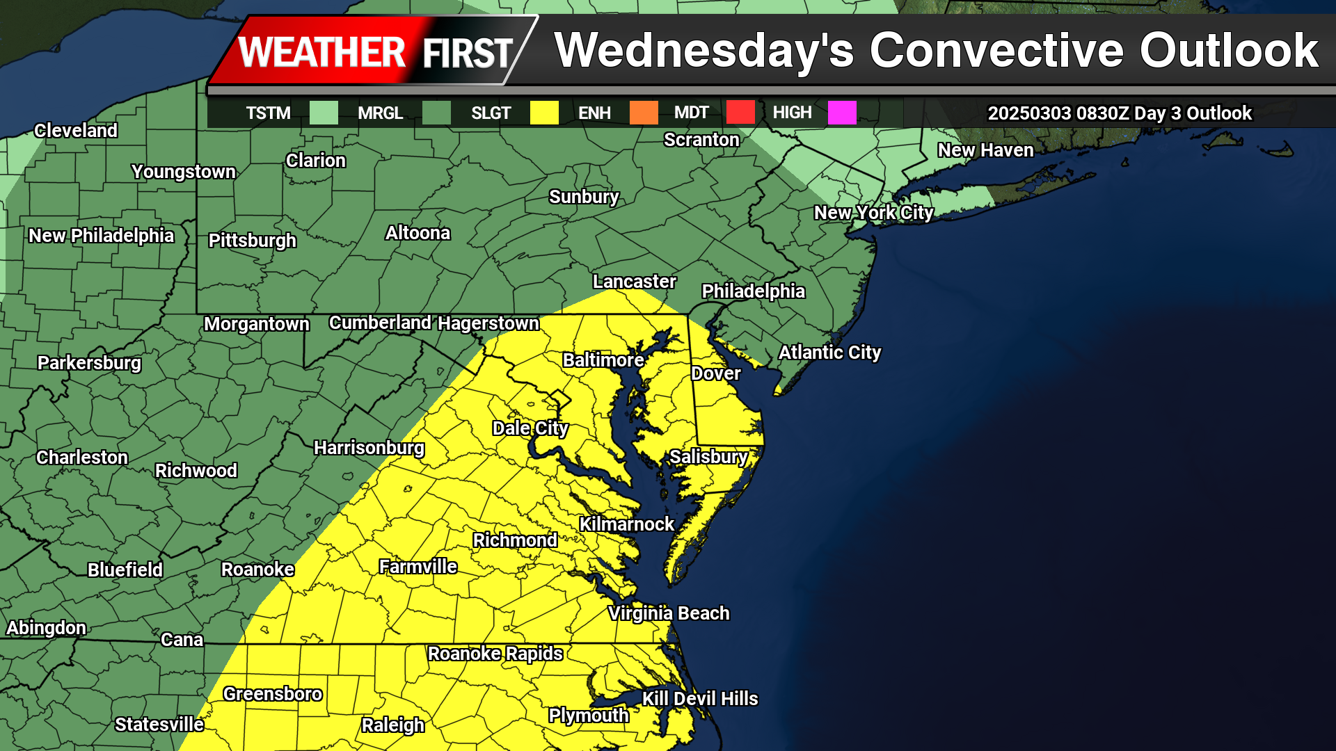
    A Slight Risk Of Severe Weather is in place across the Delmarva region down towards areas of the Carolinas. Primary threats will include strong damaging winds and the chance of a isolated tornado can not be ruled out. Storm Prediction Center meteorologist Jeremy Kerr had this to say about the overall threat.

       "Models indicate that surface dew points may increase into the 60s F
    in a corridor across the Carolinas through Virginia during the day.
    Latest NAM forecast soundings suggest that this might occur across
    parts of the Carolina Piedmont into coastal plain prior to the
    arrival of a remnant convective band emerging from the eastern Gulf
    States. Although lower/mid-tropospheric lapse rates are forecast to
    be rather weak, weak near-surface destabilization might become
    sufficient to support a risk for tornadoes and/or damaging straight
    line wind gusts, given forecast very large, clockwise curved
    low-level hodographs.

    In the wake of this initial band of convection, beneath a developing
    dry slot, northward moisture advection and insolation to the lee of
    the Blue Ridge may contribute to modest destabilization by late
    Wednesday afternoon. It appears that this will be aided by the
    leading edge of stronger mid-level cooling spreading to the east of
    the Appalachians, and accompanied by increasing thunderstorm
    development in the presence of strong deep-layer shear. Although
    forecast soundings suggest that low-level hodographs may become more
    modest by this time as the stronger low-level jet core spreads
    offshore, the environment may still become conducive to supercells
    with potential to produce severe wind, hail and perhaps a tornado."

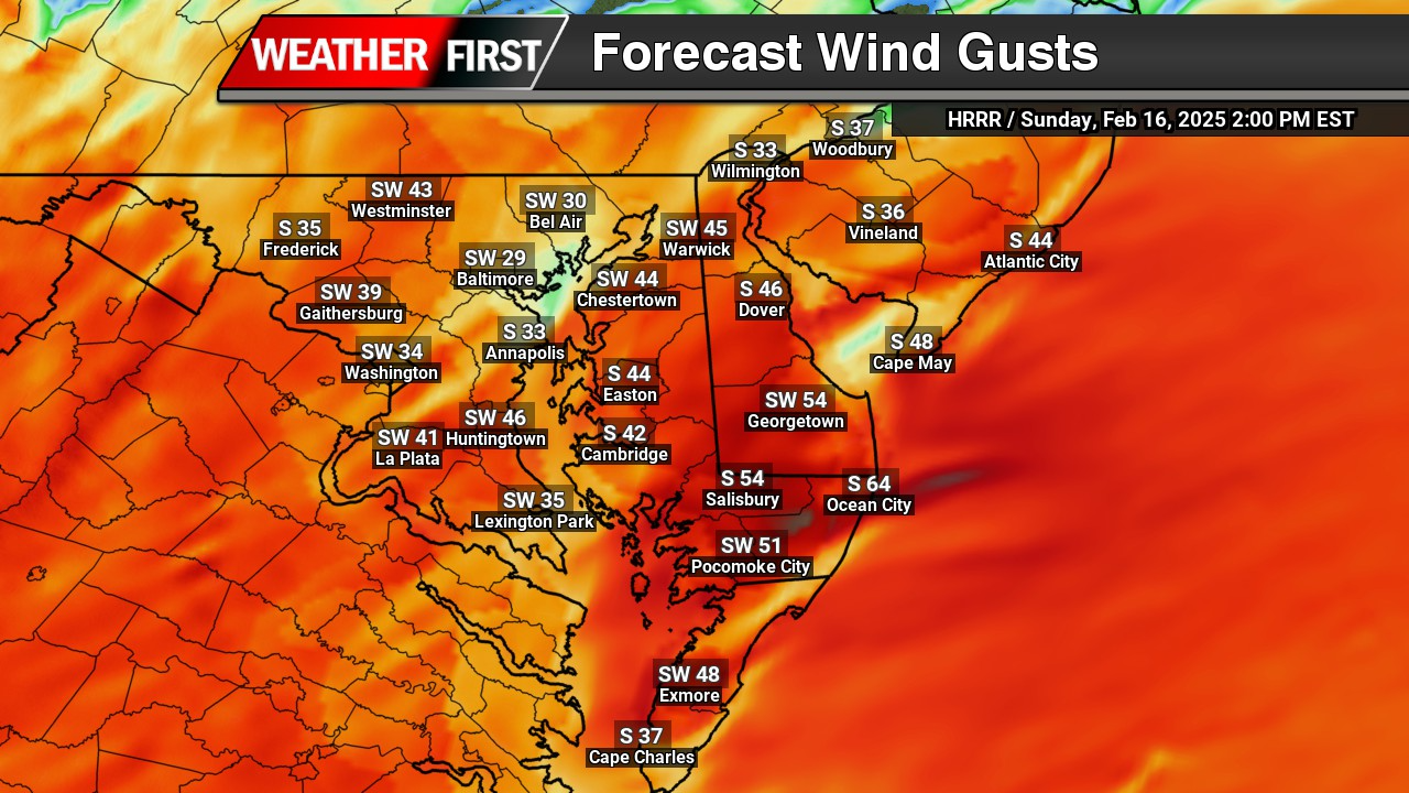
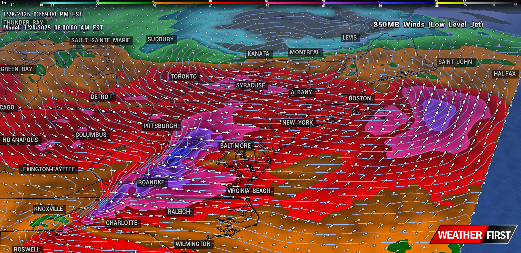
    Including the threat for severe weather, high non-thunderstorm wind damage is possible with a strengthening low level jet stream across the region. Model guidance has been showing very strong low level Jetstream winds of 60-80kts at 5000 feet which can be brought down to the surface from heavy rain or thunderstorms.

    As of this time, strong winds of 45 upwards to 60 mph are possible as this powerful cold front arrives during the afternoon hours on Wednesday. Winds of this magnitude can bring down trees and powerlines to create sporadic areas of power outages. Winds will continue to be strong after the cold front passes through as the pressure gradient remaining strong through Thursday.

  • High Wind Warning Issued For All Of The Mid-Atlantic: What You Need to Know

    High Wind Warning Issued For All Of The Mid-Atlantic: What You Need to Know

    A High Wind Warning is in effect from 10 AM Sunday to 6 PM Monday for all of Delaware, Maryland And Virginia. Strong west winds of 20 to 30 mph with gusts reaching up to 60 mph are expected throughout the region.

    Hazards of High Winds

    Winds of this magnitude can create significant hazards, including:

    • Falling Trees and Power Lines: The combination of strong gusts and saturated ground can easily topple trees, leading to widespread power outages and blocked roadways.
    • Structural Damage: High winds can cause damage to roofs, siding, fences, and outdoor furniture. Unsecured objects can become dangerous projectiles.
    • Difficult Travel Conditions: High-profile vehicles such as trucks, RVs, and buses will be especially vulnerable to strong crosswinds. Bridges and open roads will be hazardous.
    • Flying Debris: Loose objects such as garbage bins, decorations, and construction materials can be lifted and thrown, posing risks to people and property.

    How to Prepare for High Winds

    Taking proactive measures can help reduce damage and improve safety during this event:

    Before the Windstorm

    • Secure Outdoor Objects: Bring in or anchor loose items such as patio furniture, trash cans, and decorations.
    • Trim Trees and Branches: Remove weak limbs that could break and cause damage.
    • Charge Electronics: Power outages are likely, so ensure phones, flashlights, and backup batteries are fully charged.
    • Reinforce Windows and Doors: Close and lock all windows and doors. Consider storm shutters or plywood for additional protection.
    • Prepare an Emergency Kit: Include essentials such as flashlights, extra batteries, bottled water, non-perishable food, first-aid supplies, and necessary medications.

    During the Windstorm

    • Stay Indoors: Remain in the lower levels of your home, away from windows and exterior walls.
    • Avoid Unnecessary Travel: If you must drive, be extra cautious, especially on bridges and open roads.
    • Watch for Falling Debris: Avoid walking under trees, power lines, or unstable structures.

    After the Windstorm

    • Check for Damage: Assess your property for broken windows, roof damage, and fallen trees.
    • Report Power Outages: Contact your local utility provider to report outages or downed power lines. Stay at least 30 feet away from fallen wires.
    • Clear Debris Safely: Use caution when removing branches or other debris from your property.

    Stay Informed

    Monitor updates for real-time alerts and emergency instructions. Keeping informed can help you respond effectively to changing conditions.

    With proper preparation and caution, you can minimize the risks associated with this significant wind event. Stay safe and take necessary precautions to protect yourself, your family, and your property.

  • Windy Conditions Moving In For Wednesday: Powerful New England Storm System

    Windy Conditions Moving In For Wednesday: Powerful New England Storm System

    VALID: WEDNESDAY JAN 29TH @ 8AM

    Winds are beginning to intensify along the shoreline as a cold front steadily progresses through the region over the next several hours. Current observations indicate wind gusts already reaching up to 40 mph in some areas, with conditions expected to worsen as the front advances. By tomorrow, winds are forecast to strengthen further as the pressure gradient tightens, resulting in gusts up to 45 mph—nearing Wind Advisory thresholds.

    This increase in wind activity is tied to the influence of a strong low-pressure system currently diving southward from Canada. This system will bring widespread impacts, including areas of heavy snow squalls expected to develop across portions of upstate Pennsylvania and New York on Wednesday. Additionally, the intensification of the low-level jet stream, which is projected to reach speeds between 50 and 80 mph, will contribute to widespread gusty conditions across the mid-Atlantic and Northeast.

    Regions surrounding the Chesapeake Bay and Northern Maryland are expected to experience even stronger winds as the cold front and low-pressure system interact. In particular, wind acceleration along the eastern slopes of the Appalachian Mountains could produce gusts reaching as high as 50 mph. Higher-elevation areas, including parts of Western Maryland and Northern Virginia, where High Wind Warnings are in effect, are likely to encounter gusts exceeding 60 mph at times, presenting potential hazards to outdoor activities, infrastructure, and travel.

    Residents across the affected areas are encouraged to remain vigilant and secure loose objects outdoors, as these strong winds could lead to localized damage and power outages. Travelers should exercise caution, particularly in high-profile vehicles, due to the risk of crosswinds. Stay tuned to local forecasts for updates as this dynamic weather system unfolds.

    Wind Advisory In Effect From 11AM Weds – 6PM Weds

    …WIND ADVISORY IN EFFECT FROM 11 AM TO 6 PM EST WEDNESDAY…

    * WHAT…West winds 20 to 30 mph with gusts up to 50 mph expected.

    * WHERE…Portions of DC, central, north central, northeast, and

    northern Maryland, and northern Virginia.

    * WHEN…From 11 AM to 6 PM EST Wednesday.

    * IMPACTS…Gusty winds will blow around unsecured objects. Tree

    limbs could be blown down and a few power outages may result.

    PRECAUTIONARY/PREPAREDNESS ACTIONS…

    Winds this strong can make driving difficult, especially for high

    profile vehicles. Use extra caution.

  • Wash, Rinse, Repeat. Another High Wind Event On The Way

    Wash, Rinse, Repeat. Another High Wind Event On The Way

    Although the next storm system is another big one moving through the same areas as the last one, this one will not have that extreme punch like this one will. Still will be a nuisance to say the least.

    Strong winds will be a issue once again but thankfully we will NOT see those hurricane force wind gusts like we did but still in the higher end of the advisory category. Winds during the later overnight hours Friday into Saturday morning will gust 40-50 MPH on average but at times could gust 55 or higher especially near the coastlines. Which once again can lead to sporadic power outages and tree damage.

    Rainfall will once again will be a problem but not a extreme problem. A lot less rain is expected with this storm. Most areas will see upwards to a inch of rain but with saturated grounds, sporadic flooding is possible.

    Coastal Flooding will be a issue yet again with the New Moon still in play creating higher than normal tide cycles. At this time most tidal gauge forecasts are showing minor to moderate levels of tidal flooding Friday Night. Main flooding concerns will once again be in the Chesapeake and the mouth of the Delaware River.

  • Powerful Storm System Aims For Delmarva Tuesday Into Wednesday

    Powerful Storm System Aims For Delmarva Tuesday Into Wednesday

    Buckle up ladies and gentleman, tomorrow is going to be a very bumpy ride for us. Flooding rainfall, significant coastal flooding, and a serious high wind threat. And all of this begins during the afternoon hours Tuesday.

    Now we have been dealing with flooding since last month but what has me the most concerned is the absurd strength of these winds moving in tomorrow. A intense pressure gradient from a rapidly deepening surface low and strong high pressure system will generate a scenario of very intense winds. Strengthening of the low level winds in the low level jet-stream is some of the strongest I have seen for this region. Winds at 850-925mb level (<5000ft) screaming at 80-100 kts (92-115mph) is on the extreme end of likes I have not seen before. Now granted as we head down to the surface we are looking at reductions due to mixing but these winds are going to be fierce and nothing to play around with. My biggest concerns are for the southern and central portions of Delmarva where I believe we have a great shot of hitting hurricane force winds gusts at or exceeding 74 mph where the High Wind products are in place. Many locations will be seeing winds gusting 60 mph or greater at times. Power outages, downed trees, structural damage are all possible with these kinds of winds.

    Of course more flooding concerns for the region with the extremely saturated grounds from last months dump of 10-12 inches of rainfall. Another 2-4 inches are possible prompting a MDT risk from the WPC on excessive rainfall through the western shore of Maryland and northern Delmarva. Flood watches are in place in response to the heavy amounts of rainfall.

    Moderate to Major Flood Stage is expected across the Chesapeake Bay and the mouth of the Delaware Bay with the upcoming high cycles Tuesday Night and Wednesday. Some of which forecasts at certain tidal gauges could hit record levels! Atlantic coastal regions even though will have extremely large swell, winds will be parallel to the coast to keep tide levels down but will be funneling in significantly through the Chesapeake and Delaware Bay regions. Those who live near these water ways, make preparations to evacuate or seek higher ground if flood waters becoming inundating in your areas. Also make preparations to help protect your property from flood waters.

  • Growing Concerns For A High Wind Event Thursday Night-Friday

    Growing Concerns For A High Wind Event Thursday Night-Friday

    Growing concerns that we may be dealing with a high wind event evolving during the overnight hours on Thursday into the day on Friday. All thanks to a rapidly developing storm system from the Central Plains that will be driving a cold front through the Eastern Half of the nation. Not to mention the very warm temperatures that will be following the upcoming event as well.

    850mb Winds: Low Level Jetstream

    The main driver for the strong winds we are expecting is the enhancement of the nocturnal low level Jetstream which sits about 5000 feet above the surface. While this area of low pressure continues to strengthen as it crosses into the Great Lakes, the gradient between this area of low pressure and a strong high pressure system off the East Coast will really start enhancing those winds. Forecast models have been quite bold with 70-80kts (80-90 mph) low level jet at 5000 feet which is very strong. Now keep in mind, those winds are pretty high off the ground and unlikely we will see those reaching the surface. With the aid of falling precipitation, we will see some of those stronger winds above he surface to mix down.

    With the strong wind energy with that low level jet, no surprise we can see wind gusts 40-55 mph at the surface during the nighttime hours as the cold front edges closer. Winds of this speed can knock down some tree limbs and cause some sporadic power outages at times. Gusty winds will continue throughout the day on Friday even behind the front.

  • High Wind Event With Coastal Flooding Concerns Sunday Night

    High Wind Event With Coastal Flooding Concerns Sunday Night

    Not only we have to deal with some heavy rainfall, a little bit of snow for the northern areas of Delmarva and the Maryland Western Shore. There’s an event that is sleeping under the radar that has my full attention. When that low starts dropping below 990mb, that low level jet stream is very strong being pulled into this surface low.

    70-80kt Winds at 850mb ( Low Level Jet)

    Anytime I start seeing winds at 5000ft getting over 60kts, I get a bit uneasy in the damaging wind department. This is a long fetch stream of onshore winds we are talking about from the Gulf Stream. There is going to be a lot of wind energy pushing on the east side of this low. And it’s all onshore flow too. There’s more issues with this as well.

    Winds at the surface are showing widespread wind gusts of 40-60 mph from the east and southeast. Another problem surfaces as well. We have a high tide cycle that’s expected during the evening hours Sunday Night. To add more salt in the wound, this weekend is a full moon as well. So take 40-60mph surface winds, plus onshore flow, plus a high tide cycle, and a full moon, it’s not going to be a fun time for a coastal locations this weekend. Strongest winds appear to be in a window from 8pm Sunday until 4am Monday.

    Already a few tidal forecast in the region showing Moderate Flood Stage forecasts like this one in Crisfield. So we really got to watch our coastal regions Sunday night for flooding concerns.