Tag: freezing rain

  • Significant Winter Storm Set to Impact the Delmarva Region Tuesday into Wednesday

    Significant Winter Storm Set to Impact the Delmarva Region Tuesday into Wednesday

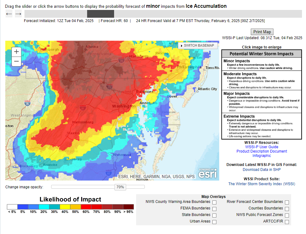
    Another winter storm is set to impact the region as we move into Tuesday and Wednesday, bringing a mix of heavy snow, ice, and rain across the Delmarva Peninsula. Snow and wintry precipitation will begin Tuesday afternoon and continue through Wednesday morning, leading to widespread travel disruptions and hazardous conditions.

    This storm is developing as a new area of low pressure forms over the Deep South and tracks northeastward along a stalled frontal boundary. At the same time, a strong high-pressure system to the north will funnel cold air into the region, setting the stage for a classic overrunning event. In this setup, warm, moisture-laden air from the Gulf of Mexico moves over the dense, cold Arctic air advancing southward from Canada, creating widespread heavy snowfall from the Midwest into the Mid-Atlantic. This process, known in meteorology as isentropic ascent, drives the formation of clouds and precipitation as the warm air rises and cools.

    In a winter storm overrunning setup, isentropic ascent occurs when warm, moist air is forced to rise over a cold, dense air mass at the surface. This typically happens along a stationary front or warm front, where the warm air follows sloping isentropic surfaces (constant potential temperature). As the air rises, it cools adiabatically, leading to cloud formation and precipitation.

    Since winter storms involve subfreezing surface temperatures, this precipitation can fall as snow, sleet, or freezing rain, depending on the temperature profile. Stronger isentropic ascent enhances moisture transport and lift, leading to heavier and more widespread winter precipitation.

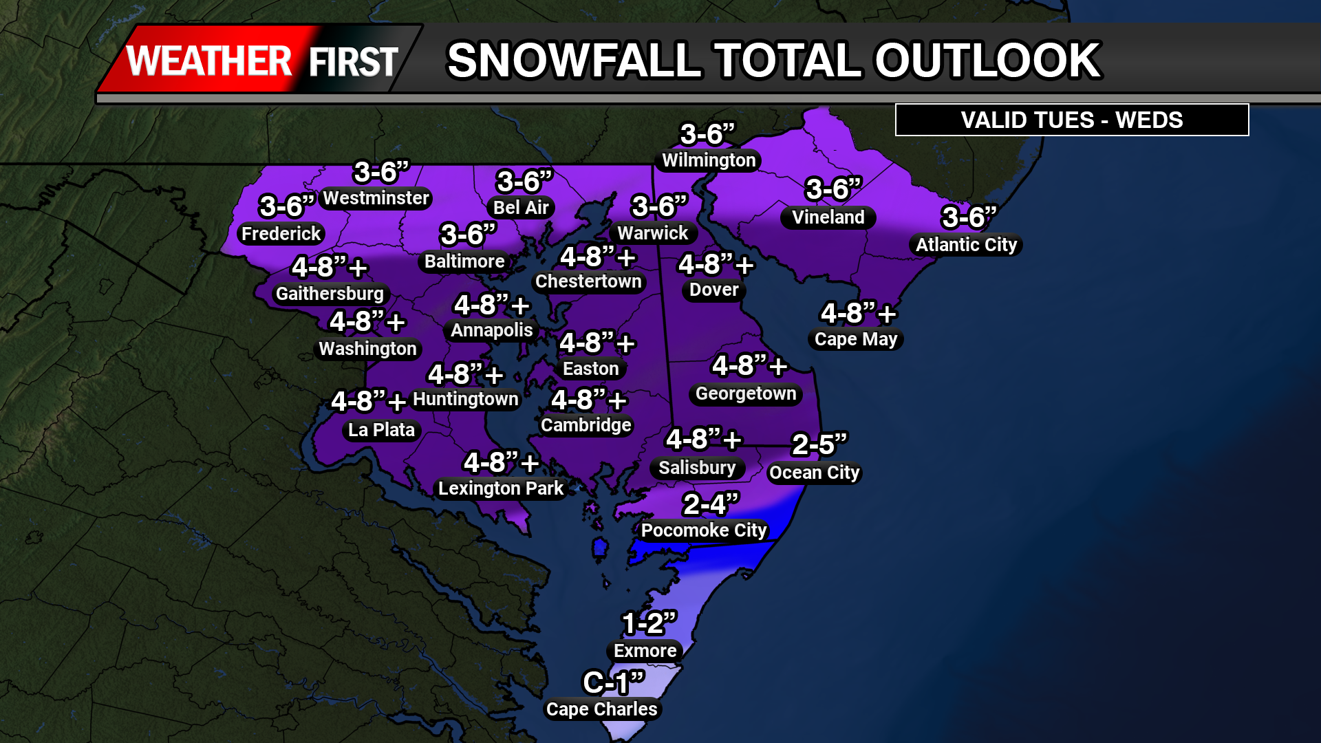
    Snowfall Potential and Accumulation Estimates

    The latest ensemble model guidance indicates a significant increase in snowfall probabilities across central and northern Delmarva. There is now a 60-90% chance of at least 3 inches of snow north of the Maryland-Delaware state line, with 40-60% probabilities for accumulations exceeding 6 inches from Delmar, DE to Smyrna, DE.

    The heaviest snowfall totals are expected between the MD/DE line and Smyrna, where an average of 4 to 8 inches is forecast. This extends westward toward Washington, D.C.. However, localized snow bands could produce isolated totals up to 10 inches, particularly across central Delmarva.

    Coastal and Southern Delmarva Impacts

    Further south, near the coastal areas including Berlin and Pocomoke City, the storm will begin as snow but may transition to a mix of snow, sleet, and rain as temperatures rise above freezing. This will reduce overall snowfall totals due to melting overnight Tuesday into early Wednesday.

    Meanwhile, areas further north will remain all snow, though the intensity may be slightly lower compared to central Delmarva. Regardless, this storm is shaping up to be a significant winter weather event across the region, bringing hazardous travel conditions and potential disruptions.

    Stay tuned for updates as forecast details continue to evolve.

  • Wintry Mix Threatens Central and Northern Delmarva Again with Ice Accretion and Slick Travel This Weekend

    Wintry Mix Threatens Central and Northern Delmarva Again with Ice Accretion and Slick Travel This Weekend

    A complex winter weather system is set to impact portions of central and northern Delmarva, bringing a mix of snow, sleet, and freezing rain as temperatures hover near the freezing mark towards early Saturday afternoon. This system will create hazardous travel conditions, especially in areas where freezing rain leads to ice accretion.

    Weather Setup and Model Guidance

    Latest guidance from the ICON, GFS, and ECMWF suggests that cold air at the surface will remain entrenched across northern Delmarva, allowing for a prolonged period of wintry precipitation before a gradual changeover to rain. Meanwhile, high-resolution CAMS guidance, including the HRW-WRF & NAM12KM, continues to highlight higher localized areas of ice accumulation, particularly in northern regions where cold air remains stubborn.

    As the system moves through, precipitation is expected to start as a wintry mix of snow, sleet, and freezing rain across northern and central Delmarva, with surface temperatures struggling to rise above 32°F. By early afternoon, warmer air aloft will cause much of central Delmarva to transition to plain rain, while northern Delmarva may see continued ice accretion before the system exits early Sunday.

    Potential Ice Accretion and Travel Hazards

    • Ice Accumulation: Up to 0.10” of ice is possible across northern & central Delmarva, with localized higher amounts in areas where freezing rain persists.
    • Travel Impacts: Slick roadways and hazardous conditions are expected, particularly on bridges and overpasses. Untreated surfaces may become icy and dangerous.
    • Timing: The wintry mix will continue through early afternoon, with a gradual transition to rain in central Delmarva through the evening hours. Northern areas may hold onto freezing rain longer before precipitation moves out early Sunday morning.

    Stay Weather Aware

    Residents across central and northern Delmarva should stay updated with the latest forecasts, as even small changes in temperature could impact precipitation type and ice accumulation. If traveling, exercise caution and allow extra time, especially in areas where freezing rain may linger.

  • Freezing Drizzle Threat Wednesday Night into Thursday Morning for Central and Northern Delmarva

    Freezing Drizzle Threat Wednesday Night into Thursday Morning for Central and Northern Delmarva

    A period of freezing drizzle is expected to develop across central and northern Delmarva Wednesday night, bringing the potential for hazardous travel conditions before precipitation transitions to plain rain by Thursday morning. The greatest threat for icy conditions will be across northern Delmarva, where temperatures will be more favorable for freezing precipitation.

    What is Freezing Drizzle?

    Freezing drizzle occurs when supercooled liquid droplets fall from the sky and freeze upon contact with surfaces such as roads, sidewalks, trees, and vehicles. Unlike freezing rain, which tends to form larger droplets, freezing drizzle consists of much smaller droplets that can create a thin but dangerous glaze of ice. Because it often accumulates subtly, freezing drizzle can be particularly hazardous as it may not appear as obvious as snow or sleet.

    Timing & Transition to Rain

    Freezing drizzle is expected to develop shortly after sundown Wednesday evening and will continue off and on through the night. Areas across northern Delmarva will experience the most significant threat of icy conditions due to colder surface temperatures sticking around a bit longer. As temperatures gradually rise early Thursday morning, all areas will transition to plain rain by mid-morning, reducing the risk of ice accumulation.

    Potential Impacts

    Even a light glaze of ice can lead to dangerous conditions, including:

    • Slippery Roads & Sidewalks – Even untreated surfaces may quickly become icy, increasing the risk of accidents and falls.
    • Icy Bridges & Overpasses – Elevated surfaces freeze faster than ground-level roads, making them particularly hazardous.
    • Thin Ice Accumulation on Vehicles – Ice may form on car windshields and other exposed surfaces, requiring extra time for de-icing before travel.

    If you must travel Wednesday night into early Thursday morning, use caution, reduce speed, and be prepared for slick spots, especially in northern Delmarva. Stay updated with the latest forecasts and advisories as conditions evolve.