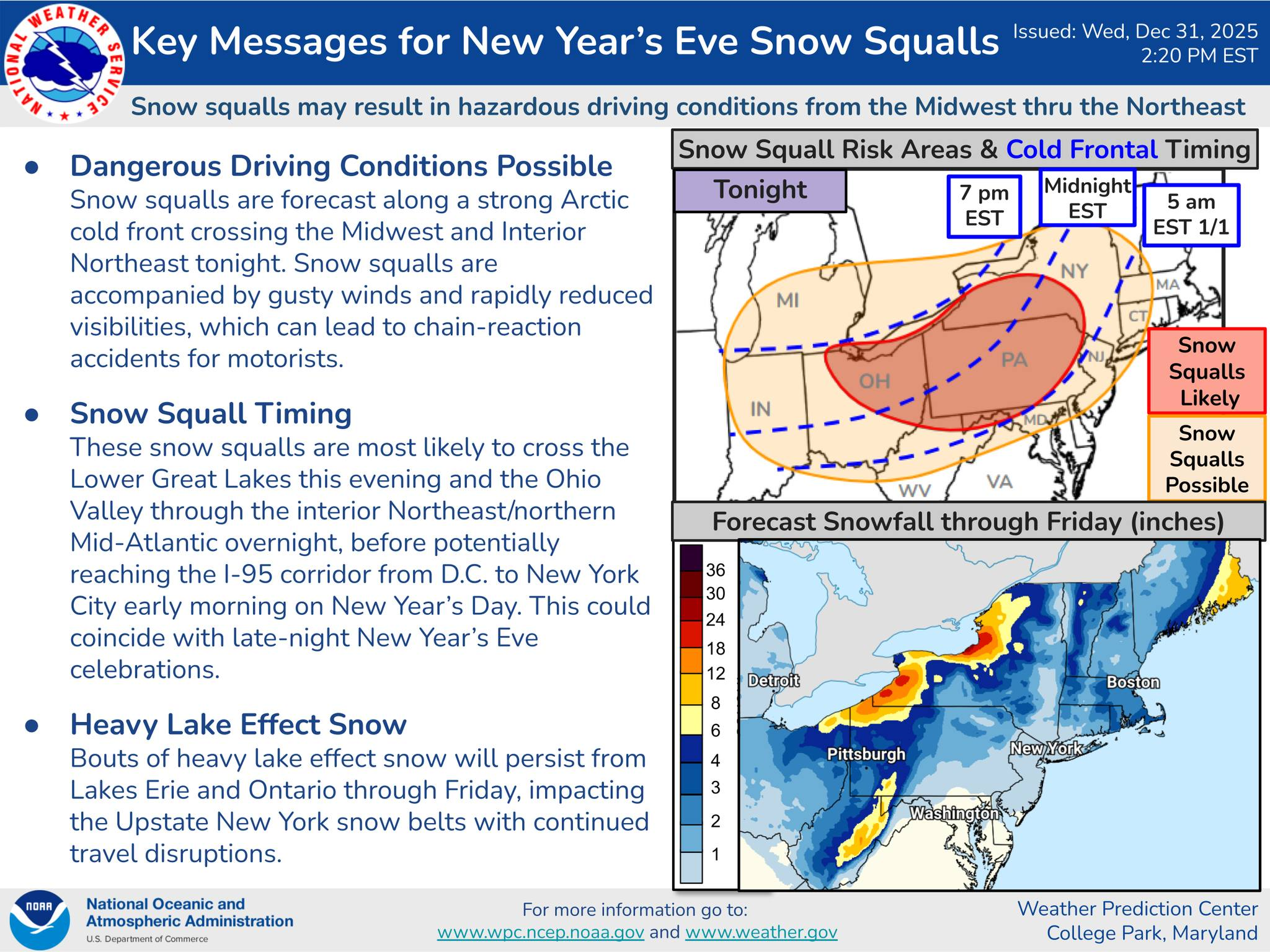

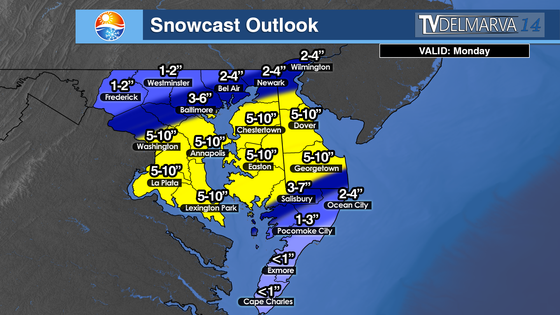
Drivers across Delmarva, Maryland, and much of Pennsylvania are being urged to use caution this New Year’s Eve as a strong Arctic cold front moves through the region, bringing the potential for sudden snow squalls and dangerous travel conditions. While snowfall amounts are expected to be brief and localized, the intensity of these squalls could quickly reduce visibility to near zero and lead to slick, snow-covered roadways in a matter of minutes.
Forecasters say the greatest risk for snow squalls will develop this evening across western and central Pennsylvania before shifting east overnight into eastern Pennsylvania, northern Maryland, and parts of Delmarva. The squalls may be accompanied by gusty winds, creating whiteout conditions along major travel routes including Interstates 76, 81, 83, 95, and portions of U.S. Route 13 across the Delmarva Peninsula.
Timing is a major concern, as the snow squalls could impact travel during peak New Year’s Eve festivities and late-night returns home. In Maryland, areas north of the Baltimore Washington corridor stand the best chance of seeing brief but intense snow bursts overnight, while Delmarva may see fast-moving squalls or snow showers capable of briefly coating roadways, particularly in northern and interior sections in the early morning hours.
Even though total snowfall amounts will be limited, the rapid drop in temperatures behind the front could allow any moisture on roadways to freeze quickly, increasing the risk of icy conditions. Motorists may encounter rapidly changing visibility and road conditions with little advance warning.
Looking ahead, much colder air settling in behind the front will fuel lake-effect snow across western and north-central Pennsylvania through Friday. While this will not directly impact Delmarva or most of Maryland, it could lead to continued travel disruptions for those heading north or west after the holiday.
Officials urge drivers to slow down, increase following distance, and avoid unnecessary travel during squalls. Snow squalls are often short-lived but can be just as dangerous as longer-duration winter storms, especially during busy holiday travel periods.


 Severe Cold Weather Alert: An Arctic air mass is forecasted to sweep across a significant portion of the United States this weekend!
  From the Rockies to the Great Plains, this frigid air will reach the Gulf Coast by Saturday night and move towards the Eastern Seaboard by Sunday evening.
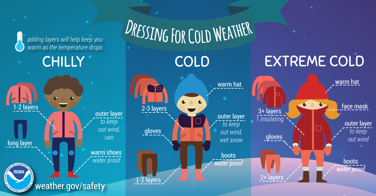
 Extremely Low Wind Chills: The Rockies, northern Plains, and Upper Midwest are expected to experience dangerous wind chills as low as -30°F or even lower from Saturday through Tuesday. This extreme cold poses serious risks of hypothermia and frostbite for individuals exposed to these conditions. If you plan to travel, ensure you have a cold weather survival kit prepared for your safety.
 Furthermore, below-zero wind chills are anticipated to extend into the southern Plains and the Ohio Valley from Sunday night through Tuesday. The hazardous cold is likely to persist along the Gulf Coast and across the Southeast U.S. for much of the following week. Stay warm and take all necessary precautions during this severe cold snap!


