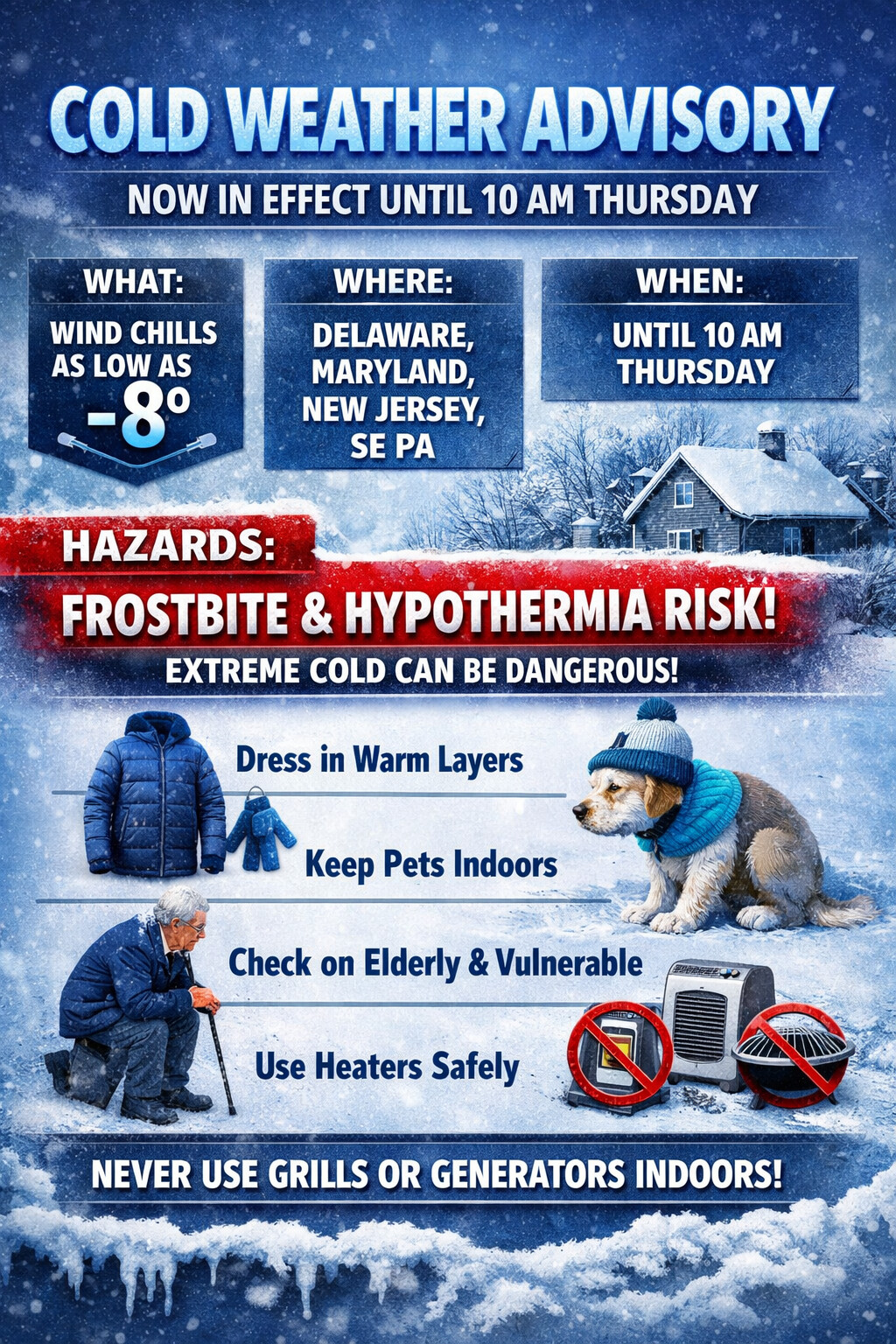
...COLD WEATHER ADVISORY NOW IN EFFECT UNTIL 10 AM EST THURSDAY...

* WHAT...Very cold wind chills as low as 8 below.

* WHERE...Portions of central, northern, and southern Delaware,
  northeast Maryland, central and southern New Jersey, and southeast
  Pennsylvania.

* WHEN...Until 10 AM EST Thursday.

* IMPACTS...The cold wind chills as low as 10 below zero could
  result in hypothermia if precautions are not taken. Frostbite and
  hypothermia will occur if unprotected skin is exposed to these
  temperatures.

PRECAUTIONARY/PREPAREDNESS ACTIONS...

Use caution while traveling outside. Wear appropriate clothing, a
hat, and gloves.

Keep pets indoors as much as possible.

Make frequent checks on older family, friends, and neighbors. Ensure
portable heaters are used correctly. Do not use generators or grills
inside.
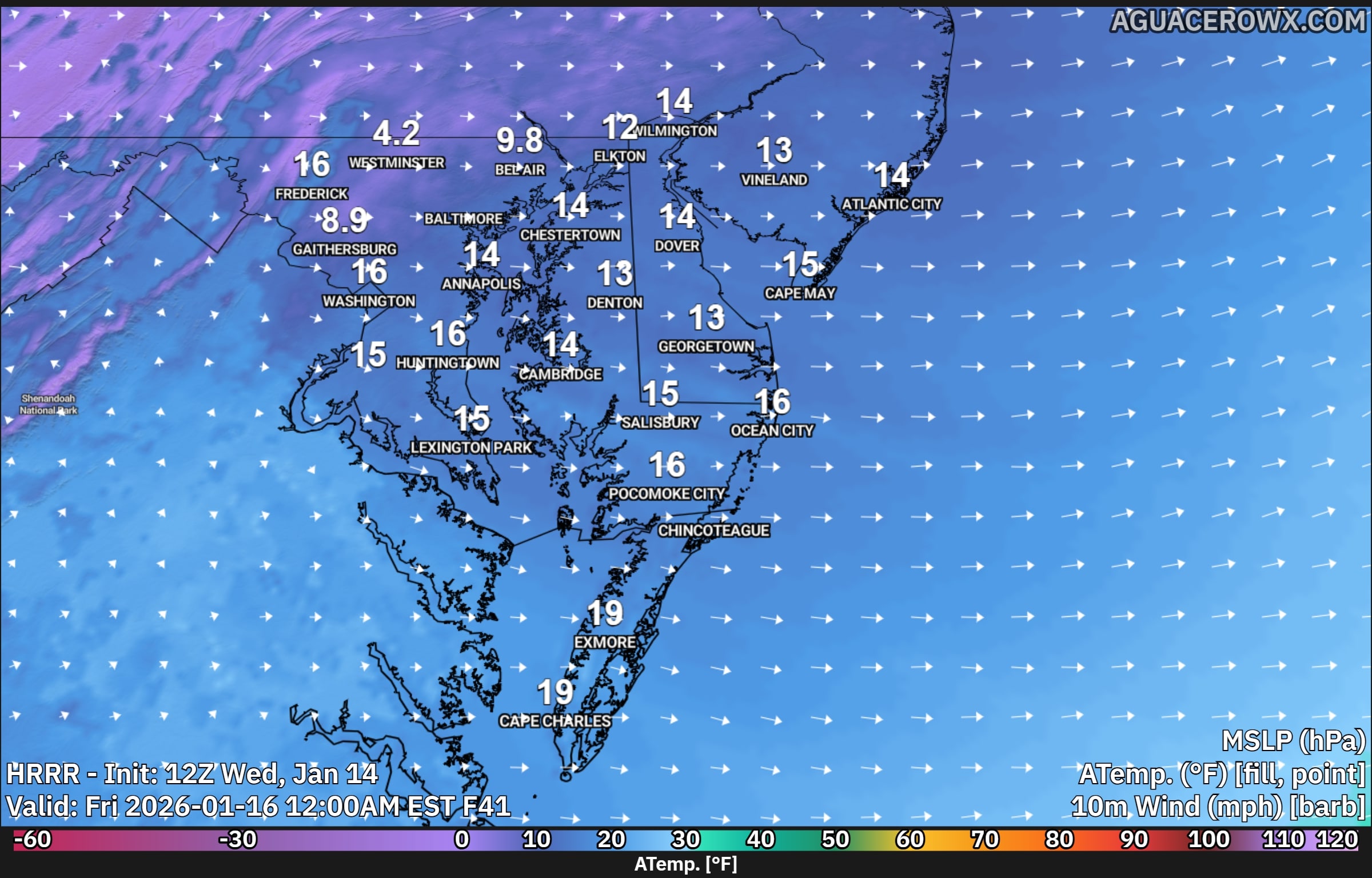
A surge of colder air behind a cold front will bring sharply colder temperatures and strong winds to the region late Thursday into Friday, creating dangerously cold wind chills.
After the cold front moves through Thursday morning, strong cold air will continue to pour into the area through Friday morning. Afternoon temperatures on Thursday are expected to remain stuck in the low to mid 30s, while west winds increase to 15 to 20 mph with gusts reaching 30 to 35 mph. These gusty winds will make it feel much colder, with wind chills struggling to climb out of the upper teens and lower 20s during the day.
As temperatures fall Thursday night, most locations will drop into the mid teens to near 20 degrees by early Friday morning. Although winds will ease slightly overnight, steady west winds of 10 to 15 mph will persist. This combination of cold air and lingering wind will cause wind chills to fall into the single digits across much of the area by daybreak Friday, with below zero wind chills possible in the higher elevations of the southern Poconos.
By Friday morning, the strongest push of cold air will begin to ease, allowing winds to turn more southwesterly and temperatures to slowly recover. Afternoon highs on Friday will range from the upper 20s to the mid 30s. However, continued breezy conditions will keep wind chills in the 20s for much of the day, making it feel colder than the actual temperatures suggest.
Residents are encouraged to dress in layers, limit prolonged exposure to the cold, and take precautions to protect pets, pipes, and vulnerable populations during this stretch of cold and windy weather.
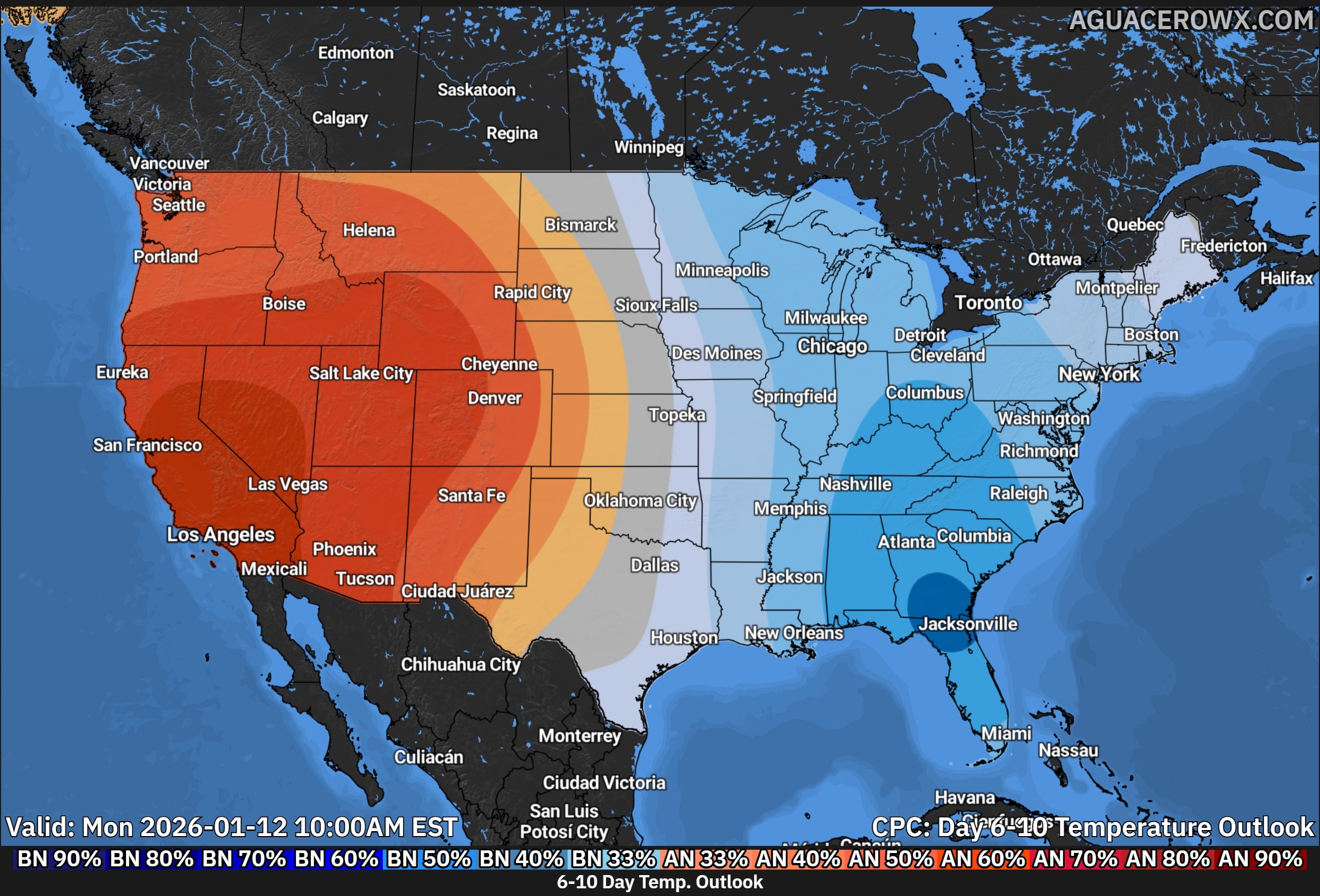
A noticeable shift toward colder than average temperatures is expected to develop across much of the eastern United States over the next few weeks, according to the latest temperature outlooks from the Climate Prediction Center. Multiple forecast periods show increasing confidence that below average temperatures will dominate the East, including the Mid Atlantic and Delmarva region.
6 to 10 Day Outlook: Cold Begins to Push East
During the 6 to 10 day period, colder air is forecast to expand across much of the eastern half of the country. Below average temperatures are favored from the Midwest through the Ohio Valley and into the Mid Atlantic and Southeast. The Delmarva Peninsula falls within this colder zone, signaling a transition away from recent mild conditions.
While the strongest cold anomalies are centered farther west early on, the overall pattern supports repeated intrusions of cooler air into the region. Daytime highs are expected to trend several degrees below normal, with overnight lows becoming more seasonable to colder than average.
8 to 14 Day Outlook: Below Average Temperatures Become More Established
Confidence increases during the 8 to 14 day period as below average temperatures become more firmly established across the eastern United States. The cooler air mass expands and deepens, covering much of the Mid Atlantic, Northeast, and Southeast.
For Delmarva, this period favors a sustained stretch of cooler conditions, especially during nighttime hours. Persistent northwest flow behind passing systems may keep temperatures suppressed for several days at a time.
Weeks 3 to 4: Colder Pattern Persists
Looking ahead into weeks 3 and 4, the temperature outlook continues to favor below average conditions across much of the eastern United States. While forecast confidence naturally decreases at longer ranges, the signal remains consistent for a cooler than normal pattern.
Across Delmarva, this suggests limited warm ups and continued winterlike temperatures heading into late January. Brief periods of moderation may occur, but cooler air is expected to return frequently as the broader pattern remains favorable for below average temperatures.
What This Means for Delmarva
For residents across Delaware, Maryland’s Eastern Shore, and Virginia’s Eastern Shore, the next few weeks are expected to feature a noticeable chill compared to normal January conditions. While temperatures will fluctuate, the overall trend points toward a colder pattern settling in across the region.
Overall, the outlook supports a sustained period of below average temperatures across the eastern United States, with Delmarva remaining solidly within the cooler regime through much of the remainder of January.
With days as of this past week constantly being int he 50’s and even 60’s, many wonder where did winter go? Normally in the winter months across the lower 48 go through a longer duration warming trend as a recharge of the overall pattern and sign are pointing at a return to more winter weather moving back across the eastern half of the US.
Weather models are all onboard for a bigger shift in the overall weather pattern across the Northern Hemisphere Mainly what’s going on across the Pacific Ocean which is the biggest driver to the Lower 48 weather pattern for supplying the cold air and the active storm track. One thing that is peaking my interests is a significant drop in the Eastern Pacific Oscillation during the time period of the 14th-20th.
A very large negative Eastern Pacific Oscillation, or EPO, is a significant large scale weather pattern that can strongly influence temperature and storm tracks across the United States, especially during the fall and winter months.
When the EPO is strongly negative, a powerful ridge of high pressure builds over the eastern Pacific, often near Alaska and the Gulf of Alaska. This ridge acts as a blocking feature, forcing the jet stream to buckle sharply northward into Alaska and then dive southward downstream into western and central North America. As a result, Arctic air is displaced south out of Canada and into the United States.
For the western United States, a negative EPO often brings colder than normal temperatures, particularly to the Pacific Northwest and northern Rockies. The ridge offshore can suppress precipitation along parts of the West Coast, leading to drier conditions in California, while the colder air aloft supports snow in the higher elevations of the Northwest and Intermountain West when storms are able to undercut the ridge.
Across the central and eastern United States, the downstream response to a negative EPO is often a broad trough, which allows cold air to spill southward. This can lead to below normal temperatures across the Plains, Midwest, and East Coast. When moisture is available, this pattern can be favorable for winter storms, as cold air at the surface can interact with southern stream systems or coastal lows.
The strength of the negative EPO matters. A weak negative phase may only produce brief or modest cold shots, while a strongly negative EPO can support prolonged cold outbreaks, sometimes reaching deep into the southern United States. This setup can also increase the likelihood of sharp temperature swings if the blocking ridge eventually breaks down.
Weather across the Eastern US might get very interesting going forward into the mid-month.
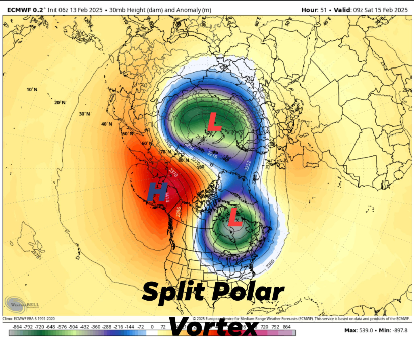
A significant meteorological event is poised to impact the contiguous United States next week, as the stratospheric polar vortex undergoes a rare split, leading to an arctic outbreak with temperatures projected to plummet 20 to 40 degrees below normal between February 17th and 23rd.
Understanding the Polar Vortex Split
The polar vortex is a large area of low pressure and cold air surrounding both of Earth’s poles, residing in the stratosphere. Typically, this vortex remains stable, containing the cold air within the polar regions. However, certain atmospheric conditions can disrupt this stability, leading to a phenomenon known as a Sudden Stratospheric Warming (SSW). During an SSW, large-scale atmospheric waves, called Rossby waves, propagate into the stratosphere, weakening the polar vortex. If these waves are strong enough, they can cause the vortex to split into two or more smaller vortices. This split allows frigid polar air to descend into mid-latitude regions, including parts of the United States.
Projected Temperature Anomalies
Forecast models, including the European Centre for Medium-Range Weather Forecasts (ECMWF) and the Global Forecast System (GFS), indicate that one of the split vortex cores will migrate over North America. This movement is expected to usher in a significant cold air outbreak across the northern, central, and eastern United States. Temperature anomalies during this period are projected to range from 20 to 40 degrees below normal.
Potential for Increased Winter Storm Activity
The influx of arctic air sets the stage for enhanced winter storm development. As the cold air interacts with warmer, moisture-laden systems from the south, the likelihood of snow, ice, and mixed precipitation events increases. Regions across the central and eastern U.S. should prepare for potential winter storms during this period, with the possibility of significant snowfall and hazardous travel conditions.
Preparing for the Arctic Outbreak
Residents are advised to monitor local weather forecasts and heed warnings from meteorological authorities. Preparations should include:
Ensuring adequate heating supplies and checking the functionality of heating systems.
Stocking up on essential items in anticipation of potential disruptions.
Taking necessary precautions for vulnerable populations, including the elderly and those with health conditions.
Preparing vehicles for winter conditions, including checking antifreeze levels and ensuring tires are suitable for snow and ice.
By staying informed and taking proactive measures, individuals and communities can mitigate the impacts of this impending arctic outbreak.
A few changes going into this winter season with the replacement of Wind Chill products. Introducing Extreme Cold Weather products with “Cold Weather Advisories” now in place for areas of the Delmarva region starting tonight through Wednesday morning.
...COLD WEATHER ADVISORY NOW IN EFFECT FROM 6 PM THIS EVENING TO
NOON EST WEDNESDAY...

* WHAT...Very cold wind chills as low as 7 below expected.

* WHERE...Delaware, northeast Maryland, central to southern New
  Jersey, and southeast Pennsylvania.

* WHEN...From 6 PM this evening to noon EST Wednesday.

* IMPACTS...The cold wind chills could result in hypothermia if
  precautions are not taken. Frostbite and hypothermia will occur if
  unprotected skin is exposed to these temperatures.

PRECAUTIONARY/PREPAREDNESS ACTIONS...

Use caution while traveling outside. Wear appropriate clothing, a
hat, and gloves.

Keep pets indoors as much as possible.

Make frequent checks on older family, friends, and neighbors. Ensure
portable heaters are used correctly. Do not use generators or grills
inside.
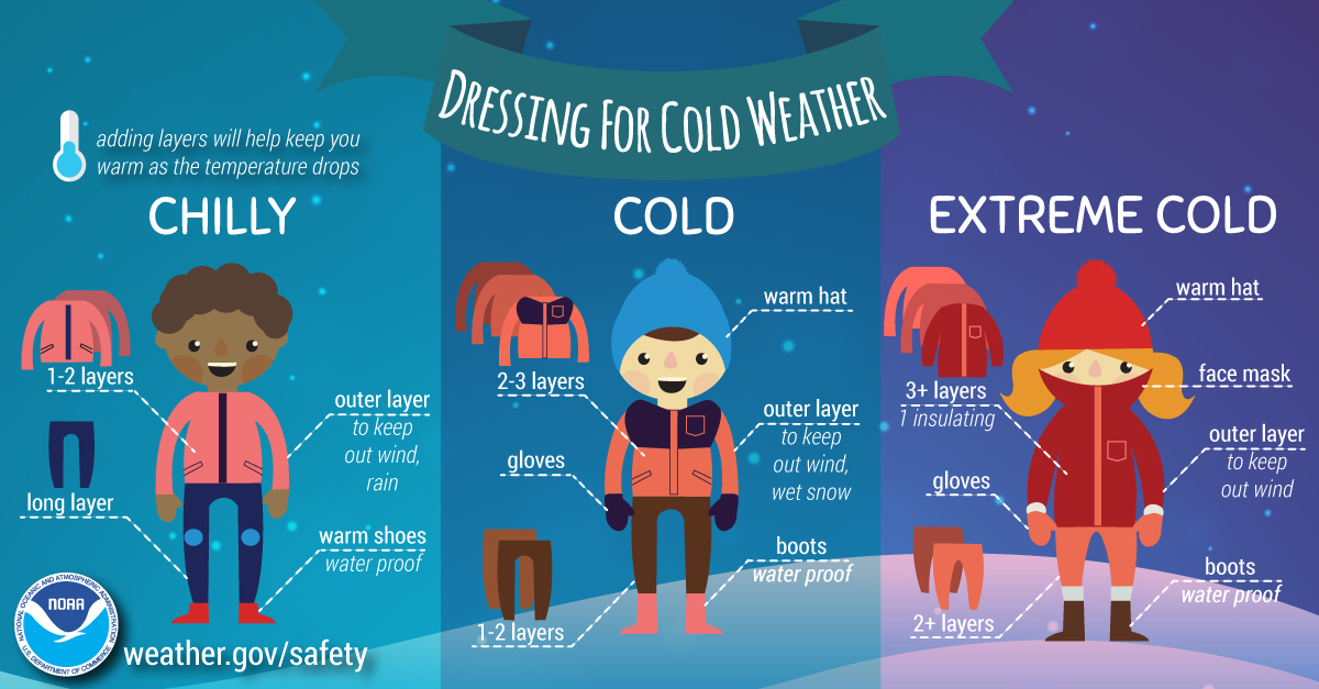
Extreme Cold Warning vs Watch and Cold Weather Advisory
Extreme Cold Warning: Take Action! An Extreme Cold Warning is issued when dangerously cold air temperatures or wind chill values are expected or occurring. If you are in an area with an Extreme Cold Warning, avoid going outside. If you have to go outside, dress in layers, cover exposed skin, and make sure at least one other person knows your whereabouts. Update them when you arrive safely at your destination.
Extreme Cold Watch: Be Prepared. An Extreme Cold Watch is issued when dangerously cold air temperatures or wind chill values are possible. As with a Warning, adjust your plans to avoid being outside during the coldest parts of the day. Make sure your car has at least half a tank of gas, and update your winter survival kit.
Cold Weather Advisory: Be Aware. A Cold Weather Advisory is issued when seasonably cold air temperatures or wind chill values, but not extremely cold values, are expected or occurring. Be sure you and your loved ones dress appropriately and cover exposed skin when venturing outdoors.
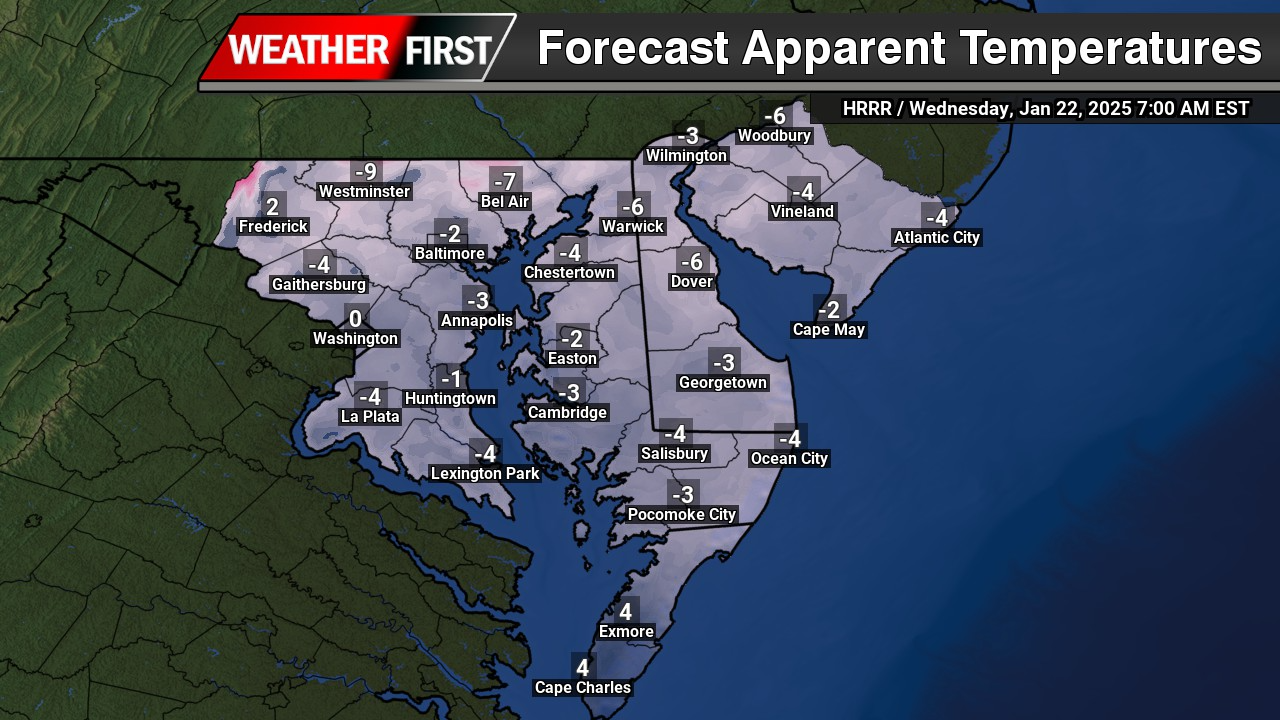
Dangerous wind chills dropping down below zero are expected for the next few nights here on Delmarva as winds will be gusting 20-30 mph. Temperatures dropping down to the single digits making it the coldest nights we have seen in the last several years.
Extremely cold air comes every winter into at least part of the country and affects millions of people across the United States. The arctic air can be dangerous. Combined with brisk winds, dangerously cold wind chill values can result. People exposed to extreme cold are susceptible to frostbite and can succumb to hypothermia in a matter of minutes. Areas most prone to frostbite are uncovered skin and the extremities, such as hands and feet. Hypothermia occurs when the body loses heat faster than it can produce it.
Prepare for Cold Weather
The way to avoid frostbite and hypothermia is to plan for extreme cold before it arrives. Don’t get caught unprepared.
Check the Forecast at weather.gov or your favorite weather app, station, etc.: Make checking the forecast part of your regular routine so you’ll know when to expect cold weather.
Adjust Your Schedule: If possible, avoid being outside during the coldest part of the day, typically the early morning. Try to find a warm spot for your children while waiting for the school bus outside.
Protect Your Pets, Livestock and other Property: If you have pets or farm animals, make sure they are not overly exposed to extreme cold and have plenty of food and water that has not frozen.Take precautions to ensure your water pipes do not freeze. Know the temperature thresholds of your plants and crops.
Fill up the tank: Make sure your car or vehicle has at least a half a tank of gas during extreme cold so that you can stay warm if you become stranded.
Update Your Winter Car Survival Kit: Make sure your car survival kit has the following:
Jumper cables: flares or reflective triangle are great extras
Flashlights: Replace the batteries before the winter season starts and pack extras
First Aid Kit: Carry essential medications with you in a purse or bag
Baby gear: Diapers and any special formula or food
Medical supplies: Materials for any special medical needs.
Food: Non-perishable food such as canned food and a can opener, dry cereal and protein rich foods like nuts and energy bars
Water: At least 1 gallon of water per person a day for at least 3 days
Basic toolkit: Pliers, wrench, screwdriver
Pet supplies: Food and water
Radio: Battery or hand cranked
Cat litter or sand: For better tire traction
Shovel: To dig out snow
Ice scraper: Have one in the car even if you usually park in a garage
Clothes: Dress for the weather in warm clothes, gloves, hat, sturdy boots, jacket and an extra change cold weather of clothes
Warmers: For body, hands and feet
Blanketsor sleeping bags: If you get stranded you’ll be glad to have it.
Charged Cell Phone: And keep a spare charger in your car
Essential Tasks After it Warms Up
Check Your Pipes: Your pipes may be frozen. Water pipes on exterior walls and in places that are subject to cold, like in the basement, attic, and under kitchen cabinets, freeze most often. Water expands as it freezes, causing pipes to burst. If they are frozen, first turn on the faucet. Water will drip as you warm the pipes. Heat the pipes using a space heater, heating pad, electric hair dryer, or hot water on a cloth. Never use an open flame. Continue until water pressure returns to normal or call a plumber if you have more issues.
Salt Your Walkways: Once it warms up enough to go out, it’s important to shovel the snow from your sidewalks and driveway or sprinkle salt if there is ice. If there is a thick layer of snow on the ground that you cannot move, salt the area so that the snow melts. You should also put down salt if there is ice on the stairs leading into your house – less than a quarter inch of ice can be dangerous!
Call Your Neighbors: Check to see that your neighbors are okay, particularly seniors, disabled persons, or others living alone. Carbon monoxide poisoning is one of the leading causes of death after extreme cold, particularly if there are power outages. Cases of frostbite and hypothermia are also common for elderly people who were stuck in their homes.
Refill Your Supplies: This cold event may be over, but there might be another one soon. It is important to always be prepared.
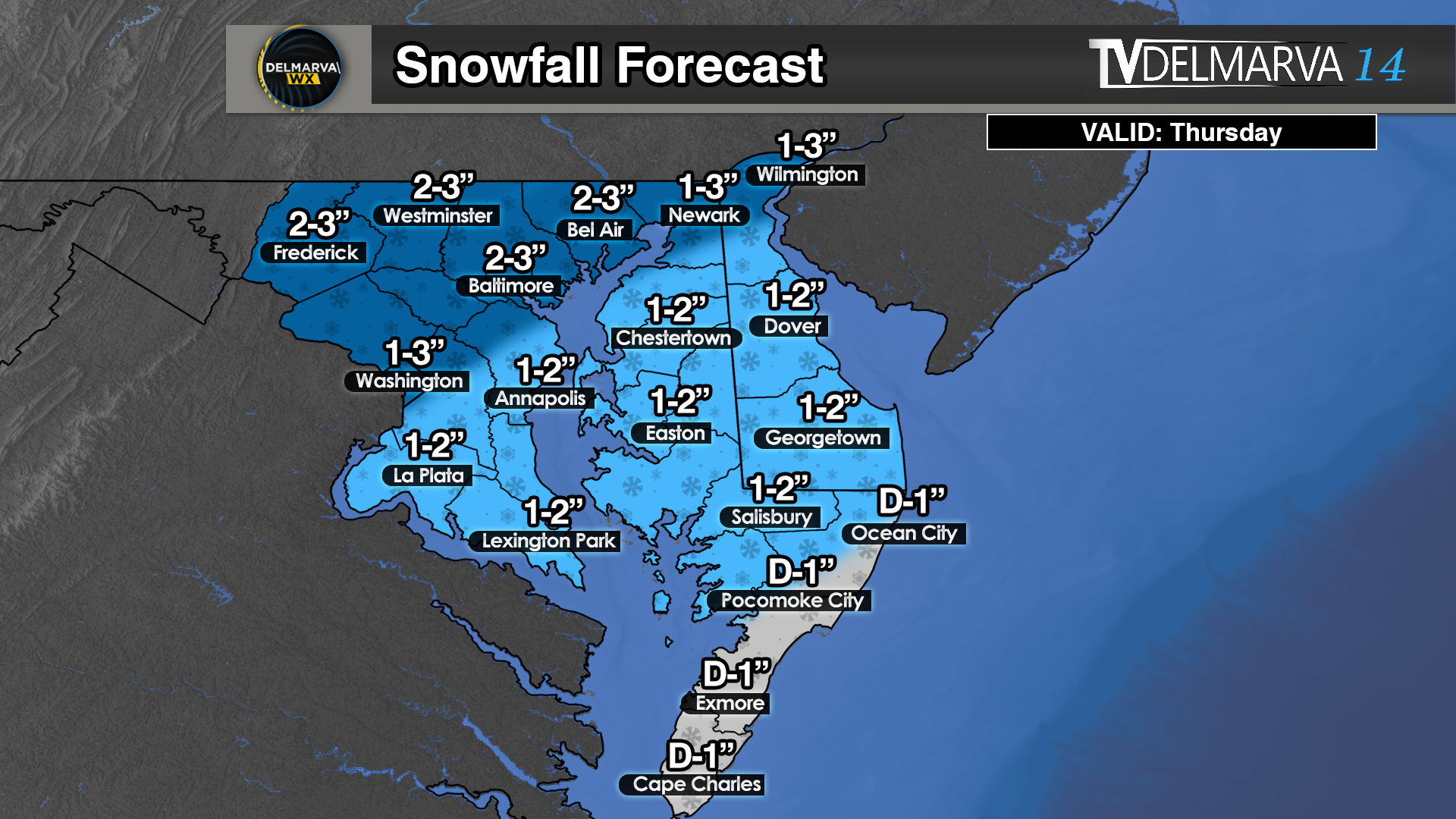
We are looking at a light snow event right along a arctic frontal boundary during the daytime hours on Thursday. We will begin the morning with temperatures well into the 30’s to near 40 degrees but will be quickly dropping throughout the day. Most locations will start off with some rain showers before transitioning over to snow by the mid morning hours. Temperatures will kick down sub freezing and a light accumulation snow is in the forecast. The greatest accumulations will be across north and western Maryland where as much as 3 inches is possible. Across areas of Delmarva a nice swaft of 1-2 inches is not out of the question. Further south in the Virginia counties will see a dusting to a inch where rates will be on the light side. For those down there you will have to wait until Saturday for a more substantial snow ahead.
We went from a extremely warm month of December, to now a January with a vengeance. With 2 snow events in our books and one being the biggest snowstorm in 4 years. We are not going to be done with those snow chances to finish out the month of January. The tropospheric polar vortex will remain quite dominate across Canada with a constant serious of troughs throughout the eastern half of the nation. With the polar vortex hanging around the Hudson Bay, this will allow several short waves to dip down from the Northern Plains all the way to the East Coast.
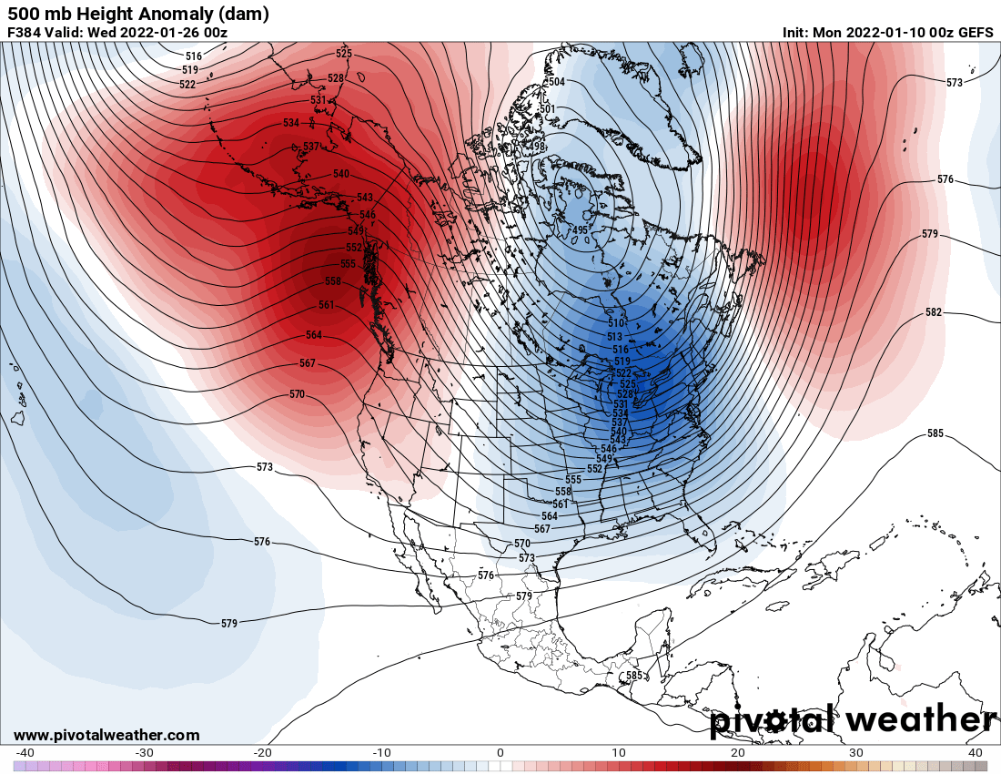
ECMWF EPS 500mb Heights
We are looking at a text book setup for cold and stormy across the eastern half of the nation. Strong ridging across the Pacific Northwest. Ridging over Greenland to act as a block for the persistent troughing across the Eastern US. This created the perfect Rossby Wave pattern for those who love the cold and snow. What is a Rossby Wave anyway? Rossby waves, also known as planetary waves, naturally occur in rotating fluids. Within the Earth’s ocean and atmosphere, these waves form as a result of the rotation of the planet.
Two sets of Omega Blocks across the Northern Hemisphere pattern. (Omega blocks get their name because the upper air pattern looks like the Greek letter omega (Ω). Omega blocks are a combination of two cutoff lows with one blocking high sandwiched between them.) This keeps these patterns locked in for an extended period of time. Like in this instance for the rest of the month. Get ready to see more arctic outbreaks and snow chances this month going forward. Several storm signals are becoming apparent beginning the 15th through the 26th.


